
Mobile River
Encyclopedia
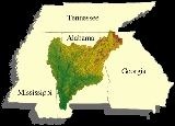
The Mobile River is located in southern Alabama
in the United States
. Formed out of the confluence of the Tombigbee
and Alabama
rivers, the approximately 45 miles (72.4 km) river drains an area of 44000 square miles (113,959.5 km²) of Alabama, with a watershed
extending into Mississippi
, Georgia
, and Tennessee
. Its drainage basin is the fourth-largest of primary stream drainage basins entirely in the United States. The river has historically provided the principal navigational access for Alabama. Since construction of the Tennessee-Tombigbee Waterway
, it also provides an alternative route into the Ohio River
watershed.
The Tombigbee and Alabama River join to form the Mobile River approximately 50 miles (80.5 km) north-northeast of Mobile
, along the county line between Mobile
and Baldwin
counties. The combined stream flows south, in a winding course. Approximately 6 miles (10 km) downstream from the confluence, the channel of the river divides, with the Mobile flowing along the western channel. The Tensaw River
, a bayou
of the Mobile River, flows alongside to the east, separated from 2 to 5 mi (3.2 to 8 ) as they flow southward. The Mobile River flows through the Mobile-Tensaw River Delta
and reaches Mobile Bay
on the Gulf of Mexico
just east of downtown Mobile.
of freshwater snail
species in the world (Bogan et al. 1995), including six genera and over 100 species that were endemic to the Mobile River Basin. During the past few decades, publications in the scientific literature have primarily dealt with the apparent decimation of this fauna following the construction of dams within the Mobile River Basin and the inundation of extensive shoal (a shallow place in a body of water) habitats by impounded waters (Goodrich 1944, Athearn 1970, Heard
1970, Stein 1976, Palmer 1986, Garner 1990).
s and other crossings of the Mobile River from Mobile Bay
upstream to its source at the confluence of the Tombigbee
and Alabama
rivers. Proposals for a new bridge to carry Interstate 10 over the river have been debated for several years. Currently the Alabama Department of Transportation is conducting an environmental impact study for such a crossing and into the widening of the Jubilee Parkway
, which carries Interstate 10 over Mobile Bay
. The location of this bridge is of great debate with some parties pushing for a crossing south of the current tunnels while others are opposed to anything south of the Cochrane–Africatown USA Bridge.
Alabama
Alabama is a state located in the southeastern region of the United States. It is bordered by Tennessee to the north, Georgia to the east, Florida and the Gulf of Mexico to the south, and Mississippi to the west. Alabama ranks 30th in total land area and ranks second in the size of its inland...
in the United States
United States
The United States of America is a federal constitutional republic comprising fifty states and a federal district...
. Formed out of the confluence of the Tombigbee
Tombigbee River
The Tombigbee River is a tributary of the Mobile River, approximately 200 mi long, in the U.S. states of Mississippi and Alabama. It is one of two major rivers, along with the Alabama River, that unite to form the short Mobile River before it empties into Mobile Bay on the Gulf of Mexico...
and Alabama
Alabama River
The Alabama River, in the U.S. state of Alabama, is formed by the Tallapoosa and Coosa rivers, which unite about north of Montgomery.The river flows west to Selma, then southwest until, about from Mobile, it unites with the Tombigbee, forming the Mobile and Tensaw rivers, which discharge into...
rivers, the approximately 45 miles (72.4 km) river drains an area of 44000 square miles (113,959.5 km²) of Alabama, with a watershed
Drainage basin
A drainage basin is an extent or an area of land where surface water from rain and melting snow or ice converges to a single point, usually the exit of the basin, where the waters join another waterbody, such as a river, lake, reservoir, estuary, wetland, sea, or ocean...
extending into Mississippi
Mississippi
Mississippi is a U.S. state located in the Southern United States. Jackson is the state capital and largest city. The name of the state derives from the Mississippi River, which flows along its western boundary, whose name comes from the Ojibwe word misi-ziibi...
, Georgia
Georgia (U.S. state)
Georgia is a state located in the southeastern United States. It was established in 1732, the last of the original Thirteen Colonies. The state is named after King George II of Great Britain. Georgia was the fourth state to ratify the United States Constitution, on January 2, 1788...
, and Tennessee
Tennessee
Tennessee is a U.S. state located in the Southeastern United States. It has a population of 6,346,105, making it the nation's 17th-largest state by population, and covers , making it the 36th-largest by total land area...
. Its drainage basin is the fourth-largest of primary stream drainage basins entirely in the United States. The river has historically provided the principal navigational access for Alabama. Since construction of the Tennessee-Tombigbee Waterway
Tennessee-Tombigbee Waterway
The Tennessee–Tombigbee Waterway is a 234-mile man-made, artificial waterway that extends from the Tennessee River to the junction of the Black Warrior-Tombigbee River system near Demopolis, Alabama, United States. The Tenneessee-Tombigbee Waterway links commercial navigation from the nation’s...
, it also provides an alternative route into the Ohio River
Ohio River
The Ohio River is the largest tributary, by volume, of the Mississippi River. At the confluence, the Ohio is even bigger than the Mississippi and, thus, is hydrologically the main stream of the whole river system, including the Allegheny River further upstream...
watershed.
The Tombigbee and Alabama River join to form the Mobile River approximately 50 miles (80.5 km) north-northeast of Mobile
Mobile, Alabama
Mobile is the third most populous city in the Southern US state of Alabama and is the county seat of Mobile County. It is located on the Mobile River and the central Gulf Coast of the United States. The population within the city limits was 195,111 during the 2010 census. It is the largest...
, along the county line between Mobile
Mobile County, Alabama
Mobile County[p] is a county of the U.S. state of Alabama. Its name is in honor of a tribe of Indians, the Maubila tribe . As of 2011, its population was 415,704. Its county seat is Mobile, Alabama...
and Baldwin
Baldwin County, Alabama
-2010:Whereas according to the 2010 U.S. Census Bureau:*85.7% White*9.4% Black*0.7% Native American*0.7% Asian*0.0% Native Hawaiian or Pacific Islander*1.5% Two or more races*4.4% Hispanic or Latino -2000:...
counties. The combined stream flows south, in a winding course. Approximately 6 miles (10 km) downstream from the confluence, the channel of the river divides, with the Mobile flowing along the western channel. The Tensaw River
Tensaw River
The Tensaw River is a distributary of the Mobile River, approximately 36 mi long, in southern Alabama in the United States. It is formed as a bayou of the Mobile approximately 6 mi south of the formation of the Mobile by the confluence of the Tombigbee and Alabama rivers...
, a bayou
Bayou
A bayou is an American term for a body of water typically found in flat, low-lying areas, and can refer either to an extremely slow-moving stream or river , or to a marshy lake or wetland. The name "bayou" can also refer to creeks that see level changes due to tides and hold brackish water which...
of the Mobile River, flows alongside to the east, separated from 2 to 5 mi (3.2 to 8 ) as they flow southward. The Mobile River flows through the Mobile-Tensaw River Delta
Mobile-Tensaw River Delta
The Mobile-Tensaw River Delta is the largest river delta and wetland in Alabama. It encompasses approximately in a 40 by area and is the second largest delta in the United States....
and reaches Mobile Bay
Mobile Bay
Mobile Bay is an inlet of the Gulf of Mexico, lying within the state of Alabama in the United States. Its mouth is formed by the Fort Morgan Peninsula on the eastern side and Dauphin Island, a barrier island on the western side. The Mobile River and Tensaw River empty into the northern end of the...
on the Gulf of Mexico
Gulf of Mexico
The Gulf of Mexico is a partially landlocked ocean basin largely surrounded by the North American continent and the island of Cuba. It is bounded on the northeast, north and northwest by the Gulf Coast of the United States, on the southwest and south by Mexico, and on the southeast by Cuba. In...
just east of downtown Mobile.
Biodiversity
The Mobile River Basin historically supported the greatest biodiversityBiodiversity
Biodiversity is the degree of variation of life forms within a given ecosystem, biome, or an entire planet. Biodiversity is a measure of the health of ecosystems. Biodiversity is in part a function of climate. In terrestrial habitats, tropical regions are typically rich whereas polar regions...
of freshwater snail
Snail
Snail is a common name applied to most of the members of the molluscan class Gastropoda that have coiled shells in the adult stage. When the word is used in its most general sense, it includes sea snails, land snails and freshwater snails. The word snail without any qualifier is however more often...
species in the world (Bogan et al. 1995), including six genera and over 100 species that were endemic to the Mobile River Basin. During the past few decades, publications in the scientific literature have primarily dealt with the apparent decimation of this fauna following the construction of dams within the Mobile River Basin and the inundation of extensive shoal (a shallow place in a body of water) habitats by impounded waters (Goodrich 1944, Athearn 1970, Heard
William H. Heard
William Henry Heard is a malacologist, and an authority on freshwater mollusks, especially freshwater pelecypods . He is an emeritus professor in the Department of Biological Sciences, at Florida State University....
1970, Stein 1976, Palmer 1986, Garner 1990).
Crossings
This is a list of bridgeBridge
A bridge is a structure built to span physical obstacles such as a body of water, valley, or road, for the purpose of providing passage over the obstacle...
s and other crossings of the Mobile River from Mobile Bay
Mobile Bay
Mobile Bay is an inlet of the Gulf of Mexico, lying within the state of Alabama in the United States. Its mouth is formed by the Fort Morgan Peninsula on the eastern side and Dauphin Island, a barrier island on the western side. The Mobile River and Tensaw River empty into the northern end of the...
upstream to its source at the confluence of the Tombigbee
Tombigbee River
The Tombigbee River is a tributary of the Mobile River, approximately 200 mi long, in the U.S. states of Mississippi and Alabama. It is one of two major rivers, along with the Alabama River, that unite to form the short Mobile River before it empties into Mobile Bay on the Gulf of Mexico...
and Alabama
Alabama River
The Alabama River, in the U.S. state of Alabama, is formed by the Tallapoosa and Coosa rivers, which unite about north of Montgomery.The river flows west to Selma, then southwest until, about from Mobile, it unites with the Tombigbee, forming the Mobile and Tensaw rivers, which discharge into...
rivers. Proposals for a new bridge to carry Interstate 10 over the river have been debated for several years. Currently the Alabama Department of Transportation is conducting an environmental impact study for such a crossing and into the widening of the Jubilee Parkway
Jubilee Parkway
The Jubilee Parkway is a pair of parallel concrete viaduct bridges that carry Interstate 10 across Mobile Bay from the George Wallace Tunnel in Mobile, Alabama eastbound to Spanish Fort/Daphne, Alabama. The bridges are similar in design to the I-10 Twin Span Bridge near New Orleans, Louisiana. Each...
, which carries Interstate 10 over Mobile Bay
Mobile Bay
Mobile Bay is an inlet of the Gulf of Mexico, lying within the state of Alabama in the United States. Its mouth is formed by the Fort Morgan Peninsula on the eastern side and Dauphin Island, a barrier island on the western side. The Mobile River and Tensaw River empty into the northern end of the...
. The location of this bridge is of great debate with some parties pushing for a crossing south of the current tunnels while others are opposed to anything south of the Cochrane–Africatown USA Bridge.
| Crossing | Carries | Location | Coordinates |
|---|---|---|---|
| George Wallace Tunnel George Wallace Tunnel The George Wallace Tunnel is a tunnel along Interstate 10 in Mobile, Alabama that crosses beneath the Mobile River.It, like the smaller Bankhead Tunnel a few blocks upriver from it, was constructed in Mobile at the shipyards of the Alabama Drydock and Shipbuilding Company from 1969-1973... |
 Interstate 10 Interstate 10Interstate 10 Interstate 10 is the fourth-longest Interstate Highway in the United States, after I-90, I-80, and I-40. It is the southernmost east–west, coast-to-coast Interstate Highway, although I-4 and I-8 are further south. It stretches from the Pacific Ocean at State Route 1 in Santa Monica,... |
Mobile Mobile, Alabama Mobile is the third most populous city in the Southern US state of Alabama and is the county seat of Mobile County. It is located on the Mobile River and the central Gulf Coast of the United States. The population within the city limits was 195,111 during the 2010 census. It is the largest... |
|
| Bankhead Tunnel Bankhead Tunnel The Bankhead Tunnel is a tunnel in Mobile, Alabama that begins on Government Street in downtown Mobile, travels eastbound under the Mobile River, and emerges to join the Battleship Parkway.... |
 U.S. Route 90 U.S. Route 90U.S. Route 90 U.S. Route 90 is an east–west United States highway. Despite the "0" in its route number, U.S. 90 never was a full coast-to-coast route; it has always ended at Van Horn, Texas. A short-lived northward extension to U.S...  U.S. Route 98 U.S. Route 98U.S. Route 98 U.S. Route 98 is an east–west United States highway that runs from western Mississippi to southern Florida. It was established in 1933 as a route between Pensacola, Florida and Apalachicola, Florida, and has since been extended westward into Mississippi and eastward across the Florida... |
||
| Cochrane–Africatown USA Bridge |  U.S. Route 90 U.S. Route 90U.S. Route 90 U.S. Route 90 is an east–west United States highway. Despite the "0" in its route number, U.S. 90 never was a full coast-to-coast route; it has always ended at Van Horn, Texas. A short-lived northward extension to U.S... U.S. Route 98U.S. Route 98 U.S. Route 98 is an east–west United States highway that runs from western Mississippi to southern Florida. It was established in 1933 as a route between Pensacola, Florida and Apalachicola, Florida, and has since been extended westward into Mississippi and eastward across the Florida... |
||
| 14-Mile Bridge | CSX | ||
| General W.K. Wilson Jr. Bridge General W.K. Wilson Jr. Bridge The General W.K. Wilson Jr. Bridge consists of two parallel tied arch bridges and adjoining concrete viaduct bridges that carry 4 lanes of Interstate 65 across the Mobile-Tensaw River delta northeast of the U.S. city of Mobile, Alabama. It was named in honor of Walter K. Wilson, a Chief of... |
 Interstate 65 Interstate 65Interstate 65 Interstate 65 is a major Interstate Highway in the United States. The southern terminus is located at an intersection with Interstate 10 in Mobile, Alabama, and its northern terminus is at an interchange with Interstate 90 , U.S. Route 12, and U.S... |