

Cape Cod Canal
Encyclopedia
Cape Cod
Cape Cod, often referred to locally as simply the Cape, is a cape in the easternmost portion of the state of Massachusetts, in the Northeastern United States...
to mainland Massachusetts
Massachusetts
The Commonwealth of Massachusetts is a state in the New England region of the northeastern United States of America. It is bordered by Rhode Island and Connecticut to the south, New York to the west, and Vermont and New Hampshire to the north; at its east lies the Atlantic Ocean. As of the 2010...
.
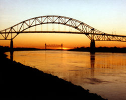
Part of the Atlantic Intracoastal Waterway, the canal
Canal
Canals are man-made channels for water. There are two types of canal:#Waterways: navigable transportation canals used for carrying ships and boats shipping goods and conveying people, further subdivided into two kinds:...
is roughly 17.4 miles (28 km) long (approximately 7 miles, or 11.3 km, of which are cut through land) and connects Cape Cod Bay
Cape Cod Bay
Cape Cod Bay is a large bay of the Atlantic Ocean adjacent to the U.S. state of Massachusetts. Measuring below a line drawn from Brant Rock in Marshfield to Race Point in Provincetown, Massachusetts, it is enclosed by Cape Cod to the south and east, and Plymouth County, Massachusetts, to the west....
in the north to Buzzards Bay
Buzzards Bay (bay)
Buzzards Bay is a bay of the Atlantic Ocean adjacent to the U.S. state of Massachusetts. It is approximately 28 miles long by 8 miles wide. It is a popular destination for fishing, boating, and tourism. Since 1914, Buzzards Bay has been connected to Cape Cod Bay by the Cape Cod Canal...
in the south. The 540-foot (164.6 meter) width of the canal is spanned by the Cape Cod Canal Railroad Bridge and two highway bridges—the Bourne and the Sagamore
Sagamore Bridge
The Sagamore Bridge in Sagamore, Massachusetts carries U.S. Route 6 across the Cape Cod Canal, connecting Cape Cod with the rest of Massachusetts, USA....
. Traffic lights govern the approach of vessels over 65 feet (19.8 m), and are located at either end of the canal.
The Massachusetts Maritime Academy
Massachusetts Maritime Academy
Massachusetts Maritime Academy is a regionally accredited, coeducational, state college offering undergraduate degrees in maritime-related fields, as well as graduate degrees and professional studies. Established in 1891, Mass Maritime is the second oldest state maritime academy in the country...
is located on Taylors Point at the south entrance of the canal.
Early history
The idea of constructing such a canal was first considered by Miles Standish of the Plymouth ColonyPlymouth Colony
Plymouth Colony was an English colonial venture in North America from 1620 to 1691. The first settlement of the Plymouth Colony was at New Plymouth, a location previously surveyed and named by Captain John Smith. The settlement, which served as the capital of the colony, is today the modern town...
in 1623, and Pilgrims scouted the low-lying stretch of land between the Manomet and the Scusset rivers for potential routes. William Bradford established the trading post
Trading post
A trading post was a place or establishment in historic Northern America where the trading of goods took place. The preferred travel route to a trading post or between trading posts, was known as a trade route....
of Aptuxcet in 1627 at the portage
Portage
Portage or portaging refers to the practice of carrying watercraft or cargo over land to avoid river obstacles, or between two bodies of water. A place where this carrying occurs is also called a portage; a person doing the carrying is called a porter.The English word portage is derived from the...
between the rivers. Trade with the Native Americans
Native Americans in the United States
Native Americans in the United States are the indigenous peoples in North America within the boundaries of the present-day continental United States, parts of Alaska, and the island state of Hawaii. They are composed of numerous, distinct tribes, states, and ethnic groups, many of which survive as...
of Narragansett Bay
Narragansett Bay
Narragansett Bay is a bay and estuary on the north side of Rhode Island Sound. Covering 147 mi2 , the Bay forms New England's largest estuary, which functions as an expansive natural harbor, and includes a small archipelago...
and the Dutch
Dutch people
The Dutch people are an ethnic group native to the Netherlands. They share a common culture and speak the Dutch language. Dutch people and their descendants are found in migrant communities worldwide, notably in Suriname, Chile, Brazil, Canada, Australia, South Africa, New Zealand, and the United...
of New Netherlands prospered and was a major factor enabling the Pilgrims to pay off their indebtedness. In 1697 the General Court of Massachusetts considered the first formal proposal to build the canal, but apparently took no action. More energetic planning with surveys
Surveying
See Also: Public Land Survey SystemSurveying or land surveying is the technique, profession, and science of accurately determining the terrestrial or three-dimensional position of points and the distances and angles between them...
took place repeatedly in 1776 (by George Washington
George Washington
George Washington was the dominant military and political leader of the new United States of America from 1775 to 1799. He led the American victory over Great Britain in the American Revolutionary War as commander-in-chief of the Continental Army from 1775 to 1783, and presided over the writing of...
), 1791, 1803, 1818, 1824–1830, and 1860. None of these efforts came to fruition. The first attempts at actually building a canal did not take place until the late 19th century; earlier planners either ran out of money or were overwhelmed by the project's size.
The engineers finally decided which route through the hillsides to take by connecting and widening the Manomet and Scusset Rivers.
Digging the canal
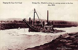
August Belmont, Jr.
August Belmont, Jr. was an American financier, the builder of New York's Belmont Park racetrack, and a major owner/breeder of thoroughbred racehorses.-Early life:...
Boston, Cape Cod & New York Canal Company, using designs by engineer William Barclay Parsons
William Barclay Parsons
William Barclay Parsons was an American civil engineer. He founded the firm that became Parsons Brinckerhoff, one of the largest American civil engineering firms....
. There were many problems that the engineers of the canal encountered. One was mammoth boulder
Boulder
In geology, a boulder is a rock with grain size of usually no less than 256 mm diameter. While a boulder may be small enough to move or roll manually, others are extremely massive....
s left by the retreat of Ice Age glaciers. Divers were hired to blow them up, but the effort slowed dredging. Another problem was cold winter storms, which forced the engineers to stop dredging altogether and wait for spring. Nevertheless, the canal opened, on a limited basis, in 1914, and it was completed in 1916. The privately-owned toll canal had a maximum width of one hundred feet (30 m), a maximum depth of 25 feet, and took a somewhat difficult route from Phinney Harbor http://www.mass.gov/dep/water/resources/mepmap.htm at the head of Buzzards Bay. Due to the narrow channel
Channel (geography)
In physical geography, a channel is the physical confine of a river, slough or ocean strait consisting of a bed and banks.A channel is also the natural or human-made deeper course through a reef, sand bar, bay, or any shallow body of water...
and navigation
Navigation
Navigation is the process of monitoring and controlling the movement of a craft or vehicle from one place to another. It is also the term of art used for the specialized knowledge used by navigators to perform navigation tasks...
difficulty, several accidents occurred which limited traffic and blackened the canal's reputation. As a result, despite shortening the trade route from New York City
New York City
New York is the most populous city in the United States and the center of the New York Metropolitan Area, one of the most populous metropolitan areas in the world. New York exerts a significant impact upon global commerce, finance, media, art, fashion, research, technology, education, and...
to Boston
Boston
Boston is the capital of and largest city in Massachusetts, and is one of the oldest cities in the United States. The largest city in New England, Boston is regarded as the unofficial "Capital of New England" for its economic and cultural impact on the entire New England region. The city proper had...
by 62 miles, toll revenues failed to meet investors' expectations.
A German U-boat
U-boat
U-boat is the anglicized version of the German word U-Boot , itself an abbreviation of Unterseeboot , and refers to military submarines operated by Germany, particularly in World War I and World War II...
, the U-156
Unterseeboot 156 (1917)
SM U-156 was a German Type U 151 U-boat commissioned in 1917 for the Kaiserliche Marine. From 1917 until her disappearance in September 1918 she was part of the U-Kreuzer Flotilla, and was responsible for sinking 44 ships and damaging 3 others, including a warship...
, surfaced three miles off Orleans
Orleans, Massachusetts
Orleans is a town in Barnstable County, Massachusetts, United States. Barnstable County is coextensive with Cape Cod. The population was 5,890 at the 2010 census....
, on July 21, 1918 and shelled the tug
Tugboat
A tugboat is a boat that maneuvers vessels by pushing or towing them. Tugs move vessels that either should not move themselves, such as ships in a crowded harbor or a narrow canal,or those that cannot move by themselves, such as barges, disabled ships, or oil platforms. Tugboats are powerful for...
Perth Amboy and her string of four barges
U-Boat Attack on Orleans, Massachusetts
The Attack on Orleans, in July 1918 was a naval and air action during the First World War. An Imperial German U-boat opened fire on the American town of Orleans, Massachusetts and several merchant vessels nearby...
. The Director General of the United States Railroad Administration
United States Railroad Administration
The United States Railroad Administration was the name of the nationalized railroad system of the United States between 1917 and 1920. It was possibly the largest American experiment with nationalization, and was undertaken against a background of war emergency.- Background :On April 6, 1917, the...
took over jurisdiction and operation of the canal four days later under a presidential proclamation. The United States Army Corps of Engineers
United States Army Corps of Engineers
The United States Army Corps of Engineers is a federal agency and a major Army command made up of some 38,000 civilian and military personnel, making it the world's largest public engineering, design and construction management agency...
re-dredged the channel to 25 feet deep while it remained under government control until 1920. In 1928, the government purchased the canal for use as a free public waterway. The purchase price was $11,400,000, and $21,000,000 was spent between 1935 to 1940 increasing the canal's width to 480 feet, and its depth to 32 feet. As a result, the canal became the widest sea level canal in the world. The southern entrance to the canal was rebuilt for direct access from Buzzards Bay rather than through Phinney Harbor. Before construction began, the Massachusetts Institute of Technology, built a huge scale model, of 9 feet to a mile, of the canal to study the effects of tidal currents on the enlarged and re-routed canal.
During World War II
World War II
World War II, or the Second World War , was a global conflict lasting from 1939 to 1945, involving most of the world's nations—including all of the great powers—eventually forming two opposing military alliances: the Allies and the Axis...
, shipping
Shipping
Shipping has multiple meanings. It can be a physical process of transporting commodities and merchandise goods and cargo, by land, air, and sea. It also can describe the movement of objects by ship.Land or "ground" shipping can be by train or by truck...
again used the canal to avoid U-boats patrolling offshore. The canal was protected from coastal batteries at Sagamore Hill Military Reservation
Sagamore Hill Military Reservation
Sagamore Hill Military Reservation was a coastal defense site located in Sagamore, Massachusetts.-History:The Sagamore Hill Military Reservation was built on state land. Its mission was to protect the Cape Cod Canal from possible air and naval attack...
. The Mystic Steamship Company's collier
Collier (ship type)
Collier is a historical term used to describe a bulk cargo ship designed to carry coal, especially for naval use by coal-fired warships. In the late 18th century a number of wooden-hulled sailing colliers gained fame after being adapted for use in voyages of exploration in the South Pacific, for...
Stephen R. Jones
USS Stephen R. Jones (ID-4526)
USS Stephen R. Jones was a cargo ship that served in the United States Navy from 1918 to 1919.SS Stephen R. Jones was built in 1915 as a commercial collier at Newport News, Virginia, by Newport News Shipbuilding and Drydock Company, and was delivered to her owners, the Crowell and Thurlow...
was grounded and sank in the canal on June 28, 1942. Shipping was routed around Cape Cod, and the SS Alexander Macomb
SS Alexander Macomb
SS Alexander Macomb was a Liberty ship of the United States Merchant Marine during World War II. Construction began on Hull 2023 on 18 February 1942 at the Bethlehem-Fairfield Shipyard of the Bethlehem Shipbuilding Corporation in Baltimore, Maryland, under Maritime Commission contract 0036. See,...
was torpedo
Torpedo
The modern torpedo is a self-propelled missile weapon with an explosive warhead, launched above or below the water surface, propelled underwater towards a target, and designed to detonate either on contact with it or in proximity to it.The term torpedo was originally employed for...
ed on July 3 with the loss of 10 lives. The canal reopened on July 31, after the wrecked Stephen R. Jones was removed with the help of 17 tons of dynamite
Dynamite
Dynamite is an explosive material based on nitroglycerin, initially using diatomaceous earth , or another absorbent substance such as powdered shells, clay, sawdust, or wood pulp. Dynamites using organic materials such as sawdust are less stable and such use has been generally discontinued...
.
Recreational uses
The canal is used extensively by recreational vessels.Service roads on both sides of the canal provide access for fishing and are heavily used by in-line skaters, bicyclists and walkers. Several parking areas are maintained at access points. People often just sit and watch ships and boats transiting the canal. Bourne Scenic Park is leased by the Corps of Engineers to the Town of Bourne Recreation Authority for use as a tent and RV campground adjacent to the Canal.
The Army Corps of Engineers maintains the Cape Cod Canal Visitor Center which introduces visitors to the history, features, and operation of the Canal. Features include a retired 41-foot US Army Corps of Engineers patrol boat, a 46-seat theater showing continuous DVD presentations on Canal history, Canal flora and fauna, real time radar and camera images of the waterway as well as a variety of interactive exhibits. Corps Park Rangers staff the centre and provide free public programs on a variety of subjects. Tide charts, Canal guides and brochures are also available. The Visitor Center is open seasonally from May to October. Admission is free. It is located on Moffitt Drive in Sandwich near the canal's east end. A second seasonally staffed center is at the Herring Run along Scenic Highway.
Scusset Beach State Reservation
Scusset Beach State Reservation
Scusset Beach State Reservation is a Massachusetts state park located in Sandwich in Barnstable County at the east end of the Cape Cod Canal. Unlike most of Sandwich, this section is on the mainland side of the Cape Cod Canal...
lies just north of the east end of the canal and offers beach facilities as well as tent and RV camping. A .7 mi (1.1 km) trail there leads to Sagamore Hill – once a Native American Indian meeting ground and later the site of a World War II coastal fortification with a fine overview of Cape Cod Bay.
Bournedale Hills Trail extends 1.4 mi (2.25 km) along the north side of the Canal from Bourne Scenic Park campground to the Herring Run. The trail includes a .8 mi (1.25 km) self guided loop which interprets the Canal's historic and natural features.