
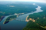
Black Warrior River
Overview
Waterway
A waterway is any navigable body of water. Waterways can include rivers, lakes, seas, oceans, and canals. In order for a waterway to be navigable, it must meet several criteria:...
in west central Alabama
Alabama
Alabama is a state located in the southeastern region of the United States. It is bordered by Tennessee to the north, Georgia to the east, Florida and the Gulf of Mexico to the south, and Mississippi to the west. Alabama ranks 30th in total land area and ranks second in the size of its inland...
in the southeastern United States
United States
The United States of America is a federal constitutional republic comprising fifty states and a federal district...
. The river rises in the extreme southern edges of the Appalachian Highlands and flows 178 miles (286 km) to the Tombigbee River
Tombigbee River
The Tombigbee River is a tributary of the Mobile River, approximately 200 mi long, in the U.S. states of Mississippi and Alabama. It is one of two major rivers, along with the Alabama River, that unite to form the short Mobile River before it empties into Mobile Bay on the Gulf of Mexico...
, of which the Black Warrior is the primary tributary
Tributary
A tributary or affluent is a stream or river that flows into a main stem river or a lake. A tributary does not flow directly into a sea or ocean...
. The river is named after the Mississippian
Mississippian culture
The Mississippian culture was a mound-building Native American culture that flourished in what is now the Midwestern, Eastern, and Southeastern United States from approximately 800 CE to 1500 CE, varying regionally....
paramount chief
Paramount chief
A paramount chief is the highest-level traditional chief or political leader in a regional or local polity or country typically administered politically with a chief-based system. This definition is used occasionally in anthropological and archaeological theory to refer to the rulers of multiple...
Tuskaloosa, whose name meant Black Warrior in Muskogean
Muskogean languages
Muskogean is an indigenous language family of the Southeastern United States. Though there is an ongoing debate concerning their interrelationships, the Muskogean languages are generally divided into two branches, Eastern Muskogean and Western Muskogean...
. The Black Warrior is impounded along nearly its entire course by a series of locks and dams to form a chain of narrow reservoirs, which not only provide aid to navigation, but hydroelectric power
Hydroelectricity
Hydroelectricity is the term referring to electricity generated by hydropower; the production of electrical power through the use of the gravitational force of falling or flowing water. It is the most widely used form of renewable energy...
and drinking water.
The river flows through the Black Warrior Basin
Black Warrior Basin
The Black Warrior Basin is a geologic sedimentary basin of western Alabama and northern Mississippi in the United States. It is named for the Black Warrior River and is developed for coal and coalbed methane production, as well as for conventional oil and natural gas production...
, a region historically important for the extraction of coal and methane.