
American River
Encyclopedia
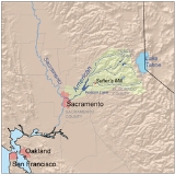
The American River is a California watercourse noted as the site of Sutter's Mill
, northwest of Placerville, California
, where gold was found in 1848, leading to the California Gold Rush
. This river runs from the Sierra Nevada mountain range
, through the Sacramento
metropolitan area, where it enters into the Sacramento River
on its way to the San Francisco Bay
. Today the American River is known for its whitewater rapid
s.
, Placer County
, and Sacramento County
in the Sierra Nevada mountain range of northern California. The river originates in the Tahoe
and Eldorado National Forest
s. From the confluence at Auburn, the combined North and Middle Forks river flows at an elevation of 600 feet (182.9 m) in a forested canyon 800 feet (243.8 m) deep and is called the North Fork. It meanders through additional wilderness recreational canyons past the site of the abandoned Auburn Dam
, and back into wilderness, onward to where it meets the South Fork at Folsom Lake
. All three forks are known for their verdant canyons, forested ridges, massive rock formations, trails, backcountry winter adventuring among snowy peaks, fishing and white water rafting.
Below Folsom Lake
, the river passes through an urbanized area but is buffered by a riparian park, the American River Parkway
. Containing fishing and family-oriented rafting, and paved bicycling and multi-use trails, it runs 30.6 miles (49.2 km) from Folsom Lake to the river's confluence with the Sacramento River. The American River Parkway incorporates Historic Leidesdorff
Ranch, a 35000 acres (141.6 km²) cattle and wheat agribusiness owned by the "African Founding Father of California." Jedediah Smith Memorial Trail
, a meandering, uninterrupted 32 miles (51.5 km) cycle path, hugs the river bank from Old Sacramento to Folsom Lake
.
in Placer County at the snowcapped crest of the Sierras. The North Fork originates at or near Mountain Meadow Lake, just northeast of Granite Chief
and immediately due west of Squaw Valley Ski Resort
. It flows westward through remote wilderness areas. The North Fork and its tributaries provides one of the most biologically diverse habitats in North America. The North Fork features scenic multi-use trails along forested ridgetops and riparian corridors. It flows freely as a federally eligible National Wild and Scenic Rivers System river until a small debris dam, Clementine, immediately north of the Foresthill Bridge
and prior to the confluence
with the Middle Fork at Auburn, California
. Both the North Fork and Middle Fork feature archaeological and historic sites of ancient American Indian
culture and 1850s Gold Rush habitation.
, and agricultural timber cultivation and harvesting. The Middle Fork features the Western States Trail, which hosts multiple annual endurance events, including the prestigious Tevis Cup equestrian trail ride and the world-famous Western States 100- Mile Trail Run, both beginning at Squaw Valley and leading to Auburn via remote wilderness trails.
south of Lake Tahoe in El Dorado County, just south of where U.S. Route 50
makes a sharp curve northward to descend into Tahoe Valley. The South Fork has multi-use recreational areas, including the Rubicon Trail for motorized adventuring and whitewater rafting venues. The South Fork also features Coloma
, the site where gold was discovered in California in 1848. Trout fishing and recreational gold panning
are popular family activities.
The Silver Fork American River is a 20 miles (32.2 km) tributary of the South Fork American River (confluence at 38.767636°N 120.315828°W) that begins within the west Sierra slope (38.614188°N 120.120263°W) and has a branch (Caples Creek) that drains from Winemucca Lake and the Sierra Crest
(38.663933°N 119.985595°W). The American River's section of the Sierra Crest extends ~50 mi (80.5 km) between the north triple watershed point (South Yuba
, North Fork American, and Truckee
rivers) at Mount Lincoln (39°17′16"N 120°19′41"W) to the Winemucca Lake triple point (Sacramento
, San Joaquin
, and central Lahontan hydrologic subregions).
Like most major western U.S. rivers, the American River has been extensively dammed and diverted for hydroelectricity
production. Bunch Creek
is one of the tributaries of the North Fork of the American River. Since the California Gold Rush
was centered along the American River basin, it was one of the earlier California rivers to be populated, beginning at Leidesdorff Ranch, owned by William Leidesdorff
. Water was used to drive grist mills
. By the end of the 19th century, some of these mill sites were converted to the earliest hydroelectric plants, with Folsom State Prison
's using the river to generate electricity in 1893. The Natoma Company completed its Folsom Powerhouse
by 1895 and began delivering power 22 miles (35 km) away to the city of Sacramento
.
Today, five power plants on the Middle Fork are owned by the Placer County Water Agency. On the South Fork, SMUD owns eight plants, El Dorado Irrigation District and PG&E
each own one plant (Akin Powerhouse and Chili Bar Powerhouse, respectively), and the eleventh plant is owned by a small private concern (Rock Creek Powerhouse). The SMUD plants are run on a peaking
basis, although recreational boating and environmental flow requirements constrain their operation slightly. None of these upstream plants are constrained by flood control requirements plants on the upstream tributaries, the needs of water supply and flood control largely govern their operation.
Sutter's Mill
Sutter's Mill was a sawmill owned by 19th century pioneer John Sutter in partnership with James W. Marshall. It was located in Coloma, California, at the bank of the South Fork American River...
, northwest of Placerville, California
Placerville, California
Placerville is the county seat of El Dorado County, California. The population was 10,389 at the 2010 census, up from 9,610 at the 2000 census. It is part of the Sacramento–Arden-Arcade–Roseville Metropolitan Statistical Area.-Geography:...
, where gold was found in 1848, leading to the California Gold Rush
California Gold Rush
The California Gold Rush began on January 24, 1848, when gold was found by James W. Marshall at Sutter's Mill in Coloma, California. The first to hear confirmed information of the gold rush were the people in Oregon, the Sandwich Islands , and Latin America, who were the first to start flocking to...
. This river runs from the Sierra Nevada mountain range
Mountain range
A mountain range is a single, large mass consisting of a succession of mountains or narrowly spaced mountain ridges, with or without peaks, closely related in position, direction, formation, and age; a component part of a mountain system or of a mountain chain...
, through the Sacramento
Sacramento, California
Sacramento is the capital city of the U.S. state of California and the county seat of Sacramento County. It is located at the confluence of the Sacramento River and the American River in the northern portion of California's expansive Central Valley. With a population of 466,488 at the 2010 census,...
metropolitan area, where it enters into the Sacramento River
Sacramento River
The Sacramento River is an important watercourse of Northern and Central California in the United States. The largest river in California, it rises on the eastern slopes of the Klamath Mountains, and after a journey south of over , empties into Suisun Bay, an arm of the San Francisco Bay, and...
on its way to the San Francisco Bay
San Francisco Bay
San Francisco Bay is a shallow, productive estuary through which water draining from approximately forty percent of California, flowing in the Sacramento and San Joaquin rivers from the Sierra Nevada mountains, enters the Pacific Ocean...
. Today the American River is known for its whitewater rapid
Rapid
A rapid is a section of a river where the river bed has a relatively steep gradient causing an increase in water velocity and turbulence. A rapid is a hydrological feature between a run and a cascade. A rapid is characterised by the river becoming shallower and having some rocks exposed above the...
s.
Course
The American River is divided into the North, Middle, and South forks that contain recreational havens for well over one million visitors per year in El Dorado CountyEl Dorado County, California
El Dorado County is a county located in the historic Gold Country in the Sierra Nevada Mountains and foothills of the U.S. state of California. The 2010 population was 181,058. The El Dorado county seat is in Placerville....
, Placer County
Placer County, California
Placer County is a county located in both the Sacramento Valley and Sierra Nevada regions of the U.S. state of California, in what is known as the Gold Country. It stretches from the suburbs of Sacramento to Lake Tahoe and the Nevada border. Because of the expansion of the Greater Sacramento,...
, and Sacramento County
Sacramento County, California
Sacramento County is a county in the U.S. state of California. Its county seat is Sacramento, which is also the state capital. As of 2010 the county had a population of 1,418,788....
in the Sierra Nevada mountain range of northern California. The river originates in the Tahoe
Tahoe National Forest
Tahoe National Forest is a U.S. National Forest located in the state of California, northwest of Lake Tahoe. It includes the peak of Sierra Buttes, near Sierra City, which has views of Mount Lassen and Mount Shasta. It is located in parts of six counties. In descending order of forestland area...
and Eldorado National Forest
Eldorado National Forest
Eldorado National Forest is a U.S. National Forest located in the central Sierra Nevada mountain range, in eastern Eldorado National Forest is a [[U.S. National Forest]] located in the central [[Sierra Nevada |Sierra Nevada]] [[mountain range]], in eastern Eldorado National Forest is a [[U.S...
s. From the confluence at Auburn, the combined North and Middle Forks river flows at an elevation of 600 feet (182.9 m) in a forested canyon 800 feet (243.8 m) deep and is called the North Fork. It meanders through additional wilderness recreational canyons past the site of the abandoned Auburn Dam
Auburn Dam
Auburn Dam was a proposed dam on the North Fork of the American River east of the town of Auburn, California in the United States, on the border of Placer and El Dorado Counties. Slated to be completed in the 1970s by the U.S...
, and back into wilderness, onward to where it meets the South Fork at Folsom Lake
Folsom Lake
Folsom Lake is a reservoir in Northern California about northeast of Sacramento in Placer, El Dorado, and Sacramento Counties. The lake is formed by Folsom Dam, constructed in 1955 to control the American River. The dam and lake are part of the Folsom Project, which also includes the Nimbus...
. All three forks are known for their verdant canyons, forested ridges, massive rock formations, trails, backcountry winter adventuring among snowy peaks, fishing and white water rafting.
Below Folsom Lake
Folsom Lake
Folsom Lake is a reservoir in Northern California about northeast of Sacramento in Placer, El Dorado, and Sacramento Counties. The lake is formed by Folsom Dam, constructed in 1955 to control the American River. The dam and lake are part of the Folsom Project, which also includes the Nimbus...
, the river passes through an urbanized area but is buffered by a riparian park, the American River Parkway
American River Parkway
The American River Parkway is a parkway that runs along the American River throughout Sacramento County, California and consists of many smaller parks and boat launching points...
. Containing fishing and family-oriented rafting, and paved bicycling and multi-use trails, it runs 30.6 miles (49.2 km) from Folsom Lake to the river's confluence with the Sacramento River. The American River Parkway incorporates Historic Leidesdorff
William Leidesdorff
William Alexander Leidesdorff, Jr. was one of the earliest mixed-race U.S. citizens in California and a highly successful, enterprising businessman. He was a West Indian immigrant of African Cuban, possibly Carib, Danish and Jewish ancestry. William Alexander Leidesdorff, Jr. became a United...
Ranch, a 35000 acres (141.6 km²) cattle and wheat agribusiness owned by the "African Founding Father of California." Jedediah Smith Memorial Trail
Jedediah Smith Memorial Trail
The Jedediah Smith Memorial Trail is a paved multi-use pathway that runs between the confluence of the Sacramento River with the American River, just north of downtown Sacramento, CA, and Beal's Point at Folsom Lake, north of Folsom, CA. The trail is long, and is used as a major recreational...
, a meandering, uninterrupted 32 miles (51.5 km) cycle path, hugs the river bank from Old Sacramento to Folsom Lake
Folsom Lake
Folsom Lake is a reservoir in Northern California about northeast of Sacramento in Placer, El Dorado, and Sacramento Counties. The lake is formed by Folsom Dam, constructed in 1955 to control the American River. The dam and lake are part of the Folsom Project, which also includes the Nimbus...
.
North Fork
The North Fork is the longest tributary of the American River, at 88 miles (141.6 km). It begins at an elevation of 7089 feet (2,160.7 m) near Lake TahoeLake Tahoe
Lake Tahoe is a large freshwater lake in the Sierra Nevada of the United States. At a surface elevation of , it is located along the border between California and Nevada, west of Carson City. Lake Tahoe is the largest alpine lake in North America. Its depth is , making it the USA's second-deepest...
in Placer County at the snowcapped crest of the Sierras. The North Fork originates at or near Mountain Meadow Lake, just northeast of Granite Chief
Granite Chief
Granite Chief is a mountain located in the Sierra Nevada near Lake Tahoe. The mountain rises to an elevation of and receives consistent heavy snowfall during the winter months....
and immediately due west of Squaw Valley Ski Resort
Squaw Valley Ski Resort
Squaw Valley Ski Resort in Olympic Valley, California, is one of the largest ski areas in the United States, and was the site of the 1960 Winter Olympics. It is the second-largest ski area at Lake Tahoe , with 33 chairlifts, and has the only funitel lift in the U.S...
. It flows westward through remote wilderness areas. The North Fork and its tributaries provides one of the most biologically diverse habitats in North America. The North Fork features scenic multi-use trails along forested ridgetops and riparian corridors. It flows freely as a federally eligible National Wild and Scenic Rivers System river until a small debris dam, Clementine, immediately north of the Foresthill Bridge
Foresthill Bridge
The Foresthill Bridge over the North Fork of the American River is the highest bridge in the U.S. state of California. It is sometimes referred to as the Auburn-Foresthill Bridge or the Auburn Bridge....
and prior to the confluence
Confluence (geography)
In geography, a confluence is the meeting of two or more bodies of water. It usually refers to the point where two streams flow together, merging into a single stream...
with the Middle Fork at Auburn, California
Auburn, California
Auburn is the county seat of Placer County, California. Its population at the 2010 census was 13,330. Auburn is known for its California Gold Rush history.Auburn is part of the Greater Sacramento area.- History :...
. Both the North Fork and Middle Fork feature archaeological and historic sites of ancient American Indian
Indigenous peoples of the Americas
The indigenous peoples of the Americas are the pre-Columbian inhabitants of North and South America, their descendants and other ethnic groups who are identified with those peoples. Indigenous peoples are known in Canada as Aboriginal peoples, and in the United States as Native Americans...
culture and 1850s Gold Rush habitation.
Middle Fork
The 62 miles (99.8 km) Middle Fork originates near the source of the North Fork but on the south face of Granite Chief, between the summit and Emigrant Pass. It is characterized by somewhat broader steep canyons interspersed with manmade reservoirs, natural waterfalls, and quiet riparian areas. The Middle Fork is used extensively for both motorized and non-motorized recreation, including fishing, white water adventuring, bicycling (mountain and road), horseback riding, trail running and hiking. It contains areas used for hydroelectric generation, miningMining
Mining is the extraction of valuable minerals or other geological materials from the earth, from an ore body, vein or seam. The term also includes the removal of soil. Materials recovered by mining include base metals, precious metals, iron, uranium, coal, diamonds, limestone, oil shale, rock...
, and agricultural timber cultivation and harvesting. The Middle Fork features the Western States Trail, which hosts multiple annual endurance events, including the prestigious Tevis Cup equestrian trail ride and the world-famous Western States 100- Mile Trail Run, both beginning at Squaw Valley and leading to Auburn via remote wilderness trails.
South Fork
The 87 miles (140 km) South Fork originates at Echo Summit near Echo LakeEcho Lake (California)
Echo Lake, is the name of a glacial lake located in El Dorado County, California, U.S.A. It is about 2 miles off Highway 50 at Echo Summit. The lake is divided into two sections; an Upper lake, and a Lower lake. The elevation of Echo lake is maintained in summer months with a dam at 7,414 feet...
south of Lake Tahoe in El Dorado County, just south of where U.S. Route 50
U.S. Route 50
U.S. Route 50 is a major east–west route of the U.S. Highway system, stretching just over from Ocean City, Maryland on the Atlantic Ocean to West Sacramento, California. Until 1972, when it was replaced by Interstate Highways west of the Sacramento area, it extended to San Francisco, near...
makes a sharp curve northward to descend into Tahoe Valley. The South Fork has multi-use recreational areas, including the Rubicon Trail for motorized adventuring and whitewater rafting venues. The South Fork also features Coloma
Coloma, California
Coloma is a census-designated place in El Dorado County, California, USA. It is approximately northeast of Sacramento, California. Coloma is most noted for being the site where James W. Marshall first discovered gold in California, at Sutter's Mill on January 24, 1848, leading to the California...
, the site where gold was discovered in California in 1848. Trout fishing and recreational gold panning
Gold panning
Gold panning, or simply panning, is a form of placer mining that extracts gold from a placer deposit using a pan. The process is one of the simplest ways to extract gold, and is popular with geology enthusiasts because of its cheap cost and the relatively simple and easy process involved. It is the...
are popular family activities.
The Silver Fork American River is a 20 miles (32.2 km) tributary of the South Fork American River (confluence at 38.767636°N 120.315828°W) that begins within the west Sierra slope (38.614188°N 120.120263°W) and has a branch (Caples Creek) that drains from Winemucca Lake and the Sierra Crest
Sierra Crest
The Sierra Crest is a ~ generally north-to-south ridgeline that demarcates the broad west and narrow east slopes of the Sierra Nevada and that extends as far east as the Sierra's topographic front...
(38.663933°N 119.985595°W). The American River's section of the Sierra Crest extends ~50 mi (80.5 km) between the north triple watershed point (South Yuba
Yuba River
The Yuba River is a tributary of the Feather River in the Sacramento Valley of the U.S. state of California. It is one of the Feather's most important branches, providing about a third of its flow. The main stem of the river is about long, and its headwaters are split into North, Middle and South...
, North Fork American, and Truckee
Truckee River
The Truckee River is a stream in the U.S. states of California and Nevada. The river is about long. Its endorheic drainage basin is about , of which about are in Nevada. The Truckee is the sole outlet of Lake Tahoe and drains part of the high Sierra Nevada, emptying into Pyramid Lake in the Great...
rivers) at Mount Lincoln (39°17′16"N 120°19′41"W) to the Winemucca Lake triple point (Sacramento
Sacramento River
The Sacramento River is an important watercourse of Northern and Central California in the United States. The largest river in California, it rises on the eastern slopes of the Klamath Mountains, and after a journey south of over , empties into Suisun Bay, an arm of the San Francisco Bay, and...
, San Joaquin
San Joaquin River
The San Joaquin River is the largest river of Central California in the United States. At over long, the river starts in the high Sierra Nevada, and flows through a rich agricultural region known as the San Joaquin Valley before reaching Suisun Bay, San Francisco Bay, and the Pacific Ocean...
, and central Lahontan hydrologic subregions).
Like most major western U.S. rivers, the American River has been extensively dammed and diverted for hydroelectricity
Hydroelectricity
Hydroelectricity is the term referring to electricity generated by hydropower; the production of electrical power through the use of the gravitational force of falling or flowing water. It is the most widely used form of renewable energy...
production. Bunch Creek
Bunch Creek
Bunch Creek is a stream in Placer County, California, USA. Bunch Creek is a tributary to the North Fork of the American River, which confluence is to the east at elevation. In reaching that confluence, Brush Creek flows through Bunch Canyon...
is one of the tributaries of the North Fork of the American River. Since the California Gold Rush
California Gold Rush
The California Gold Rush began on January 24, 1848, when gold was found by James W. Marshall at Sutter's Mill in Coloma, California. The first to hear confirmed information of the gold rush were the people in Oregon, the Sandwich Islands , and Latin America, who were the first to start flocking to...
was centered along the American River basin, it was one of the earlier California rivers to be populated, beginning at Leidesdorff Ranch, owned by William Leidesdorff
William Leidesdorff
William Alexander Leidesdorff, Jr. was one of the earliest mixed-race U.S. citizens in California and a highly successful, enterprising businessman. He was a West Indian immigrant of African Cuban, possibly Carib, Danish and Jewish ancestry. William Alexander Leidesdorff, Jr. became a United...
. Water was used to drive grist mills
Gristmill
The terms gristmill or grist mill can refer either to a building in which grain is ground into flour, or to the grinding mechanism itself.- Early history :...
. By the end of the 19th century, some of these mill sites were converted to the earliest hydroelectric plants, with Folsom State Prison
Folsom State Prison
Folsom State Prison is a California State Prison located in the city of Folsom, California, northeast from the state capital of Sacramento. Opened in 1880, Folsom is the second-oldest prison in the state of California after San Quentin and was the first in the country to have electricity...
's using the river to generate electricity in 1893. The Natoma Company completed its Folsom Powerhouse
Folsom Powerhouse State Historic Park
Folsom Powerhouse State Historic Park is a historical site located in Folsom near Sacramento, California, in the United States. Built in the late 19th century by the Natoma Water and Mining Company and prison labor from Folsom Prison, the hydroelelectric powerhouse first delivered power to...
by 1895 and began delivering power 22 miles (35 km) away to the city of Sacramento
Sacramento, California
Sacramento is the capital city of the U.S. state of California and the county seat of Sacramento County. It is located at the confluence of the Sacramento River and the American River in the northern portion of California's expansive Central Valley. With a population of 466,488 at the 2010 census,...
.
Today, five power plants on the Middle Fork are owned by the Placer County Water Agency. On the South Fork, SMUD owns eight plants, El Dorado Irrigation District and PG&E
Pacific Gas and Electric Company
The Pacific Gas and Electric Company , commonly known as PG&E, is the utility that provides natural gas and electricity to most of the northern two-thirds of California, from Bakersfield almost to the Oregon border...
each own one plant (Akin Powerhouse and Chili Bar Powerhouse, respectively), and the eleventh plant is owned by a small private concern (Rock Creek Powerhouse). The SMUD plants are run on a peaking
Peaking power plant
Peaking power plants, also known as peaker plants, and occasionally just "peakers," are power plants that generally run only when there is a high demand, known as peak demand, for electricity.-Peak hours:...
basis, although recreational boating and environmental flow requirements constrain their operation slightly. None of these upstream plants are constrained by flood control requirements plants on the upstream tributaries, the needs of water supply and flood control largely govern their operation.