
Geology of the Death Valley area
Encyclopedia

Death Valley National Park
Death Valley National Park is a national park in the U.S. states of California and Nevada located east of the Sierra Nevada in the arid Great Basin of the United States. The park protects the northwest corner of the Mojave Desert and contains a diverse desert environment of salt-flats, sand dunes,...
are extensively metamorphosed by intense heat and pressure and are at least 1700 million years
Mesoproterozoic
The Mesoproterozoic Era is a geologic era that occurred between 1600 Ma and 1000 Ma . The Mesoproterozoic was the first period of Earth's history with a respectable geological record. Continents existed in the Paleoproterozoic, but we know little about them...
old. These rocks were intruded by a mass of granite 1400 Ma (million years ago) and later uplifted and exposed to nearly 500 million years of erosion.
Marine deposition occurred 1200 to 800 Ma
Neoproterozoic
The Neoproterozoic Era is the unit of geologic time from 1,000 to 542.0 ± 1.0 million years ago. The terminal Era of the formal Proterozoic Eon , it is further subdivided into the Tonian, Cryogenian, and Ediacaran Periods...
, creating thick sequences of conglomerate
Conglomerate (geology)
A conglomerate is a rock consisting of individual clasts within a finer-grained matrix that have become cemented together. Conglomerates are sedimentary rocks consisting of rounded fragments and are thus differentiated from breccias, which consist of angular clasts...
, mudstone
Mudstone
Mudstone is a fine grained sedimentary rock whose original constituents were clays or muds. Grain size is up to 0.0625 mm with individual grains too small to be distinguished without a microscope. With increased pressure over time the platey clay minerals may become aligned, with the...
, and carbonate rock
Carbonate rock
Carbonate rocks are a class of sedimentary rocks composed primarily of carbonate minerals. The two major types are limestone, which is composed of calcite or aragonite and dolostone, which is composed of the mineral dolomite .Calcite can be either dissolved by groundwater or precipitated by...
topped by stromatolite
Stromatolite
Stromatolites or stromatoliths are layered accretionary structures formed in shallow water by the trapping, binding and cementation of sedimentary grains by biofilms of microorganisms, especially cyanobacteria ....
s, and possibly glacial deposits from the hypothesized Snowball Earth
Snowball Earth
The Snowball Earth hypothesis posits that the Earth's surface became entirely or nearly entirely frozen at least once, some time earlier than 650 Ma . Proponents of the hypothesis argue that it best explains sedimentary deposits generally regarded as of glacial origin at tropical...
event. Rift
Rift
In geology, a rift or chasm is a place where the Earth's crust and lithosphere are being pulled apart and is an example of extensional tectonics....
ing thinned huge roughly linear parts of the supercontinent Rodinia
Rodinia
In geology, Rodinia is the name of a supercontinent, a continent which contained most or all of Earth's landmass. According to plate tectonic reconstructions, Rodinia existed between 1.1 billion and 750 million years ago, in the Neoproterozoic era...
enough to allow sea water to invade and divide its landmass into component continents separated by narrow straits. A passive margin
Passive margin
A passive margin is the transition between oceanic and continental crust which is not an active plate margin. It is constructed by sedimentation above an ancient rift, now marked by transitional crust. Continental rifting creates new ocean basins. Eventually the continental rift forms a mid-oceanic...
developed on the edges of these new seas in the Death Valley region. Carbonate banks formed on this part of the two margins
Plate tectonics
Plate tectonics is a scientific theory that describes the large scale motions of Earth's lithosphere...
only to be subsided as the continental crust
Continental crust
The continental crust is the layer of igneous, sedimentary, and metamorphic rocks which form the continents and the areas of shallow seabed close to their shores, known as continental shelves. This layer is sometimes called sial due to more felsic, or granitic, bulk composition, which lies in...
thinned until it broke, giving birth to a new ocean basin. An accretion
Accretion (geology)
Accretion is a process by which material is added to a tectonic plate or a landmass. This material may be sediment, volcanic arcs, seamounts or other igneous features.-Description:...
wedge of clastic sediment then started to accumulate at the base of the submerged precipice, entombing the region's first known fossils of complex life. These sandy mudflats gave way about 550 Ma
Ediacaran
The Ediacaran Period , named after the Ediacara Hills of South Australia, is the last geological period of the Neoproterozoic Era and of the Proterozoic Eon, immediately preceding the Cambrian Period, the first period of the Paleozoic Era and of the Phanerozoic Eon...
to a carbonate platform
Carbonate platform
A carbonate platform is a sedimentary body which possesses topographic relief, and is composed of autochthonous calcareous deposits . Platform growth is mediated by sessile organisms whose skeletons build up the reef or by organisms which induce carbonate precipitation through their metabolism...
which lasted for the next 300 million years of Paleozoic
Paleozoic
The Paleozoic era is the earliest of three geologic eras of the Phanerozoic eon, spanning from roughly...
time.
The passive margin switched to active margin in the early-to-mid Mesozoic
Mesozoic
The Mesozoic era is an interval of geological time from about 250 million years ago to about 65 million years ago. It is often referred to as the age of reptiles because reptiles, namely dinosaurs, were the dominant terrestrial and marine vertebrates of the time...
when the Farallon Plate
Farallon Plate
The Farallon Plate was an ancient oceanic plate, which began subducting under the west coast of the North American Plate— then located in modern Utah— as Pangaea broke apart during the Jurassic Period...
under the Pacific Ocean
Pacific Ocean
The Pacific Ocean is the largest of the Earth's oceanic divisions. It extends from the Arctic in the north to the Southern Ocean in the south, bounded by Asia and Australia in the west, and the Americas in the east.At 165.2 million square kilometres in area, this largest division of the World...
started to dive below the North American Plate
North American Plate
The North American Plate is a tectonic plate covering most of North America, Greenland, Cuba, Bahamas, and parts of Siberia, Japan and Iceland. It extends eastward to the Mid-Atlantic Ridge and westward to the Chersky Range in eastern Siberia. The plate includes both continental and oceanic crust...
, creating a subduction zone; volcano
Volcano
2. Bedrock3. Conduit 4. Base5. Sill6. Dike7. Layers of ash emitted by the volcano8. Flank| 9. Layers of lava emitted by the volcano10. Throat11. Parasitic cone12. Lava flow13. Vent14. Crater15...
es and uplifting mountains were created as a result. Erosion over many millions of years created a relatively featureless plain. Stretching of the crust under western North America started around 16 Ma
Miocene
The Miocene is a geological epoch of the Neogene Period and extends from about . The Miocene was named by Sir Charles Lyell. Its name comes from the Greek words and and means "less recent" because it has 18% fewer modern sea invertebrates than the Pliocene. The Miocene follows the Oligocene...
and is thought to be caused by upwelling from the subducted spreading-zone
Divergent boundary
In plate tectonics, a divergent boundary or divergent plate boundary is a linear feature that exists between two tectonic plates that are moving away from each other. Divergent boundaries within continents initially produce rifts which produce rift valleys...
of the Farallon Plate. This process continues into the present and is thought to be responsible for creating the Basin and Range province. By 2 to 3 million years ago
Pliocene
The Pliocene Epoch is the period in the geologic timescale that extends from 5.332 million to 2.588 million years before present. It is the second and youngest epoch of the Neogene Period in the Cenozoic Era. The Pliocene follows the Miocene Epoch and is followed by the Pleistocene Epoch...
this province had spread to the Death Valley area, ripping it apart and creating Death Valley
Death Valley
Death Valley is a desert valley located in Eastern California. Situated within the Mojave Desert, it features the lowest, driest, and hottest locations in North America. Badwater, a basin located in Death Valley, is the specific location of the lowest elevation in North America at 282 feet below...
, Panamint Valley
Panamint Valley
The Panamint Valley is a long basin located east of the Argus Range and Slate Range, and west of the Panamint Range in the northeastern reach of the Mojave Desert, in eastern California, United States.-Geography:...
and surrounding ranges. These valleys partially filled with sediment and, during colder periods during the current ice age
Ice age
An ice age or, more precisely, glacial age, is a generic geological period of long-term reduction in the temperature of the Earth's surface and atmosphere, resulting in the presence or expansion of continental ice sheets, polar ice sheets and alpine glaciers...
, with lakes. Lake Manly
Lake Manly
Lake Manly is a pluvial, former freshwater, endorheic, rift lake that filled the Death Valley basin of Inyo County, California through the Holocene before the area's climate changed to desert. Following its isolation from the Colorado River system, Lake Manly receded by evaporation with Badwater...
was the largest of these lakes; it filled Death Valley during each glacial period
Glacial period
A glacial period is an interval of time within an ice age that is marked by colder temperatures and glacier advances. Interglacials, on the other hand, are periods of warmer climate within an ice age...
from 240,000 years ago to 10,000 years ago. By 10,500 years ago
Holocene
The Holocene is a geological epoch which began at the end of the Pleistocene and continues to the present. The Holocene is part of the Quaternary period. Its name comes from the Greek words and , meaning "entirely recent"...
these lakes were increasingly cut off from glacial melt from the Sierra Nevada, starving them of water and concentrating salts and minerals. The desert environment seen today developed after these lakes dried up.
Proterozoic complex
Little is known about the history of the oldest exposed rocks in the area due to extensive metamorphismMetamorphic rock
Metamorphic rock is the transformation of an existing rock type, the protolith, in a process called metamorphism, which means "change in form". The protolith is subjected to heat and pressure causing profound physical and/or chemical change...
; the rock has been pressure-cooked. This somber, gray, almost featureless crystalline complex is composed of originally sedimentary
Sedimentary rock
Sedimentary rock are types of rock that are formed by the deposition of material at the Earth's surface and within bodies of water. Sedimentation is the collective name for processes that cause mineral and/or organic particles to settle and accumulate or minerals to precipitate from a solution....
and igneous rock
Igneous rock
Igneous rock is one of the three main rock types, the others being sedimentary and metamorphic rock. Igneous rock is formed through the cooling and solidification of magma or lava...
s with large quantities of quartz
Quartz
Quartz is the second-most-abundant mineral in the Earth's continental crust, after feldspar. It is made up of a continuous framework of SiO4 silicon–oxygen tetrahedra, with each oxygen being shared between two tetrahedra, giving an overall formula SiO2. There are many different varieties of quartz,...
and feldspar
Feldspar
Feldspars are a group of rock-forming tectosilicate minerals which make up as much as 60% of the Earth's crust....
mixed in. The original rocks were transformed to contorted schist
Schist
The schists constitute a group of medium-grade metamorphic rocks, chiefly notable for the preponderance of lamellar minerals such as micas, chlorite, talc, hornblende, graphite, and others. Quartz often occurs in drawn-out grains to such an extent that a particular form called quartz schist is...
and gneiss
Gneiss
Gneiss is a common and widely distributed type of rock formed by high-grade regional metamorphic processes from pre-existing formations that were originally either igneous or sedimentary rocks.-Etymology:...
, making their original parentage almost unrecognizable. Radiometric dating
Radiometric dating
Radiometric dating is a technique used to date materials such as rocks, usually based on a comparison between the observed abundance of a naturally occurring radioactive isotope and its decay products, using known decay rates...
gives an age of 1700 million years for the metamorphism, placing it in the early part of the Proterozoic
Proterozoic
The Proterozoic is a geological eon representing a period before the first abundant complex life on Earth. The name Proterozoic comes from the Greek "earlier life"...
eon.
A mass of granite
Granite
Granite is a common and widely occurring type of intrusive, felsic, igneous rock. Granite usually has a medium- to coarse-grained texture. Occasionally some individual crystals are larger than the groundmass, in which case the texture is known as porphyritic. A granitic rock with a porphyritic...
now in the Panamint Mountains intruded this complex 1400 mya. Pegmatic
Pegmatite
A pegmatite is a very crystalline, intrusive igneous rock composed of interlocking crystals usually larger than 2.5 cm in size; such rocks are referred to as pegmatitic....
dike
Dike (geology)
A dike or dyke in geology is a type of sheet intrusion referring to any geologic body that cuts discordantly across* planar wall rock structures, such as bedding or foliation...
s and other widely spaced pluton
Intrusion
An intrusion is liquid rock that forms under Earth's surface. Magma from under the surface is slowly pushed up from deep within the earth into any cracks or spaces it can find, sometimes pushing existing country rock out of the way, a process that can take millions of years. As the rock slowly...
s of granite are also in the complex (a pluton is a large blob of magma
Magma
Magma is a mixture of molten rock, volatiles and solids that is found beneath the surface of the Earth, and is expected to exist on other terrestrial planets. Besides molten rock, magma may also contain suspended crystals and dissolved gas and sometimes also gas bubbles. Magma often collects in...
deep underground and dikes are projections of that). Outcrops can be seen along the front of the Black Mountains in Death Valley and in the Talc and Ibex Hills. When the granite was being intruded, the west coast of North America ran through Eastern California
Eastern California
Eastern California is a term that refers to the eastern region of California, United States. It can refer to either the strip to the east of the crest of the Sierra Nevada, or to the easternmost counties of California.-Culture and history:...
and through an embayment that spread toward the Las Vegas Valley. This embayment, called the Amargosa aulacogen
Aulacogen
In geology, an aulacogen is a failed arm of a triple junction of a plate tectonics rift system. A triple junction beneath a continental plate initiates a three way breakup of the continental plate. As the continental break-up develops one of the three spreading ridges typically fails or stops...
, had highlands north and south of it and was the result of a failed rift. Many thousands of feet of sediment filled the slowly subsiding basin.
Next, the metamorphosed Precambrian basement rocks were uplifted and a nearly 500 million year long gap in the geologic record, a major unconformity
Unconformity
An unconformity is a buried erosion surface separating two rock masses or strata of different ages, indicating that sediment deposition was not continuous. In general, the older layer was exposed to erosion for an interval of time before deposition of the younger, but the term is used to describe...
, affected the region. Geologists do not know what happened to the eroded sediment that must have overlain the complex, but they do know that regional uplift was responsible; the area was originally below the surface of a shallow sea.
Pahrump Group
The Pahrump Group of formations were deposited from 1200 to 800 mya in the Amargosa aulacogen. This was after uplift-associated erosion removed whatever rocks covered the Proteozoic Complex. Pahrump is composed of, from youngest to oldest:- Crystal Springs Formation,
- Beck Spring Dolomite,
- Kingston Peak Formation.
Outcrops of this group can be seen in a highly metamorphosed belt that extends from the Panamint Mountains to the eastern part of the Kingston Range, including an area near the Ashford Mill site.
Uplift eventually exposed the crystalline complex to erosion. Arkose conglomerate and mudstone of the lower Crystal Spring Formation were created from muddy debris derived from stream erosion of these uplands. A warm shallow sea spread over the area as the Amargosa aulacogen slowly subsided; thick sequences of lime
Lime (mineral)
Lime is a general term for calcium-containing inorganic materials, in which carbonates, oxides and hydroxides predominate. Strictly speaking, lime is calcium oxide or calcium hydroxide. It is also the name for a single mineral of the CaO composition, occurring very rarely...
-rich ooze with abundant colonies of algae called stromatolite
Stromatolite
Stromatolites or stromatoliths are layered accretionary structures formed in shallow water by the trapping, binding and cementation of sedimentary grains by biofilms of microorganisms, especially cyanobacteria ....
s were then laid down. Dolomite
Dolomite
Dolomite is a carbonate mineral composed of calcium magnesium carbonate CaMg2. The term is also used to describe the sedimentary carbonate rock dolostone....
and limestone
Limestone
Limestone is a sedimentary rock composed largely of the minerals calcite and aragonite, which are different crystal forms of calcium carbonate . Many limestones are composed from skeletal fragments of marine organisms such as coral or foraminifera....
resulted, forming the middle part of the Crystal Spring Formation. The upper part was formed after silt and sand destroyed the algal mat
Algal mat
An algal mat is a layer of usually filamentous algae on marine or fresh water soft bottoms. It may be considered one of many types of microbial mats. Algae and cyanobacteria are ubiquitous, often forming within the water column and settling to the bottom. In shallow environments, they are often...
, forming siltstone
Siltstone
Siltstone is a sedimentary rock which has a grain size in the silt range, finer than sandstone and coarser than claystones.- Description :As its name implies, it is primarily composed of silt sized particles, defined as grains 1/16 - 1/256 mm or 4 to 8 on the Krumbein phi scale...
and sandstone
Sandstone
Sandstone is a sedimentary rock composed mainly of sand-sized minerals or rock grains.Most sandstone is composed of quartz and/or feldspar because these are the most common minerals in the Earth's crust. Like sand, sandstone may be any colour, but the most common colours are tan, brown, yellow,...
. Laterally extensive diabase
Diabase
Diabase or dolerite is a mafic, holocrystalline, subvolcanic rock equivalent to volcanic basalt or plutonic gabbro. In North American usage, the term diabase refers to the fresh rock, whilst elsewhere the term dolerite is used for the fresh rock and diabase refers to altered material...
sill
Sill (geology)
In geology, a sill is a tabular sheet intrusion that has intruded between older layers of sedimentary rock, beds of volcanic lava or tuff, or even along the direction of foliation in metamorphic rock. The term sill is synonymous with concordant intrusive sheet...
s of molten rock later intruded above and below the carbonate rock layers; commercial grade talc
Talc
Talc is a mineral composed of hydrated magnesium silicate with the chemical formula H2Mg34 or Mg3Si4O102. In loose form, it is the widely-used substance known as talcum powder. It occurs as foliated to fibrous masses, its crystals being so rare as to be almost unknown...
was formed from thermal decay of carbonate rock at its contact with the lowest sill, which covers hundreds of square miles (many hundreds of km²). Today the formation is 3000 feet (914.4 m) thick.
The Death Valley region once again rose above sea level, resulting in erosion. The Amargosa aulacogen then slowly sank beneath the seas; a sequence of carbonate banks that were topped by algal mats of stromatolites were laid on top of its eroded surface. Eventually these sediments and fossils became the Beck Spring Formation, which is 1000 feet (304.8 m) thick.
Another round of uplift exposed the Beck Spring rocks and the underlying Crystal Spring to erosion; subsequent faster subsidence of the Amargosa aulacogen broke these formations into islands in later Proterozoic time. The resulting large sequence of thick conglomerate beds of pebbles and boulders in a sandy and muddy matrix that blanketed basin
Sedimentary basin
The term sedimentary basin is used to refer to any geographical feature exhibiting subsidence and consequent infilling by sedimentation. As the sediments are buried, they are subjected to increasing pressure and begin the process of lithification...
s between higher areas is known as the Kingston Peak Formation. This formation is prominent near Wildrose, Harrisburg Flats, and Butte Valley and is 7000 feet (2,133.6 m) thick.
Part of the Kingston Peak resembles glacial till by being poorly sorted and other parts have large boulder-sized dropstones resting in a fine-grained matrix of sandstone and siltstone. Similar deposits are found over North America during the same period, some 700 to 800 mya. Geologists therefore hypothesize that the world at that time was affected by a very severe glaciation, perhaps the most severe in geologic history (see Snowball Earth
Snowball Earth
The Snowball Earth hypothesis posits that the Earth's surface became entirely or nearly entirely frozen at least once, some time earlier than 650 Ma . Proponents of the hypothesis argue that it best explains sedimentary deposits generally regarded as of glacial origin at tropical...
). The youngest rocks in the Pahrump Group are from basalt
Basalt
Basalt is a common extrusive volcanic rock. It is usually grey to black and fine-grained due to rapid cooling of lava at the surface of a planet. It may be porphyritic containing larger crystals in a fine matrix, or vesicular, or frothy scoria. Unweathered basalt is black or grey...
ic lava flows.
Crustal thinning and rifting
Supercontinent
In geology, a supercontinent is a landmass comprising more than one continental core, or craton. The assembly of cratons and accreted terranes that form Eurasia qualifies as a supercontinent today.-History:...
Rodinia
Rodinia
In geology, Rodinia is the name of a supercontinent, a continent which contained most or all of Earth's landmass. According to plate tectonic reconstructions, Rodinia existed between 1.1 billion and 750 million years ago, in the Neoproterozoic era...
, which North America was then a part of. A shoreline similar to the present Atlantic Ocean
Atlantic Ocean
The Atlantic Ocean is the second-largest of the world's oceanic divisions. With a total area of about , it covers approximately 20% of the Earth's surface and about 26% of its water surface area...
margin of the United States, with coastal lowlands and a wide, shallow shelf but no volcano
Volcano
2. Bedrock3. Conduit 4. Base5. Sill6. Dike7. Layers of ash emitted by the volcano8. Flank| 9. Layers of lava emitted by the volcano10. Throat11. Parasitic cone12. Lava flow13. Vent14. Crater15...
es, lay to the east near where Las Vegas now resides.
The first formation to be deposited in this setting was the Noonday Dolomite, which was formed from an algal mat-covered carbonate bank. Today it is up to 1000 feet (304.8 m) thick and is a pale yellowish-gray cliff-former. The area subsided as the continental crust thinned and the new ocean widened; the carbonate bank soon became covered by thin beds of silt and layers of lime-rich ooze. These sediments in time hardened to become the siltstone and limestone of the Ibex Formation. A good outcrop of both the Noonday and overlying Ibex formations can be seen just east of the Ashford Mill Site.
An angular unconformity truncates progressively older (lower) parts of the underlying Pahrump Group starting in the southern part of the area and moving north. At its northernmost extent, the unconformity in fact removed all of the Pahrump, and the Noonday rests directly on the Proterozoic Complex. An ancient period of erosion removed that part of the Pahrump due to its being higher (and thus more exposed) than the rest of the formation.
Passive margin formed
As the incipient ocean widened in the Late Proterozoic and Early Paleozoic, it broke the continental crust in two and a true ocean basin developed to the west. All the earlier formations were thus dissected along a steep front on the two halves of the previous continent. A wedge of clastic sediment then started to accumulate at the base of the two underwater precipices, starting the formation of opposing continental shelvesContinental shelf
The continental shelf is the extended perimeter of each continent and associated coastal plain. Much of the shelf was exposed during glacial periods, but is now submerged under relatively shallow seas and gulfs, and was similarly submerged during other interglacial periods. The continental margin,...
.
Three formations developed from sediment that accumulated on the wedge. They are, from oldest to youngest:
- Johnnie Formation (varicolored shaly),
- Stirling Quartzite,
- Wood Canyon Formation, and the
- Zabriskie Quartzite.
Together the Stirling, Wood Canyon, and Zabriskie units are about 6000 feet (1,828.8 m) thick and are made of well-cemented sandstones and conglomerates. They also contain the region's first known fossils of complex life: Ediacara fauna
Ediacaran
The Ediacaran Period , named after the Ediacara Hills of South Australia, is the last geological period of the Neoproterozoic Era and of the Proterozoic Eon, immediately preceding the Cambrian Period, the first period of the Paleozoic Era and of the Phanerozoic Eon...
, trilobite
Trilobite
Trilobites are a well-known fossil group of extinct marine arthropods that form the class Trilobita. The first appearance of trilobites in the fossil record defines the base of the Atdabanian stage of the Early Cambrian period , and they flourished throughout the lower Paleozoic era before...
s, archaeocyatha
Archaeocyatha
The Archaeocyatha or archaeocyathids were sessile, reef-building marine organisms of warm tropical and subtropical waters that lived during the early Cambrian period. It is believed that the centre of the Archaeocyatha origin is in East Siberia, where they are first known from the beginning of...
s, and primitive echinoderm
Echinoderm
Echinoderms are a phylum of marine animals. Echinoderms are found at every ocean depth, from the intertidal zone to the abyssal zone....
burrows have been found in the Wood Canyon Formation. The very earliest animals are exceedingly rare, occurring well west of Death Valley in lime-rich offshore muds contemporary to the Stirling Quartzite. Good outcrops of these formations are exposed on the north face of Tucki Mountain in the northern Panamint Mountains.
The side road to Aguereberry Point successively traverses the shaly Johnnie Formation, the white Stirling Quartzite, and dark quartzites of the Wood Canyon Formation; at the Point itself is the great light-colored band of Zabriskie Quartzite dipping away toward Death Valley. Prominent outcrops are located between Death Valley Buttes and Daylight Pass, in upper Echo Canyon, and just west of Mare Spring in Titus Canyon. Before tilting to their present orientation, these four formations were a continuous pile of mud and sand 3 miles (4.8 km) deep that accumulated slowly on the nearshore ocean bottom.
A carbonate shelf forms
Paleozoic
The Paleozoic era is the earliest of three geologic eras of the Phanerozoic eon, spanning from roughly...
time. Sediment accumulated on the new but slowly subsiding continental shelf all through the Paleozoic and into the Early Mesozoic
Mesozoic
The Mesozoic era is an interval of geological time from about 250 million years ago to about 65 million years ago. It is often referred to as the age of reptiles because reptiles, namely dinosaurs, were the dominant terrestrial and marine vertebrates of the time...
. Erosion had so subdued nearby parts of the continent that rivers ran clear, no longer supplying abundant sand and silt to the continental shelf. At the time, the Death Valley area was within ten or twenty degrees of the Paleozoic equator. So the combination of a warm sunlit climate and clear mud-free waters promoted prolific production of biotic
Biotic material
Biotic material or biological derived material is any natural material that is originated from living organisms. Most such materials contain carbon and are capable of decay....
(from life) carbonates. Thick beds of carbonate-rich sediments were periodically interrupted by periods of emergence, creating the (in order of deposition);
- Carrara Formation,
- Bonanza King Formation,
- Nopah Formation, and the
- Pogonip Group.
These sediments were lithified into limestone and dolomite after they were buried and compacted by yet more sediment. Thickest of these units is the dolomitic Bonanza King Formation, which forms the dark and light banded lower slopes of Pyramid Peak and the gorges of Titus and Grotto Canyons.
An intervening period occurred in the Mid Ordovician
Ordovician
The Ordovician is a geologic period and system, the second of six of the Paleozoic Era, and covers the time between 488.3±1.7 to 443.7±1.5 million years ago . It follows the Cambrian Period and is followed by the Silurian Period...
(about 450 Ma) when a sheet of quartz
Quartz
Quartz is the second-most-abundant mineral in the Earth's continental crust, after feldspar. It is made up of a continuous framework of SiO4 silicon–oxygen tetrahedra, with each oxygen being shared between two tetrahedra, giving an overall formula SiO2. There are many different varieties of quartz,...
-rich sand blanketed a large part of the continent after the above-mentioned units were laid down. The sand later hardened into sandstone and later still metamorphosed into the 400 feet (121.9 m) thick Eureka Quartzite. This great white band of Ordovician rock stands out on the summit of Pyramid Peak, near the Racetrack, and high on the east shoulder of Tucki Mountain. No American source is known for the Eureka sand, which once blanketed a 150000 square mile belt from California
California
California is a state located on the West Coast of the United States. It is by far the most populous U.S. state, and the third-largest by land area...
to Alberta
Alberta
Alberta is a province of Canada. It had an estimated population of 3.7 million in 2010 making it the most populous of Canada's three prairie provinces...
. It may have been swept southward by longshore currents from an eroding sandstone terrain in Canada.
Deposition of carbonate sediments resumed and continued into the Triassic
Triassic
The Triassic is a geologic period and system that extends from about 250 to 200 Mya . As the first period of the Mesozoic Era, the Triassic follows the Permian and is followed by the Jurassic. Both the start and end of the Triassic are marked by major extinction events...
. Four formations were deposited during this time (from oldest to youngest);
- Ely Springs Dolomite,
- Hidden Valley Dolomite,
- Lost Burro Formation, and the
- Tin Mountain Limestone.
The other period of interruption occurred between 350 and 250 Ma when sporadic pulses of mud swept southward into the Death Valley region during the erosion of highlands in north-central Nevada
Nevada
Nevada is a state in the western, mountain west, and southwestern regions of the United States. With an area of and a population of about 2.7 million, it is the 7th-largest and 35th-most populous state. Over two-thirds of Nevada's people live in the Las Vegas metropolitan area, which contains its...
.
Although details of geography varied during this immense interval of time, a north-northeasterly trending coastline generally ran from Arizona
Arizona
Arizona ; is a state located in the southwestern region of the United States. It is also part of the western United States and the mountain west. The capital and largest city is Phoenix...
up through Utah
Utah
Utah is a state in the Western United States. It was the 45th state to join the Union, on January 4, 1896. Approximately 80% of Utah's 2,763,885 people live along the Wasatch Front, centering on Salt Lake City. This leaves vast expanses of the state nearly uninhabited, making the population the...
. A marine carbonate platform only tens of feet deep but more than 100 miles (160.9 km) wide stretched westward to a fringing rim of offshore reef
Reef
In nautical terminology, a reef is a rock, sandbar, or other feature lying beneath the surface of the water ....
s. Lime-rich mud and sand eroded by storm waves from the reefs and the platform collected on the quieter ocean floor at depths of 100 feet (30.5 m) or so. The Death Valley area's carbonates appear to represent all three environments (down-slope basin, reef, and back-reef platform) owing to movement through time of the reef-line itself.
All told these eight formations and one group are 20000 feet (6,096 m) thick and are buried below much of the Cottonwood, Funeral, Grapevine, and Panamint ranges. Good outcrops can be seen in the southern Funeral Mountains outside the park and in Butte Valley within park borders. The Eureka Quartzite appears as a relatively thin, nearly white band with the grayish Pogonip Group below and the almost black Ely Springs Dolomite above. All strata
Stratum
In geology and related fields, a stratum is a layer of sedimentary rock or soil with internally consistent characteristics that distinguish it from other layers...
are often vertically displaced by normal faulting.
Change to active margin and uplift
The western edge of the North American continent was later pushed against the oceanic plate under the adjacent ocean. An area of great compression called a subduction zone was formed in the early-to-mid Mesozoic, which replaced the quiet, sea-covered continental margin with erupting volcanoes and uplifting mountains. A chain of volcanoes pushed through the continental crust parallel to the deep trenchOceanic trench
The oceanic trenches are hemispheric-scale long but narrow topographic depressions of the sea floor. They are also the deepest parts of the ocean floor....
, fed by magma rising from the subducting oceanic plate as it entered the Earth's hot interior. Thousands of feet (hundreds of meters) of lavas erupted, pushing the ocean over 200 miles (321.9 km) to the west.
Compressive forces built up along the entire length of the broad continental shelf. The Sierran Arc
Sierran Arc
In early Triassic time, an extensive volcanic arc system, called the Sierran Arc began to develop along the western margin of the North American continent...
, also called the Cordilleran Mesozoic magmatic arc, started to form from heat and pressure generated from the subduction. Compressive forces caused thrust fault
Thrust fault
A thrust fault is a type of fault, or break in the Earth's crust across which there has been relative movement, in which rocks of lower stratigraphic position are pushed up and over higher strata. They are often recognized because they place older rocks above younger...
s to develop and granitic blobs of magma called pluton
Pluton
A pluton in geology is a body of intrusive igneous rock that crystallized from magma slowly cooling below the surface of the Earth. Plutons include batholiths, dikes, sills, laccoliths, lopoliths, and other igneous bodies...
s to rise in the Death Valley region and beyond, most notably creating the Sierra Nevada Batholith
Sierra Nevada Batholith
The Sierra Nevada Batholith is a large batholith which forms the core of the Sierra Nevada mountain range in California, USA, exposed at the surface as granite....
to the west. Thrust faulting was so severe that the continental shelf was shortened and some parts of older formations were moved on top of younger rock units.
Jurassic
The Jurassic is a geologic period and system that extends from about Mya to Mya, that is, from the end of the Triassic to the beginning of the Cretaceous. The Jurassic constitutes the middle period of the Mesozoic era, also known as the age of reptiles. The start of the period is marked by...
and Cretaceous
Cretaceous
The Cretaceous , derived from the Latin "creta" , usually abbreviated K for its German translation Kreide , is a geologic period and system from circa to million years ago. In the geologic timescale, the Cretaceous follows the Jurassic period and is followed by the Paleogene period of the...
aged and are located toward the park's western margin where they can be seen from unimproved roads. One of these relatively small granitic plutons was emplaced 67–87 Ma and spawned one of the more profitable precious metal
Precious metal
A precious metal is a rare, naturally occurring metallic chemical element of high economic value.Chemically, the precious metals are less reactive than most elements, have high lustre, are softer or more ductile, and have higher melting points than other metals...
deposits in the Death Valley area, giving rise to the town and mines of Skidoo
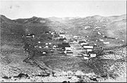
Skidoo, California
Skidoo is an unincorporated community in Inyo County, California. It lies at an elevation of 5689 feet . Skidoo is a virtual ghost town located in Death Valley National Park. It is on the National Register of Historic Places...
. In the Death Valley area these solidified blobs of magma are located under much of the Owlshead Mountains
Owlshead Mountains
The Owlshead Mountains are located at the southern end of Death Valley National Park near the border of the Fort Irwin Military Reservation in San Bernardino County, California, USA.-Geography:...
and are found in the western end of the Panamint Mountains. Thrusted areas can be seen at Schwaub Peak in the southern part of the Funeral Mountains.
A long period of uplift and erosion was concurrent with and followed the above events, creating a major unconformity. Sediments worn off the Death Valley region were shed both east and west and carried by wind and water; the eastern sediments ended up in Colorado
Colorado
Colorado is a U.S. state that encompasses much of the Rocky Mountains as well as the northeastern portion of the Colorado Plateau and the western edge of the Great Plains...
and are now famous for their dinosaur
Dinosaur
Dinosaurs are a diverse group of animals of the clade and superorder Dinosauria. They were the dominant terrestrial vertebrates for over 160 million years, from the late Triassic period until the end of the Cretaceous , when the Cretaceous–Paleogene extinction event led to the extinction of...
fossils. No Jurassic to Eocene
Eocene
The Eocene Epoch, lasting from about 56 to 34 million years ago , is a major division of the geologic timescale and the second epoch of the Paleogene Period in the Cenozoic Era. The Eocene spans the time from the end of the Palaeocene Epoch to the beginning of the Oligocene Epoch. The start of the...
sedimentary formations exist in the area except for some possibly Jurassic-age volcanic rock
Volcanic rock
Volcanic rock is a rock formed from magma erupted from a volcano. In other words, it is an igneous rock of volcanic origin...
around Butte Valley. Large parts of previously deposited formations were removed; probably by streams that washed the sediment into the Cretaceous Seaway that longitudinally divided North America to the east.
Development of a plain
After 150 million years of volcanism, plutonism, metamorphism, and thrust faulting had run their course, the early part of the Cenozoic era (early Tertiary, 65–30 Ma) was a time of repose; neither igneous nor sedimentary rocks of this age are known here. A relatively featureless plain was created from erosion over many millions of years. Deposition resumed some 35 Ma in the OligoceneOligocene
The Oligocene is a geologic epoch of the Paleogene Period and extends from about 34 million to 23 million years before the present . As with other older geologic periods, the rock beds that define the period are well identified but the exact dates of the start and end of the period are slightly...
epoch on a flood plain that developed in the area; sluggish streams migrated laterally over the surface, laying down cobbles, sand, and mud. Outcrops of the resulting conglomerates
Conglomerate (geology)
A conglomerate is a rock consisting of individual clasts within a finer-grained matrix that have become cemented together. Conglomerates are sedimentary rocks consisting of rounded fragments and are thus differentiated from breccias, which consist of angular clasts...
, sandstone, and mudstone of the Titus Canyon Formation can be observed in road cuts at Daylight Pass on Daylight Pass Road, which becomes State Route 374
Nevada State Route 374
State Route 374 is a state highway in Nye County, Nevada, United States. It serves as Nevada's gateway to Death Valley National Park, connecting the park to Beatty...
a short distance from the pass. Several other similar formations were also laid down.
Large volcanic eruptions, originating near the Nevada Test Site
Nevada Test Site
The Nevada National Security Site , previously the Nevada Test Site , is a United States Department of Energy reservation located in southeastern Nye County, Nevada, about northwest of the city of Las Vegas...
, covered the Death Valley area and much of Nevada in thick sequences of silica-rich ash 27 million years ago. The ash has a rhyolitic
Rhyolite
This page is about a volcanic rock. For the ghost town see Rhyolite, Nevada, and for the satellite system, see Rhyolite/Aquacade.Rhyolite is an igneous, volcanic rock, of felsic composition . It may have any texture from glassy to aphanitic to porphyritic...
composition, which is the volcanic equivalent of the plutonic rock granite; it covered what would later become the Grapevine Mountains in 1200 feet (365.8 m) of ash. This ash filled in valleys and depressions; by 20 million years ago, the region from the Death Valley area across Nevada was a volcanic plain.
Extension creates the Basin and Range
Starting around 16 Ma in MioceneMiocene
The Miocene is a geological epoch of the Neogene Period and extends from about . The Miocene was named by Sir Charles Lyell. Its name comes from the Greek words and and means "less recent" because it has 18% fewer modern sea invertebrates than the Pliocene. The Miocene follows the Oligocene...
time and continuing into the present, a large part of the North American Plate
North American Plate
The North American Plate is a tectonic plate covering most of North America, Greenland, Cuba, Bahamas, and parts of Siberia, Japan and Iceland. It extends eastward to the Mid-Atlantic Ridge and westward to the Chersky Range in eastern Siberia. The plate includes both continental and oceanic crust...
in the region has been under extension by literally being pulled apart. Debate still surrounds the cause of this crustal stretching, but an increasingly popular idea among geologists called the slab gap hypothesis
Slab gap hypothesis
In geology, the slab gap hypothesis is one of the explanations put forward to explain several instances of crustal extension that occur inland near former subduction zones....
states that the spreading zone of the subducted Farallon Plate
Farallon Plate
The Farallon Plate was an ancient oceanic plate, which began subducting under the west coast of the North American Plate— then located in modern Utah— as Pangaea broke apart during the Jurassic Period...
is pushing the continent apart. Whatever the cause, the result has been the creation of a large and still-growing region of relatively thin crust; the region grew an average of 1 inches (2.5 cm) per year initially and then slowed to 0.3 inch (0.762 cm) per year in the last 5 million years. Geologists call this region the Basin and Range Province.
Extensional forces causes rock at depth to stretch like silly putty
Silly Putty
Silly Putty , is the Crayola-owned trademark name for a class of silicone polymers. It is marketed today as a toy for children, but was originally created by accident during research into potential rubber substitutes for use by the United States in World War II...
and rock closer to the surface to break along normal faults into downfallen basins called graben
Graben
In geology, a graben is a depressed block of land bordered by parallel faults. Graben is German for ditch. Graben is used for both the singular and plural....
s; small mountain ranges known as horsts run parallel to each other on either side of the graben. Normally the number of horsts and grabens is limited, but in the Basin and Range region there are dozens of horst/graben structures, each roughly north-south trending. A succession of these extend from immediately east of the Sierra Nevada, through almost all of Nevada, and into western Utah and southern Idaho
Idaho
Idaho is a state in the Rocky Mountain area of the United States. The state's largest city and capital is Boise. Residents are called "Idahoans". Idaho was admitted to the Union on July 3, 1890, as the 43rd state....
. The crust in the Death Valley region between Lake Mead
Lake Mead
Lake Mead is the largest reservoir in the United States. It is located on the Colorado River about southeast of Las Vegas, Nevada, in the states of Nevada and Arizona. Formed by water impounded by the Hoover Dam, it extends behind the dam, holding approximately of water.-History:The lake was...
and the southern Sierra Nevada has been extended by as much as 150 miles (241.4 km).
Gravimeter
A gravimeter or gravitometer is an instrument used in gravimetry for measuring the local gravitational field of the Earth. A gravimeter is a type of accelerometer, specialized for measuring the constant downward acceleration of gravity, which varies by about 0.5% over the surface of the Earth...
s show that Death Valley's bedrock floor tilts down toward the east and is deepest under Badwater Basin; there is 9000 feet (2,743.2 m) of fill under Badwater. By about 2 Ma Death Valley
Death Valley
Death Valley is a desert valley located in Eastern California. Situated within the Mojave Desert, it features the lowest, driest, and hottest locations in North America. Badwater, a basin located in Death Valley, is the specific location of the lowest elevation in North America at 282 feet below...
, Panamint Valley
Panamint Valley
The Panamint Valley is a long basin located east of the Argus Range and Slate Range, and west of the Panamint Range in the northeastern reach of the Mojave Desert, in eastern California, United States.-Geography:...
and their associated ranges were formed.
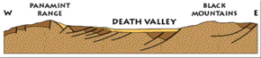
Much of the extra local stretching in Death Valley that is responsible for its lower depth and wider valley floor is caused by left lateral strike-slip movement along the Garlock Fault south of the park (the Garlock Fault separates the Sierra Nevada range from the Mojave Desert
Mojave Desert
The Mojave Desert occupies a significant portion of southeastern California and smaller parts of central California, southern Nevada, southwestern Utah and northwestern Arizona, in the United States...
). This particular fault is pulling the Panamint Range westward, causing the Death Valley graben to slip downward along the Furnace Creek Fault system at the foot of the Black Mountains
Black Mountains (California)
The Black Mountains are located in the southeastern part of Inyo County, California, in southeast Death Valley National Park.-Geography:The Black Mountains are essentially a continuation of the Amargosa Range, and lie in a generally north-south direction at the south-southwest end...
. The rocks that would become the Panamint Range may have been stacked on top of the rocks that would become the Black Mountains and the Cottonwood Mountains. Under this interpretation, as the Black Mountains began to rise, the Panamint/Cottonwood Mountains slid westward off of them along low-angle normal faults, and starting around 6 Ma, the Cottonwood Mountains slid northwest off the top of the Panamint Range. There is also some evidence that the Grapevine Mountains may have slid off the Funeral Mountains. Another interpretation of the evidence is that the Black and Panamint Mountains were once side-by-side and were pulled apart along normal faults. These normal faults, in this view, are steep near the surface but become low angle at depth; the mountain blocks rotated as they slid to create the tilted mountains seen today.
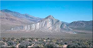
Total movement of the Pamamint block between the Garlock and Furnace Creek Faults is 50 miles (80.5 km) to the northwest, creating Death Valley in the process. A few of the 20 to 25 degree-sloped surfaces along which this mass of 20000 to 30000 ft (6,096 to 9,144 m) of rock slipped, are exposed in Death Valley. These features are called "turtlebacks" due to their turtle shell-like appearance.
Volcanism and valley-fill sedimentation
Cinder cone
According to the , Cinder Cone is the proper name of 1 cinder cone in Canada and 7 cinder cones in the United States:In Canada: Cinder Cone In the United States:...
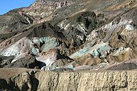
s and lava flows. Some volcanic rocks were re-worked by hydrothermal systems to form colorful rocks and concentrated mineral formations, such as boron
Boron
Boron is the chemical element with atomic number 5 and the chemical symbol B. Boron is a metalloid. Because boron is not produced by stellar nucleosynthesis, it is a low-abundance element in both the solar system and the Earth's crust. However, boron is concentrated on Earth by the...
-rich minerals like borax
Borax
Borax, also known as sodium borate, sodium tetraborate, or disodium tetraborate, is an important boron compound, a mineral, and a salt of boric acid. It is usually a white powder consisting of soft colorless crystals that dissolve easily in water.Borax has a wide variety of uses...
; a Pliocene
Pliocene
The Pliocene Epoch is the period in the geologic timescale that extends from 5.332 million to 2.588 million years before present. It is the second and youngest epoch of the Neogene Period in the Cenozoic Era. The Pliocene follows the Miocene Epoch and is followed by the Pleistocene Epoch...
-aged example is the 4000 feet (1,219.2 m)-thick Artist Drive Formation. Gold and silver ores were also concentrated by mineralizing fluids from igneous intrusions. Other times, heat from magma migrating close to the surface would superheat overlaying groundwater
Groundwater
Groundwater is water located beneath the ground surface in soil pore spaces and in the fractures of rock formations. A unit of rock or an unconsolidated deposit is called an aquifer when it can yield a usable quantity of water. The depth at which soil pore spaces or fractures and voids in rock...
until it exploded, not unlike an exploding pressure-cooker, creating blowout craters and tuff rings. One example of such a feature is the roughly 2000 year old and 800 feet (243.8 m) deep Ubehebe Crater
Ubehebe Crater
Ubehebe Crater is a large volcanic crater of the Ubehebe Craters volcanic field in the northern half of Death Valley, in Death Valley National Park, California.-Geography:...
(photo) in the northern part of the park; nearby smaller craters may be less than 200 to 300 years old.
Sediment filled the subsiding Furnace Creek Basin as the area was pulled apart by Basin and Range extension. The resulting 7000 feet (2,133.6 m)-thick Furnace Creek Formation is made of lakebed sediments that consist of saline muds, gravels from nearby mountains and ash from the then-active Black Mountain volcanic field. Boron, which is abundant in this formation, is dissolved by ground water and flows out onto the northern end of the Death Valley playa. Today this formation is most-prominently exposed in the badlands
Badlands
A badlands is a type of dry terrain where softer sedimentary rocks and clay-rich soils have been extensively eroded by wind and water. It can resemble malpaís, a terrain of volcanic rock. Canyons, ravines, gullies, hoodoos and other such geological forms are common in badlands. They are often...
at Zabriskie Point
Zabriskie Point
Zabriskie Point is a part of Amargosa Range located in east of Death Valley in Death Valley National Park in the United States noted for its erosional landscape...
. Additional subsidence of the Furnace Creek Basin was filled by the four-million-year-old Funeral Formation, which consists of 2000 feet (609.6 m) of conglomerates, sand, mud and volcanic material. Another smaller basin to the south was filled by the Copper Canyon Formation around the same time. Footprints and fossils of camels, horses, and mammoths are in all three of these Pliocene formations.
About 2–3 Ma, in the Pleistocene
Pleistocene
The Pleistocene is the epoch from 2,588,000 to 11,700 years BP that spans the world's recent period of repeated glaciations. The name pleistocene is derived from the Greek and ....
, continental ice sheets expanded from the polar regions of the globe to cover lower latitudes far north of the region, starting a series of cold glacial period
Glacial period
A glacial period is an interval of time within an ice age that is marked by colder temperatures and glacier advances. Interglacials, on the other hand, are periods of warmer climate within an ice age...
s that were interrupted by warmer interglacial periods. Snowmelt from alpine glacier
Glacier
A glacier is a large persistent body of ice that forms where the accumulation of snow exceeds its ablation over many years, often centuries. At least 0.1 km² in area and 50 m thick, but often much larger, a glacier slowly deforms and flows due to stresses induced by its weight...
s on the nearby Sierra Nevada during glacial periods fed rivers that flowed into the valleys of the region year round. Since the topography of the Basin and Range region was largely formed by faulting, not by river erosion, many of the basins have no outlets, meaning they will fill up with water like a bathtub until they overflow into the next basin. So during the cooler and wetter pluvial climates of the glacial periods, much of eastern California
Eastern California
Eastern California is a term that refers to the eastern region of California, United States. It can refer to either the strip to the east of the crest of the Sierra Nevada, or to the easternmost counties of California.-Culture and history:...
, all of Nevada, and western Utah were covered by large lakes separated by linear islands (the present day ranges).
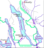
Lake Manly
Lake Manly is a pluvial, former freshwater, endorheic, rift lake that filled the Death Valley basin of Inyo County, California through the Holocene before the area's climate changed to desert. Following its isolation from the Colorado River system, Lake Manly receded by evaporation with Badwater...
was the lake that filled Death Valley during each glacial period from at least 240,000 years ago to as late as 10,500 years ago; the lake typically dried up during each interglacial period, such as the current one. Lake Manly was the last in a chain of lakes that were fed by the Amargosa
Amargosa River
The Amargosa River is an intermittent waterway, long, in southern Nevada and eastern California in the United States. It drains a high desert region, the Amargosa Valley in the Amargosa Desert northwest of Las Vegas, into the Mojave Desert, and finally into Death Valley where it disappears into...
and Mojave River
Mojave River
The Mojave River is an intermittent river in the eastern San Bernardino Mountains and Mojave Desert in San Bernardino County, California. The river is notable as most of its flow is underground, while its surface channels remain dry most of the time, with the exception of the headwaters and several...
s, and possibly also the Owens River
Owens River
The Owens River is a river in southeastern California in the United States, approximately long. It drains into and through the Owens Valley, an arid basin between the eastern slope of the Sierra Nevada and the western faces of the Inyo and White Mountains. The river terminates at Owens Lake, but...
; it was also the lowest point in the Great Basin
Great Basin
The Great Basin is the largest area of contiguous endorheic watersheds in North America and is noted for its arid conditions and Basin and Range topography that varies from the North American low point at Badwater Basin to the highest point of the contiguous United States, less than away at the...
drainage system. At its height during the Last glacial period some 22,000 years ago, water filled Lake Manly to form a body of water that may have been 585 feet (178.3 m) deep and 90 miles (144.8 km) long. Much smaller lakes filled parts of Death Valley during interglacials; the largest of these was 30 feet (9.1 m) deep and lasted from 5000 to 2000 years ago. Panamint Lake filled Panamint Valley to a maximum depth of 900 feet (274.3 m); when it was full, Panamint Lake overflowed into Lake Manly somewhere around the southern end of the Panamint Mountains.
Lake Manly and its sister lakes started to dry up about 10,000 years ago as the alpine glaciers that fed the rivers that filled the lakes disappeared and the region became increasingly arid. Fish that had migrated into the lake system from the Colorado River
Colorado River
The Colorado River , is a river in the Southwestern United States and northwestern Mexico, approximately long, draining a part of the arid regions on the western slope of the Rocky Mountains. The watershed of the Colorado River covers in parts of seven U.S. states and two Mexican states...
started to die off; the only survivors are the minnow-sized Death Valley pupfish
Death Valley pupfish
The Death Valley pupfish, Cyprinodon salinus salinus, is found in Death Valley National Park.-Description:The Death Valley pupfish is a species of fish that is the last known survivor of what is thought to have been a large ecosystem of fish species that lived in Lake Manly, which dried up at the...
and related species that adapted to living in springs. Ancient weak shorelines called strandlines from Lake Manly can easily be seen on a former island in the lake called Shoreline Butte.
Stream gradient
Stream gradient
Stream gradient is the grade measured by the ratio of drop in a stream per unit distance, usually expressed as feet per mile or metres per kilometre.-Hydrology and geology:A high gradient indicates a steep slope and rapid flow of water Stream gradient is the grade (slope) measured by the ratio of...
s increased on flanking mountain ranges as they were uplifted. These swifter moving streams are dry most of the year but have nevertheless cut true river valleys, canyons, and gorges that face Death and Panamint valleys. In this arid environment, alluvial fan
Alluvial fan
An alluvial fan is a fan-shaped deposit formed where a fast flowing stream flattens, slows, and spreads typically at the exit of a canyon onto a flatter plain. A convergence of neighboring alluvial fans into a single apron of deposits against a slope is called a bajada, or compound alluvial...
s form at the mouth of these streams. Very large alluvial fans merged to form continuous alluvial slopes called bajadas along the Panamint Range. The faster uplift along the Black Mountains formed much smaller alluvial fans because older fans are buried under playa sediments before they can grow too large. Slot canyon
Slot canyon
A slot canyon is a narrow canyon, formed by the wear of water rushing through rock. A slot canyon is significantly deeper than it is wide. Some slot canyons can measure less than one metre across at the top but drop more than 30 m to the floor of the canyon.Most slot canyons are formed in...
s are often found at the mouths of the streams that feed the fans, and the slot canyons in turn are topped by V-shaped gorges. This forms what looks like a wineglass shape to some people, thus giving them their names, "wineglass canyons".
Table of formations
This table of formations exposed in the Death Valley area lists and describes the exposed formations of the Death Valley National ParkDeath Valley National Park
Death Valley National Park is a national park in the U.S. states of California and Nevada located east of the Sierra Nevada in the arid Great Basin of the United States. The park protects the northwest corner of the Mojave Desert and contains a diverse desert environment of salt-flats, sand dunes,...
and the surrounding area.
| System | Series | Formation | Lithology and thickness | Characteristic fossils |
|---|---|---|---|---|
| Quaternary Quaternary The Quaternary Period is the most recent of the three periods of the Cenozoic Era in the geologic time scale of the ICS. It follows the Neogene Period, spanning 2.588 ± 0.005 million years ago to the present... |
Holocene Holocene The Holocene is a geological epoch which began at the end of the Pleistocene and continues to the present. The Holocene is part of the Quaternary period. Its name comes from the Greek words and , meaning "entirely recent"... |
Fan gravel Gravel Gravel is composed of unconsolidated rock fragments that have a general particle size range and include size classes from granule- to boulder-sized fragments. Gravel can be sub-categorized into granule and cobble... ; silt Silt Silt is granular material of a size somewhere between sand and clay whose mineral origin is quartz and feldspar. Silt may occur as a soil or as suspended sediment in a surface water body... and salt Salt In chemistry, salts are ionic compounds that result from the neutralization reaction of an acid and a base. They are composed of cations and anions so that the product is electrically neutral... on floor of playa Dry lake Dry lakes are ephemeral lakebeds, or a remnant of an endorheic lake. Such flats consist of fine-grained sediments infused with alkali salts. Dry lakes are also referred to as alkali flats, sabkhas, playas or mud flats... , less than 100 feet (30.5 m) thick. |
None | |
| Pleistocene Pleistocene The Pleistocene is the epoch from 2,588,000 to 11,700 years BP that spans the world's recent period of repeated glaciations. The name pleistocene is derived from the Greek and .... |
Fan gravel; silt and salt buried under floor of playa; perhaps 2000 feet (609.6 m) thick. | |||
| Funeral fanglomerate | Cemented fan gravel with interbedded basalt Basalt Basalt is a common extrusive volcanic rock. It is usually grey to black and fine-grained due to rapid cooling of lava at the surface of a planet. It may be porphyritic containing larger crystals in a fine matrix, or vesicular, or frothy scoria. Unweathered basalt is black or grey... ic lava Lava Lava refers both to molten rock expelled by a volcano during an eruption and the resulting rock after solidification and cooling. This molten rock is formed in the interior of some planets, including Earth, and some of their satellites. When first erupted from a volcanic vent, lava is a liquid at... s, gravels cut by veins of calcite Calcite Calcite is a carbonate mineral and the most stable polymorph of calcium carbonate . The other polymorphs are the minerals aragonite and vaterite. Aragonite will change to calcite at 380-470°C, and vaterite is even less stable.-Properties:... (Mexican onyx); perhaps 1000 feet (304.8 m) thick. |
Diatom Diatom Diatoms are a major group of algae, and are one of the most common types of phytoplankton. Most diatoms are unicellular, although they can exist as colonies in the shape of filaments or ribbons , fans , zigzags , or stellate colonies . Diatoms are producers within the food chain... s, pollen Pollen Pollen is a fine to coarse powder containing the microgametophytes of seed plants, which produce the male gametes . Pollen grains have a hard coat that protects the sperm cells during the process of their movement from the stamens to the pistil of flowering plants or from the male cone to the... . |
||
| Tertiary Tertiary The Tertiary is a deprecated term for a geologic period 65 million to 2.6 million years ago. The Tertiary covered the time span between the superseded Secondary period and the Quaternary... |
Pliocene Pliocene The Pliocene Epoch is the period in the geologic timescale that extends from 5.332 million to 2.588 million years before present. It is the second and youngest epoch of the Neogene Period in the Cenozoic Era. The Pliocene follows the Miocene Epoch and is followed by the Pleistocene Epoch... |
Furnace Creek Formation | Cement Cement In the most general sense of the word, a cement is a binder, a substance that sets and hardens independently, and can bind other materials together. The word "cement" traces to the Romans, who used the term opus caementicium to describe masonry resembling modern concrete that was made from crushed... ed gravel, silty and saliferous playa deposits; various salts, especially borate Borate Borates are chemical compounds which contain oxoanions of boron in oxidation state +3. The simplest borate ion, BO33−, has a trigonal planar structure. Other borates are made up of trigonal BO3 or tetrahedral BO4 structural units, sharing oxygen atoms... s, more than 5000 feet (1,524 m) thick. |
Scarce. |
| Miocene Miocene The Miocene is a geological epoch of the Neogene Period and extends from about . The Miocene was named by Sir Charles Lyell. Its name comes from the Greek words and and means "less recent" because it has 18% fewer modern sea invertebrates than the Pliocene. The Miocene follows the Oligocene... |
Artist Drive Formation | Cemented gravel; playa deposits, much volcanic Volcano 2. Bedrock3. Conduit 4. Base5. Sill6. Dike7. Layers of ash emitted by the volcano8. Flank| 9. Layers of lava emitted by the volcano10. Throat11. Parasitic cone12. Lava flow13. Vent14. Crater15... debris, perhaps 5000 feet (1,524 m) thick. |
Scarce. | |
| Oligocene Oligocene The Oligocene is a geologic epoch of the Paleogene Period and extends from about 34 million to 23 million years before the present . As with other older geologic periods, the rock beds that define the period are well identified but the exact dates of the start and end of the period are slightly... |
Titus Canyon Formation | Cemented gravel; mostly stream Stream A stream is a body of water with a current, confined within a bed and stream banks. Depending on its locale or certain characteristics, a stream may be referred to as a branch, brook, beck, burn, creek, "crick", gill , kill, lick, rill, river, syke, bayou, rivulet, streamage, wash, run or... deposits; 3000 feet (914.4 m) thick. |
Vertebrate Vertebrate Vertebrates are animals that are members of the subphylum Vertebrata . Vertebrates are the largest group of chordates, with currently about 58,000 species described. Vertebrates include the jawless fishes, bony fishes, sharks and rays, amphibians, reptiles, mammals, and birds... s, titanotheres, etc. |
|
| Eocene Eocene The Eocene Epoch, lasting from about 56 to 34 million years ago , is a major division of the geologic timescale and the second epoch of the Paleogene Period in the Cenozoic Era. The Eocene spans the time from the end of the Palaeocene Epoch to the beginning of the Oligocene Epoch. The start of the... and Paleocene Paleocene The Paleocene or Palaeocene, the "early recent", is a geologic epoch that lasted from about . It is the first epoch of the Palaeogene Period in the modern Cenozoic Era... |
Granitic Granite Granite is a common and widely occurring type of intrusive, felsic, igneous rock. Granite usually has a medium- to coarse-grained texture. Occasionally some individual crystals are larger than the groundmass, in which case the texture is known as porphyritic. A granitic rock with a porphyritic... intrusions and volcanics, not known to be represented by sedimentary deposits. |
|||
| Cretaceous Cretaceous The Cretaceous , derived from the Latin "creta" , usually abbreviated K for its German translation Kreide , is a geologic period and system from circa to million years ago. In the geologic timescale, the Cretaceous follows the Jurassic period and is followed by the Paleogene period of the... and Jurassic Jurassic The Jurassic is a geologic period and system that extends from about Mya to Mya, that is, from the end of the Triassic to the beginning of the Cretaceous. The Jurassic constitutes the middle period of the Mesozoic era, also known as the age of reptiles. The start of the period is marked by... |
Not represented, area was being eroded. | |||
| Triassic Triassic The Triassic is a geologic period and system that extends from about 250 to 200 Mya . As the first period of the Mesozoic Era, the Triassic follows the Permian and is followed by the Jurassic. Both the start and end of the Triassic are marked by major extinction events... |
Butte Valley Formation of Johnson (1957) | Exposed in Butte Valley 1 miles (1.6 km) south of this area; 8000 feet (2,438.4 m) of metasediments and volcanics. | Ammonites, smooth-shelled brachiopod Brachiopod Brachiopods are a phylum of marine animals that have hard "valves" on the upper and lower surfaces, unlike the left and right arrangement in bivalve molluscs. Brachiopod valves are hinged at the rear end, while the front can be opened for feeding or closed for protection... s, belemnites, and hexacorals. |
|
| Pennsylvanian Pennsylvanian The Pennsylvanian is, in the ICS geologic timescale, the younger of two subperiods of the Carboniferous Period. It lasted from roughly . As with most other geochronologic units, the rock beds that define the Pennsylvanian are well identified, but the exact date of the start and end are uncertain... and Permian Permian The PermianThe term "Permian" was introduced into geology in 1841 by Sir Sir R. I. Murchison, president of the Geological Society of London, who identified typical strata in extensive Russian explorations undertaken with Edouard de Verneuil; Murchison asserted in 1841 that he named his "Permian... |
Formations at east foot of Tucki Mountain | Conglomerate Conglomerate (geology) A conglomerate is a rock consisting of individual clasts within a finer-grained matrix that have become cemented together. Conglomerates are sedimentary rocks consisting of rounded fragments and are thus differentiated from breccias, which consist of angular clasts... , limestone Limestone Limestone is a sedimentary rock composed largely of the minerals calcite and aragonite, which are different crystal forms of calcium carbonate . Many limestones are composed from skeletal fragments of marine organisms such as coral or foraminifera.... , and some shale Shale Shale is a fine-grained, clastic sedimentary rock composed of mud that is a mix of flakes of clay minerals and tiny fragments of other minerals, especially quartz and calcite. The ratio of clay to other minerals is variable. Shale is characterized by breaks along thin laminae or parallel layering... . Conglomerate contains cobbles of limestone of Mississippian, Pennsylvanian, and Permian age. Limestone and shale contain spherical chert Chert Chert is a fine-grained silica-rich microcrystalline, cryptocrystalline or microfibrous sedimentary rock that may contain small fossils. It varies greatly in color , but most often manifests as gray, brown, grayish brown and light green to rusty red; its color is an expression of trace elements... nodules. Abundant fusulinids. Thickness uncertain on account of faulting; estimate 3000 feet (914.4 m), top eroded. |
Beds with fusulinid Fusulinid The Fusulinida is an extinct order within the Foraminifera in which the tests are composed of tightly packed, secreted microgranular calcite. In advanced forms the test wall is differentiated into two or more layers... s, especially Fusulinella |
|
| Carboniferous Carboniferous The Carboniferous is a geologic period and system that extends from the end of the Devonian Period, about 359.2 ± 2.5 Mya , to the beginning of the Permian Period, about 299.0 ± 0.8 Mya . The name is derived from the Latin word for coal, carbo. Carboniferous means "coal-bearing"... |
Mississippian and Pennsylvanian Pennsylvanian The Pennsylvanian is, in the ICS geologic timescale, the younger of two subperiods of the Carboniferous Period. It lasted from roughly . As with most other geochronologic units, the rock beds that define the Pennsylvanian are well identified, but the exact date of the start and end are uncertain... |
Rest Spring Shale | Mostly shale, some limestone, abundant spherical chert nodules. Thickness uncertain because of faulting; estimate 750 feet (228.6 m). | None. |
| Mississippian | Tin Mountain Limestone and younger limestone | Mapped as 1 unit. Tin Mountain Limestone 1000 feet (304.8 m) thick, is black with thin-bedded lower member and thick-bedded upper member. Unnamed limestone formation, 725 feet (221 m) thick, consists of interbedded chert and limestone in thin beds and in about equal proportions. | Mixed brachiopods, coral Coral Corals are marine animals in class Anthozoa of phylum Cnidaria typically living in compact colonies of many identical individual "polyps". The group includes the important reef builders that inhabit tropical oceans and secrete calcium carbonate to form a hard skeleton.A coral "head" is a colony of... s, and crinoid Crinoid Crinoids are marine animals that make up the class Crinoidea of the echinoderms . Crinoidea comes from the Greek word krinon, "a lily", and eidos, "form". They live both in shallow water and in depths as great as 6,000 meters. Sea lilies refer to the crinoids which, in their adult form, are... stems. Syringopora (open-spaced colonies) Caninia cf. C. cornicula. |
|
| Devonian Devonian The Devonian is a geologic period and system of the Paleozoic Era spanning from the end of the Silurian Period, about 416.0 ± 2.8 Mya , to the beginning of the Carboniferous Period, about 359.2 ± 2.5 Mya... |
Middle and Upper Devonian | Lost Burro Formation | Limestone in light and dark beds 1 to 10 ft (0.3048 to 3 m) thick give striped effect on mountainsides. Two quartzite beds, each about 3 foot (0.9144 m) thick, near base, numerous sandstone beds 800 to 1000 ft (243.8 to 304.8 m) above base. Top 200 feet (61 m) is well-bedded limestone and quartzite Quartzite Quartzite is a hard metamorphic rock which was originally sandstone. Sandstone is converted into quartzite through heating and pressure usually related to tectonic compression within orogenic belts. Pure quartzite is usually white to gray, though quartzites often occur in various shades of pink... . Total thickness uncertain because of faulting; estimated 2000 feet (609.6 m). |
Brachiopods abundant, especially Spirifer, Cyrtospirifer, Productilla, Carmarotoechia, Atrypa Atrypa Atrypa also known as lamp shell is an extinct genus of brachiopod that lived from the Late Ordovician to the Carboniferous and occurs abundantly as fossils in marine rocks... . Stromatoporoids. Syringopora (closely spaced colonies). |
| Silurian Silurian The Silurian is a geologic period and system that extends from the end of the Ordovician Period, about 443.7 ± 1.5 Mya , to the beginning of the Devonian Period, about 416.0 ± 2.8 Mya . As with other geologic periods, the rock beds that define the period's start and end are well identified, but the... and Devonian Devonian The Devonian is a geologic period and system of the Paleozoic Era spanning from the end of the Silurian Period, about 416.0 ± 2.8 Mya , to the beginning of the Carboniferous Period, about 359.2 ± 2.5 Mya... |
Silurian and Lower Devonian | Hidden Valley Dolomite | Thick-bedded, fine-grained, and even-grained dolomite, mostly light color. Thickness 300 to 1400 ft (91.4 to 426.7 m). | Crinoid stems abundant, Including large types. Favosites Favosites Favosites is an extinct genus of tabulate coral characterized by polygonal closely packed corallites . The walls between corallites are pierced by pores which allowed transfer of nutrients between polyps.... . |
| Ordovician Ordovician The Ordovician is a geologic period and system, the second of six of the Paleozoic Era, and covers the time between 488.3±1.7 to 443.7±1.5 million years ago . It follows the Cambrian Period and is followed by the Silurian Period... |
Upper Ordovician | Ely Springs Dolomite | Massive black dolomite, 400 to 800 ft (121.9 to 243.8 m) thick. | Streptelasmatid corals: Grewingkia, Bighornia. Brachiopods. |
| Middle and Upper (?) Ordovician | Eureka Quartzite | Massive quartzite, with thin-bedded quartzite at base and top, 350 feet (106.7 m) thick. | None | |
| Lower and Middle Ordovician | Pogonip Group | Dolomite, with some limestone, at base, shale unit in middle, massive dolomite at top. Thickness, 1500 feet (457.2 m). | Abundant large gastropods in massive dolomite at top: Palliseria and Maclurites, associated with Receptaculites Receptaculites Receptaculites was probably a benthic marine calcareous alga of the Order Dasycladales that lived from the Early Ordovician through the Permian. It has a double spiral radiating pattern of rhombus-shaped plates supported by spindle-like objects called meroms... . In lower beds: Protopliomerops, Kirkella, Orthid brachiopods. |
|
| Cambrian Cambrian The Cambrian is the first geological period of the Paleozoic Era, lasting from Mya ; it is succeeded by the Ordovician. Its subdivisions, and indeed its base, are somewhat in flux. The period was established by Adam Sedgwick, who named it after Cambria, the Latin name for Wales, where Britain's... |
Upper Cambrian | Nopah Formation | Highly fossiliferous shale member 100 feet (30.5 m) thick at base, upper 1200 feet (365.8 m) is dolomite in thick alternating black and light hands about 100 feet (30.5 m) thick. Total thickness of formation 1200 to 1500 ft (365.8 to 457.2 m). | In upper part, gastropods. In basal 100 feet (30.5 m), trilobite Trilobite Trilobites are a well-known fossil group of extinct marine arthropods that form the class Trilobita. The first appearance of trilobites in the fossil record defines the base of the Atdabanian stage of the Early Cambrian period , and they flourished throughout the lower Paleozoic era before... trash beds containing Elburgis, Pseudagnostus, Horriagnostris, Elvinia, Apsotreta. |
| Middle and Upper Cambrian | Bonanza King Formation | Mostly thick-bedded arid massive dark-colored dolomite, thin-bedded limestone member 500 feet (152.4 m) thick 1000 feet (304.8 m) below top of formation, 2 brown-weathering shaIy units, upper one fossiliferous, Total thickness Uncertain because of faulting; estimated about 3000 feet (914.4 m) in Panamint Range, 2000 feet (609.6 m) in Funeral Mountains. | The only fossiliferous bed is shale below limestone member neat middle of formation. This shale contains linguloid brachiopods and trilobite trash beds with fragments of "Ehmaniella Ehmaniella Ehmaniella is a genus of trilobite known from the Middle Cambrian Burgess Shale. Its major characteristics are a wide cranidium, heavy eye ridges, longitudinal striae on the pre-glabellar area, and a small pygidium with few segments.... ." |
|
| Lower and Middle Cambrian Cambrian The Cambrian is the first geological period of the Paleozoic Era, lasting from Mya ; it is succeeded by the Ordovician. Its subdivisions, and indeed its base, are somewhat in flux. The period was established by Adam Sedgwick, who named it after Cambria, the Latin name for Wales, where Britain's... |
Carrara Formation | An alternation of shaly and silty members with limestone members transitional between underlying clastic formations and overlying carbonate ones. Thickness about 1000 feet (304.8 m) but variable because of shearing. | Numerous trilobite trash beds in lower part yield fragments of olenellid trilobites. | |
| Lower Cambrian | Zabriskie Quartzite | Quartzite, mostly massive arid granulated due to shearing, locally it) beds 6 inches (15.2 cm) to 2 foot (0.6096 m) thick. Thickness more than 150 feet (45.7 m), variable because of shearing. | No fossils. | |
| Lower Cambrian and Lower Cambrian (?) | Wood Canyon Formation | Basal unit is well-bedded quartzite above 1650 feet (502.9 m) thick ' shaly Unit above this 520 feet (158.5 m) thick contains lowest olenellids in section; top unit of dolomite and quartzite 400 feet (121.9 m) thick. | A few scattered olenellid trilobites and archaeocyathids in upper part of formation. Scolithus? tubes. | |
| Stirling Quartzite | Well-bedded quartzite in beds 1 to 5 ft (0.3048 to 1.5 m) thick comprising thick members of quartzite 700 to 800 ft (213.4 to 243.8 m) thick separated by 500 feet (152.4 m) of purple shale, crossbedding conspicuous in quartzite. Maximum thickness about 2000 feet (609.6 m). | None. | ||
| Johnnie Formation | Mostly shale, in part olive brown, in part purple. Basal member 400 feet (121.9 m) thick is interbedded dolomite arid quartzite with pebble conglomerate. Locally, fair dolomite near middle arid at top. Thickness more than 4000 feet (1,219.2 m). | None. | ||
| Precambrian Precambrian The Precambrian is the name which describes the large span of time in Earth's history before the current Phanerozoic Eon, and is a Supereon divided into several eons of the geologic time scale... |
Noonday Dolomite | In southern Panamint Range, dolomite in Indistinct beds; lower part cream colored, upper part gray. Thickness 800 feet (243.8 m). Farther north, where mapped as Noonday(?) Dolomite, contains much limestone, tan and white, and some limestone conglomerate. Thickness about 1000 feet (304.8 m). | Scolithus? tubes. | |
| Unconformity | ||||
| Kingston Peak(?) Formation | Mostly conglomerate, quartzite, and shale; some limestone arid dolomite near middle. At least 3000 feet (914.4 m) thick. Although tentatively assigned to Kingston Peak Formation, similar rocks along west side of Panamint Range have been identified as Kingston Peak. | None. | ||
| Beck Spring Dolomite | Not mapped; outcrops are to the west. Blue-gray cherry dolomite, thickness estimated about 500 feet (152.4 m) Identification uncertain. | None. | ||
| Pahrump Series | Crystal Spring Formation | Recognized only in Galena Canyon and south. Total thickness about 2000 feet (609.6 m). Consists of basal conglomerate overlain by quartzite that grades upward into purple shale arid thinly bedded dolomite, upper part, thick bedded dolomite, diabase, and chert. Talc Talc Talc is a mineral composed of hydrated magnesium silicate with the chemical formula H2Mg34 or Mg3Si4O102. In loose form, it is the widely-used substance known as talcum powder. It occurs as foliated to fibrous masses, its crystals being so rare as to be almost unknown... deposits where diabase intrudes dolomite. |
None. | |
| Unconformity | ||||
| Rocks of the crystalline basement | Metasedimentary rocks with granitic intrusions. | None. |
Table of salts
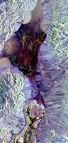
| Mineral | Composition | Known or probable occurrence |
|---|---|---|
| Halite Halite Halite , commonly known as rock salt, is the mineral form of sodium chloride . Halite forms isometric crystals. The mineral is typically colorless or white, but may also be light blue, dark blue, purple, pink, red, orange, yellow or gray depending on the amount and type of impurities... |
NaCl | Principal constituent of chloride zone and of salt-impregnated sulfate and carbonate deposits. |
| Sylvite Sylvite Sylvite is potassium chloride in natural mineral form. It forms crystals in the isometric system very similar to normal rock salt, halite . The two are, in fact, isomorphous. Sylvite is colorless to white with shades of yellow and red due to inclusions. It has a Mohs hardness of 2.5 and a specific... |
KCl | With halite. |
| Trona Trona Trona ; Na3•2H2O is an evaporite mineral. It is mined as the primary source of sodium carbonate in the United States, where it has replaced the Solvay process used in most of the rest of the world for sodium carbonate production.- Etymology :The word "trona" comes to English by way of either... |
Na3H(CO3)22H2O | Carbonate zone of Cottonball Basin, especially in marshes. |
| Thermonatrite Thermonatrite Thermonatrite is a naturally occurring evaporite mineral form of sodium carbonate, Na2CO3·.It was first described in 1845. Its name is from the Greek θερμός, "thermos", heat, plus natron, because it may be a dehydration product of natron.... |
Na2CO3·H2O | Questionably present on floodplain in Badwater Basin, would be expected in marshes of carbonate zone in Cottonball Basin. |
| Gaylussite Gaylussite Gaylussite is a carbonate mineral, a hydrated sodium calcium carbonate, formula Na2Ca2·5H2O. It occurs as translucent, vitreous white to grey to yellow monoclinic prismatic crystals. It is an unstable mineral which dehydrates in dry air and decomposes in water.It is formed as an evaporite from... |
Na2Ca(CO3)2·5H2O | Carbonate zone and floodplain in Badwater Basin. |
| Calcite Calcite Calcite is a carbonate mineral and the most stable polymorph of calcium carbonate . The other polymorphs are the minerals aragonite and vaterite. Aragonite will change to calcite at 380-470°C, and vaterite is even less stable.-Properties:... |
CaCO3 | Occurs as clastic grains in sediments underlying salt pan and as sharply terminated crystals in clay fraction of carbonate zone and in sediments underlying sulfate zone. |
| Magnesite Magnesite Magnesite is magnesium carbonate, MgCO3. Iron substitutes for magnesium with a complete solution series with siderite, FeCO3. Calcium, manganese, cobalt, and nickel may also occur in small amounts... |
MgCO3 | Obtained in artificially evaporated brines from Death Valley; not yet identified in salt pan; may be expected in carbonate zone of Cottonball Basin. |
| Dolomite Dolomite Dolomite is a carbonate mineral composed of calcium magnesium carbonate CaMg2. The term is also used to describe the sedimentary carbonate rock dolostone.... |
CaMg(CO3)2 | identified only as a detrital mineral; may be expected in carbonate zone. |
| Northupite Northupite Northupite is an uncommon evaporite mineral, with the chemical formula Na3Mg2Cl. It was discovered in 1895 at Searles Lake, San Bernardino County, California by C. H. Northup , a grocer from San Jose, California, for whom Northupite is named.... and/or tychite |
Na3MgCl(CO3) and/or Na6Mg2(SO4)·(CO3)4 | An isotropic mineral, having index of refraction in the range of Northupite and Tychite, has been observed in saline facies of sulfate zone in Cottonball Basin. |
| Burkeite | Na6(CO3)(SO4)2 | Sulfate zone in Cottonball Basin. |
| Thenardite Thenardite Thenardite is an anhydrous sodium sulfate mineral, Na2SO4 which occurs in arid evaporite environments. It also occurs in dry caves and old mine workings as an efflorescence and as a crusty deposit around fumaroles. It occurs in volcanic caves on Mt... |
Na2SO4 | Common in all zones in Cottonball Basin and in sulfate marshes in Middle and Badwater basins. |
| Mirabilite Mirabilite Mirabilite, also known as Glauber's salt, is a hydrous sodium sulfate mineral with the chemical formula Na2SO4·10H2O. It is a vitreous, colorless to white monoclinic mineral which forms as an evaporite from sodium sulfate bearing brines. It is found around saline springs and along saline playa lakes... |
Na2SO4·10H2O | Occurs on floodplains in Cottonball Basin immediately following winter storms. |
| Glauberite Glauberite Glauberite is a sodium calcium sulfate mineral with the formula Na2Ca2, which forms as an evaporite. It is named for the closely related Glauber's salts. Because of its solubility, glauberite is often dissolved away from the crystal matrix leaving a mould into which other minerals are deposited... |
Na2Ca(SO4)2 | Common on floodplains except in central part of Badwater Basin; sulfate zone in Cottonball Basin. |
| Anhydrite Anhydrite Anhydrite is a mineral – anhydrous calcium sulfate, CaSO4. It is in the orthorhombic crystal system, with three directions of perfect cleavage parallel to the three planes of symmetry. It is not isomorphous with the orthorhombic barium and strontium sulfates, as might be expected from the... |
CaSO4 | As layer capping massive gypsum 1 mile (2 km) north of Badwater. Possibly also as dry-period efflorescence on floodplains. |
| Bassanite | 2CaSO4·H2O | As layer capping massive gypsum along west side of Badwater Basin and as dry-period efflorescence in floodplains. |
| Gypsum Gypsum Gypsum is a very soft sulfate mineral composed of calcium sulfate dihydrate, with the chemical formula CaSO4·2H2O. It is found in alabaster, a decorative stone used in Ancient Egypt. It is the second softest mineral on the Mohs Hardness Scale... |
CaSO4·2H2O | In sulfate caliche, layer in carbonate zone, particularly in Middle and Badwater basins, in sulfate marshes and as massive deposits in sulfate zone. |
| Bloedite | Na2Mg(SO4)2·4H2O | Questionably present in efflorescence on floodplain in chloride zone. |
| Polyhalite Polyhalite Polyhalite is an evaporite mineral, a hydrated sulfate of potassium, calcium and magnesium with formula: K2Ca2Mg4·2. Polyhalite crystallizes in the triclinic system although crystals are very rare. The normal habit is massive to fibrous. It is typically colorless, white to gray, although it... |
K2Ca2Mg(SO4)4·2H2O | Questionably present on floodplain in chloride zone. |
| Celestine | SrSO4 | Found with massive gypsum. |
| Kernite Kernite Kernite, also known as rasorite is a hydrated sodium borate hydroxide mineral with formula Na2B4O62·3H2O. It is a colorless to white mineral crystallizing in the monoclinic crystal system typically occurring as prismatic to acicular crystals or granular masses. It is relatively soft with Mohs... |
Na2B4O7·4H2O | Possibly present in Middle Basin in surface layer of layered sulfate and chloride salts. |
| Tincalconite Tincalconite Tincalconite is a hydrous sodium borate mineral closely related to borax, and is a secondary mineral that forms as a dehydration product of borax. Its formula is Na2B4O7·5H2O or Na2[B4O54]·3H2O.Tincalconite typically occurs as a fine grained white powder... |
Na2B4O7·5H2O | Probably occurs as dehydration product of borax. |
| Borax Borax Borax, also known as sodium borate, sodium tetraborate, or disodium tetraborate, is an important boron compound, a mineral, and a salt of boric acid. It is usually a white powder consisting of soft colorless crystals that dissolve easily in water.Borax has a wide variety of uses... |
Na2B4O7·10H2O | Floodplains and marshes in Cottonball Basin. |
| Inyoite Inyoite Inyoite, named after Inyo County, California, where it was discovered in 1914, is a colourless monoclinic mineral. It turns white on dehydration. Its chemical formula is Ca·4 or CaB3O35·4.... |
Ca2B6O11·13H2O | Questionably present (X-ray determination but unsatisfactory) in floodplain in Badwater Basin. |
| Meyerhofferite Meyerhofferite Meyerhofferite is a hydrated borate mineral, with the chemical formula Ca2B6O610·2, CaB3O35·H2O or Ca22·4. It occurs principally as an alteration product of inyoite, another borate mineral.... |
Ca2B6O11·7H2O | Found in all zones in Badwater Basin and in rough silty rock salt in Cottonball Basin |
| Colemanite Colemanite Colemanite is a borate mineral found in evaporite deposits of alkaline lacustrine environments. Colemanite is a secondary mineral that forms by alteration of borax and ulexite.... |
Ca2B6O11·5H2O | Questionably present (X-ray determination but unsatisfactory) in floodplain in Badwater Basin. |
| Ulexite Ulexite Ulexite , sometimes known as TV rock, is a mineral occurring in silky white rounded crystalline masses or in parallel fibers. The natural fibers of ulexite conduct light along their long axes, by internal reflection... |
NaCaB5O9·8H2O | Common in floodplain in Cottonball Basin; known as "cottonball" |
| Proberite | NaCaB5O9·5H2O | A fibrous borate with index of refraction higher than ulexite occurs on dry areas in Cottonball Basin following hot dry spells and in surface layer of smooth silty rock salt. |
| Soda niter | NaNO3 | Weak, but positive chemical tests obtained locally. |
See also
- Places of interest in the Death Valley areaPlaces of interest in the Death Valley areaPlaces of interest in the Death Valley area are mostly located within Death Valley National Park in eastern California.-Artist's Drive and Palette:...
- Category: Death Valley
- Category: Geology of California