
Owlshead Mountains
Encyclopedia
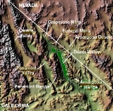
The Owlshead Mountains are located at the southern end of Death Valley National Park
near the border of the Fort Irwin Military Reservation
in San Bernardino County, California
, USA.
, north of the Granite Mountains and the Avawatz Mountains
, south of the Black Mountains
forming the bottom of Death Valley
. The Greenwater Range
is to the northeast, the Slate Range is west, and the Kingston Range
east.
The mean annual precipitation in the range is five inches or less. The Owlshead Mountains are arranged in a semi-circular pattern,
with the Amargosa River
lying to the north.
Death Valley National Park
Death Valley National Park is a national park in the U.S. states of California and Nevada located east of the Sierra Nevada in the arid Great Basin of the United States. The park protects the northwest corner of the Mojave Desert and contains a diverse desert environment of salt-flats, sand dunes,...
near the border of the Fort Irwin Military Reservation
Fort Irwin Military Reservation
Fort Irwin & the National Training Center is a major training area for the United States Military and is a census-designated place located in the Mojave Desert in northern San Bernardino County, California. Fort Irwin sits at an elevation of . The 2010 United States census reported Fort Irwin's...
in San Bernardino County, California
San Bernardino County, California
San Bernardino County is a county in the U.S. state of California. As of the 2010 census, the population was 2,035,210, up from 1,709,434 as of the 2000 census...
, USA.
Geography
The range lies in the Mojave DesertMojave Desert
The Mojave Desert occupies a significant portion of southeastern California and smaller parts of central California, southern Nevada, southwestern Utah and northwestern Arizona, in the United States...
, north of the Granite Mountains and the Avawatz Mountains
Avawatz Mountains
The Avawatz Mountains are located in San Bernardino County in the Mojave Desert of San Bernardino County, California, USA.-Name:The name "Avawatz" is derived from the Mohave Indian term "Avi-Ahwat", or "red rock".-Geography:...
, south of the Black Mountains
Black Mountains (California)
The Black Mountains are located in the southeastern part of Inyo County, California, in southeast Death Valley National Park.-Geography:The Black Mountains are essentially a continuation of the Amargosa Range, and lie in a generally north-south direction at the south-southwest end...
forming the bottom of Death Valley
Death Valley
Death Valley is a desert valley located in Eastern California. Situated within the Mojave Desert, it features the lowest, driest, and hottest locations in North America. Badwater, a basin located in Death Valley, is the specific location of the lowest elevation in North America at 282 feet below...
. The Greenwater Range
Greenwater Range
The Greenwater Range is a mountain range located in the eastern Mojave Desert in Inyo County, California. They are located west of the section of California State Route 127 north of Shoshone, California.-Geography:...
is to the northeast, the Slate Range is west, and the Kingston Range
Kingston Range
The Kingston Range, sometimes called the Kingston Mountains, is located in Inyo and San Bernardino counties in the Mojave Desert in eastern California. The range reaches a height of above sea level at Kingston Peak....
east.
The mean annual precipitation in the range is five inches or less. The Owlshead Mountains are arranged in a semi-circular pattern,
with the Amargosa River
Amargosa River
The Amargosa River is an intermittent waterway, long, in southern Nevada and eastern California in the United States. It drains a high desert region, the Amargosa Valley in the Amargosa Desert northwest of Las Vegas, into the Mojave Desert, and finally into Death Valley where it disappears into...
lying to the north.
External links
- TopoZone: Owlshead Mountains interactive map and more (USGS)United States Geological SurveyThe United States Geological Survey is a scientific agency of the United States government. The scientists of the USGS study the landscape of the United States, its natural resources, and the natural hazards that threaten it. The organization has four major science disciplines, concerning biology,...
See also
- Mountain ranges of the Mojave Desert