

Places of interest in the Death Valley area
Encyclopedia
Places of interest in the Death Valley
area are mostly located within Death Valley National Park
in eastern California
.
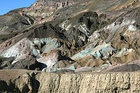 Artist's Drive rises up to the top of an alluvial fan
fed by a deep canyon cut into the Black Mountains. Artist's Palette is on the face of the Black Mountains and is noted for having various colors of rock. These colors are caused by the oxidation of different metal
s (red, pink and yellow is from iron salts, green is from decomposing tuff
-derived mica
, and manganese
produces the purple).
Called the Artist Drive Formation, the rock unit provides evidence for one of the Death Valley area's most violently explosive volcanic
periods. The Miocene
-aged formation is made up of cemented gravel, playa
deposits, and much volcanic debris, perhaps 5,000 feet (1500 m) thick. Chemical weathering and hydrothermal alteration are also responsible for the variety of colors displayed in the Artist Drive Formation and nearby exposures of the Furnace Creek Formation.
in North America
at 86 meters (282 ft) below sea level. (It is often mistakenly described as the lowest elevation in the Western Hemisphere, but that is actually Laguna del Carbón
in Argentina at −105 meters (−344 feet)). The massive expanse of white is made up of almost pure table salt.
This pan was first created by the drying-up of 30-foot (10 m) deep Recent Lake 2000 to 3000 years ago. Unlike at the Devils Golf Course, significant rainstorms flood
Badwater, covering the salt pan with a thin sheet of standing water. Each newly-formed lake doesn't last long though, because the 1.9 inch (48 mm) average rainfall is overwhelmed by a 150-inch (3800 mm) annual evaporation
rate. This, the nation's greatest evaporation potential, means that even a 12-foot (3.7 m) deep, 30 mile (50 km) long lake would dry up in a single year. While flooded, some of the salt is dissolved, then is redeposited as clean, sparkling crystals when the water evaporates.
, and were used to reduce Pinyon and Juniper
tree wood to charcoal
in a process of slow burning in low oxygen
. This fuel was then transported to mines
in Death Valley to feed smelting
and ore
extraction operations.
The kilns were abandoned three years after they were built, in 1870. They were restored by Navajo
Indian stonemasons from Arizona
in 1971.
The kilns were located here as the trees Single-leaf Pinyon Pine (Pinus monophylla)
and Utah juniper ( Juniperus osteosperma)
dominate the landscape in the upper Panamint Mountains. Shrubs of Mormon Tea (Ephedra sp.)
, such as Death Valley ephedra (Ephedra funerea)
, are spaced between them, with other xeric sub-shrubs and native
bunchgrasses.
Other historic charcoal kilns in the United States include the Cottonwood Charcoal Kilns at Owens Lake, the Piedmont Charcoal Kilns
in Wyoming, and the Walker Charcoal Kiln
in Arizona.
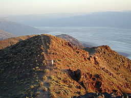
From Dante's View one can see the central part of Death Valley from a vantage point 5,500 feet (1,700 m) above sea level. From here Badwater Basin can be seen, which
contains the lowest dry point in North America. Telescope Peak
can also be seen from here which is 11,331 feet (3455 m) above sea level. This is the greatest topographic relief in the conterminous U.S.
The mountain that Dante's View is on is part of the Black Mountains
which along with the parallel Panamint Range
across the valley form what geologists call a horst and the valley that is called a graben
. These structures are created when the surface of the earth is under extensional, or a pulling force. The crust responds to this force by sending a large and long roughly v-shaped block of crust down which forms the bedrock of the valley floor (see Basin and Range
).
, and village that sits on top of a remarkably symmetrical alluvial fan
. The main visitor center of the park is located here as well as the Furnace Creek Inn and resort complex
. Controversy surrounds the use of Furnace Creek water to support the resort (complete with a swimming pool
) and nearby facilities, including a golf course
. The scarce springs and surrounding lush oases support thriving plant
communities and attract a wide variety of animals. As the resort grew, the marsh
es and wetland
s around it shrank.
The highest temperature in North America was recorded at Furnace Creek Ranch (134 °F or 57 °C).
The Furnace Creek Fault runs through this part of Death Valley.
series. The largest dune is called Star Dune and is relatively stable and stationary because it is at a point where the various winds that shape the dunes converge. The depth of the sand at its crest is 130–140 feet (40–43 m) but this is small compared to other dunes in the area that have sand depths of up to 600–700 feet (180–210 m) deep.
The primary source of the dune sands is probably the Cottonwood Mountains which lie to the north and northwest. The tiny grains of quartz
and feldspar
that form the sinuous sculptures that make up this dune field began as much larger pieces of solid rock
.
In between many of the dunes are stands of creosote bush
and some mesquite
on the sand and on dried mud, which used to cover this part of the valley before the dunes intruded (mesquite was the dominant plant here before the sand dunes but creosote does much better in the sand dune conditions).
s and cholla cactus. On the alluvial fan above the springs there are 2-3 thousand year old petroglyph
s from the extinct Mesquite Spring culture.
The petroglyphs here are made possible because many of the rocks in these arid conditions have desert varnish
on them. This particular form of desert varnish takes
10,000 years to make 1/100th of an inch of varnish and is deposited by a certain type of bacteria that collects the iron
, manganese
and clay
needed to make the varnish.
Also, since varnish is created at a predictable rate, it is possible to date petroglyphs based on the amount of re-varnishing that has taken place since the marks were made. Varnish does not normally form on carbonate rocks because their surfaces weather too easily.
In a wash near some of the petroglyphs there is a fault scarp
that exposes some fanglomerate which is a type of sedimentary rock which looks like concrete
with large rocks intermixed. In fact it is lithified alluvial sediment.
sediment with angular blocks of dolomite
in a pebbly matrix. The entrance to Mosaic Canyon appears deceptively ordinary, but just a 1/4 mile (400m) walk up the canyon narrows dramatically to a deep slot cut into the face of Tucki Mountain. Smooth, polished marble
walls enclose the trail as it follows the canyon's sinuous curves. The canyon follows faults that formed when the rocky crust of the Death Valley region began stretching just a few million years ago. Running water scoured away at the fault-weakened rock, gradually carving Mosaic canyon.
Periodic flash flood
s carry rocky debris (sediment) eroded from Mosaic Canyon and the surrounding hillsides toward the valley below. At the canyon mouth water spreads out and deposits its sediment load, gradually building up a large wedge-shaped alluvial fan
that extends down toward Stovepipe Wells. This canyon was formed through a process of cut and fill
which included periodic erosive floods followed by long periods of deposition and uplift. But due to the uplift when the next flood hit the area it would deeply cut the streambed which forms stair step-shaped banks.
Mosaic Canyon's polished marble walls are carved from the Noonday Dolomite and other Precambrian carbonate rock
s. These rock formation began as limestone
deposited during Late Precambrian
(about 850-700 million years ago) when the area was covered by a warm sea. Later addition of magnesium
changed the limestone, a rock made of calcium carbonate, to dolomite, a calcium-magnesium carbonate. The dolomite was later deeply buried by younger sediment. Far below the surface, high pressure and temperature altered the dolomite into the metamorphic rock
, marble. The Noonday Dolomite has since been tilted from uplift.
Mosaic Canyon was named for a rock formation known as the Mosaic Breccia. Breccia
is an Italian word meaning gravel. This formation is composed of angular fragments of many different kinds of parent rock, and it can be seen on the floor of the canyon just south of the parking area.
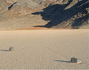
Racetrack Playa is a seasonally dry lake
(playa) located in the northern part of the Panamint Mountains that is famous for rocks that mysteriously move across its surface
. During periods of heavy rain, water washes down from nearby mountain slopes onto the playa, forming a shallow, short-lived lake. Most of the so-called 'sailing stones' are from a nearby high hillside of dark dolomite
on the south end of the playa. Similar rock travel patterns have been recorded in several other playas in the region but the number and length of travel grooves on The Racetrack are notable. Racetrack stones only move once every two or three years and most tracks last for just three or four years.
periodically flows at the surface. Over time the small amount of solutes in the water accumulate to form this linear salt pan. Another part of salt creek runs with brackish water year-round. It is here that the last survivor of Lake Manly resides; the Death Valley pupfish
.
habitat in the park behind the Saline Valley marsh in the western portion of the park and Cottonball Marsh in central Death Valley. This rare desert wetland
supports a rich community of plants and animals. Some of the species present, such as the Saratoga Springs pupfish
, are found nowhere else in the world.
was once an island in a lake that filled Death Valley several times during the Pleistocene
ice age
s. Scientists call all manifestations of this large body of water Lake Manly
. There are different horizontal linear features on northeast flank of the butte that are ancient shorelines from this lake.
It takes some time for waves to gnaw away terraces like the ones seen on Shoreline Butte, so these benches provide records of times when the lake level stabilized long enough for waves to leave their mark on the rock
. The highest strandline is one of the principal clues that geologists use to estimate the depth of the lake that once filled Death Valley. Shorelines of ancient Lake Manly are preserved in several parts of Death Valley, but nowhere is the record as clear as at Shoreline Butte. Several lakes have occupied Death Valley since the close of the Pleistocene epoch 10,000 years ago, but these younger lakes were quite shallow compared to Lake Manly (See Badwater and Devils Golf Course above).
near the eastern boundary of Death Valley National Park
. It features megabreccia
and other rock formations, petroglyph
s, and wildlife of various kinds, including bighorn sheep
. Along the road to the canyon stands Leadfield
, a ghost town
dating to the 1920s.
ic lava flow. The rocks on its exposed and barren ridge are famous for being shaped by wind erosion and are called ventifact
s. Sharp edges of ventifacts called Kanters are formed when two or more facets (planar surfaces) intersect. Open grooves in the ventifacts are called flutes. Most of the holes in the basalt are vesicles that were formed when gas escaped from the cooling lava. Some of these have been expanded or even merged by sandblasting.
Non-stop winds on this ridge are concentrated and compressed at the top of the hill and are very fast as a result. These strong winds pick-up dust and sand (mostly from the two closest alluvial fans), which literally sand-blast exposed surfaces. Winds strong enough for sandblasting come from the north and the south.
Death Valley
Death Valley is a desert valley located in Eastern California. Situated within the Mojave Desert, it features the lowest, driest, and hottest locations in North America. Badwater, a basin located in Death Valley, is the specific location of the lowest elevation in North America at 282 feet below...
area are mostly located within Death Valley National Park
Death Valley National Park
Death Valley National Park is a national park in the U.S. states of California and Nevada located east of the Sierra Nevada in the arid Great Basin of the United States. The park protects the northwest corner of the Mojave Desert and contains a diverse desert environment of salt-flats, sand dunes,...
in eastern California
California
California is a state located on the West Coast of the United States. It is by far the most populous U.S. state, and the third-largest by land area...
.
Artist's Drive and Palette
Alluvial fan
An alluvial fan is a fan-shaped deposit formed where a fast flowing stream flattens, slows, and spreads typically at the exit of a canyon onto a flatter plain. A convergence of neighboring alluvial fans into a single apron of deposits against a slope is called a bajada, or compound alluvial...
fed by a deep canyon cut into the Black Mountains. Artist's Palette is on the face of the Black Mountains and is noted for having various colors of rock. These colors are caused by the oxidation of different metal
Metal
A metal , is an element, compound, or alloy that is a good conductor of both electricity and heat. Metals are usually malleable and shiny, that is they reflect most of incident light...
s (red, pink and yellow is from iron salts, green is from decomposing tuff
Tuff
Tuff is a type of rock consisting of consolidated volcanic ash ejected from vents during a volcanic eruption. Tuff is sometimes called tufa, particularly when used as construction material, although tufa also refers to a quite different rock. Rock that contains greater than 50% tuff is considered...
-derived mica
Mica
The mica group of sheet silicate minerals includes several closely related materials having highly perfect basal cleavage. All are monoclinic, with a tendency towards pseudohexagonal crystals, and are similar in chemical composition...
, and manganese
Manganese
Manganese is a chemical element, designated by the symbol Mn. It has the atomic number 25. It is found as a free element in nature , and in many minerals...
produces the purple).
Called the Artist Drive Formation, the rock unit provides evidence for one of the Death Valley area's most violently explosive volcanic
Volcano
2. Bedrock3. Conduit 4. Base5. Sill6. Dike7. Layers of ash emitted by the volcano8. Flank| 9. Layers of lava emitted by the volcano10. Throat11. Parasitic cone12. Lava flow13. Vent14. Crater15...
periods. The Miocene
Miocene
The Miocene is a geological epoch of the Neogene Period and extends from about . The Miocene was named by Sir Charles Lyell. Its name comes from the Greek words and and means "less recent" because it has 18% fewer modern sea invertebrates than the Pliocene. The Miocene follows the Oligocene...
-aged formation is made up of cemented gravel, playa
Sink (geography)
A geographic sink is a depression within an endorheic basin where water collects with no visible outlet. Instead of discharging, the collected water is lost due to evaporation and/or penetration...
deposits, and much volcanic debris, perhaps 5,000 feet (1500 m) thick. Chemical weathering and hydrothermal alteration are also responsible for the variety of colors displayed in the Artist Drive Formation and nearby exposures of the Furnace Creek Formation.
Badwater Basin
Badwater is a salt flat that is beneath the face of the Black Mountains that contains the lowest elevationElevation
The elevation of a geographic location is its height above a fixed reference point, most commonly a reference geoid, a mathematical model of the Earth's sea level as an equipotential gravitational surface ....
in North America
North America
North America is a continent wholly within the Northern Hemisphere and almost wholly within the Western Hemisphere. It is also considered a northern subcontinent of the Americas...
at 86 meters (282 ft) below sea level. (It is often mistakenly described as the lowest elevation in the Western Hemisphere, but that is actually Laguna del Carbón
Laguna del Carbón
Laguna del Carbón is an endorheic salt lake in the Gran Bajo de San Julián of Santa Cruz Province, Argentina, 54 km from Puerto San Julián...
in Argentina at −105 meters (−344 feet)). The massive expanse of white is made up of almost pure table salt.
This pan was first created by the drying-up of 30-foot (10 m) deep Recent Lake 2000 to 3000 years ago. Unlike at the Devils Golf Course, significant rainstorms flood
Flood
A flood is an overflow of an expanse of water that submerges land. The EU Floods directive defines a flood as a temporary covering by water of land not normally covered by water...
Badwater, covering the salt pan with a thin sheet of standing water. Each newly-formed lake doesn't last long though, because the 1.9 inch (48 mm) average rainfall is overwhelmed by a 150-inch (3800 mm) annual evaporation
Evaporation
Evaporation is a type of vaporization of a liquid that occurs only on the surface of a liquid. The other type of vaporization is boiling, which, instead, occurs on the entire mass of the liquid....
rate. This, the nation's greatest evaporation potential, means that even a 12-foot (3.7 m) deep, 30 mile (50 km) long lake would dry up in a single year. While flooded, some of the salt is dissolved, then is redeposited as clean, sparkling crystals when the water evaporates.
Charcoal Kilns
The Charcoal Kilns were built in 1867 above Death Valley in the Panamint RangePanamint Range
The Panamint Range is a short rugged fault-block mountain range on the northern edge of the Mojave Desert, in Death Valley National Park, Inyo County, California, United States.-Geography:...
, and were used to reduce Pinyon and Juniper
Juniper
Junipers are coniferous plants in the genus Juniperus of the cypress family Cupressaceae. Depending on taxonomic viewpoint, there are between 50-67 species of juniper, widely distributed throughout the northern hemisphere, from the Arctic, south to tropical Africa in the Old World, and to the...
tree wood to charcoal
Charcoal
Charcoal is the dark grey residue consisting of carbon, and any remaining ash, obtained by removing water and other volatile constituents from animal and vegetation substances. Charcoal is usually produced by slow pyrolysis, the heating of wood or other substances in the absence of oxygen...
in a process of slow burning in low oxygen
Oxygen
Oxygen is the element with atomic number 8 and represented by the symbol O. Its name derives from the Greek roots ὀξύς and -γενής , because at the time of naming, it was mistakenly thought that all acids required oxygen in their composition...
. This fuel was then transported to mines
Mining
Mining is the extraction of valuable minerals or other geological materials from the earth, from an ore body, vein or seam. The term also includes the removal of soil. Materials recovered by mining include base metals, precious metals, iron, uranium, coal, diamonds, limestone, oil shale, rock...
in Death Valley to feed smelting
Smelting
Smelting is a form of extractive metallurgy; its main use is to produce a metal from its ore. This includes iron extraction from iron ore, and copper extraction and other base metals from their ores...
and ore
Ore
An ore is a type of rock that contains minerals with important elements including metals. The ores are extracted through mining; these are then refined to extract the valuable element....
extraction operations.
The kilns were abandoned three years after they were built, in 1870. They were restored by Navajo
Navajo Nation
The Navajo Nation is a semi-autonomous Native American-governed territory covering , occupying all of northeastern Arizona, the southeastern portion of Utah, and northwestern New Mexico...
Indian stonemasons from Arizona
Arizona
Arizona ; is a state located in the southwestern region of the United States. It is also part of the western United States and the mountain west. The capital and largest city is Phoenix...
in 1971.
The kilns were located here as the trees Single-leaf Pinyon Pine (Pinus monophylla)
Single-leaf Pinyon
The Single-leaf Pinyon, ', is a pine in the pinyon pine group, native to the United States and northwest Mexico. The range is in southernmost Idaho, western Utah, Arizona, southwest New Mexico, Nevada, eastern and southern California and northern Baja California.It occurs at moderate altitudes from...
and Utah juniper ( Juniperus osteosperma)
Juniperus osteosperma
Juniperus osteosperma is a shrub or small tree reaching 3-6 m tall. It is native to the southwestern United States, in Utah, Nevada, Arizona, western New Mexico, western Colorado, Wyoming, southern Montana, southern Idaho and eastern California...
dominate the landscape in the upper Panamint Mountains. Shrubs of Mormon Tea (Ephedra sp.)
Ephedra
Ephedra refers to the plant Ephedra sinica. E. sinica, known in Chinese as ma huang , has been used in traditional Chinese medicine for 5,000 years for the treatment of asthma and hay fever, as well as for the common cold...
, such as Death Valley ephedra (Ephedra funerea)
Ephedra funerea
Ephedra funerea is a species of Ephedra known by the common name Death Valley jointfir, or Death Valley ephedra. It is native to the Mojave Desert of California and Nevada. This shrub is made up of erect twigs which are gray-green when new and age to gray and cracked. There are tiny leaves at nodes...
, are spaced between them, with other xeric sub-shrubs and native
Native plant
Native plant is a term to describe plants endemic or naturalized to a given area in geologic time.This includes plants that have developed, occur naturally, or existed for many years in an area...
bunchgrasses.
Other historic charcoal kilns in the United States include the Cottonwood Charcoal Kilns at Owens Lake, the Piedmont Charcoal Kilns
Piedmont Charcoal Kilns
The Piedmont Charcoal Kilns in Piedmont, Wyoming are a remnant of a once-extensive charcoal-making industry in southwestern Wyoming. The kilns were built by Moses Byrne around 1869 near the Piedmont Station along the Union Pacific Railroad. The three surviving beehive-shaped kilns were built of...
in Wyoming, and the Walker Charcoal Kiln
Walker Charcoal Kiln
The Walker Charcoal Kiln is a structure in the Prescott National Forest near the ghost town of Walker, Arizona. It is listed on the National Register of Historic Places. A sign posted near the kiln reads, "This kiln was constructed around 1880 by Jake and Joe Carmichael to convert oak wood into...
in Arizona.
Dante's View
From Dante's View one can see the central part of Death Valley from a vantage point 5,500 feet (1,700 m) above sea level. From here Badwater Basin can be seen, which
contains the lowest dry point in North America. Telescope Peak
Telescope Peak
Telescope Peak is the highest point within Death Valley National Park, in the US state of California. It is also the highest point of the Panamint Range, and lies in Inyo County. From atop this desert mountain one can see for over one hundred miles in many directions, including west to Mount...
can also be seen from here which is 11,331 feet (3455 m) above sea level. This is the greatest topographic relief in the conterminous U.S.
The mountain that Dante's View is on is part of the Black Mountains
Black Mountains (California)
The Black Mountains are located in the southeastern part of Inyo County, California, in southeast Death Valley National Park.-Geography:The Black Mountains are essentially a continuation of the Amargosa Range, and lie in a generally north-south direction at the south-southwest end...
which along with the parallel Panamint Range
Panamint Range
The Panamint Range is a short rugged fault-block mountain range on the northern edge of the Mojave Desert, in Death Valley National Park, Inyo County, California, United States.-Geography:...
across the valley form what geologists call a horst and the valley that is called a graben
Graben
In geology, a graben is a depressed block of land bordered by parallel faults. Graben is German for ditch. Graben is used for both the singular and plural....
. These structures are created when the surface of the earth is under extensional, or a pulling force. The crust responds to this force by sending a large and long roughly v-shaped block of crust down which forms the bedrock of the valley floor (see Basin and Range
Basin and Range
The Basin and Range Province is a vast physiographic region defined by a unique topographic expression. Basin and Range topography is characterized by abrupt changes in elevation, alternating between narrow faulted mountain chains and flat arid valleys or basins...
).
Furnace Creek
Furnace Creek is a spring, oasisOasis
In geography, an oasis or cienega is an isolated area of vegetation in a desert, typically surrounding a spring or similar water source...
, and village that sits on top of a remarkably symmetrical alluvial fan
Alluvial fan
An alluvial fan is a fan-shaped deposit formed where a fast flowing stream flattens, slows, and spreads typically at the exit of a canyon onto a flatter plain. A convergence of neighboring alluvial fans into a single apron of deposits against a slope is called a bajada, or compound alluvial...
. The main visitor center of the park is located here as well as the Furnace Creek Inn and resort complex
Furnace Creek Inn and Ranch Resort
The Furnace Creek Inn and Ranch Resort is a privately owned luxury resort in California's Death Valley National Park operated by Xanterra.-Furnace Creek Inn:...
. Controversy surrounds the use of Furnace Creek water to support the resort (complete with a swimming pool
Swimming pool
A swimming pool, swimming bath, wading pool, or simply a pool, is a container filled with water intended for swimming or water-based recreation. There are many standard sizes; the largest is the Olympic-size swimming pool...
) and nearby facilities, including a golf course
Golf course
A golf course comprises a series of holes, each consisting of a teeing ground, fairway, rough and other hazards, and a green with a flagstick and cup, all designed for the game of golf. A standard round of golf consists of playing 18 holes, thus most golf courses have this number of holes...
. The scarce springs and surrounding lush oases support thriving plant
Plant
Plants are living organisms belonging to the kingdom Plantae. Precise definitions of the kingdom vary, but as the term is used here, plants include familiar organisms such as trees, flowers, herbs, bushes, grasses, vines, ferns, mosses, and green algae. The group is also called green plants or...
communities and attract a wide variety of animals. As the resort grew, the marsh
Marsh
In geography, a marsh, or morass, is a type of wetland that is subject to frequent or continuous flood. Typically the water is shallow and features grasses, rushes, reeds, typhas, sedges, other herbaceous plants, and moss....
es and wetland
Wetland
A wetland is an area of land whose soil is saturated with water either permanently or seasonally. Wetlands are categorised by their characteristic vegetation, which is adapted to these unique soil conditions....
s around it shrank.
The highest temperature in North America was recorded at Furnace Creek Ranch (134 °F or 57 °C).
The Furnace Creek Fault runs through this part of Death Valley.
Mesquite Flat Sand Dunes
The Mesquite Flat Sand Dunes are at the northern end of the valley floor and are nearly surrounded by mountains on all sides. Due to their easy access from the road and the overall proximity of Death Valley to Hollywood, these dunes have been used to film sand dune scenes for several movies including films in the Star WarsStar Wars
Star Wars is an American epic space opera film series created by George Lucas. The first film in the series was originally released on May 25, 1977, under the title Star Wars, by 20th Century Fox, and became a worldwide pop culture phenomenon, followed by two sequels, released at three-year...
series. The largest dune is called Star Dune and is relatively stable and stationary because it is at a point where the various winds that shape the dunes converge. The depth of the sand at its crest is 130–140 feet (40–43 m) but this is small compared to other dunes in the area that have sand depths of up to 600–700 feet (180–210 m) deep.
The primary source of the dune sands is probably the Cottonwood Mountains which lie to the north and northwest. The tiny grains of quartz
Quartz
Quartz is the second-most-abundant mineral in the Earth's continental crust, after feldspar. It is made up of a continuous framework of SiO4 silicon–oxygen tetrahedra, with each oxygen being shared between two tetrahedra, giving an overall formula SiO2. There are many different varieties of quartz,...
and feldspar
Feldspar
Feldspars are a group of rock-forming tectosilicate minerals which make up as much as 60% of the Earth's crust....
that form the sinuous sculptures that make up this dune field began as much larger pieces of solid rock
Rock (geology)
In geology, rock or stone is a naturally occurring solid aggregate of minerals and/or mineraloids.The Earth's outer solid layer, the lithosphere, is made of rock. In general rocks are of three types, namely, igneous, sedimentary, and metamorphic...
.
In between many of the dunes are stands of creosote bush
Creosote bush
Larrea tridentata is known as Creosote bush as a plant, chaparral as a medicinal herb, and as "gobernadora" in Mexico, Spanish for "governess," due to its ability for inhibiting the growth of nearby plants to have more water. In Sonora, it is more commonly called "hediondilla." It is a flowering...
and some mesquite
Mesquite
Mesquite is a leguminous plant of the Prosopis genus found in northern Mexico through the Sonoran Desert and Chihuahuan Deserts, and up into the Southwestern United States as far north as southern Kansas, west to the Colorado Desert in California,and east to the eastern fifth of Texas, where...
on the sand and on dried mud, which used to cover this part of the valley before the dunes intruded (mesquite was the dominant plant here before the sand dunes but creosote does much better in the sand dune conditions).
Mesquite Spring
Mesquite Spring is located in the northernmost part of Death Valley. This part of the valley has numerous cotton top cactus, blister beetleBlister beetle
Blister beetles are beetles of the family Meloidae, so called for their defensive secretion of a blistering agent, cantharidin. There are approximately 7,500 known species worldwide. Many are conspicuous and some aposematically colored, announcing their toxicity to would-be...
s and cholla cactus. On the alluvial fan above the springs there are 2-3 thousand year old petroglyph
Petroglyph
Petroglyphs are pictogram and logogram images created by removing part of a rock surface by incising, picking, carving, and abrading. Outside North America, scholars often use terms such as "carving", "engraving", or other descriptions of the technique to refer to such images...
s from the extinct Mesquite Spring culture.
The petroglyphs here are made possible because many of the rocks in these arid conditions have desert varnish
Desert varnish
Desert varnish, or rock varnish is a orange-yellow to black coating found on exposed rock surfaces in arid environments. Desert varnish is usually around one micron thick and present nanometre-scale layering...
on them. This particular form of desert varnish takes
10,000 years to make 1/100th of an inch of varnish and is deposited by a certain type of bacteria that collects the iron
Iron
Iron is a chemical element with the symbol Fe and atomic number 26. It is a metal in the first transition series. It is the most common element forming the planet Earth as a whole, forming much of Earth's outer and inner core. It is the fourth most common element in the Earth's crust...
, manganese
Manganese
Manganese is a chemical element, designated by the symbol Mn. It has the atomic number 25. It is found as a free element in nature , and in many minerals...
and clay
Clay
Clay is a general term including many combinations of one or more clay minerals with traces of metal oxides and organic matter. Geologic clay deposits are mostly composed of phyllosilicate minerals containing variable amounts of water trapped in the mineral structure.- Formation :Clay minerals...
needed to make the varnish.
Also, since varnish is created at a predictable rate, it is possible to date petroglyphs based on the amount of re-varnishing that has taken place since the marks were made. Varnish does not normally form on carbonate rocks because their surfaces weather too easily.
In a wash near some of the petroglyphs there is a fault scarp
Fault scarp
A fault scarp is the topographic expression of faulting attributed to the displacement of the land surface by movement along faults. They are exhibited either by differential movement and subsequent erosion along an old inactive geologic fault , or by a movement on a recent active fault...
that exposes some fanglomerate which is a type of sedimentary rock which looks like concrete
Concrete
Concrete is a composite construction material, composed of cement and other cementitious materials such as fly ash and slag cement, aggregate , water and chemical admixtures.The word concrete comes from the Latin word...
with large rocks intermixed. In fact it is lithified alluvial sediment.
Mosaic Canyon
Mosaic Canyon is a canyon in the north western mountain face of the valley which is named after a stream-derived brecciaBreccia
Breccia is a rock composed of broken fragments of minerals or rock cemented together by a fine-grained matrix, that can be either similar to or different from the composition of the fragments....
sediment with angular blocks of dolomite
Dolomite
Dolomite is a carbonate mineral composed of calcium magnesium carbonate CaMg2. The term is also used to describe the sedimentary carbonate rock dolostone....
in a pebbly matrix. The entrance to Mosaic Canyon appears deceptively ordinary, but just a 1/4 mile (400m) walk up the canyon narrows dramatically to a deep slot cut into the face of Tucki Mountain. Smooth, polished marble
Marble
Marble is a metamorphic rock composed of recrystallized carbonate minerals, most commonly calcite or dolomite.Geologists use the term "marble" to refer to metamorphosed limestone; however stonemasons use the term more broadly to encompass unmetamorphosed limestone.Marble is commonly used for...
walls enclose the trail as it follows the canyon's sinuous curves. The canyon follows faults that formed when the rocky crust of the Death Valley region began stretching just a few million years ago. Running water scoured away at the fault-weakened rock, gradually carving Mosaic canyon.
Periodic flash flood
Flash flood
A flash flood is a rapid flooding of geomorphic low-lying areas—washes, rivers, dry lakes and basins. It may be caused by heavy rain associated with a storm, hurricane, or tropical storm or meltwater from ice or snow flowing over ice sheets or snowfields...
s carry rocky debris (sediment) eroded from Mosaic Canyon and the surrounding hillsides toward the valley below. At the canyon mouth water spreads out and deposits its sediment load, gradually building up a large wedge-shaped alluvial fan
Alluvial fan
An alluvial fan is a fan-shaped deposit formed where a fast flowing stream flattens, slows, and spreads typically at the exit of a canyon onto a flatter plain. A convergence of neighboring alluvial fans into a single apron of deposits against a slope is called a bajada, or compound alluvial...
that extends down toward Stovepipe Wells. This canyon was formed through a process of cut and fill
Cut and fill
In earthmoving, cut and fill is the process of constructing a railway, road or canal whereby the amount of material from cuts roughly matches the amount of fill needed to make nearby embankments, so minimizing the amount of construction labor...
which included periodic erosive floods followed by long periods of deposition and uplift. But due to the uplift when the next flood hit the area it would deeply cut the streambed which forms stair step-shaped banks.
Mosaic Canyon's polished marble walls are carved from the Noonday Dolomite and other Precambrian carbonate rock
Carbonate rock
Carbonate rocks are a class of sedimentary rocks composed primarily of carbonate minerals. The two major types are limestone, which is composed of calcite or aragonite and dolostone, which is composed of the mineral dolomite .Calcite can be either dissolved by groundwater or precipitated by...
s. These rock formation began as limestone
Limestone
Limestone is a sedimentary rock composed largely of the minerals calcite and aragonite, which are different crystal forms of calcium carbonate . Many limestones are composed from skeletal fragments of marine organisms such as coral or foraminifera....
deposited during Late Precambrian
Precambrian
The Precambrian is the name which describes the large span of time in Earth's history before the current Phanerozoic Eon, and is a Supereon divided into several eons of the geologic time scale...
(about 850-700 million years ago) when the area was covered by a warm sea. Later addition of magnesium
Magnesium
Magnesium is a chemical element with the symbol Mg, atomic number 12, and common oxidation number +2. It is an alkaline earth metal and the eighth most abundant element in the Earth's crust and ninth in the known universe as a whole...
changed the limestone, a rock made of calcium carbonate, to dolomite, a calcium-magnesium carbonate. The dolomite was later deeply buried by younger sediment. Far below the surface, high pressure and temperature altered the dolomite into the metamorphic rock
Metamorphic rock
Metamorphic rock is the transformation of an existing rock type, the protolith, in a process called metamorphism, which means "change in form". The protolith is subjected to heat and pressure causing profound physical and/or chemical change...
, marble. The Noonday Dolomite has since been tilted from uplift.
Mosaic Canyon was named for a rock formation known as the Mosaic Breccia. Breccia
Breccia
Breccia is a rock composed of broken fragments of minerals or rock cemented together by a fine-grained matrix, that can be either similar to or different from the composition of the fragments....
is an Italian word meaning gravel. This formation is composed of angular fragments of many different kinds of parent rock, and it can be seen on the floor of the canyon just south of the parking area.
Natural Bridge Canyon
Natural Bridge Canyon is found on the east side of the park and is one of the few canyons with an official trailhead. Located four miles (6 km) south of the Artist's Drive scenic loop, the canyon contains a natural stone bridge, accessible after a fifteen-minute walk from the parking area.Racetrack Playa
Racetrack Playa is a seasonally dry lake
Dry lake
Dry lakes are ephemeral lakebeds, or a remnant of an endorheic lake. Such flats consist of fine-grained sediments infused with alkali salts. Dry lakes are also referred to as alkali flats, sabkhas, playas or mud flats...
(playa) located in the northern part of the Panamint Mountains that is famous for rocks that mysteriously move across its surface
Sailing stones
Sailing stones, sliding rocks, and moving rocks all refer to a geological phenomenon where rocks move in long tracks along a smooth valley floor without human or animal intervention. They have been recorded and studied in a number of places around Racetrack Playa, Death Valley, where the number and...
. During periods of heavy rain, water washes down from nearby mountain slopes onto the playa, forming a shallow, short-lived lake. Most of the so-called 'sailing stones' are from a nearby high hillside of dark dolomite
Dolomite
Dolomite is a carbonate mineral composed of calcium magnesium carbonate CaMg2. The term is also used to describe the sedimentary carbonate rock dolostone....
on the south end of the playa. Similar rock travel patterns have been recorded in several other playas in the region but the number and length of travel grooves on The Racetrack are notable. Racetrack stones only move once every two or three years and most tracks last for just three or four years.
Red Cathedral
Red Cathedral is a geological formation located between highways 178 and 190. Formed of steep cliffs, it is composed of red colored oxidized rocks and is visible from Zabriskie point and the Golden Canyon trail.Salt Creek
Much of Salt Creek is usually dry at the surface and covered by a bright layer of salt which was created by many flooding and subsequent evaporation of water thatperiodically flows at the surface. Over time the small amount of solutes in the water accumulate to form this linear salt pan. Another part of salt creek runs with brackish water year-round. It is here that the last survivor of Lake Manly resides; the Death Valley pupfish
Death Valley pupfish
The Death Valley pupfish, Cyprinodon salinus salinus, is found in Death Valley National Park.-Description:The Death Valley pupfish is a species of fish that is the last known survivor of what is thought to have been a large ecosystem of fish species that lived in Lake Manly, which dried up at the...
.
Saratoga Springs
The waters of Saratoga Springs rise near the southern boundary of the park. Several springs feed three large open water ponds measuring 6.6 acres (2.7 ha) in size, the third largest marshMarsh
In geography, a marsh, or morass, is a type of wetland that is subject to frequent or continuous flood. Typically the water is shallow and features grasses, rushes, reeds, typhas, sedges, other herbaceous plants, and moss....
habitat in the park behind the Saline Valley marsh in the western portion of the park and Cottonball Marsh in central Death Valley. This rare desert wetland
Wetland
A wetland is an area of land whose soil is saturated with water either permanently or seasonally. Wetlands are categorised by their characteristic vegetation, which is adapted to these unique soil conditions....
supports a rich community of plants and animals. Some of the species present, such as the Saratoga Springs pupfish
Saratoga Springs pupfish
The Saratoga Springs pupfish is a subspecies of the Amargosa pupfish of the family Cyprinodontidae. The native population is endemic to Saratoga Springs, a small wetland in Death Valley National Park in the United States.-Taxonomy:The pupfish is a member of the genus Cyprinodon...
, are found nowhere else in the world.
Shoreline Butte
This desert butteButte
A butte is a conspicuous isolated hill with steep, often vertical sides and a small, relatively flat top; it is smaller than mesas, plateaus, and table landform tables. In some regions, such as the north central and northwestern United States, the word is used for any hill...
was once an island in a lake that filled Death Valley several times during the Pleistocene
Pleistocene
The Pleistocene is the epoch from 2,588,000 to 11,700 years BP that spans the world's recent period of repeated glaciations. The name pleistocene is derived from the Greek and ....
ice age
Ice age
An ice age or, more precisely, glacial age, is a generic geological period of long-term reduction in the temperature of the Earth's surface and atmosphere, resulting in the presence or expansion of continental ice sheets, polar ice sheets and alpine glaciers...
s. Scientists call all manifestations of this large body of water Lake Manly
Lake Manly
Lake Manly is a pluvial, former freshwater, endorheic, rift lake that filled the Death Valley basin of Inyo County, California through the Holocene before the area's climate changed to desert. Following its isolation from the Colorado River system, Lake Manly receded by evaporation with Badwater...
. There are different horizontal linear features on northeast flank of the butte that are ancient shorelines from this lake.
It takes some time for waves to gnaw away terraces like the ones seen on Shoreline Butte, so these benches provide records of times when the lake level stabilized long enough for waves to leave their mark on the rock
Rock (geology)
In geology, rock or stone is a naturally occurring solid aggregate of minerals and/or mineraloids.The Earth's outer solid layer, the lithosphere, is made of rock. In general rocks are of three types, namely, igneous, sedimentary, and metamorphic...
. The highest strandline is one of the principal clues that geologists use to estimate the depth of the lake that once filled Death Valley. Shorelines of ancient Lake Manly are preserved in several parts of Death Valley, but nowhere is the record as clear as at Shoreline Butte. Several lakes have occupied Death Valley since the close of the Pleistocene epoch 10,000 years ago, but these younger lakes were quite shallow compared to Lake Manly (See Badwater and Devils Golf Course above).
Titus Canyon
Titus Canyon is a narrow gorge in the Grapevine MountainsGrapevine Mountains
The Grapevine Mountains are located along the eastern border of California in the United States. The mountain range is about long and lies in a northwest-southeasterly direction along the Nevada-California state line. The range reaches an elevation of at Grapevine Peak, near Phinney Canyon on the...
near the eastern boundary of Death Valley National Park
Death Valley National Park
Death Valley National Park is a national park in the U.S. states of California and Nevada located east of the Sierra Nevada in the arid Great Basin of the United States. The park protects the northwest corner of the Mojave Desert and contains a diverse desert environment of salt-flats, sand dunes,...
. It features megabreccia
Breccia
Breccia is a rock composed of broken fragments of minerals or rock cemented together by a fine-grained matrix, that can be either similar to or different from the composition of the fragments....
and other rock formations, petroglyph
Petroglyph
Petroglyphs are pictogram and logogram images created by removing part of a rock surface by incising, picking, carving, and abrading. Outside North America, scholars often use terms such as "carving", "engraving", or other descriptions of the technique to refer to such images...
s, and wildlife of various kinds, including bighorn sheep
Bighorn Sheep
The bighorn sheep is a species of sheep in North America named for its large horns. These horns can weigh up to , while the sheep themselves weigh up to . Recent genetic testing indicates that there are three distinct subspecies of Ovis canadensis, one of which is endangered: Ovis canadensis sierrae...
. Along the road to the canyon stands Leadfield
Leadfield, California
Leadfield was an unincorporated community, and historic mining town in Inyo County, California. It is now a ghost town. It is located in Titus Canyon in the Grapevine Mountains, east of Death Valley in Death Valley National Park. Leadfield lies at an elevation of 4058 feet...
, a ghost town
Ghost town
A ghost town is an abandoned town or city. A town often becomes a ghost town because the economic activity that supported it has failed, or due to natural or human-caused disasters such as floods, government actions, uncontrolled lawlessness, war, or nuclear disasters...
dating to the 1920s.
Ventifact Ridge
Ventifact Ridge is a part of a basaltBasalt
Basalt is a common extrusive volcanic rock. It is usually grey to black and fine-grained due to rapid cooling of lava at the surface of a planet. It may be porphyritic containing larger crystals in a fine matrix, or vesicular, or frothy scoria. Unweathered basalt is black or grey...
ic lava flow. The rocks on its exposed and barren ridge are famous for being shaped by wind erosion and are called ventifact
Ventifact
Ventifacts are rocks that have been abraded, pitted, etched, grooved, or polished by wind-driven sand or ice crystals. These geomorphic features are most typically found in arid environments where there is little vegetation to interfere with aeolian particle transport, where there are frequently...
s. Sharp edges of ventifacts called Kanters are formed when two or more facets (planar surfaces) intersect. Open grooves in the ventifacts are called flutes. Most of the holes in the basalt are vesicles that were formed when gas escaped from the cooling lava. Some of these have been expanded or even merged by sandblasting.
Non-stop winds on this ridge are concentrated and compressed at the top of the hill and are very fast as a result. These strong winds pick-up dust and sand (mostly from the two closest alluvial fans), which literally sand-blast exposed surfaces. Winds strong enough for sandblasting come from the north and the south.