

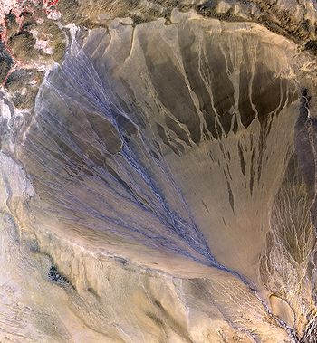
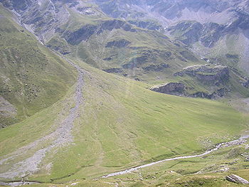
Alluvial fan
Encyclopedia
Fan (implement)
A hand-held fan is an implement used to induce an airflow for the purpose of cooling or refreshing oneself. Any broad, flat surface waved back-and-forth will create a small airflow and therefore can be considered a rudimentary fan...
-shaped deposit
Deposition (geology)
Deposition is the geological process by which material is added to a landform or land mass. Fluids such as wind and water, as well as sediment flowing via gravity, transport previously eroded sediment, which, at the loss of enough kinetic energy in the fluid, is deposited, building up layers of...
formed where a fast flowing stream
Stream
A stream is a body of water with a current, confined within a bed and stream banks. Depending on its locale or certain characteristics, a stream may be referred to as a branch, brook, beck, burn, creek, "crick", gill , kill, lick, rill, river, syke, bayou, rivulet, streamage, wash, run or...
flattens, slows, and spreads typically at the exit of a canyon
Canyon
A canyon or gorge is a deep ravine between cliffs often carved from the landscape by a river. Rivers have a natural tendency to reach a baseline elevation, which is the same elevation as the body of water it will eventually drain into. This forms a canyon. Most canyons were formed by a process of...
onto a flatter plain
Plain
In geography, a plain is land with relatively low relief, that is flat or gently rolling. Prairies and steppes are types of plains, and the archetype for a plain is often thought of as a grassland, but plains in their natural state may also be covered in shrublands, woodland and forest, or...
. A convergence of neighboring alluvial fans into a single apron of deposits against a slope is called a bajada, or compound alluvial fan.
Formation
As a stream's gradient decreases, it drops coarse-grained material. This reduces the capacity of the channel and forces it to change direction and gradually building up a slightly mounded or shallow conical fan shape. The deposits are usually poorly-sortedSorting (sediment)
Sorting indicates the distribution of grain size of sediments, either in unconsolidated deposits or in sedimentary rocks. Poorly sorted indicates that the sediment sizes are mixed ; whereas well sorted indicates that the sediment sizes are similar .The degree of sorting may also indicate the energy...
. This fan shape can also be explained with a thermodynamic justification: the system of sediment
Sediment
Sediment is naturally occurring material that is broken down by processes of weathering and erosion, and is subsequently transported by the action of fluids such as wind, water, or ice, and/or by the force of gravity acting on the particle itself....
introduced at the apex of the fan will tend to a state which minimizes the sum of the transport energy
Energy
In physics, energy is an indirectly observed quantity. It is often understood as the ability a physical system has to do work on other physical systems...
involved in moving the sediment and the gravitational potential of material in the cone. There will be iso-transport energy lines forming concentric arc
Arc (geometry)
In geometry, an arc is a closed segment of a differentiable curve in the two-dimensional plane; for example, a circular arc is a segment of the circumference of a circle...
s about the discharge point at the apex of the fan. Thus the material will tend to be deposited equally about these lines, forming the characteristic cone shape.
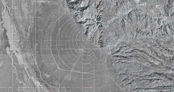
In arid climates
Alluvial fans are often found in desertDesert
A desert is a landscape or region that receives an extremely low amount of precipitation, less than enough to support growth of most plants. Most deserts have an average annual precipitation of less than...
areas subject to periodic flash flood
Flash flood
A flash flood is a rapid flooding of geomorphic low-lying areas—washes, rivers, dry lakes and basins. It may be caused by heavy rain associated with a storm, hurricane, or tropical storm or meltwater from ice or snow flowing over ice sheets or snowfields...
s from nearby thunderstorms in local hill
Hill
A hill is a landform that extends above the surrounding terrain. Hills often have a distinct summit, although in areas with scarp/dip topography a hill may refer to a particular section of flat terrain without a massive summit A hill is a landform that extends above the surrounding terrain. Hills...
s. They are common around the margins of the sedimentary basin
Sedimentary basin
The term sedimentary basin is used to refer to any geographical feature exhibiting subsidence and consequent infilling by sedimentation. As the sediments are buried, they are subjected to increasing pressure and begin the process of lithification...
s of the Basin and Range
Basin and Range
The Basin and Range Province is a vast physiographic region defined by a unique topographic expression. Basin and Range topography is characterized by abrupt changes in elevation, alternating between narrow faulted mountain chains and flat arid valleys or basins...
province of southwestern North America
North America
North America is a continent wholly within the Northern Hemisphere and almost wholly within the Western Hemisphere. It is also considered a northern subcontinent of the Americas...
. The typical watercourse
Watercourse
A watercourse is any flowing body of water. These include rivers, streams, anabranches, and so forth.-See also:* physical geography* Environmental flow* Waterway* Hydrology* Wadi-External links:...
in an arid
Arid
A region is said to be arid when it is characterized by a severe lack of available water, to the extent of hindering or even preventing the growth and development of plant and animal life...
climate
Climate
Climate encompasses the statistics of temperature, humidity, atmospheric pressure, wind, rainfall, atmospheric particle count and other meteorological elemental measurements in a given region over long periods...
has a large, funnel-shaped basin at the top, leading to a narrow defile
Defile (geography)
Defile is a geographic term for a narrow pass or gorge between mountains or hills. It has its origins as a military description of a pass through which troops can march only in a narrow column or with a narrow front...
, which opens out into an alluvial fan at the bottom. Multiple braided streams are usually present and active during water flows.
Phreatophytes are plant
Plant
Plants are living organisms belonging to the kingdom Plantae. Precise definitions of the kingdom vary, but as the term is used here, plants include familiar organisms such as trees, flowers, herbs, bushes, grasses, vines, ferns, mosses, and green algae. The group is also called green plants or...
s that are often concentrated at the base of alluvial fans. They have long tap root
Root
In vascular plants, the root is the organ of a plant that typically lies below the surface of the soil. This is not always the case, however, since a root can also be aerial or aerating . Furthermore, a stem normally occurring below ground is not exceptional either...
s 30 to 50 ft (9.1 to 15.2 ) to reach water that has seeped through the fan and hit an impermeable layer, sometimes collecting in springs
Spring (hydrosphere)
A spring—also known as a rising or resurgence—is a component of the hydrosphere. Specifically, it is any natural situation where water flows to the surface of the earth from underground...
and seeps
Seep (hydrology)
A Seep is a moist or wet place where water, usually groundwater, reaches the earth's surface from an underground aquifer.-Description:Seeps are usually not of sufficient volume to be flowing beyond their above-ground location. They are part of the limnology-geomorphology system...
. These stands of shrub
Shrub
A shrub or bush is distinguished from a tree by its multiple stems and shorter height, usually under 5–6 m tall. A large number of plants may become either shrubs or trees, depending on the growing conditions they experience...
s cling to the soil
Soil
Soil is a natural body consisting of layers of mineral constituents of variable thicknesses, which differ from the parent materials in their morphological, physical, chemical, and mineralogical characteristics...
at their bases and often form islands of habitat
Habitat (ecology)
A habitat is an ecological or environmental area that is inhabited by a particular species of animal, plant or other type of organism...
for many animal
Animal
Animals are a major group of multicellular, eukaryotic organisms of the kingdom Animalia or Metazoa. Their body plan eventually becomes fixed as they develop, although some undergo a process of metamorphosis later on in their life. Most animals are motile, meaning they can move spontaneously and...
s as the wind
Wind
Wind is the flow of gases on a large scale. On Earth, wind consists of the bulk movement of air. In outer space, solar wind is the movement of gases or charged particles from the sun through space, while planetary wind is the outgassing of light chemical elements from a planet's atmosphere into space...
blows the sand
Sand
Sand is a naturally occurring granular material composed of finely divided rock and mineral particles.The composition of sand is highly variable, depending on the local rock sources and conditions, but the most common constituent of sand in inland continental settings and non-tropical coastal...
around the bushes away.
In humid climates
Alluvial fans also develop in wetter climates. In NepalGeography of Nepal
Nepal measures about along its himalayan axis by across. With it slightly outranks Bangladesh or the state of Arkansas. Nepal is landlocked by India on three sides and China's Xizang Autonomous Region to the north. West Bengal's narrow Siliguri Corridor or Chicken's Neck separate Nepal and...
the Koshi River
Koshi River
The Kosi River or Koshi —also Saptakoshi for its seven Himalayan tributaries—is a trans-boundary river flowing through Nepal and India. Some of the rivers of the Koshi system, such as the Arun, the Sun Kosi and the Bhote Koshi, originate in the Tibet Autonomous Region of China...
has built a megafan covering some 150000 km² (57,915.3 sq mi) below its exit from Himalayan foothills
Mahabharat Lekh
The Mahabharat Range -- also called the Lesser Himalaya -- is a major east-west mountain range [a series of east-west mountain ranges] with elevations 1,500 to 2,700 metres along the crest, paralleling the much higher Great Himalaya range from the Indus River in Pakistan across northern India,...
onto the nearly level plains where the river traverses into India
Geography of India
The geography of India describes the physical features of India, a country in South Asia, that lies entirely on the Indian Plate in the northern portion of the Indo-Australian Plate. The country lies to the north of the equator between 8°4' and 37°6' north latitude and 68°7' and 97°25' east...
before joining the Ganges. Along the upper Koshi tributaries, tectonic forces elevate the Himalayas
Himalayas
The Himalaya Range or Himalaya Mountains Sanskrit: Devanagari: हिमालय, literally "abode of snow"), usually called the Himalayas or Himalaya for short, is a mountain range in Asia, separating the Indian subcontinent from the Tibetan Plateau...
several millimeters annually. Uplift is approximately in equilibrium with erosion, so the river annually carries some 100 million cubic meters (3.5 billion cu ft) of sediment as it exits the mountains. Deposition of this magnitude over millions of years is more than sufficient to account for the megafan.
In North America, streams flowing into California's Central Valley have deposited smaller but still extensive alluvial fans. That of the Kings River flowing out of the Sierra Nevada creates a low divide, turning the south end of the San Joaquin Valley
San Joaquin Valley
The San Joaquin Valley is the area of the Central Valley of California that lies south of the Sacramento – San Joaquin River Delta in Stockton...
into an Endorheic basin without a connection to the ocean.
Flood hazards
Alluvial fans are subject to flooding and can be even more dangerous than the upstream canyons that feed them. Their slightly convex perpendicular surfaces cause water to spread widely until there is no zone of refuge. If the gradient is steep, active transport of materials down the fan creates a moving substrate that is inhospitable to travel on foot or wheels. But as the gradient diminishes downslope, water comes down from above faster than it can flow away downstream, and may pond to hazardous depths.In the case of the Koshi River, the huge sediment load and megafan's slightly convex transverse surface conspire against engineering efforts to contain peak flows inside manmade embankments. In August 2008
2008 Bihar flood
The 2008 Bihar flood was one of the most disastrous floods in the history of Bihar, an impoverished and densely populated state in India. A breach in the Kosi embankment near the Indo-Nepal border occurred on 18 August 2008. The river changed course and inundated areas which hadn't experienced...
high monsoon flows breached the embankment, diverting most of the river into an unprotected ancient channel and across surrounding lands with high population density. Over a million people were rendered homeless, about a thousand lost their lives and thousands of hectares of crops were destroyed. The Koshi is known as the Sorrow of Bihar for contributing disproportionately to India's death tolls in flooding, which exceed those of all countries except Bangladesh
Geography of Bangladesh
Bangladesh is a low-lying, riverine country located in South Asia with a largely marshy jungle coastline of on the northern littoral of the Bay of Bengal. Formed by a delta plain at the confluence of the Ganges , Brahmaputra , and Meghna Rivers and their tributaries, Bangladesh's alluvial soil is...
.
See also
- AlluviumAlluviumAlluvium is loose, unconsolidated soil or sediments, eroded, deposited, and reshaped by water in some form in a non-marine setting. Alluvium is typically made up of a variety of materials, including fine particles of silt and clay and larger particles of sand and gravel...
- Alluvial plainAlluvial plainAn alluvial plain is a relatively flat landform created by the deposition of sediment over a long period of time by one or more rivers coming from highland regions, from which alluvial soil forms...
- FloodplainFloodplainA floodplain, or flood plain, is a flat or nearly flat land adjacent a stream or river that stretches from the banks of its channel to the base of the enclosing valley walls and experiences flooding during periods of high discharge...
- Irrigation of alluvial fansIrrigation of alluvial fansIrrigation of alluvial fans is the use of water resources, mainly river floods and groundwater recharged by infiltration of river water, to enhance the production of agricultural crops.*Alluvial fans, when large and flat, are also called inland deltas...
- Placer depositPlacer depositIn geology, a placer deposit or placer is an accumulation of valuable minerals formed by gravity separation during sedimentary processes. The name is from the Spanish word placer, meaning "alluvial sand". Placer mining is an important source of gold, and was the main technique used in the early...
- River deltaRiver deltaA delta is a landform that is formed at the mouth of a river where that river flows into an ocean, sea, estuary, lake, reservoir, flat arid area, or another river. Deltas are formed from the deposition of the sediment carried by the river as the flow leaves the mouth of the river...
- Subaqueous fanSubaqueous fanA subaqueous fan is a fan-shaped deposit formed beneath water , and are commonly related to glaciers and crater lakes....
External links
- http://www.waterlog.info/pdf/punata.pdf Irrigation in the alluvial fan of Punata, Bolivia
- http://www.waterlog.info/pdf/garmsar.pdf Irrigation in the alluvial fan of Garmsar, Iran
- http://www.waterlog.info/pdf/molapos.pdf Flood recession cropping in the alluvial fan of Okavango, Botswana
- http://www.waterlog.info/pdf/baluchistan.pdf Irrigation in alluvial fans in Baluchistan
- Irrigation of alluvial fans