
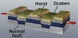
Graben
Encyclopedia
Geology
Geology is the science comprising the study of solid Earth, the rocks of which it is composed, and the processes by which it evolves. Geology gives insight into the history of the Earth, as it provides the primary evidence for plate tectonics, the evolutionary history of life, and past climates...
, a graben is a depressed
Depression (geology)
A depression in geology is a landform sunken or depressed below the surrounding area. Depressions may be formed by various mechanisms.Structural or tectonic related:...
block of land bordered by parallel faults. Graben is German
German language
German is a West Germanic language, related to and classified alongside English and Dutch. With an estimated 90 – 98 million native speakers, German is one of the world's major languages and is the most widely-spoken first language in the European Union....
for ditch. Graben is used for both the singular and plural.
A graben is the result of a block of land being downthrown producing a valley
Valley
In geology, a valley or dale is a depression with predominant extent in one direction. A very deep river valley may be called a canyon or gorge.The terms U-shaped and V-shaped are descriptive terms of geography to characterize the form of valleys...
with a distinct scarp
Escarpment
An escarpment is a steep slope or long cliff that occurs from erosion or faulting and separates two relatively level areas of differing elevations.-Description and variants:...
on each side. Graben often occur side-by-side with horsts. Horst and graben structures are indicative of tensional forces and crustal stretching.
Graben are produced from parallel normal faults, where the hanging wall is downthrown and the footwall is upthrown. The faults typically dip toward the center of the graben from both sides. Horsts are parallel blocks that remain between grabens, the bounding faults of a horst typically dip away from the center line of the horst.
Single or multiple graben can produce a rift valley
Rift valley
A rift valley is a linear-shaped lowland between highlands or mountain ranges created by the action of a geologic rift or fault. This action is manifest as crustal extension, a spreading apart of the surface which is subsequently further deepened by the forces of erosion...
.
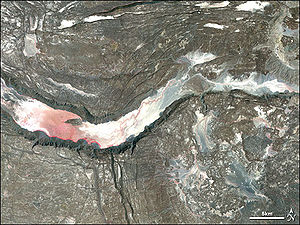
One of the world's deepest graben with over 1000 metres of downthrow is the Mount Unzen
Mount Unzen
is an active volcanic group of several overlapping stratovolcanoes, near the city of Shimabara, Nagasaki Prefecture, on the island of Kyūshū, Japan’s southernmost main island....
volcanic complex in southern Japan.
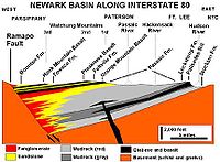
Half-graben
Sediment
Sediment is naturally occurring material that is broken down by processes of weathering and erosion, and is subsequently transported by the action of fluids such as wind, water, or ice, and/or by the force of gravity acting on the particle itself....
enters the half-graben across the main bounding fault, due to the effects of footwall uplift on the drainage systems. The exception is at any major offset in the bounding fault, where a relay ramp may provide an important sediment input point. Most of the sediment will enter the half-graben down the unfaulted hanging wall side (e.g. Lake Baikal
Lake Baikal
Lake Baikal is the world's oldest at 30 million years old and deepest lake with an average depth of 744.4 metres.Located in the south of the Russian region of Siberia, between Irkutsk Oblast to the northwest and the Buryat Republic to the southeast, it is the most voluminous freshwater lake in the...
).
Famous graben
- The Basin and Range Province of southwestern North AmericaNorth AmericaNorth America is a continent wholly within the Northern Hemisphere and almost wholly within the Western Hemisphere. It is also considered a northern subcontinent of the Americas...
is an example of multiple horst/graben structures, including Death ValleyDeath ValleyDeath Valley is a desert valley located in Eastern California. Situated within the Mojave Desert, it features the lowest, driest, and hottest locations in North America. Badwater, a basin located in Death Valley, is the specific location of the lowest elevation in North America at 282 feet below...
, with Salt Lake ValleySalt Lake ValleySalt Lake Valley is a valley in Salt Lake County in the north-central portion of the U.S. state of Utah. It contains Salt Lake City and many of its suburbs, notably West Valley City, Murray, Sandy, and West Jordan; its total population is 1,029,655 as of 2010...
being the easternmost and Owens ValleyOwens ValleyOwens Valley is the arid valley of the Owens River in eastern California in the United States, to the east of the Sierra Nevada and west of the White Mountains and Inyo Mountains on the west edge of the Great Basin section...
being the westernmost. - The Rio Grande RiftRio Grande RiftThe Rio Grande Rift is a north-trending continental rift zone. It separates the Colorado Plateau in the west from the interior of the North American craton on the east. The rift extends from central Colorado in the north to the state of Chihuahua, Mexico in the south. The rift zone consists of four...
Valley in ColoradoColoradoColorado is a U.S. state that encompasses much of the Rocky Mountains as well as the northeastern portion of the Colorado Plateau and the western edge of the Great Plains...
/New MexicoNew MexicoNew Mexico is a state located in the southwest and western regions of the United States. New Mexico is also usually considered one of the Mountain States. With a population density of 16 per square mile, New Mexico is the sixth-most sparsely inhabited U.S...
/TexasTexasTexas is the second largest U.S. state by both area and population, and the largest state by area in the contiguous United States.The name, based on the Caddo word "Tejas" meaning "friends" or "allies", was applied by the Spanish to the Caddo themselves and to the region of their settlement in...
of the United StatesUnited StatesThe United States of America is a federal constitutional republic comprising fifty states and a federal district... - The Rhine valleyUpper Rhine PlainThe Upper Rhine Plain, Rhine Rift Valley or Upper Rhine Graben is a major rift, straddling the border between France and Germany. It forms part of the European Cenozoic Rift System, which extends across central Europe...
to the north of BaselBaselBasel or Basle In the national languages of Switzerland the city is also known as Bâle , Basilea and Basilea is Switzerland's third most populous city with about 166,000 inhabitants. Located where the Swiss, French and German borders meet, Basel also has suburbs in France and Germany...
, SwitzerlandSwitzerlandSwitzerland name of one of the Swiss cantons. ; ; ; or ), in its full name the Swiss Confederation , is a federal republic consisting of 26 cantons, with Bern as the seat of the federal authorities. The country is situated in Western Europe,Or Central Europe depending on the definition.... - The Oslo grabenOslo GrabenThe Oslo Graben or Oslo Rift is a graben formed during a geologic rifting event in Permian time, the last phase of the Variscan orogeny. The main graben forming period began in the late Carboniferous, which culminated with rift formation and volcanism, with associated rhomb porphyry lava flows...
around OsloOsloOslo is a municipality, as well as the capital and most populous city in Norway. As a municipality , it was established on 1 January 1838. Founded around 1048 by King Harald III of Norway, the city was largely destroyed by fire in 1624. The city was moved under the reign of Denmark–Norway's King...
, NorwayNorwayNorway , officially the Kingdom of Norway, is a Nordic unitary constitutional monarchy whose territory comprises the western portion of the Scandinavian Peninsula, Jan Mayen, and the Arctic archipelago of Svalbard and Bouvet Island. Norway has a total area of and a population of about 4.9 million... - The East African RiftEast African RiftThe East African Rift is an active continental rift zone in eastern Africa that appears to be a developing divergent tectonic plate boundary. It is part of the larger Great Rift Valley. The rift is a narrow zone in which the African Plate is in the process of splitting into two new tectonic plates...
Valley - The Saguenay RiverSaguenay RiverThe Saguenay River is a major river of Quebec, Canada.It drains Lac Saint-Jean in the Laurentian Highlands, leaving at Alma and running east, and passes the city of Saguenay. It drains into the Saint Lawrence River at Tadoussac....
Valley, QuebecQuebecQuebec or is a province in east-central Canada. It is the only Canadian province with a predominantly French-speaking population and the only one whose sole official language is French at the provincial level....
, CanadaCanadaCanada is a North American country consisting of ten provinces and three territories. Located in the northern part of the continent, it extends from the Atlantic Ocean in the east to the Pacific Ocean in the west, and northward into the Arctic Ocean... - The Narmada RiverNarmada RiverThe Narmada , also called Rewa is a river in central India and the fifth largest river in the Indian subcontinent. It is the third largest river that completely flows within India after Ganges and Godavari...
valley in central India - The lower Godavari RiverGodavari RiverThe Godavari is a river that runs from western to southern India and is considered to be one of the big river basins in India. With a length of 1465 km, it is the second longest river in India , that runs within the country and also the longest river in South India...
valley in southern India - The Ottawa-Bonnechere GrabenOttawa-Bonnechere GrabenThe Ottawa-Bonnechere Graben , with its branch the Timiskaming Graben, is an ancient rift valley in the Canadian Shield of Northeastern Ontario and Quebec, Canada. This rift valley was formed when the Earth's crust moved downward about a kilometre between two major fault zones known as the Mattawa...
in OntarioOntarioOntario is a province of Canada, located in east-central Canada. It is Canada's most populous province and second largest in total area. It is home to the nation's most populous city, Toronto, and the nation's capital, Ottawa....
and Quebec, Canada - The Lambert Graben in Antarctica
- Gulf St Vincent in South AustraliaSouth AustraliaSouth Australia is a state of Australia in the southern central part of the country. It covers some of the most arid parts of the continent; with a total land area of , it is the fourth largest of Australia's six states and two territories.South Australia shares borders with all of the mainland...
, AustraliaAustraliaAustralia , officially the Commonwealth of Australia, is a country in the Southern Hemisphere comprising the mainland of the Australian continent, the island of Tasmania, and numerous smaller islands in the Indian and Pacific Oceans. It is the world's sixth-largest country by total area... - The Guanabara BayGuanabara BayGuanabara Bay is an oceanic bay located in southeastern Brazil in the state of Rio de Janeiro. On its western shore lies the city of Rio de Janeiro, and on its eastern shore the cities of Niterói and São Gonçalo. Four other municipalities surround the bay's shores...
in Rio de JaneiroRio de JaneiroRio de Janeiro , commonly referred to simply as Rio, is the capital city of the State of Rio de Janeiro, the second largest city of Brazil, and the third largest metropolitan area and agglomeration in South America, boasting approximately 6.3 million people within the city proper, making it the 6th...
, BrazilBrazilBrazil , officially the Federative Republic of Brazil , is the largest country in South America. It is the world's fifth largest country, both by geographical area and by population with over 192 million people... - The Central LowlandsCentral LowlandsThe Central Lowlands or Midland Valley is a geologically defined area of relatively low-lying land in southern Scotland. It consists of a rift valley between the Highland Boundary Fault to the north and the Southern Uplands Fault to the south...
(Midland Valley) of ScotlandScotlandScotland is a country that is part of the United Kingdom. Occupying the northern third of the island of Great Britain, it shares a border with England to the south and is bounded by the North Sea to the east, the Atlantic Ocean to the north and west, and the North Channel and Irish Sea to the... - Lake BaikalLake BaikalLake Baikal is the world's oldest at 30 million years old and deepest lake with an average depth of 744.4 metres.Located in the south of the Russian region of Siberia, between Irkutsk Oblast to the northwest and the Buryat Republic to the southeast, it is the most voluminous freshwater lake in the...
, SiberiaSiberiaSiberia is an extensive region constituting almost all of Northern Asia. Comprising the central and eastern portion of the Russian Federation, it was part of the Soviet Union from its beginning, as its predecessor states, the Tsardom of Russia and the Russian Empire, conquered it during the 16th...
, RussiaRussiaRussia or , officially known as both Russia and the Russian Federation , is a country in northern Eurasia. It is a federal semi-presidential republic, comprising 83 federal subjects... - Lake Tahoe, CA-NV