
Circle of latitude
Encyclopedia
A circle of latitude, on the Earth
, is an imaginary east
-west
circle connecting all locations (not taking into account elevation) that share a given latitude
. A location's position along a circle of latitude is given by its longitude
.
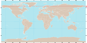
Circles of latitude are often called parallels because they are parallel to each other – that is, any two given parallels are everywhere the same distance apart. (Since the earth isn't spherical the distance from the equator to 10 degrees north is less than the distance from 10 to 20 degrees north.) On some map projections, including the Equirectangular projection
, they are drawn equidistant.
Circles of latitude become smaller the farther they are from the equator and the closer they are to the poles
. A circle of latitude is perpendicular to all meridian
s, and is hence a special case of a loxodrome.
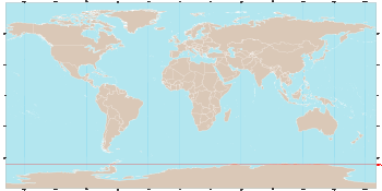
Contrary to what might be assumed from their straight-line representation on some map projections, a circle of latitude is not (except the Equator
) the shortest distance between two points lying on the Earth. In other words, circles of latitude (except for the Equator) are not great circle
s (see also great-circle distance
), but are rhumb line
s. For this reason an airplane traveling between a Europe
an and North America
n city that share the same latitude will fly farther north, over Greenland
for example.
Arcs of circles of latitude are sometimes used as boundaries between countries or regions where distinctive natural borders are lacking (such as in deserts), or when an artificial border is drawn as a "line on a map", as happened in Korea
.
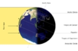
These circles of latitude, excluding the Equator, mark the divisions between the five principal geographical zone
s.
and South Pole
.
It divides the Earth into the Northern Hemisphere
and the Southern Hemisphere
.
Of the parallels
or circles of latitude, it is the longest, and the only 'great circle
' (in that it is a circle on the surface of the earth, centered on the center of the earth). All the other parallels are smaller and centered only on the earth's axis.
The latitude of these circles plus the Earth's axial tilt
is equal to 90°.
The latitude of the tropical circles is equal to the Earth's axial tilt
.
, Tropic of Capricorn
, Arctic Circle
and Antarctic Circle
all depend on the tilt of the Earth's axis
relative to the plane of its orbit around the sun, known technically as the "obliquity of the ecliptic". If the Earth were completely 'upright' (its axis at right angles to the orbital plane) there would be no Arctic, Antarctic, or Tropics : at the poles the sun would permanently circle the horizon ; and at the equator the sun would always rise due east, pass directly overhead, and set due west.
The positions of the Tropical and Polar circles are not fixed because the axial tilt changes slowly – a complex motion determined by the superimposition of many different cycles with short to very long periods. As of 2000, the mean value of the tilt was about 23° 26′ 21″.
The main long-term cycle causes the axial tilt to fluctuate between about 22.1° and 24.5° with a period of 41,000 years. Currently, the average value of the tilt is decreasing by about 0.47″ per year. As a result (approximately, and on average) the Tropical Circles are drifting towards the equator (and the Polar Circles towards the poles) by 15 metres per year, and the area of the Tropics
is decreasing by 1100 square km per year.
The Earth's axial tilt has additional shorter-term variations due to nutation
, of which the main term, with a period of 18.7 years, has an amplitude
of 9" 21
Finally, the Earth's rotational axis is not exactly fixed with respect to the Earth, but undergoes small fluctuations (on the order of 15 meters) called polar motion
, which have a small theoretical effect not only on the Tropics and Polar circles, but also on the Equator.
Short-term fluctuations over a matter of days do not directly affect the location of the extreme latitudes at which the sun may appear directly overhead, or at which 24-hour day or night is possible, except when they actually occur at the time of the solstices. Rather, they cause a theoretical shifting of the parallels, that would occur if the given axis tilt were maintained throughout the year.
s are defined by, or are approximated by, parallels.
Many section line boundaries and section line road
s run due east and due west along a circle of latitude, rather than a straight line.
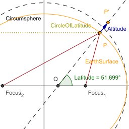 Altitude has an effect on a location's position relative to the plane
formed by a circle of latitude. Since altitude is determined by the normal
to the Earth's surface, locations sharing the same latitude—but having different elevations (e.g., lying along this normal)—no longer lie within this plane. Rather, all points sharing the same latitude and of varying elevation occupy a cone
formed by the rotation of this normal around the Earth's axis.
Earth
Earth is the third planet from the Sun, and the densest and fifth-largest of the eight planets in the Solar System. It is also the largest of the Solar System's four terrestrial planets...
, is an imaginary east
East
East is a noun, adjective, or adverb indicating direction or geography.East is one of the four cardinal directions or compass points. It is the opposite of west and is perpendicular to north and south.By convention, the right side of a map is east....
-west
West
West is a noun, adjective, or adverb indicating direction or geography.West is one of the four cardinal directions or compass points. It is the opposite of east and is perpendicular to north and south.By convention, the left side of a map is west....
circle connecting all locations (not taking into account elevation) that share a given latitude
Latitude
In geography, the latitude of a location on the Earth is the angular distance of that location south or north of the Equator. The latitude is an angle, and is usually measured in degrees . The equator has a latitude of 0°, the North pole has a latitude of 90° north , and the South pole has a...
. A location's position along a circle of latitude is given by its longitude
Longitude
Longitude is a geographic coordinate that specifies the east-west position of a point on the Earth's surface. It is an angular measurement, usually expressed in degrees, minutes and seconds, and denoted by the Greek letter lambda ....
.
Circles of latitude are often called parallels because they are parallel to each other – that is, any two given parallels are everywhere the same distance apart. (Since the earth isn't spherical the distance from the equator to 10 degrees north is less than the distance from 10 to 20 degrees north.) On some map projections, including the Equirectangular projection
Equirectangular projection
The equirectangular projection is a very simple map projection attributed to Marinus of Tyre, who Ptolemy claims invented the projection about AD 100...
, they are drawn equidistant.
Circles of latitude become smaller the farther they are from the equator and the closer they are to the poles
Geographical pole
A geographical pole is either of the two points—the north pole and the south pole—on the surface of a rotating planet where the axis of rotation meets the surface of the body...
. A circle of latitude is perpendicular to all meridian
Meridian (geography)
A meridian is an imaginary line on the Earth's surface from the North Pole to the South Pole that connects all locations along it with a given longitude. The position of a point along the meridian is given by its latitude. Each meridian is perpendicular to all circles of latitude...
s, and is hence a special case of a loxodrome.
Contrary to what might be assumed from their straight-line representation on some map projections, a circle of latitude is not (except the Equator
Equator
An equator is the intersection of a sphere's surface with the plane perpendicular to the sphere's axis of rotation and containing the sphere's center of mass....
) the shortest distance between two points lying on the Earth. In other words, circles of latitude (except for the Equator) are not great circle
Great circle
A great circle, also known as a Riemannian circle, of a sphere is the intersection of the sphere and a plane which passes through the center point of the sphere, as opposed to a general circle of a sphere where the plane is not required to pass through the center...
s (see also great-circle distance
Great-circle distance
The great-circle distance or orthodromic distance is the shortest distance between any two points on the surface of a sphere measured along a path on the surface of the sphere . Because spherical geometry is rather different from ordinary Euclidean geometry, the equations for distance take on a...
), but are rhumb line
Rhumb line
In navigation, a rhumb line is a line crossing all meridians of longitude at the same angle, i.e. a path derived from a defined initial bearing...
s. For this reason an airplane traveling between a Europe
Europe
Europe is, by convention, one of the world's seven continents. Comprising the westernmost peninsula of Eurasia, Europe is generally 'divided' from Asia to its east by the watershed divides of the Ural and Caucasus Mountains, the Ural River, the Caspian and Black Seas, and the waterways connecting...
an and North America
North America
North America is a continent wholly within the Northern Hemisphere and almost wholly within the Western Hemisphere. It is also considered a northern subcontinent of the Americas...
n city that share the same latitude will fly farther north, over Greenland
Greenland
Greenland is an autonomous country within the Kingdom of Denmark, located between the Arctic and Atlantic Oceans, east of the Canadian Arctic Archipelago. Though physiographically a part of the continent of North America, Greenland has been politically and culturally associated with Europe for...
for example.
Arcs of circles of latitude are sometimes used as boundaries between countries or regions where distinctive natural borders are lacking (such as in deserts), or when an artificial border is drawn as a "line on a map", as happened in Korea
38th parallel north
The 38th parallel north is a circle of latitude that is 38 degrees north of the Earth's equatorial plane. It crosses Europe, the Mediterranean Sea, Asia, the Pacific Ocean, North America, and the Atlantic Ocean...
.
Major circles of latitude
There are five major circles of latitude, listed below from north to south. The position of the Equator is fixed (90 degrees from the Earth's axis of rotation) but the other circles depends on the tilt of this axis relative to the plane of the Earth's orbit, and therefore are not perfectly fixed. The values below are for Epoch 2011.:- Arctic CircleArctic CircleThe Arctic Circle is one of the five major circles of latitude that mark maps of the Earth. For Epoch 2011, it is the parallel of latitude that runs north of the Equator....
( N) - Tropic of CancerTropic of CancerThe Tropic of Cancer, also referred to as the Northern tropic, is the circle of latitude on the Earth that marks the most northerly position at which the Sun may appear directly overhead at its zenith...
( N) - Equator (0° latitude)
- Tropic of CapricornTropic of CapricornThe Tropic of Capricorn, or Southern tropic, marks the most southerly latitude on the Earth at which the Sun can be directly overhead. This event occurs at the December solstice, when the southern hemisphere is tilted towards the Sun to its maximum extent.Tropic of Capricorn is one of the five...
( S) - Antarctic CircleAntarctic CircleThe Antarctic Circle is one of the five major circles of latitude that mark maps of the Earth. For 2011, it is the parallel of latitude that runs south of the Equator.-Description:...
( S)
These circles of latitude, excluding the Equator, mark the divisions between the five principal geographical zone
Geographical zone
The five main latitude regions of the Earth's surface comprise geographical zones, divided by the major circles of latitude. The differences between them relate to climate, and the behaviour of the Sun...
s.
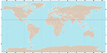
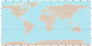
Equator
The equator is the circle that is equidistant from the North PoleNorth Pole
The North Pole, also known as the Geographic North Pole or Terrestrial North Pole, is, subject to the caveats explained below, defined as the point in the northern hemisphere where the Earth's axis of rotation meets its surface...
and South Pole
South Pole
The South Pole, also known as the Geographic South Pole or Terrestrial South Pole, is one of the two points where the Earth's axis of rotation intersects its surface. It is the southernmost point on the surface of the Earth and lies on the opposite side of the Earth from the North Pole...
.
It divides the Earth into the Northern Hemisphere
Northern Hemisphere
The Northern Hemisphere is the half of a planet that is north of its equator—the word hemisphere literally means “half sphere”. It is also that half of the celestial sphere north of the celestial equator...
and the Southern Hemisphere
Southern Hemisphere
The Southern Hemisphere is the part of Earth that lies south of the equator. The word hemisphere literally means 'half ball' or "half sphere"...
.
Of the parallels
Parallels
Parallels may refer to:* Circle of latitude , imaginary east-west circles connecting all locations that share a given latitude* "Parallels", the third track from the 1977 Yes album Going for the One...
or circles of latitude, it is the longest, and the only 'great circle
Great circle
A great circle, also known as a Riemannian circle, of a sphere is the intersection of the sphere and a plane which passes through the center point of the sphere, as opposed to a general circle of a sphere where the plane is not required to pass through the center...
' (in that it is a circle on the surface of the earth, centered on the center of the earth). All the other parallels are smaller and centered only on the earth's axis.
 |
| Equator Equator An equator is the intersection of a sphere's surface with the plane perpendicular to the sphere's axis of rotation and containing the sphere's center of mass.... |
Polar Circles
The Arctic Circle marks the northernmost latitude (in the Northern Hemisphere) at which the sun can remain continuously above or below the horizon for 24 hours. Similarly, the Antarctic Circle marks the southernmost latitude (in the Southern Hemisphere) at which the sun can remain continuously above or below the horizon for 24 hours.The latitude of these circles plus the Earth's axial tilt
Axial tilt
In astronomy, axial tilt is the angle between an object's rotational axis, and a line perpendicular to its orbital plane...
is equal to 90°.
|
|
Tropical Circles
The Tropic of Cancer and Tropic of Capricorn respectively mark the northernmost and southernmost latitudes at which the sun may be seen directly overhead (at the June solstice and December solstice respectively).The latitude of the tropical circles is equal to the Earth's axial tilt
Axial tilt
In astronomy, axial tilt is the angle between an object's rotational axis, and a line perpendicular to its orbital plane...
.
|
|
Movement of the Tropical and Polar circles
By definition, the positions of the Tropic of CancerTropic of Cancer
The Tropic of Cancer, also referred to as the Northern tropic, is the circle of latitude on the Earth that marks the most northerly position at which the Sun may appear directly overhead at its zenith...
, Tropic of Capricorn
Tropic of Capricorn
The Tropic of Capricorn, or Southern tropic, marks the most southerly latitude on the Earth at which the Sun can be directly overhead. This event occurs at the December solstice, when the southern hemisphere is tilted towards the Sun to its maximum extent.Tropic of Capricorn is one of the five...
, Arctic Circle
Arctic Circle
The Arctic Circle is one of the five major circles of latitude that mark maps of the Earth. For Epoch 2011, it is the parallel of latitude that runs north of the Equator....
and Antarctic Circle
Antarctic Circle
The Antarctic Circle is one of the five major circles of latitude that mark maps of the Earth. For 2011, it is the parallel of latitude that runs south of the Equator.-Description:...
all depend on the tilt of the Earth's axis
Axial tilt
In astronomy, axial tilt is the angle between an object's rotational axis, and a line perpendicular to its orbital plane...
relative to the plane of its orbit around the sun, known technically as the "obliquity of the ecliptic". If the Earth were completely 'upright' (its axis at right angles to the orbital plane) there would be no Arctic, Antarctic, or Tropics : at the poles the sun would permanently circle the horizon ; and at the equator the sun would always rise due east, pass directly overhead, and set due west.
The positions of the Tropical and Polar circles are not fixed because the axial tilt changes slowly – a complex motion determined by the superimposition of many different cycles with short to very long periods. As of 2000, the mean value of the tilt was about 23° 26′ 21″.
The main long-term cycle causes the axial tilt to fluctuate between about 22.1° and 24.5° with a period of 41,000 years. Currently, the average value of the tilt is decreasing by about 0.47″ per year. As a result (approximately, and on average) the Tropical Circles are drifting towards the equator (and the Polar Circles towards the poles) by 15 metres per year, and the area of the Tropics
Tropics
The tropics is a region of the Earth surrounding the Equator. It is limited in latitude by the Tropic of Cancer in the northern hemisphere at approximately N and the Tropic of Capricorn in the southern hemisphere at S; these latitudes correspond to the axial tilt of the Earth...
is decreasing by 1100 square km per year.
The Earth's axial tilt has additional shorter-term variations due to nutation
Nutation
Nutation is a rocking, swaying, or nodding motion in the axis of rotation of a largely axially symmetric object, such as a gyroscope, planet, or bullet in flight, or as an intended behavior of a mechanism...
, of which the main term, with a period of 18.7 years, has an amplitude
Amplitude
Amplitude is the magnitude of change in the oscillating variable with each oscillation within an oscillating system. For example, sound waves in air are oscillations in atmospheric pressure and their amplitudes are proportional to the change in pressure during one oscillation...
of 9" 21
Finally, the Earth's rotational axis is not exactly fixed with respect to the Earth, but undergoes small fluctuations (on the order of 15 meters) called polar motion
Polar motion
Polar motion of the earth is the movement of Earth's rotational axis across its surface. This is measured with respect to a reference frame in which the solid Earth is fixed...
, which have a small theoretical effect not only on the Tropics and Polar circles, but also on the Equator.
Short-term fluctuations over a matter of days do not directly affect the location of the extreme latitudes at which the sun may appear directly overhead, or at which 24-hour day or night is possible, except when they actually occur at the time of the solstices. Rather, they cause a theoretical shifting of the parallels, that would occur if the given axis tilt were maintained throughout the year.
Other notable parallels
A number of sub-national and international borderBorder
Borders define geographic boundaries of political entities or legal jurisdictions, such as governments, sovereign states, federated states and other subnational entities. Some borders—such as a state's internal administrative borders, or inter-state borders within the Schengen Area—are open and...
s are defined by, or are approximated by, parallels.
| Parallel | Description |
|---|---|
| 70°N 70th parallel north The 70th parallel north is a circle of latitude that is 70 degrees north of the Earth's equatorial plane, in the Arctic. It crosses the Atlantic Ocean, Europe, Asia and North America, and passes through some of the southern seas of the Arctic Ocean.... |
On Victoria Island, , two sections of the border between Northwest Territories Northwest Territories The Northwest Territories is a federal territory of Canada.Located in northern Canada, the territory borders Canada's two other territories, Yukon to the west and Nunavut to the east, and three provinces: British Columbia to the southwest, and Alberta and Saskatchewan to the south... and Nunavut Nunavut Nunavut is the largest and newest federal territory of Canada; it was separated officially from the Northwest Territories on April 1, 1999, via the Nunavut Act and the Nunavut Land Claims Agreement Act, though the actual boundaries had been established in 1993... . |
| 60°N 60th parallel north The 60th parallel north is a circle of latitude that is 60 degrees north of the Earth's equatorial plane. It crosses Europe, Asia, the Pacific Ocean, North America, and the Atlantic Ocean.... |
In , the southern border of Yukon Yukon Yukon is the westernmost and smallest of Canada's three federal territories. It was named after the Yukon River. The word Yukon means "Great River" in Gwich’in.... with the northern border of British Columbia British Columbia British Columbia is the westernmost of Canada's provinces and is known for its natural beauty, as reflected in its Latin motto, Splendor sine occasu . Its name was chosen by Queen Victoria in 1858... ; the southern border of Northwest Territories Northwest Territories The Northwest Territories is a federal territory of Canada.Located in northern Canada, the territory borders Canada's two other territories, Yukon to the west and Nunavut to the east, and three provinces: British Columbia to the southwest, and Alberta and Saskatchewan to the south... with the northern borders of British Columbia British Columbia British Columbia is the westernmost of Canada's provinces and is known for its natural beauty, as reflected in its Latin motto, Splendor sine occasu . Its name was chosen by Queen Victoria in 1858... , Alberta Alberta Alberta is a province of Canada. It had an estimated population of 3.7 million in 2010 making it the most populous of Canada's three prairie provinces... and Saskatchewan Saskatchewan Saskatchewan is a prairie province in Canada, which has an area of . Saskatchewan is bordered on the west by Alberta, on the north by the Northwest Territories, on the east by Manitoba, and on the south by the U.S. states of Montana and North Dakota.... ; and the southern border of mainland Nunavut Nunavut Nunavut is the largest and newest federal territory of Canada; it was separated officially from the Northwest Territories on April 1, 1999, via the Nunavut Act and the Nunavut Land Claims Agreement Act, though the actual boundaries had been established in 1993... with the northern border of Manitoba Manitoba Manitoba is a Canadian prairie province with an area of . The province has over 110,000 lakes and has a largely continental climate because of its flat topography. Agriculture, mostly concentrated in the fertile southern and western parts of the province, is vital to the province's economy; other... ), leading to the expression "north of sixty" for the territories. |
| 54°40'N | The border between 19th century Russian territories to the north and conflicting American and British land claims in western North America. The conflicting claims led to the Oregon boundary dispute Oregon boundary dispute The Oregon boundary dispute, or the Oregon Question, arose as a result of competing British and American claims to the Pacific Northwest of North America in the first half of the 19th century. Both the United Kingdom and the United States had territorial and commercial aspirations in the region... between Britain and the United States, giving rise to the slogan "Fifty-four forty or fight." |
| 52°N 52nd parallel north The 52nd parallel north is a circle of latitude that is 52 degrees north of the Earth's equatorial plane. It crosses Europe, Asia, the Pacific Ocean, North America, and the Atlantic Ocean.... |
In , part of the border between Newfoundland and Labrador Newfoundland and Labrador Newfoundland and Labrador is the easternmost province of Canada. Situated in the country's Atlantic region, it incorporates the island of Newfoundland and mainland Labrador with a combined area of . As of April 2011, the province's estimated population is 508,400... and Quebec Quebec Quebec or is a province in east-central Canada. It is the only Canadian province with a predominantly French-speaking population and the only one whose sole official language is French at the provincial level.... . |
| 51°N 51st parallel north The 51st parallel north is a circle of latitude that is 51 degrees north of the Earth's equatorial plane. It crosses Europe, Asia, the Pacific Ocean, North America, and the Atlantic Ocean.... |
The southern limit of Russian America from 1799 to 1821. |
| 49°N 49th parallel north The 49th parallel north is a circle of latitude that is 49 degrees north of the Earth's equatorial plane. It crosses Europe, Asia, the Pacific Ocean, North America, and the Atlantic Ocean.... |
Much of the border between and the , from British Columbia British Columbia British Columbia is the westernmost of Canada's provinces and is known for its natural beauty, as reflected in its Latin motto, Splendor sine occasu . Its name was chosen by Queen Victoria in 1858... to Manitoba Manitoba Manitoba is a Canadian prairie province with an area of . The province has over 110,000 lakes and has a largely continental climate because of its flat topography. Agriculture, mostly concentrated in the fertile southern and western parts of the province, is vital to the province's economy; other... ; "49th parallel" is a common expression for the border, though a large majority of Canada's population actually lives south of the parallel. |
| 48°N 48th parallel north The 48th parallel north is a circle of latitude that is 48 degrees north of the Earth's equatorial plane. It crosses Europe, Asia, the Pacific Ocean, North America, and the Atlantic Ocean.... |
In , part of the border between Quebec Quebec Quebec or is a province in east-central Canada. It is the only Canadian province with a predominantly French-speaking population and the only one whose sole official language is French at the provincial level.... and New Brunswick New Brunswick New Brunswick is one of Canada's three Maritime provinces and is the only province in the federation that is constitutionally bilingual . The provincial capital is Fredericton and Saint John is the most populous city. Greater Moncton is the largest Census Metropolitan Area... . |
| 46°N 46th parallel north The 46th parallel north is a circle of latitude that is 46 degrees north of the Earth's equatorial plane. It crosses Europe, Asia, the Pacific Ocean, North America, and the Atlantic Ocean.... |
In the , part of the border between Washington and Oregon Oregon Oregon is a state in the Pacific Northwest region of the United States. It is located on the Pacific coast, with Washington to the north, California to the south, Nevada on the southeast and Idaho to the east. The Columbia and Snake rivers delineate much of Oregon's northern and eastern... . |
| 45°N | Part of the border between (Quebec Quebec Quebec or is a province in east-central Canada. It is the only Canadian province with a predominantly French-speaking population and the only one whose sole official language is French at the provincial level.... ) and the (New York New York New York is a state in the Northeastern region of the United States. It is the nation's third most populous state. New York is bordered by New Jersey and Pennsylvania to the south, and by Connecticut, Massachusetts and Vermont to the east... and Vermont Vermont Vermont is a state in the New England region of the northeastern United States of America. The state ranks 43rd in land area, , and 45th in total area. Its population according to the 2010 census, 630,337, is the second smallest in the country, larger only than Wyoming. It is the only New England... ). Also, in the , most of the border between Montana Montana Montana is a state in the Western United States. The western third of Montana contains numerous mountain ranges. Smaller, "island ranges" are found in the central third of the state, for a total of 77 named ranges of the Rocky Mountains. This geographical fact is reflected in the state's name,... and Wyoming Wyoming Wyoming is a state in the mountain region of the Western United States. The western two thirds of the state is covered mostly with the mountain ranges and rangelands in the foothills of the Eastern Rocky Mountains, while the eastern third of the state is high elevation prairie known as the High... . |
| 43°N 43rd parallel north The 43rd parallel north is a circle of latitude that is 43 degrees north of the Earth's equatorial plane. It crosses Europe, the Mediterranean Sea, Asia, the Pacific Ocean, North America, and the Atlantic Ocean.... |
In the , much of the border between South Dakota South Dakota South Dakota is a state located in the Midwestern region of the United States. It is named after the Lakota and Dakota Sioux American Indian tribes. Once a part of Dakota Territory, South Dakota became a state on November 2, 1889. The state has an area of and an estimated population of just over... and Nebraska Nebraska Nebraska is a state on the Great Plains of the Midwestern United States. The state's capital is Lincoln and its largest city is Omaha, on the Missouri River.... . |
| 42°N 42nd parallel north The 42nd parallel north is a circle of latitude that is 42 degrees north of the Earth's equatorial plane. It crosses Europe, the Mediterranean Sea, Asia, the Pacific Ocean, North America, and the Atlantic Ocean.... |
Originally the northward limit of New Spain New Spain New Spain, formally called the Viceroyalty of New Spain , was a viceroyalty of the Spanish colonial empire, comprising primarily territories in what was known then as 'América Septentrional' or North America. Its capital was Mexico City, formerly Tenochtitlan, capital of the Aztec Empire... . In the , the southern borders of Oregon Oregon Oregon is a state in the Pacific Northwest region of the United States. It is located on the Pacific coast, with Washington to the north, California to the south, Nevada on the southeast and Idaho to the east. The Columbia and Snake rivers delineate much of Oregon's northern and eastern... and Idaho Idaho Idaho is a state in the Rocky Mountain area of the United States. The state's largest city and capital is Boise. Residents are called "Idahoans". Idaho was admitted to the Union on July 3, 1890, as the 43rd state.... where they meet the northern borders of California California California is a state located on the West Coast of the United States. It is by far the most populous U.S. state, and the third-largest by land area... , Nevada Nevada Nevada is a state in the western, mountain west, and southwestern regions of the United States. With an area of and a population of about 2.7 million, it is the 7th-largest and 35th-most populous state. Over two-thirds of Nevada's people live in the Las Vegas metropolitan area, which contains its... and Utah Utah Utah is a state in the Western United States. It was the 45th state to join the Union, on January 4, 1896. Approximately 80% of Utah's 2,763,885 people live along the Wasatch Front, centering on Salt Lake City. This leaves vast expanses of the state nearly uninhabited, making the population the... . The parallel also defines much of the border between Pennsylvania Pennsylvania The Commonwealth of Pennsylvania is a U.S. state that is located in the Northeastern and Mid-Atlantic regions of the United States. The state borders Delaware and Maryland to the south, West Virginia to the southwest, Ohio to the west, New York and Ontario, Canada, to the north, and New Jersey to... and New York New York New York is a state in the Northeastern region of the United States. It is the nation's third most populous state. New York is bordered by New Jersey and Pennsylvania to the south, and by Connecticut, Massachusetts and Vermont to the east... . |
| 41°N 41st parallel north The 41st parallel north is a circle of latitude that is 41 degrees north of the Earth's equatorial plane. It crosses Europe, the Mediterranean Sea, Asia, the Pacific Ocean, North America, and the Atlantic Ocean.... |
In the , part of the border between Wyoming Wyoming Wyoming is a state in the mountain region of the Western United States. The western two thirds of the state is covered mostly with the mountain ranges and rangelands in the foothills of the Eastern Rocky Mountains, while the eastern third of the state is high elevation prairie known as the High... and Utah Utah Utah is a state in the Western United States. It was the 45th state to join the Union, on January 4, 1896. Approximately 80% of Utah's 2,763,885 people live along the Wasatch Front, centering on Salt Lake City. This leaves vast expanses of the state nearly uninhabited, making the population the... , the border between Wyoming Wyoming Wyoming is a state in the mountain region of the Western United States. The western two thirds of the state is covered mostly with the mountain ranges and rangelands in the foothills of the Eastern Rocky Mountains, while the eastern third of the state is high elevation prairie known as the High... and Colorado Colorado Colorado is a U.S. state that encompasses much of the Rocky Mountains as well as the northeastern portion of the Colorado Plateau and the western edge of the Great Plains... , and part of the border between Nebraska Nebraska Nebraska is a state on the Great Plains of the Midwestern United States. The state's capital is Lincoln and its largest city is Omaha, on the Missouri River.... and Colorado Colorado Colorado is a U.S. state that encompasses much of the Rocky Mountains as well as the northeastern portion of the Colorado Plateau and the western edge of the Great Plains... . |
| 40°N 40th parallel north The 40th parallel north is a circle of latitude that is 40 degrees north of the Earth's equatorial plane. It crosses Europe, the Mediterranean Sea, Asia, the Pacific Ocean, North America, and the Atlantic Ocean.... |
In the , the border between Nebraska Nebraska Nebraska is a state on the Great Plains of the Midwestern United States. The state's capital is Lincoln and its largest city is Omaha, on the Missouri River.... and Kansas Kansas Kansas is a US state located in the Midwestern United States. It is named after the Kansas River which flows through it, which in turn was named after the Kansa Native American tribe, which inhabited the area. The tribe's name is often said to mean "people of the wind" or "people of the south... . The parallel was originally chosen for the Mason-Dixon Line Mason-Dixon line The Mason–Dixon Line was surveyed between 1763 and 1767 by Charles Mason and Jeremiah Dixon in the resolution of a border dispute between British colonies in Colonial America. It forms a demarcation line among four U.S. states, forming part of the borders of Pennsylvania, Maryland, Delaware, and... , but the line was moved several miles south to avoid bisecting the city of Philadelphia. |
| 38°N 38th parallel north The 38th parallel north is a circle of latitude that is 38 degrees north of the Earth's equatorial plane. It crosses Europe, the Mediterranean Sea, Asia, the Pacific Ocean, North America, and the Atlantic Ocean... |
The boundary between the Soviet Soviet Union The Soviet Union , officially the Union of Soviet Socialist Republics , was a constitutionally socialist state that existed in Eurasia between 1922 and 1991.... and American occupation zones in Korea Korea Korea ) is an East Asian geographic region that is currently divided into two separate sovereign states — North Korea and South Korea. Located on the Korean Peninsula, Korea is bordered by the People's Republic of China to the northwest, Russia to the northeast, and is separated from Japan to the... from 1945 until Korean War Korean War The Korean War was a conventional war between South Korea, supported by the United Nations, and North Korea, supported by the People's Republic of China , with military material aid from the Soviet Union... (1950–1953). |
| 37°N 37th parallel north The 37th parallel north is a circle of latitude that is 37 degrees north of the Earth's equatorial plane. It crosses Europe, the Mediterranean Sea, Africa, Asia, the Pacific Ocean, North America, and the Atlantic Ocean.... |
In the , the southern border of Utah Utah Utah is a state in the Western United States. It was the 45th state to join the Union, on January 4, 1896. Approximately 80% of Utah's 2,763,885 people live along the Wasatch Front, centering on Salt Lake City. This leaves vast expanses of the state nearly uninhabited, making the population the... with the northern border of Arizona Arizona Arizona ; is a state located in the southwestern region of the United States. It is also part of the western United States and the mountain west. The capital and largest city is Phoenix... . The southern border of Colorado Colorado Colorado is a U.S. state that encompasses much of the Rocky Mountains as well as the northeastern portion of the Colorado Plateau and the western edge of the Great Plains... with the northern borders of New Mexico New Mexico New Mexico is a state located in the southwest and western regions of the United States. New Mexico is also usually considered one of the Mountain States. With a population density of 16 per square mile, New Mexico is the sixth-most sparsely inhabited U.S... and Oklahoma Oklahoma Oklahoma is a state located in the South Central region of the United States of America. With an estimated 3,751,351 residents as of the 2010 census and a land area of 68,667 square miles , Oklahoma is the 28th most populous and 20th-largest state... . The southern border of Kansas Kansas Kansas is a US state located in the Midwestern United States. It is named after the Kansas River which flows through it, which in turn was named after the Kansa Native American tribe, which inhabited the area. The tribe's name is often said to mean "people of the wind" or "people of the south... with the northern border of Oklahoma Oklahoma Oklahoma is a state located in the South Central region of the United States of America. With an estimated 3,751,351 residents as of the 2010 census and a land area of 68,667 square miles , Oklahoma is the 28th most populous and 20th-largest state... . |
| 36°30'N | The historic Missouri Compromise Missouri Compromise The Missouri Compromise was an agreement passed in 1820 between the pro-slavery and anti-slavery factions in the United States Congress, involving primarily the regulation of slavery in the western territories. It prohibited slavery in the former Louisiana Territory north of the parallel 36°30'... line. In the , defines part of the border between Oklahoma Oklahoma Oklahoma is a state located in the South Central region of the United States of America. With an estimated 3,751,351 residents as of the 2010 census and a land area of 68,667 square miles , Oklahoma is the 28th most populous and 20th-largest state... and Texas Texas Texas is the second largest U.S. state by both area and population, and the largest state by area in the contiguous United States.The name, based on the Caddo word "Tejas" meaning "friends" or "allies", was applied by the Spanish to the Caddo themselves and to the region of their settlement in... , most of the border between Missouri Missouri Missouri is a US state located in the Midwestern United States, bordered by Iowa, Illinois, Kentucky, Tennessee, Arkansas, Oklahoma, Kansas and Nebraska. With a 2010 population of 5,988,927, Missouri is the 18th most populous state in the nation and the fifth most populous in the Midwest. It... and Arkansas Arkansas Arkansas is a state located in the southern region of the United States. Its name is an Algonquian name of the Quapaw Indians. Arkansas shares borders with six states , and its eastern border is largely defined by the Mississippi River... . Geographically it is a Westward extension of the border between Virginia Virginia The Commonwealth of Virginia , is a U.S. state on the Atlantic Coast of the Southern United States. Virginia is nicknamed the "Old Dominion" and sometimes the "Mother of Presidents" after the eight U.S. presidents born there... and North Carolina North Carolina North Carolina is a state located in the southeastern United States. The state borders South Carolina and Georgia to the south, Tennessee to the west and Virginia to the north. North Carolina contains 100 counties. Its capital is Raleigh, and its largest city is Charlotte... and part of the border between Kentucky Kentucky The Commonwealth of Kentucky is a state located in the East Central United States of America. As classified by the United States Census Bureau, Kentucky is a Southern state, more specifically in the East South Central region. Kentucky is one of four U.S. states constituted as a commonwealth... and Tennessee Tennessee Tennessee is a U.S. state located in the Southeastern United States. It has a population of 6,346,105, making it the nation's 17th-largest state by population, and covers , making it the 36th-largest by total land area... . |
| 36°N 36th parallel north The 36th parallel north is a circle of latitude that is 36 degrees north of the Earth's equatorial plane. It crosses Africa, the Mediterranean Sea, Asia, the Pacific Ocean, North America and the Atlantic Ocean.... |
In the , a short section of the border between the Missouri Bootheel and Arkansas Arkansas Arkansas is a state located in the southern region of the United States. Its name is an Algonquian name of the Quapaw Indians. Arkansas shares borders with six states , and its eastern border is largely defined by the Mississippi River... . |
| 35°N 35th parallel north The 35th parallel north is a circle of latitude that is 35 degrees north of the Earth's equatorial plane. It crosses Africa, the Mediterranean Sea, Asia, the Pacific Ocean, North America and the Atlantic Ocean.... |
In the , the southern border of Tennessee Tennessee Tennessee is a U.S. state located in the Southeastern United States. It has a population of 6,346,105, making it the nation's 17th-largest state by population, and covers , making it the 36th-largest by total land area... , which meets Mississippi Mississippi Mississippi is a U.S. state located in the Southern United States. Jackson is the state capital and largest city. The name of the state derives from the Mississippi River, which flows along its western boundary, whose name comes from the Ojibwe word misi-ziibi... , Alabama Alabama Alabama is a state located in the southeastern region of the United States. It is bordered by Tennessee to the north, Georgia to the east, Florida and the Gulf of Mexico to the south, and Mississippi to the west. Alabama ranks 30th in total land area and ranks second in the size of its inland... and Georgia Georgia (U.S. state) Georgia is a state located in the southeastern United States. It was established in 1732, the last of the original Thirteen Colonies. The state is named after King George II of Great Britain. Georgia was the fourth state to ratify the United States Constitution, on January 2, 1788... . Also, part of the border between North Carolina North Carolina North Carolina is a state located in the southeastern United States. The state borders South Carolina and Georgia to the south, Tennessee to the west and Virginia to the north. North Carolina contains 100 counties. Its capital is Raleigh, and its largest city is Charlotte... and Georgia Georgia (U.S. state) Georgia is a state located in the southeastern United States. It was established in 1732, the last of the original Thirteen Colonies. The state is named after King George II of Great Britain. Georgia was the fourth state to ratify the United States Constitution, on January 2, 1788... . |
| 33°N 33rd parallel north The 33rd parallel north is a circle of latitude that is 33 degrees north of the Earth's equatorial plane. It crosses Africa, Asia, the Pacific Ocean, North America and the Atlantic Ocean.... |
In the , the southern border of Arkansas Arkansas Arkansas is a state located in the southern region of the United States. Its name is an Algonquian name of the Quapaw Indians. Arkansas shares borders with six states , and its eastern border is largely defined by the Mississippi River... , which meets the northern border of Louisiana Louisiana Louisiana is a state located in the southern region of the United States of America. Its capital is Baton Rouge and largest city is New Orleans. Louisiana is the only state in the U.S. with political subdivisions termed parishes, which are local governments equivalent to counties... . Historically, it defined the southern border of the Louisiana Territory Louisiana Territory The Territory of Louisiana or Louisiana Territory was an organized incorporated territory of the United States that existed from July 4, 1805 until June 4, 1812, when it was renamed to Missouri Territory... . |
| 32°N 32nd parallel north The 32nd parallel north is a circle of latitude that is 32 degrees north of the Earth's equatorial plane. It crosses Africa, Asia, the Pacific Ocean, North America and the Atlantic Ocean.... |
In the , part of the border between New Mexico New Mexico New Mexico is a state located in the southwest and western regions of the United States. New Mexico is also usually considered one of the Mountain States. With a population density of 16 per square mile, New Mexico is the sixth-most sparsely inhabited U.S... and Texas Texas Texas is the second largest U.S. state by both area and population, and the largest state by area in the contiguous United States.The name, based on the Caddo word "Tejas" meaning "friends" or "allies", was applied by the Spanish to the Caddo themselves and to the region of their settlement in... . |
| 31°N 31st parallel north The 31st parallel north is a circle of latitude that is 31 degrees north of the Earth's equatorial plane. It crosses Africa, Asia, the Pacific Ocean, North America and the Atlantic Ocean.Part of the border between Iran and Iraq is defined by the parallel.... |
Part of the border between and . In the , part of the border between Mississippi Mississippi Mississippi is a U.S. state located in the Southern United States. Jackson is the state capital and largest city. The name of the state derives from the Mississippi River, which flows along its western boundary, whose name comes from the Ojibwe word misi-ziibi... and Louisiana Louisiana Louisiana is a state located in the southern region of the United States of America. Its capital is Baton Rouge and largest city is New Orleans. Louisiana is the only state in the U.S. with political subdivisions termed parishes, which are local governments equivalent to counties... , and part of the border between Alabama Alabama Alabama is a state located in the southeastern region of the United States. It is bordered by Tennessee to the north, Georgia to the east, Florida and the Gulf of Mexico to the south, and Mississippi to the west. Alabama ranks 30th in total land area and ranks second in the size of its inland... and Florida Florida Florida is a state in the southeastern United States, located on the nation's Atlantic and Gulf coasts. It is bordered to the west by the Gulf of Mexico, to the north by Alabama and Georgia and to the east by the Atlantic Ocean. With a population of 18,801,310 as measured by the 2010 census, it... . |
| 28°N 28th parallel north The 28th parallel north is a circle of latitude that is 28 degrees north of the Earth's equatorial plane. It crosses Africa, Asia, the Pacific Ocean, North America and the Atlantic Ocean.... |
In , the border between Baja California Baja California Baja California officially Estado Libre y Soberano de Baja California is one of the 31 states which, with the Federal District, comprise the 32 Federal Entities of Mexico. It is both the northernmost and westernmost state of Mexico. Before becoming a state in 1953, the area was known as the North... and Baja California Sur Baja California Sur Baja California Sur , is one of the 31 states which, with the Federal District, comprise the 32 Federal Entities of Mexico. Before becoming a state on October 8, 1974, the area was known as the South Territory of Baja California. It has an area of , or 3.57% of the land mass of Mexico and comprises... . |
| 26°N 26th parallel north The 26th parallel north is a circle of latitude that is 26 degrees north of the Earth's equatorial plane. It crosses Africa, Asia, the Indian Ocean, the Pacific Ocean, North America and the Atlantic Ocean.... |
Part of the border between Western Sahara Western Sahara Western Sahara is a disputed territory in North Africa, bordered by Morocco to the north, Algeria to the northeast, Mauritania to the east and south, and the Atlantic Ocean to the west. Its surface area amounts to . It is one of the most sparsely populated territories in the world, mainly... (claimed by ) and . |
| 25°N 25th parallel north The 25th parallel north is a circle of latitude that is 25 degrees north of the Earth's equatorial plane. It crosses Africa, Asia, the Indian Ocean, the Pacific Ocean, North America and the Atlantic Ocean.... |
Part of the border between and . |
| 22°N 22nd parallel north The 22nd parallel north is a circle of latitude that is 22 degrees north of the Earth's equatorial plane. It crosses Africa, Asia, the Indian Ocean, the Pacific Ocean, North America, the Caribbean and the Atlantic Ocean.... |
Much of the border between and , partly disputed (see also Hala'ib Triangle Hala'ib Triangle The Hala'ib Triangle is an area of land measuring located on the Red Sea's African coast... ). |
| 20°N 20th parallel north The 20th parallel north is a circle of latitude that is 20 degrees north of the Earth's equatorial plane. It crosses Africa, Asia, the Indian Ocean, the Pacific Ocean, North America, the Caribbean and the Atlantic Ocean.... |
A short section of the border between and , and within Sudan, the northern border of the Darfur Darfur Darfur is a region in western Sudan. An independent sultanate for several hundred years, it was incorporated into Sudan by Anglo-Egyptian forces in 1916. The region is divided into three federal states: West Darfur, South Darfur, and North Darfur... region. |
| 17°N 17th parallel north The 17th parallel north is a circle of latitude that is 17 degrees north of the Earth's equatorial plane. It crosses Africa, Asia, the Indian Ocean, the Pacific Ocean, Central America, the Caribbean and the Atlantic Ocean.... |
The division between Republic of Vietnam (South Vietnam) and Democratic Republic of Vietnam (North Vietnam) during the Vietnam War Vietnam War The Vietnam War was a Cold War-era military conflict that occurred in Vietnam, Laos, and Cambodia from 1 November 1955 to the fall of Saigon on 30 April 1975. This war followed the First Indochina War and was fought between North Vietnam, supported by its communist allies, and the government of... . |
| 15°N 15th parallel north The 15th parallel north is a circle of latitude that is 15 degrees north of the Earth's equatorial plane. It crosses Africa, Asia, the Indian Ocean, the Pacific Ocean, Central America, the Caribbean and the Atlantic Ocean.... |
de facto maritime border between and . |
| 13°05'N | Part of the border between and , over a stretch of 41.6 km, partly in Lake Chad Lake Chad Lake Chad is a historically large, shallow, endorheic lake in Africa, whose size has varied over the centuries. According to the Global Resource Information Database of the United Nations Environment Programme, it shrank as much as 95% from about 1963 to 1998; yet it also states that "the 2007 ... |
| 10°N 10th parallel north The 10th parallel north is a circle of latitude that is 10 degrees north of the Earth's equatorial plane. It crosses Africa, the Indian Ocean, South Asia, Southeast Asia, the Pacific Ocean, Central America, South America and the Atlantic Ocean.... |
Part of the border between and . |
| 8°N 8th parallel north The 8th parallel north is a circle of latitude that is 8 degrees north of the Earth's equatorial plane. It crosses Africa, the Indian Ocean, South Asia, Southeast Asia, the Pacific Ocean, Central America, South America and the Atlantic Ocean.... |
Part of the border between and . |
| 1°N 1st parallel north The 1st parallel north is a circle of latitude that is 1 degree north of the Earth's equatorial plane. It crosses the Atlantic Ocean, Africa, the Indian Ocean, Southeast Asia, the Pacific Ocean and South America.... |
Part of the border between and . |
| 1°S 1st parallel south The 1st parallel south is a circle of latitude that is 1 degree south of the Earth's equatorial plane. It crosses the Atlantic Ocean, Africa, the Indian Ocean, Southeast Asia, Australasia, the Pacific Ocean and South America.... |
Most of the border between and , and a very short section of the border between and in Lake Victoria Lake Victoria Lake Victoria is one of the African Great Lakes. The lake was named for Queen Victoria of the United Kingdom, by John Hanning Speke, the first European to discover this lake.... . |
| 7°S 7th parallel south The 7th parallel south is a circle of latitude that is 7 degrees south of the Earth's equatorial plane. It crosses the Atlantic Ocean, Africa, the Indian Ocean, Southeast Asia, Australasia, the Pacific Ocean and South America.... |
A short section of the border between and . |
| 8°S 8th parallel south The 8th parallel south is a circle of latitude that is 8 degrees south of the Earth's equatorial plane. It crosses the Atlantic Ocean, Africa, the Indian Ocean, Southeast Asia, Australasia, the Pacific Ocean and South America.... |
Two short sections of the border between and . |
| 10°S 10th parallel south The 10th parallel south is a circle of latitude that is 10 degrees south of the Earth's equatorial plane. It crosses the Atlantic Ocean, Africa, the Indian Ocean, Australasia, the Pacific Ocean and South America.... |
A short section of the border between and . |
| 13°S 13th parallel south The 13th parallel south is a circle of latitude that is 13 degrees south of the Earth's equatorial plane. It crosses the Atlantic Ocean, Africa, the Indian Ocean, Australasia, the Pacific Ocean and South America.... |
Part of the border between and . |
| 16°S 16th parallel south The 16th parallel south is a circle of latitude that is 16 degrees south of the Earth's equatorial plane. It crosses the Atlantic Ocean, Africa, the Indian Ocean, Australasia, the Pacific Ocean and South America.... |
Part of the border between and . |
| 22°S 22nd parallel south The 22nd parallel south is a circle of latitude that is 22 degrees south of the Earth's equatorial plane. It crosses the Atlantic Ocean, Africa, the Indian Ocean, Australasia, the Pacific Ocean and South America.... |
A short section of the border between and , and parts of the border between and . |
| 26°S 26th parallel south The 26th parallel south is a circle of latitude that is 26 degrees south of the Earth's equatorial plane. It crosses the Atlantic Ocean, Africa, the Indian Ocean, Australasia, the Pacific Ocean and South America.... |
In , the border between South Australia South Australia South Australia is a state of Australia in the southern central part of the country. It covers some of the most arid parts of the continent; with a total land area of , it is the fourth largest of Australia's six states and two territories.South Australia shares borders with all of the mainland... and the Northern Territory Northern Territory The Northern Territory is a federal territory of Australia, occupying much of the centre of the mainland continent, as well as the central northern regions... , and part of the border between South Australia South Australia South Australia is a state of Australia in the southern central part of the country. It covers some of the most arid parts of the continent; with a total land area of , it is the fourth largest of Australia's six states and two territories.South Australia shares borders with all of the mainland... and Queensland Queensland Queensland is a state of Australia, occupying the north-eastern section of the mainland continent. It is bordered by the Northern Territory, South Australia and New South Wales to the west, south-west and south respectively. To the east, Queensland is bordered by the Coral Sea and Pacific Ocean... . |
| 28°S 28th parallel south The 28th parallel south is a circle of latitude that is 28 degrees south of the Earth's equatorial plane. It crosses the Atlantic Ocean, Africa, the Indian Ocean, Australasia, the Pacific Ocean and South America.... |
In , the border between Chaco Province Chaco Province Chaco is an Argentine province located in the north of the country, near the border with Paraguay. Its capital is Resistencia on the Paraná River opposite the city of Corrientes... and Santa Fe Province Santa Fe Province The Invincible Province of Santa Fe, in Spanish Provincia Invencible de Santa Fe , is a province of Argentina, located in the center-east of the country. Neighboring provinces are from the north clockwise Chaco , Corrientes, Entre Ríos, Buenos Aires, Córdoba, and Santiago del Estero... . |
| 29°S 29th parallel south The 29th parallel south is a circle of latitude that is 29 degrees south of the Earth's equatorial plane. It crosses the Atlantic Ocean, Africa, the Indian Ocean, Australasia, the Pacific Ocean and South America.... |
In , much of the border between Queensland Queensland Queensland is a state of Australia, occupying the north-eastern section of the mainland continent. It is bordered by the Northern Territory, South Australia and New South Wales to the west, south-west and south respectively. To the east, Queensland is bordered by the Coral Sea and Pacific Ocean... and New South Wales New South Wales New South Wales is a state of :Australia, located in the east of the country. It is bordered by Queensland, Victoria and South Australia to the north, south and west respectively. To the east, the state is bordered by the Tasman Sea, which forms part of the Pacific Ocean. New South Wales... . |
| 35°S 35th parallel south The 35th parallel south is a circle of latitude that is 35 degrees south of the Earth's equatorial plane. It crosses the Atlantic Ocean, the Indian Ocean, Australasia, the Pacific Ocean and South America.... |
In , part of the border between Córdoba Province and La Pampa Province La Pampa Province La Pampa is a sparsely populated province of Argentina, located in the Pampas in the center of the country. Neighboring provinces are from the north clockwise San Luis, Córdoba, Buenos Aires, Río Negro, Neuquén and Mendoza.-History:... . |
| 36°S 36th parallel south The 36th parallel south is a circle of latitude that is 36 degrees south of the Earth's equatorial plane. It crosses the Atlantic Ocean, the Indian Ocean, Australasia, the Pacific Ocean and South America.... |
In , part of the border between Mendoza Province Mendoza Province The Province of Mendoza is a province of Argentina, located in the western central part of the country in the Cuyo region. It borders to the north with San Juan, the south with La Pampa and Neuquén, the east with San Luis, and to the west with the republic of Chile; the international limit is... and La Pampa Province La Pampa Province La Pampa is a sparsely populated province of Argentina, located in the Pampas in the center of the country. Neighboring provinces are from the north clockwise San Luis, Córdoba, Buenos Aires, Río Negro, Neuquén and Mendoza.-History:... . |
| 42°S 42nd parallel south The 42nd parallel south is a circle of latitude that is 42 degrees south of the Earth's equatorial plane. It crosses the Atlantic Ocean, the Indian Ocean, Australasia, the Pacific Ocean and South America.... |
In , the border between Río Negro Province Río Negro Province Río Negro is a province of Argentina, located at the northern edge of Patagonia. Neighboring provinces are from the south clockwise Chubut, Neuquén, Mendoza, La Pampa and Buenos Aires. To the east lies the Atlantic Ocean.Its capital is Viedma... and Chubut Province Chubut Province Chubut a province in the southern part of Argentina situated between the 42nd parallel south and the 46th parallel south , the Andes range separating Argentina from Chile, and the Atlantic ocean... . |
| 46°S 46th parallel south The 46th parallel south is a circle of latitude that is 46 degrees south of the Earth's equatorial plane. It crosses the Atlantic Ocean, the Indian Ocean, Australasia, the Pacific Ocean and South America.... |
In , the border between Chubut Province Chubut Province Chubut a province in the southern part of Argentina situated between the 42nd parallel south and the 46th parallel south , the Andes range separating Argentina from Chile, and the Atlantic ocean... and Santa Cruz Province Santa Cruz Province (Argentina) Santa Cruz is a province of Argentina, located in the southern part of the country, in Patagonia. It borders Chubut province to the north, and Chile to the west and south. To the east is the Atlantic Ocean... . |
| 52°S 52nd parallel south The 52nd parallel south is a circle of latitude that is 52 degrees south of the Earth's equatorial plane. It crosses the Atlantic Ocean, the Indian Ocean, the Pacific Ocean and South America.... |
Part of the border between and . |
| 60°S 60th parallel south The 60th parallel south is a circle of latitude that is 60 degrees south of the Earth's equatorial plane. No land lies on the parallel—it crosses nothing but ocean... |
The northern boundary of for the purposes of the Antarctic Treaty System Antarctic Treaty System The Antarctic Treaty and related agreements, collectively called the Antarctic Treaty System or ATS, regulate international relations with respect to Antarctica, Earth's only continent without a native human population. For the purposes of the treaty system, Antarctica is defined as all of the land... (see map). The northern boundary of the Southern Ocean Southern Ocean The Southern Ocean comprises the southernmost waters of the World Ocean, generally taken to be south of 60°S latitude and encircling Antarctica. It is usually regarded as the fourth-largest of the five principal oceanic divisions... . |
Many section line boundaries and section line road
Section line road
In many jurisdictions, roads were run along every section line, giving access to previously remote areas and serving in many instances as firebreaks. A road or arterial in which the centerline is laid out along a section line boundary is often referred to as a section line road or section line...
s run due east and due west along a circle of latitude, rather than a straight line.
Altitude
Plane (mathematics)
In mathematics, a plane is a flat, two-dimensional surface. A plane is the two dimensional analogue of a point , a line and a space...
formed by a circle of latitude. Since altitude is determined by the normal
Surface normal
A surface normal, or simply normal, to a flat surface is a vector that is perpendicular to that surface. A normal to a non-flat surface at a point P on the surface is a vector perpendicular to the tangent plane to that surface at P. The word "normal" is also used as an adjective: a line normal to a...
to the Earth's surface, locations sharing the same latitude—but having different elevations (e.g., lying along this normal)—no longer lie within this plane. Rather, all points sharing the same latitude and of varying elevation occupy a cone
Conical surface
In geometry, a conical surface is the unbounded surface formed by the union of all the straight lines that pass through a fixed point — the apex or vertex — and any point of some fixed space curve — the directrix — that does not contain the apex...
formed by the rotation of this normal around the Earth's axis.