
La Pampa Province
Encyclopedia
La Pampa is a sparsely populated province
of Argentina
, located in the Pampa
s in the center of the country. Neighboring provinces are from the north clockwise San Luis
, Córdoba, Buenos Aires
, Río Negro
, Neuquén
and Mendoza
.
 In 1604 Hernandarias
was the first explorer to reach the area later explored by Jerónimo Luis de Cabrera in 1662. But it was not until the 18th century that permanent settlements were installed. Resistance of the local aborigines prevented expansion until the government of Rosas
, and did not cease until Julio Roca's Conquest of the desert
in the 19th century. The territory was divided between the officers, and the first settlements were erected.
The Territorio Nacional de La Pampa Central was created in 1884, containing the Río Negro Province
and parts of other surrounding provinces, and around 25.000 inhabitants. In 1915 there were already 110,000. In 1945 the territory was divided and La Pampa became a province.
In 1952 its constitution was indited and the province renamed after Eva Perón
. In 1955 both La Pampa and Chaco
, the other province renamed at the same time, this one after Juan Perón
, were renamed back to their original names.
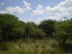
 Situated in the middle of the pampas
, the low, flat steppe
receives 500 mm of rain a year, diminishing towards the West. The low humidity
and temperate
weather result in high contrast in temperature between day and night, which is reflected in the vegetation of the region.
Summers are warm throughout the province, with warmer days in the west (about 32ºC, or 90F) than in the east (30ºC, or 86F) and cool nights, ranging from 16ºC (61F) in the north to 14ºC (57F) in the south: the thermal amplitude is thus quite remarkable. Heat waves are frequent, and temperatures reach over 40ºC (104F) sometimes. These are often followed by severe storms and much colder periods, where nights can be below 10ºC (50F).
By early March nights are already noticeably cooler, and April usually brings the first frosty nights. Averages range from 19ºC (66F) to 22ºC (72F) during the day, and 7ºC (45F) to 10ºC (50F) at night, with dryer conditions than in the summer.
Winters in La Pampa are usually dry and sunny, with cool days and quite cold nights, and some marked variations between warmer and colder periods. Daytime temperatures range from 15ºC (59F) in the north and west, to about 12ºC (54F) in the southernmost areas. Nighttime lows range from about 3ºC (37F) in the northeast corner to around 0ºC (32F) or slightly below freezing in many southern and western areas. That being said, northerly winds occasionally bring days of up to 25ºC (77F), while southern winds can keep daytime highs below 5ºC (41F). Nights below -5ºC (23F) are quite common everywhere, with temperatures below -10ºC (14F) possible in most areas.
Spring is marked by wide variations and periods of drought followed by severe thunderstorms: it is the season of hail, and it is not uncommon to see temperatures reach 35ºC (95F) on one day, and then fail to reach 15ºC (59F) two days later, with frost possible until October and perhaps later.
Overall, precipitation ranges from about 700 mm in the east/northeast, to 500 mm in the centre (agricultural frontier), and values below 400 mm in the south and west.
Northwestern La Pampa is part of the pampa húmeda
, adjacent to the Province of Buenos Aires
. The influence of the Cuyo region can be seen in the west, with a low mountain range
of 600 meters.
There are only two major rivers in the province: the Colorado
("Red River") on the border with the Province of Río Negro
, and the Salado
("Salty River") crossing it. The Salado's level has been dropping, as its tributaries
in the Province of Mendoza
are diverted for irrigation
.
Agriculture contributes a fourth to La Pampa's economy, the most important activity being cattle
ranching, with 3,632,684 (2002) head, which takes place all over the province. Other livestock
include 202,428 sheep, 140,498 goat
s and 64,118 pig
s.
 The Northeast, on the more fertile lands, has also an important activity with wheat
(10% of the national production), sunflower
(13% of NP), maize
, alfalfa
, barley
, and other cereals.
There's also a dairy
industry of 300 centres of extraction and 25 cheese
factories, honey
production, and salt extraction from salt basins.
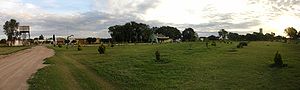
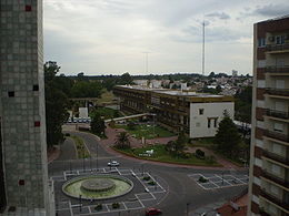
La Pampa is home to very little industry, construction or mining and, so, its services sector accounts for over two-thirds of the economy, a fairly high proportion. Tourism is an underdeveloped activity, however. Visitors start at Santa Rosa
and reach Lihué Calel National Park
, Parque Luro Provincial Reserve or visit one of the many estancias, some of which are dedicated to agritourism
.
 The province is divided in 22 departments
(Spanish: departamentos).
Department (Capital)
Provinces of Argentina
Argentina is subdivided into twenty-three provinces and one autonomous city...
of Argentina
Argentina
Argentina , officially the Argentine Republic , is the second largest country in South America by land area, after Brazil. It is constituted as a federation of 23 provinces and an autonomous city, Buenos Aires...
, located in the Pampa
Pampa
The Pampas are the fertile South American lowlands, covering more than , that include the Argentine provinces of Buenos Aires, La Pampa, Santa Fe, Entre Ríos and Córdoba, most of Uruguay, and the southernmost Brazilian State, Rio Grande do Sul...
s in the center of the country. Neighboring provinces are from the north clockwise San Luis
San Luis Province
San Luis is a province of Argentina located near the geographical center of the country . Neighboring provinces are, from the north clockwise, La Rioja, Córdoba, La Pampa, Mendoza and San Juan.-History:...
, Córdoba, Buenos Aires
Buenos Aires Province
The Province of Buenos Aires is the largest and most populous province of Argentina. It takes the name from the city of Buenos Aires, which used to be the provincial capital until it was federalized in 1880...
, Río Negro
Río Negro Province
Río Negro is a province of Argentina, located at the northern edge of Patagonia. Neighboring provinces are from the south clockwise Chubut, Neuquén, Mendoza, La Pampa and Buenos Aires. To the east lies the Atlantic Ocean.Its capital is Viedma...
, Neuquén
Neuquén Province
Neuquén is a province of Argentina, located in the west of the country, at the northern end of Patagonia. It borders Mendoza Province to the north, Rio Negro Province to the southeast, and Chile to the west...
and Mendoza
Mendoza Province
The Province of Mendoza is a province of Argentina, located in the western central part of the country in the Cuyo region. It borders to the north with San Juan, the south with La Pampa and Neuquén, the east with San Luis, and to the west with the republic of Chile; the international limit is...
.
History
Hernandarias
Hernandarias may refer to:* Hernando Arias de Saavedra, the first American-born governor in South America.* Hernandarias District, in Alto Paraná department, in Paraguay.* The Hernandarias Subfluvial Tunnel, joining Santa Fe and Paraná, in Argentina....
was the first explorer to reach the area later explored by Jerónimo Luis de Cabrera in 1662. But it was not until the 18th century that permanent settlements were installed. Resistance of the local aborigines prevented expansion until the government of Rosas
Juan Manuel de Rosas
Juan Manuel de Rosas , was an argentine militar and politician, who was elected governor of the province of Buenos Aires in 1829 to 1835, and then of the Argentine Confederation from 1835 until 1852...
, and did not cease until Julio Roca's Conquest of the desert
Conquest of the Desert
The Conquest of the Desert was a military campaign directed mainly by General Julio Argentino Roca in the 1870s, which established Argentine dominance over Patagonia, which was inhabited by indigenous peoples...
in the 19th century. The territory was divided between the officers, and the first settlements were erected.
The Territorio Nacional de La Pampa Central was created in 1884, containing the Río Negro Province
Río Negro Province
Río Negro is a province of Argentina, located at the northern edge of Patagonia. Neighboring provinces are from the south clockwise Chubut, Neuquén, Mendoza, La Pampa and Buenos Aires. To the east lies the Atlantic Ocean.Its capital is Viedma...
and parts of other surrounding provinces, and around 25.000 inhabitants. In 1915 there were already 110,000. In 1945 the territory was divided and La Pampa became a province.
In 1952 its constitution was indited and the province renamed after Eva Perón
Eva Perón
María Eva Duarte de Perón was the second wife of President Juan Perón and served as the First Lady of Argentina from 1946 until her death in 1952. She is often referred to as simply Eva Perón, or by the affectionate Spanish language diminutive Evita.She was born in the village of Los Toldos in...
. In 1955 both La Pampa and Chaco
Chaco Province
Chaco is an Argentine province located in the north of the country, near the border with Paraguay. Its capital is Resistencia on the Paraná River opposite the city of Corrientes...
, the other province renamed at the same time, this one after Juan Perón
Juan Perón
Juan Domingo Perón was an Argentine military officer, and politician. Perón was three times elected as President of Argentina though he only managed to serve one full term, after serving in several government positions, including the Secretary of Labor and the Vice Presidency...
, were renamed back to their original names.
Geography and climate
Pampa
The Pampas are the fertile South American lowlands, covering more than , that include the Argentine provinces of Buenos Aires, La Pampa, Santa Fe, Entre Ríos and Córdoba, most of Uruguay, and the southernmost Brazilian State, Rio Grande do Sul...
, the low, flat steppe
Steppe
In physical geography, steppe is an ecoregion, in the montane grasslands and shrublands and temperate grasslands, savannas, and shrublands biomes, characterized by grassland plains without trees apart from those near rivers and lakes...
receives 500 mm of rain a year, diminishing towards the West. The low humidity
Humidity
Humidity is a term for the amount of water vapor in the air, and can refer to any one of several measurements of humidity. Formally, humid air is not "moist air" but a mixture of water vapor and other constituents of air, and humidity is defined in terms of the water content of this mixture,...
and temperate
Temperate
In geography, temperate or tepid latitudes of the globe lie between the tropics and the polar circles. The changes in these regions between summer and winter are generally relatively moderate, rather than extreme hot or cold...
weather result in high contrast in temperature between day and night, which is reflected in the vegetation of the region.
Summers are warm throughout the province, with warmer days in the west (about 32ºC, or 90F) than in the east (30ºC, or 86F) and cool nights, ranging from 16ºC (61F) in the north to 14ºC (57F) in the south: the thermal amplitude is thus quite remarkable. Heat waves are frequent, and temperatures reach over 40ºC (104F) sometimes. These are often followed by severe storms and much colder periods, where nights can be below 10ºC (50F).
By early March nights are already noticeably cooler, and April usually brings the first frosty nights. Averages range from 19ºC (66F) to 22ºC (72F) during the day, and 7ºC (45F) to 10ºC (50F) at night, with dryer conditions than in the summer.
Winters in La Pampa are usually dry and sunny, with cool days and quite cold nights, and some marked variations between warmer and colder periods. Daytime temperatures range from 15ºC (59F) in the north and west, to about 12ºC (54F) in the southernmost areas. Nighttime lows range from about 3ºC (37F) in the northeast corner to around 0ºC (32F) or slightly below freezing in many southern and western areas. That being said, northerly winds occasionally bring days of up to 25ºC (77F), while southern winds can keep daytime highs below 5ºC (41F). Nights below -5ºC (23F) are quite common everywhere, with temperatures below -10ºC (14F) possible in most areas.
Spring is marked by wide variations and periods of drought followed by severe thunderstorms: it is the season of hail, and it is not uncommon to see temperatures reach 35ºC (95F) on one day, and then fail to reach 15ºC (59F) two days later, with frost possible until October and perhaps later.
Overall, precipitation ranges from about 700 mm in the east/northeast, to 500 mm in the centre (agricultural frontier), and values below 400 mm in the south and west.
Northwestern La Pampa is part of the pampa húmeda
Humid Pampa
The Humid Pampa is an extensive region of flat, fertile grassland of loessic origin in Argentina. It has a precipitation average of 900 mm per year, in contrast with the Dry Pampas to the west, which average less than 700 mm.-Setting:...
, adjacent to the Province of Buenos Aires
Buenos Aires Province
The Province of Buenos Aires is the largest and most populous province of Argentina. It takes the name from the city of Buenos Aires, which used to be the provincial capital until it was federalized in 1880...
. The influence of the Cuyo region can be seen in the west, with a low mountain range
Mountain range
A mountain range is a single, large mass consisting of a succession of mountains or narrowly spaced mountain ridges, with or without peaks, closely related in position, direction, formation, and age; a component part of a mountain system or of a mountain chain...
of 600 meters.
There are only two major rivers in the province: the Colorado
Colorado River (Argentina)
The Colorado River is a river in the south of Argentina.The Colorado river marks most of the political limit between the provinces of Neuquén and Mendoza, and between Rio Negro and La Pampa...
("Red River") on the border with the Province of Río Negro
Río Negro Province
Río Negro is a province of Argentina, located at the northern edge of Patagonia. Neighboring provinces are from the south clockwise Chubut, Neuquén, Mendoza, La Pampa and Buenos Aires. To the east lies the Atlantic Ocean.Its capital is Viedma...
, and the Salado
Salado River (Buenos Aires)
The Salado River is a river in northern Buenos Aires Province, Argentina. It originates at El Chañar Lake on the border with Santa Fe Province, above mean sea level, and flows generally southeast for before debouching into Samborombón Bay, part of the Río de la Plata estuary on the Atlantic Ocean...
("Salty River") crossing it. The Salado's level has been dropping, as its tributaries
Tributary
A tributary or affluent is a stream or river that flows into a main stem river or a lake. A tributary does not flow directly into a sea or ocean...
in the Province of Mendoza
Mendoza Province
The Province of Mendoza is a province of Argentina, located in the western central part of the country in the Cuyo region. It borders to the north with San Juan, the south with La Pampa and Neuquén, the east with San Luis, and to the west with the republic of Chile; the international limit is...
are diverted for irrigation
Irrigation
Irrigation may be defined as the science of artificial application of water to the land or soil. It is used to assist in the growing of agricultural crops, maintenance of landscapes, and revegetation of disturbed soils in dry areas and during periods of inadequate rainfall...
.
Economy
La Pampa, long Argentina's most economically agricultural province, produced an estimated US$3.2 billion in output in 2006, or, US$10,500 per capita (almost 20% above the national average).Agriculture contributes a fourth to La Pampa's economy, the most important activity being cattle
Cattle
Cattle are the most common type of large domesticated ungulates. They are a prominent modern member of the subfamily Bovinae, are the most widespread species of the genus Bos, and are most commonly classified collectively as Bos primigenius...
ranching, with 3,632,684 (2002) head, which takes place all over the province. Other livestock
Livestock
Livestock refers to one or more domesticated animals raised in an agricultural setting to produce commodities such as food, fiber and labor. The term "livestock" as used in this article does not include poultry or farmed fish; however the inclusion of these, especially poultry, within the meaning...
include 202,428 sheep, 140,498 goat
Goat
The domestic goat is a subspecies of goat domesticated from the wild goat of southwest Asia and Eastern Europe. The goat is a member of the Bovidae family and is closely related to the sheep as both are in the goat-antelope subfamily Caprinae. There are over three hundred distinct breeds of...
s and 64,118 pig
Pig
A pig is any of the animals in the genus Sus, within the Suidae family of even-toed ungulates. Pigs include the domestic pig, its ancestor the wild boar, and several other wild relatives...
s.
Wheat
Wheat is a cereal grain, originally from the Levant region of the Near East, but now cultivated worldwide. In 2007 world production of wheat was 607 million tons, making it the third most-produced cereal after maize and rice...
(10% of the national production), sunflower
Sunflower
Sunflower is an annual plant native to the Americas. It possesses a large inflorescence . The sunflower got its name from its huge, fiery blooms, whose shape and image is often used to depict the sun. The sunflower has a rough, hairy stem, broad, coarsely toothed, rough leaves and circular heads...
(13% of NP), maize
Maize
Maize known in many English-speaking countries as corn or mielie/mealie, is a grain domesticated by indigenous peoples in Mesoamerica in prehistoric times. The leafy stalk produces ears which contain seeds called kernels. Though technically a grain, maize kernels are used in cooking as a vegetable...
, alfalfa
Alfalfa
Alfalfa is a flowering plant in the pea family Fabaceae cultivated as an important forage crop in the US, Canada, Argentina, France, Australia, the Middle East, South Africa, and many other countries. It is known as lucerne in the UK, France, Australia, South Africa and New Zealand, and known as...
, barley
Barley
Barley is a major cereal grain, a member of the grass family. It serves as a major animal fodder, as a base malt for beer and certain distilled beverages, and as a component of various health foods...
, and other cereals.
There's also a dairy
Dairy
A dairy is a business enterprise established for the harvesting of animal milk—mostly from cows or goats, but also from buffalo, sheep, horses or camels —for human consumption. A dairy is typically located on a dedicated dairy farm or section of a multi-purpose farm that is concerned...
industry of 300 centres of extraction and 25 cheese
Cheese
Cheese is a generic term for a diverse group of milk-based food products. Cheese is produced throughout the world in wide-ranging flavors, textures, and forms....
factories, honey
Honey
Honey is a sweet food made by bees using nectar from flowers. The variety produced by honey bees is the one most commonly referred to and is the type of honey collected by beekeepers and consumed by humans...
production, and salt extraction from salt basins.
La Pampa is home to very little industry, construction or mining and, so, its services sector accounts for over two-thirds of the economy, a fairly high proportion. Tourism is an underdeveloped activity, however. Visitors start at Santa Rosa
Santa Rosa, Argentina
Santa Rosa is a city in the Argentine Pampas, and the capital of La Pampa Province, Argentina. It lies on the east of the province, on the shore of the Don Tomás Lagoon, at the intersection of National Routes 5 and 35. The city and its surroundings hold 102,610 inhabitants , around a third of the...
and reach Lihué Calel National Park
Lihué Calel National Park
Lihué Calel National Park is a national park in Argentina, in the Lihue Calel Department of La Pampa Province. Covering 99 square kilometres, it was established in 1977....
, Parque Luro Provincial Reserve or visit one of the many estancias, some of which are dedicated to agritourism
Agritourism
Agritourism, as it is defined most broadly, involves any agriculturally-based operation or activity that brings visitors to a farm or ranch. Agritourism has different definitions in different parts of the world, and sometimes refers specifically to farm stays, as in Italy...
.
Political division
Departments of Argentina
Departments form the second level of administrative division in the provinces of Argentina. There are no departments in the city of Buenos Aires, which has so far been divided into neighbourhoods as its administrative divisions, but is to be divided now into communes by a recently passed local act...
(Spanish: departamentos).
Department (Capital)
- Atreuco Department (MacachínMacachínMacachín is a town in La Pampa Province in Argentina.-References:...
) - Caleu Caleu DepartmentCaleu Caleu DepartmentCaleu Caleu Department is a department in southeastern La Pampa Province, Argentina. The name means gull in the Mapuche language. To the north it borders Hucal Department, to the east Buenos Aires Province, to the south Río Negro Province, and to the west Lihuel Cahel Department.Many of the borders...
(La AdelaLa AdelaLa Adela is a village and rural locality in La Pampa Province in Argentina.-References:...
) - Capital (Santa RosaSanta Rosa, ArgentinaSanta Rosa is a city in the Argentine Pampas, and the capital of La Pampa Province, Argentina. It lies on the east of the province, on the shore of the Don Tomás Lagoon, at the intersection of National Routes 5 and 35. The city and its surroundings hold 102,610 inhabitants , around a third of the...
) - Catriló Department (CatrilóCatrilóCatriló is a town in La Pampa Province in Argentina.-References:...
) - Chalileo Department (Santa Isabel)
- Chapaleufú Department (Intendente AlvearIntendente AlvearIntendente Alvear is a town in La Pampa Province in Argentina.-References:...
) - Chical Có Department (Algarrobo del AguilaAlgarrobo del ÁguilaAlgarrobo del Águila is a village and rural locality in La Pampa Province in Argentina.-References:...
) - Conhelo Department (Eduardo CastexEduardo CastexEduardo Castex is a small city, capital of Conhelo, in La Pampa Province, Argentina.The city is a centre of agricultural activity and the main producer of wheat in La Pampa. Its name comes from the founder Ingeniero Eduardo Castex, in the first years of the 20th century...
) - Curacó Department (PuelchesPuelchesPuelches is a village and rural locality in La Pampa Province in Argentina.-References:...
) - Guatraché Department (GuatrachéGuatrachéGuatraché is a town in La Pampa Province in Argentina.-History:Guatraché was officially founded on 19 April 1908 though a settlement already existed previously. The town was settled to the east of the actual settlement, in front of the old railroad station, and due to subsequent floods the town...
) - Huncal Department (Bernasconi)
- Lihué Calel Department (Cuchillo-CoCuchillo-CóCuchillo-Có is a village and rural locality in La Pampa Province in Argentina.-References:...
) - Limay Mahuida Department (Limay MahuidaLimay MahuidaLimay Mahuida is a village and rural locality in La Pampa Province in Argentina.-References:...
) - Loventué Department (Victorica)
- Maracó Department (General PicoGeneral PicoGeneral Pico is a city located in the north-east of La Pampa Province, Argentina. It has a surface of . Is located at above sea level and inside the region of the Pampa Húmeda Llana...
) - Puelén Department (Veinticinco de Mayo)
- Quemú Quemú Department (Quemú QuemúQuemú QuemúQuemú Quemú is a town in La Pampa Province in Argentina.-References:...
) - Rancul Department (PareraPareraParera is a town in La Pampa Province in Argentina....
) - Realicó Department (RealicóRealicóRealicó is a city in the province of La Pampa, Argentina. It was founded the second of March in 1907 by Tomás Leopoldo Mullally. The small farming town has a population of about 9,000. There is one stoplight, and it is always blinking...
) - Toay Department (ToayToayToay is a town in La Pampa Province in Argentina.-References:...
) - Trenel Department (TrenelTrenelTrenel is a town in La Pampa Province in Argentina.-References:...
) - Utracán Department (General AchaGeneral AchaGeneral Acha is a town in La Pampa Province in Argentina.-References:...
)
External links
- Official (government) Website (Spanish)
- Provincial Tourist Office (Spanish)
- Universidad Nacional de La Pampa (Spanish)
- REGION Guide to La Pampa (Spanish/English)
- Map of La Pampa and its Departamentos (out of date)