
Longitude
Encyclopedia
Longitude is a geographic coordinate that specifies the east-west position of a point on the Earth's surface. It is an angular measurement, usually expressed in degrees, minutes and seconds
, and denoted by the Greek letter
lambda
(λ).
Points with the same longitude lie in lines running from the North Pole to the South Pole. By convention, one of these, the Prime Meridian
, which passes through the Royal Observatory, Greenwich
, England, establishes the position of zero degrees longitude. The longitude of other places is measured as an angle east or west from the Prime Meridian. Specifically, it is the angle between a plane containing the Prime Meridian and a plane containing the North Pole, South Pole and the location in question. If the direction of longitude (east or west) is not specified, positive longitude values are east of the Prime Meridian, and negative values are west of the Prime Meridian. This forms a right-handed coordinate system with the z axis (right hand thumb) pointing from the Earth's center toward the North Pole and the x axis (right hand index finger) extending from Earth's center through the equator at the Prime Meridian.
A location's north-south position along a meridian is given by its latitude
, which is the angle between the local vertical and the plane of the Equator.
If the Earth were perfectly symmetrical and homogenous, then longitude at a point would just be the angle between a vertical north-south plane through that point and the plane of the Greenwich meridian. Everywhere on Earth the vertical north-south plane would contain the Earth's axis.
But the Earth is not homogenous, and has mountains-- which have gravity and so can shift the vertical plane away from the Earth's axis. The vertical north-south plane still intersects the plane of the Greenwich meridian at some angle; that angle is astronomical longitude, the longitude you calculate from star observations. The longitude shown on maps and GPS devices is the angle between the Greenwich plane and a not-quite-vertical plane through the point; the not-quite-vertical plane is perpendicular to the surface of the spheroid chosen to approximate the Earth's sea-level surface, rather than perpendicular to the sea-level surface itself.
 The measurement of longitude is important both to cartography
and to provide safe ocean navigation
. Mariners and explorers for most of history struggled to determine precise longitude. Finding a method of determining exact longitude took centuries, resulting in the history of longitude
recording the effort of some of the greatest scientific minds.
Latitude was calculated by observing with quadrant
or astrolabe
the inclination of the sun or of charted stars, but longitude presented no such manifest means of study. Amerigo Vespucci
was perhaps the first to proffer a solution, after devoting a great deal of time and energy studying the problem during his sojourns in the New World
:
By comparing the relative positions of the moon and Mars with their anticipated positions, Vespucci was able to crudely deduce his longitude. But this method had several limitations: First, it required the occurrence of a specific astronomical event (in this case, Mars passing through the same right ascension
as the moon), and the observer needed to anticipate this event via an astronomical almanac
. One needed also to know the precise time, which was difficult to ascertain in foreign lands. Finally, it required a stable viewing platform, rendering the technique useless on the rolling deck of a ship at sea. See Lunar distance (navigation)
.
In 1612, Galileo Galilei
proposed that with sufficiently accurate knowledge of the orbits of the moons of Jupiter one could use their positions as a universal clock and this would make possible the determination of longitude, but the practical problems of the method he devised were severe and it was never used at sea. In the early 1700s there were several maritime disasters attributable to serious errors in reckoning position at sea, such as the loss of four ships of the fleet of Sir Cloudesley Shovell
in the Scilly naval disaster of 1707
. Motivated by these disasters, in 1714 the British government established the Board of Longitude
: prizes were to be awarded to the first person to demonstrate a practical method for determining the longitude of a ship at sea. These prizes motivated many to search for a solution.
John Harrison
, a self-educated English
clockmaker
then invented the marine chronometer
, a key piece in solving the problem of accurately establishing longitude at sea, thus revolutionising and extending the possibility of safe long distance sea travel. Though the British rewarded John Harrison for his marine chronometer in 1773, chronometers remained very expensive and the lunar distance method continued to be used for decades. Finally, the combination of the availability of marine chronometers and wireless telegraph time signals put an end to the use of lunars in the 20th century.
Unlike latitude, which has the equator as a natural starting position, there is no natural starting position for longitude. Therefore, a reference meridian had to be chosen. It was a popular practice to use a nation's capital as the starting point, but other significant locations were also used. While British
cartographers had long used the Greenwich meridian in London, other references were used elsewhere, including: El Hierro
, Rome
, Copenhagen
, Jerusalem, Saint Petersburg
, Pisa
, Paris
, Philadelphia
, and Washington. In 1884, the International Meridian Conference
adopted the Greenwich meridian as the universal Prime Meridian or zero point of longitude.
ranging from 0° at the Prime Meridian to +180° eastward and −180° westward. The Greek letter λ (lambda), is used to denote the location of a place on Earth east or west of the Prime Meridian.
Each degree of longitude is sub-divided into 60 minutes
, each of which is divided into 60 seconds. A longitude is thus specified in sexagesimal notation as 23° 27′ 30" E. For higher precision, the seconds are specified with a decimal fraction. An alternative representation uses degrees and minutes, where parts of a minute are expressed in decimal notation with a fraction, thus: 23° 27.500′ E. Degrees may also be expressed as a decimal fraction: 23.45833° E. For calculations, the angular measure may be converted to radian
s, so longitude may also be expressed in this manner as a signed fraction of π (pi
), or an unsigned fraction of 2π.
For calculations, the West/East suffix is replaced by a negative sign in the western hemisphere
. Confusingly, the convention of negative for East is also sometimes seen. The preferred convention—that East be positive—is consistent with a right-handed Cartesian coordinate system
, with the North Pole up. A specific longitude may then be combined with a specific latitude (usually positive in the northern hemisphere
) to give a precise position on the Earth's surface.
Longitude at a point may be determined by calculating the time difference between that at its location and Coordinated Universal Time
(UTC). Since there are 24 hours in a day and 360 degrees in a circle, the sun moves across the sky at a rate of 15 degrees per hour (360°/24 hours = 15° per hour). So if the time zone
a person is in is three hours ahead of UTC then that person is near 45° longitude (3 hours × 15° per hour = 45°). The word near was used because the point might not be at the center of the time zone; also the time zones are defined politically, so their centers and boundaries often do not lie on meridians at multiples of 15°. In order to perform this calculation, however, a person needs to have a chronometer
(watch) set to UTC and needs to determine local time by solar or astronomical observation. The details are more complex than described here: see the articles on Universal Time
and on the equation of time
for more details.
at the Poles
and calculations that are sufficiently accurate for other positions, may be inaccurate at or near the Poles. Also the discontinuity at the ±180° meridian
must be handled with care in calculations. An example is a calculation of east displacement by subtracting two longitudes, which gives wrong answer if the two positions are on either side of this meridian. To avoid these complexities, consider replacing latitude and longitude with another horizontal position representation
in calculation.
The surface layer of the Earth, the lithosphere
, is broken up into several tectonic plates
. Each plate moves in a different direction, at speeds of about 50 to 100 mm per year. As a result, for example, the longitudinal difference between a point on the Equator in Uganda (on the African Plate
) and a point on the Equator in Ecuador (on the South American Plate
) is increasing by about 0.0014 arcseconds per year.
If a global reference frame such as WGS84 is used, the longitude of a place on the surface will change from year to year. To minimize this change, when dealing exclusively with points on a single plate, a different reference frame can be used, whose coordinates are fixed to a particular plate, such as NAD83 for North America or ETRS89 for Europe.
s, both the radius and the length of arc varies with latitude. This variation requires the introduction of elliptic parameters based on an ellipse's angular eccentricity
, which equals
  , where
  and
and  are the equatorial and polar radii;
  is the first eccentricity
squared, ; and
; and  or
or  is the flattening
, . Utilized in creating the integrands for curvature
is the inverse of the principal elliptic integrand, :
:
Degree (angle)
A degree , usually denoted by ° , is a measurement of plane angle, representing 1⁄360 of a full rotation; one degree is equivalent to π/180 radians...
, and denoted by the Greek letter
Greek alphabet
The Greek alphabet is the script that has been used to write the Greek language since at least 730 BC . The alphabet in its classical and modern form consists of 24 letters ordered in sequence from alpha to omega...
lambda
Lambda
Lambda is the 11th letter of the Greek alphabet. In the system of Greek numerals lambda has a value of 30. Lambda is related to the Phoenician letter Lamed . Letters in other alphabets that stemmed from lambda include the Roman L and the Cyrillic letter El...
(λ).
Points with the same longitude lie in lines running from the North Pole to the South Pole. By convention, one of these, the Prime Meridian
Prime Meridian
The Prime Meridian is the meridian at which the longitude is defined to be 0°.The Prime Meridian and its opposite the 180th meridian , which the International Date Line generally follows, form a great circle that divides the Earth into the Eastern and Western Hemispheres.An international...
, which passes through the Royal Observatory, Greenwich
Royal Observatory, Greenwich
The Royal Observatory, Greenwich , in London, England played a major role in the history of astronomy and navigation, and is best known as the location of the prime meridian...
, England, establishes the position of zero degrees longitude. The longitude of other places is measured as an angle east or west from the Prime Meridian. Specifically, it is the angle between a plane containing the Prime Meridian and a plane containing the North Pole, South Pole and the location in question. If the direction of longitude (east or west) is not specified, positive longitude values are east of the Prime Meridian, and negative values are west of the Prime Meridian. This forms a right-handed coordinate system with the z axis (right hand thumb) pointing from the Earth's center toward the North Pole and the x axis (right hand index finger) extending from Earth's center through the equator at the Prime Meridian.
A location's north-south position along a meridian is given by its latitude
Latitude
In geography, the latitude of a location on the Earth is the angular distance of that location south or north of the Equator. The latitude is an angle, and is usually measured in degrees . The equator has a latitude of 0°, the North pole has a latitude of 90° north , and the South pole has a...
, which is the angle between the local vertical and the plane of the Equator.
If the Earth were perfectly symmetrical and homogenous, then longitude at a point would just be the angle between a vertical north-south plane through that point and the plane of the Greenwich meridian. Everywhere on Earth the vertical north-south plane would contain the Earth's axis.
But the Earth is not homogenous, and has mountains-- which have gravity and so can shift the vertical plane away from the Earth's axis. The vertical north-south plane still intersects the plane of the Greenwich meridian at some angle; that angle is astronomical longitude, the longitude you calculate from star observations. The longitude shown on maps and GPS devices is the angle between the Greenwich plane and a not-quite-vertical plane through the point; the not-quite-vertical plane is perpendicular to the surface of the spheroid chosen to approximate the Earth's sea-level surface, rather than perpendicular to the sea-level surface itself.
History
Cartography
Cartography is the study and practice of making maps. Combining science, aesthetics, and technique, cartography builds on the premise that reality can be modeled in ways that communicate spatial information effectively.The fundamental problems of traditional cartography are to:*Set the map's...
and to provide safe ocean navigation
Navigation
Navigation is the process of monitoring and controlling the movement of a craft or vehicle from one place to another. It is also the term of art used for the specialized knowledge used by navigators to perform navigation tasks...
. Mariners and explorers for most of history struggled to determine precise longitude. Finding a method of determining exact longitude took centuries, resulting in the history of longitude
History of longitude
The history of longitude is a record of the effort, by navigators and scientists over several centuries, to discover a means of determining longitude....
recording the effort of some of the greatest scientific minds.
Latitude was calculated by observing with quadrant
Quadrant (instrument)
A quadrant is an instrument that is used to measure angles up to 90°. It was originally proposed by Ptolemy as a better kind of astrolabe. Several different variations of the instrument were later produced by medieval Muslim astronomers.-Types of quadrants:...
or astrolabe
Astrolabe
An astrolabe is an elaborate inclinometer, historically used by astronomers, navigators, and astrologers. Its many uses include locating and predicting the positions of the Sun, Moon, planets, and stars, determining local time given local latitude and longitude, surveying, triangulation, and to...
the inclination of the sun or of charted stars, but longitude presented no such manifest means of study. Amerigo Vespucci
Amerigo Vespucci
Amerigo Vespucci was an Italian explorer, financier, navigator and cartographer. The Americas are generally believed to have derived their name from the feminized Latin version of his first name.-Expeditions:...
was perhaps the first to proffer a solution, after devoting a great deal of time and energy studying the problem during his sojourns in the New World
New World
The New World is one of the names used for the Western Hemisphere, specifically America and sometimes Oceania . The term originated in the late 15th century, when America had been recently discovered by European explorers, expanding the geographical horizon of the people of the European middle...
:
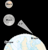
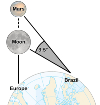
As to longitude, I declare that I found so much difficulty in determining it that I was put to great pains to ascertain the east-west distance I had covered. The final result of my labours was that I found nothing better to do than to watch for and take observations at night of the conjunction of one planet with another, and especially of the conjunction of the moon with the other planets, because the moon is swifter in her course than any other planet. I compared my observations with an almanac. After I had made experiments many nights, one night, the twenty-third of August, 1499, there was a conjunction of the moon with Mars, which according to the almanac was to occur at midnight or a half hour before. I found that...at midnight Mars's position was three and a half degrees to the east.
By comparing the relative positions of the moon and Mars with their anticipated positions, Vespucci was able to crudely deduce his longitude. But this method had several limitations: First, it required the occurrence of a specific astronomical event (in this case, Mars passing through the same right ascension
Right ascension
Right ascension is the astronomical term for one of the two coordinates of a point on the celestial sphere when using the equatorial coordinate system. The other coordinate is the declination.-Explanation:...
as the moon), and the observer needed to anticipate this event via an astronomical almanac
Almanac
An almanac is an annual publication that includes information such as weather forecasts, farmers' planting dates, and tide tables, containing tabular information in a particular field or fields often arranged according to the calendar etc...
. One needed also to know the precise time, which was difficult to ascertain in foreign lands. Finally, it required a stable viewing platform, rendering the technique useless on the rolling deck of a ship at sea. See Lunar distance (navigation)
Lunar distance (navigation)
In celestial navigation, lunar distance is the angle between the Moon and another celestial body. A navigator can use a lunar distance and a nautical almanac to calculate Greenwich time...
.
In 1612, Galileo Galilei
Galileo Galilei
Galileo Galilei , was an Italian physicist, mathematician, astronomer, and philosopher who played a major role in the Scientific Revolution. His achievements include improvements to the telescope and consequent astronomical observations and support for Copernicanism...
proposed that with sufficiently accurate knowledge of the orbits of the moons of Jupiter one could use their positions as a universal clock and this would make possible the determination of longitude, but the practical problems of the method he devised were severe and it was never used at sea. In the early 1700s there were several maritime disasters attributable to serious errors in reckoning position at sea, such as the loss of four ships of the fleet of Sir Cloudesley Shovell
Cloudesley Shovell
Admiral of the Fleet Sir Cloudesley Shovell , was an English naval officer. Rising through the ranks and fighting in many of the important battles of the late 17th and early 18th centuries, he became a popular British hero, whose celebrated career was brought to an end in a disastrous shipwreck in...
in the Scilly naval disaster of 1707
Scilly naval disaster of 1707
Scilly naval disaster of 1707 is an umbrella term for the events of 22 October 1707 that led to the sinking of a British naval fleet off the Isles of Scilly. With four large ships and more than 1,400 sailors lost in stormy weather, it was one of the greatest maritime disasters in the history of...
. Motivated by these disasters, in 1714 the British government established the Board of Longitude
Board of Longitude
The Board of Longitude was the popular name for the Commissioners for the Discovery of the Longitude at Sea. It was a British Government body formed in 1714 to administer a scheme of prizes intended to encourage innovators to solve the problem of finding longitude at sea.-Origins:Navigators and...
: prizes were to be awarded to the first person to demonstrate a practical method for determining the longitude of a ship at sea. These prizes motivated many to search for a solution.
John Harrison
John Harrison
John Harrison was a self-educated English clockmaker. He invented the marine chronometer, a long-sought device in solving the problem of establishing the East-West position or longitude of a ship at sea, thus revolutionising and extending the possibility of safe long distance sea travel in the Age...
, a self-educated English
England
England is a country that is part of the United Kingdom. It shares land borders with Scotland to the north and Wales to the west; the Irish Sea is to the north west, the Celtic Sea to the south west, with the North Sea to the east and the English Channel to the south separating it from continental...
clockmaker
Clockmaker
A clockmaker is an artisan who makes and repairs clocks. Since almost all clocks are now factory-made, most modern clockmakers only repair clocks. Modern clockmakers may be employed by jewellers, antique shops, and places devoted strictly to repairing clocks and watches...
then invented the marine chronometer
Marine chronometer
A marine chronometer is a clock that is precise and accurate enough to be used as a portable time standard; it can therefore be used to determine longitude by means of celestial navigation...
, a key piece in solving the problem of accurately establishing longitude at sea, thus revolutionising and extending the possibility of safe long distance sea travel. Though the British rewarded John Harrison for his marine chronometer in 1773, chronometers remained very expensive and the lunar distance method continued to be used for decades. Finally, the combination of the availability of marine chronometers and wireless telegraph time signals put an end to the use of lunars in the 20th century.
Unlike latitude, which has the equator as a natural starting position, there is no natural starting position for longitude. Therefore, a reference meridian had to be chosen. It was a popular practice to use a nation's capital as the starting point, but other significant locations were also used. While British
Great Britain
Great Britain or Britain is an island situated to the northwest of Continental Europe. It is the ninth largest island in the world, and the largest European island, as well as the largest of the British Isles...
cartographers had long used the Greenwich meridian in London, other references were used elsewhere, including: El Hierro
El Hierro
El Hierro, nicknamed Isla del Meridiano , is the smallest and farthest south and west of the Canary Islands , in the Atlantic Ocean off the coast of Africa, with a population of 10,162 .- Name :The name El Hierro, although phonetically identical to the Spanish word for 'iron', is generally thought...
, Rome
Rome
Rome is the capital of Italy and the country's largest and most populated city and comune, with over 2.7 million residents in . The city is located in the central-western portion of the Italian Peninsula, on the Tiber River within the Lazio region of Italy.Rome's history spans two and a half...
, Copenhagen
Copenhagen
Copenhagen is the capital and largest city of Denmark, with an urban population of 1,199,224 and a metropolitan population of 1,930,260 . With the completion of the transnational Øresund Bridge in 2000, Copenhagen has become the centre of the increasingly integrating Øresund Region...
, Jerusalem, Saint Petersburg
Saint Petersburg
Saint Petersburg is a city and a federal subject of Russia located on the Neva River at the head of the Gulf of Finland on the Baltic Sea...
, Pisa
Pisa
Pisa is a city in Tuscany, Central Italy, on the right bank of the mouth of the River Arno on the Tyrrhenian Sea. It is the capital city of the Province of Pisa...
, Paris
Paris
Paris is the capital and largest city in France, situated on the river Seine, in northern France, at the heart of the Île-de-France region...
, Philadelphia
Philadelphia, Pennsylvania
Philadelphia is the largest city in the Commonwealth of Pennsylvania and the county seat of Philadelphia County, with which it is coterminous. The city is located in the Northeastern United States along the Delaware and Schuylkill rivers. It is the fifth-most-populous city in the United States,...
, and Washington. In 1884, the International Meridian Conference
International Meridian Conference
The International Meridian Conference was a conference held in October 1884 in Washington, D.C., in the United States to determine the Prime Meridian of the world. The conference was held at the request of U.S. President Chester A...
adopted the Greenwich meridian as the universal Prime Meridian or zero point of longitude.
Noting and calculating longitude
Longitude is given as an angular measurementAngle
In geometry, an angle is the figure formed by two rays sharing a common endpoint, called the vertex of the angle.Angles are usually presumed to be in a Euclidean plane with the circle taken for standard with regard to direction. In fact, an angle is frequently viewed as a measure of an circular arc...
ranging from 0° at the Prime Meridian to +180° eastward and −180° westward. The Greek letter λ (lambda), is used to denote the location of a place on Earth east or west of the Prime Meridian.
Each degree of longitude is sub-divided into 60 minutes
Minute of arc
A minute of arc, arcminute, or minute of angle , is a unit of angular measurement equal to one sixtieth of one degree. In turn, a second of arc or arcsecond is one sixtieth of one minute of arc....
, each of which is divided into 60 seconds. A longitude is thus specified in sexagesimal notation as 23° 27′ 30" E. For higher precision, the seconds are specified with a decimal fraction. An alternative representation uses degrees and minutes, where parts of a minute are expressed in decimal notation with a fraction, thus: 23° 27.500′ E. Degrees may also be expressed as a decimal fraction: 23.45833° E. For calculations, the angular measure may be converted to radian
Radian
Radian is the ratio between the length of an arc and its radius. The radian is the standard unit of angular measure, used in many areas of mathematics. The unit was formerly a SI supplementary unit, but this category was abolished in 1995 and the radian is now considered a SI derived unit...
s, so longitude may also be expressed in this manner as a signed fraction of π (pi
Pi
' is a mathematical constant that is the ratio of any circle's circumference to its diameter. is approximately equal to 3.14. Many formulae in mathematics, science, and engineering involve , which makes it one of the most important mathematical constants...
), or an unsigned fraction of 2π.
For calculations, the West/East suffix is replaced by a negative sign in the western hemisphere
Western Hemisphere
The Western Hemisphere or western hemisphere is mainly used as a geographical term for the half of the Earth that lies west of the Prime Meridian and east of the Antimeridian , the other half being called the Eastern Hemisphere.In this sense, the western hemisphere consists of the western portions...
. Confusingly, the convention of negative for East is also sometimes seen. The preferred convention—that East be positive—is consistent with a right-handed Cartesian coordinate system
Cartesian coordinate system
A Cartesian coordinate system specifies each point uniquely in a plane by a pair of numerical coordinates, which are the signed distances from the point to two fixed perpendicular directed lines, measured in the same unit of length...
, with the North Pole up. A specific longitude may then be combined with a specific latitude (usually positive in the northern hemisphere
Northern Hemisphere
The Northern Hemisphere is the half of a planet that is north of its equator—the word hemisphere literally means “half sphere”. It is also that half of the celestial sphere north of the celestial equator...
) to give a precise position on the Earth's surface.
Longitude at a point may be determined by calculating the time difference between that at its location and Coordinated Universal Time
Coordinated Universal Time
Coordinated Universal Time is the primary time standard by which the world regulates clocks and time. It is one of several closely related successors to Greenwich Mean Time. Computer servers, online services and other entities that rely on having a universally accepted time use UTC for that purpose...
(UTC). Since there are 24 hours in a day and 360 degrees in a circle, the sun moves across the sky at a rate of 15 degrees per hour (360°/24 hours = 15° per hour). So if the time zone
Time zone
A time zone is a region on Earth that has a uniform standard time for legal, commercial, and social purposes. In order for the same clock time to always correspond to the same portion of the day as the Earth rotates , different places on the Earth need to have different clock times...
a person is in is three hours ahead of UTC then that person is near 45° longitude (3 hours × 15° per hour = 45°). The word near was used because the point might not be at the center of the time zone; also the time zones are defined politically, so their centers and boundaries often do not lie on meridians at multiples of 15°. In order to perform this calculation, however, a person needs to have a chronometer
Marine chronometer
A marine chronometer is a clock that is precise and accurate enough to be used as a portable time standard; it can therefore be used to determine longitude by means of celestial navigation...
(watch) set to UTC and needs to determine local time by solar or astronomical observation. The details are more complex than described here: see the articles on Universal Time
Universal Time
Universal Time is a time scale based on the rotation of the Earth. It is a modern continuation of Greenwich Mean Time , i.e., the mean solar time on the Prime Meridian at Greenwich, and GMT is sometimes used loosely as a synonym for UTC...
and on the equation of time
Equation of time
The equation of time is the difference between apparent solar time and mean solar time. At any given instant, this difference will be the same for every observer...
for more details.
Singularity and discontinuity of longitude
Note that the longitude is singularMathematical singularity
In mathematics, a singularity is in general a point at which a given mathematical object is not defined, or a point of an exceptional set where it fails to be well-behaved in some particular way, such as differentiability...
at the Poles
Geographical pole
A geographical pole is either of the two points—the north pole and the south pole—on the surface of a rotating planet where the axis of rotation meets the surface of the body...
and calculations that are sufficiently accurate for other positions, may be inaccurate at or near the Poles. Also the discontinuity at the ±180° meridian
180th meridian
The 180th meridian or antimeridian is the meridian which is 180° east or west of the Prime Meridian passing through the Royal Observatory, Greenwich. It is common to both east longitude and west longitude. It is used as the basis for the International Date Line because it for the most part passes...
must be handled with care in calculations. An example is a calculation of east displacement by subtracting two longitudes, which gives wrong answer if the two positions are on either side of this meridian. To avoid these complexities, consider replacing latitude and longitude with another horizontal position representation
Horizontal position representation
A position representation is the parameters used to express a position relative to a reference. Representing position in three dimensions is often done by a Euclidean vector. However, when representing position relative to the Earth it is often more convenient to represent vertical position as...
in calculation.
Plate movement and longitude
The surface layer of the Earth, the lithosphere
Lithosphere
The lithosphere is the rigid outermost shell of a rocky planet. On Earth, it comprises the crust and the portion of the upper mantle that behaves elastically on time scales of thousands of years or greater.- Earth's lithosphere :...
, is broken up into several tectonic plates
Plate tectonics
Plate tectonics is a scientific theory that describes the large scale motions of Earth's lithosphere...
. Each plate moves in a different direction, at speeds of about 50 to 100 mm per year. As a result, for example, the longitudinal difference between a point on the Equator in Uganda (on the African Plate
African Plate
The African Plate is a tectonic plate which includes the continent of Africa, as well as oceanic crust which lies between the continent and various surrounding ocean ridges.-Boundaries:...
) and a point on the Equator in Ecuador (on the South American Plate
South American Plate
The South American Plate is a continental tectonic plate which includes the continent of South America and also a sizeable region of the Atlantic Ocean seabed extending eastward to the Mid-Atlantic Ridge....
) is increasing by about 0.0014 arcseconds per year.
If a global reference frame such as WGS84 is used, the longitude of a place on the surface will change from year to year. To minimize this change, when dealing exclusively with points on a single plate, a different reference frame can be used, whose coordinates are fixed to a particular plate, such as NAD83 for North America or ETRS89 for Europe.
Elliptic parameters
Because most planets (including Earth) are closer to ellipsoids of revolution, or spheroids, rather than to sphereSphere
A sphere is a perfectly round geometrical object in three-dimensional space, such as the shape of a round ball. Like a circle in two dimensions, a perfect sphere is completely symmetrical around its center, with all points on the surface lying the same distance r from the center point...
s, both the radius and the length of arc varies with latitude. This variation requires the introduction of elliptic parameters based on an ellipse's angular eccentricity
Angular eccentricity
In the study of ellipses and related geometry, various parameters in the distortion of a circle into an ellipse are identified and employed: Aspect ratio, flattening and eccentricity....
,
which equals , where and are the equatorial and polar radii; is the first eccentricityEccentricity (mathematics)
In mathematics, the eccentricity, denoted e or \varepsilon, is a parameter associated with every conic section. It can be thought of as a measure of how much the conic section deviates from being circular.In particular,...
squared,
; and or is the flatteningFlattening
The flattening, ellipticity, or oblateness of an oblate spheroid is a measure of the "squashing" of the spheroid's pole, towards its equator...
,
. Utilized in creating the integrands for curvatureCurvature
In mathematics, curvature refers to any of a number of loosely related concepts in different areas of geometry. Intuitively, curvature is the amount by which a geometric object deviates from being flat, or straight in the case of a line, but this is defined in different ways depending on the context...
is the inverse of the principal elliptic integrand,
:-


Degree length
If the earth were spherical then a degree of latitude anywhere would cover exactly 60 north-south nautical miles, and a degree of longitude along the equator would be the same. The length of a degree of longitude (measured along a parallel of latitude) would just be 60 nautical miles times the cosine of the latitude. Since the earth isn't actually spherical the calculation is a bit more complicated.
Measured along a parallel of latitude on the spheroid, the length of a longitudinal degree at latitude is
is
where Earth's equatorial radius is and
and  ; for the GRS80 and WGS84 spheroids,
  is 6378137 meters and b/a calculates to be 0.99664719. (
 is known as the parametric or reduced latitude).
Aside from rounding this is the exact distance along a parallel of latitude on the spheroid; getting the distance along the shortest route will be more work, but those two distances are always within 0.6 meter of each other if the two points are one degree of longitude apart.
Latitude N-S radius
of curvature

Surface distance
per 1° change
in latitudeE-W radius
of curvature
Surface distance
per 1° change
in longitude0° 6335.44 km 110.574 km 6378.14 km 111.320 km 15° 6339.70 km 110.649 km 6379.57 km 107.551 km 30° 6351.38 km 110.852 km 6383.48 km 96.486 km 45° 6367.38 km 111.132 km 6388.84 km 78.847 km 60° 6383.45 km 111.412 km 6394.21 km 55.800 km 75° 6395.26 km 111.618 km 6398.15 km 28.902 km 90° 6399.59 km 111.694 km 6399.59 km 0.00
Ecliptic latitude and longitude
EclipticEclipticThe ecliptic is the plane of the earth's orbit around the sun. In more accurate terms, it is the intersection of the celestial sphere with the ecliptic plane, which is the geometric plane containing the mean orbit of the Earth around the Sun...
latitude and longitude are defined for the planets, stars, and other celestial bodies in a broadly similar way to that in which terrestrial latitude and longitude are defined, but there is a special difference.
The plane of zero latitude for celestial objects is the plane of the ecliptic and is not parallel to the plane of the celestial and terrestrial equator. This is inclined to the Equator by the obliquity of the ecliptic, which currently has a value of about 23° 26'. The closest celestial counterpart to terrestrial latitude is declinationDeclinationIn astronomy, declination is one of the two coordinates of the equatorial coordinate system, the other being either right ascension or hour angle. Declination in astronomy is comparable to geographic latitude, but projected onto the celestial sphere. Declination is measured in degrees north and...
, and the closest celestial counterpart to terrestrial longitude is right ascensionRight ascensionRight ascension is the astronomical term for one of the two coordinates of a point on the celestial sphere when using the equatorial coordinate system. The other coordinate is the declination.-Explanation:...
. These celestial coordinates bear the same relationship to the celestial equator as terrestrial latitude and longitude do to the terrestrial equator, and they are also more frequently used in astronomy than celestial longitude and latitude.
The polar axis (relative to the celestial equator) is perpendicular to the plane of the Equator, and parallel to the terrestrial polar axis. But the (north) pole of the ecliptic, relevant to the definition of ecliptic latitude, is the normal to the eclipticEclipticThe ecliptic is the plane of the earth's orbit around the sun. In more accurate terms, it is the intersection of the celestial sphere with the ecliptic plane, which is the geometric plane containing the mean orbit of the Earth around the Sun...
plane nearest to the direction of the celestial north pole of the Equator, i.e. 23° 26' away from it.
Ecliptic latitude is measured from 0° to 90° north (+) or south (−) of the ecliptic. Ecliptic longitude is measured from 0° to 360° eastward (the direction that the Sun appears to move relative to the stars), along the ecliptic from the vernal equinox. The equinox at a specific date and time is a fixed equinox, such as that in the J2000 reference frame.
However, the equinox moves because it is the intersection of two planes, both of which move. The ecliptic is relatively stationary, wobbling within a 4° diameter circle relative to the fixed stars over millions of years under the gravitational influence of the other planets. The greatest movement is a relatively rapid gyration of Earth's equatorial plane whose pole traces a 47° diameter circle caused by the Moon. This causes the equinox to precess westward along the ecliptic about 50" per year. This moving equinox is called the equinox of date. Ecliptic longitude relative to a moving equinox is used whenever the positions of the Sun, Moon, planets, or stars at dates other than that of a fixed equinox is important, as in calendarCalendarA calendar is a system of organizing days for social, religious, commercial, or administrative purposes. This is done by giving names to periods of time, typically days, weeks, months, and years. The name given to each day is known as a date. Periods in a calendar are usually, though not...
s, astrologyAstrologyAstrology consists of a number of belief systems which hold that there is a relationship between astronomical phenomena and events in the human world...
, or celestial mechanicsCelestial mechanicsCelestial mechanics is the branch of astronomy that deals with the motions of celestial objects. The field applies principles of physics, historically classical mechanics, to astronomical objects such as stars and planets to produce ephemeris data. Orbital mechanics is a subfield which focuses on...
. The 'error' of the JulianJulian calendarThe Julian calendar began in 45 BC as a reform of the Roman calendar by Julius Caesar. It was chosen after consultation with the astronomer Sosigenes of Alexandria and was probably designed to approximate the tropical year .The Julian calendar has a regular year of 365 days divided into 12 months...
or Gregorian calendarGregorian calendarThe Gregorian calendar, also known as the Western calendar, or Christian calendar, is the internationally accepted civil calendar. It was introduced by Pope Gregory XIII, after whom the calendar was named, by a decree signed on 24 February 1582, a papal bull known by its opening words Inter...
is always relative to a moving equinox. The years, months, and days of the Chinese calendarChinese calendarThe Chinese calendar is a lunisolar calendar, incorporating elements of a lunar calendar with those of a solar calendar. It is not exclusive to China, but followed by many other Asian cultures as well...
all depend on the ecliptic longitudes of date of the Sun and Moon. The 30° zodiacal segments used in astrology are also relative to a moving equinox. Celestial mechanics (here restricted to the motion of solar systemSolar SystemThe Solar System consists of the Sun and the astronomical objects gravitationally bound in orbit around it, all of which formed from the collapse of a giant molecular cloud approximately 4.6 billion years ago. The vast majority of the system's mass is in the Sun...
bodies) uses both a fixed and moving equinox. Sometimes in the study of Milankovitch cyclesMilankovitch cyclesMilankovitch theory describes the collective effects of changes in the Earth's movements upon its climate, named after Serbian civil engineer and mathematician Milutin Milanković, who worked on it during First World War internment...
, the invariable planeInvariable planeThe invariable plane of a planetary system, also called Laplace's invariable plane, is the plane passing through its barycenter perpendicular to its angular momentum vector. In the Solar System, about 98% of this effect is contributed by the orbital angular momenta of the four jovian planets...
of the solar system is substituted for the moving ecliptic. Longitude may be denominated from 0 to radians in either case.
Longitude on bodies other than Earth
PlanetPlanetA planet is a celestial body orbiting a star or stellar remnant that is massive enough to be rounded by its own gravity, is not massive enough to cause thermonuclear fusion, and has cleared its neighbouring region of planetesimals.The term planet is ancient, with ties to history, science,...
ary co-ordinate systems are defined relative to their mean axis of rotation and various definitions of longitude depending on the body. The longitude systems of most of those bodies with observable rigid surfaces have been defined by references to a surface feature such as a craterImpact craterIn the broadest sense, the term impact crater can be applied to any depression, natural or manmade, resulting from the high velocity impact of a projectile with a larger body...
. The north poleNorth PoleThe North Pole, also known as the Geographic North Pole or Terrestrial North Pole, is, subject to the caveats explained below, defined as the point in the northern hemisphere where the Earth's axis of rotation meets its surface...
is that pole of rotation that lies on the north side of the invariable plane of the solar system (near the eclipticEclipticThe ecliptic is the plane of the earth's orbit around the sun. In more accurate terms, it is the intersection of the celestial sphere with the ecliptic plane, which is the geometric plane containing the mean orbit of the Earth around the Sun...
). The location of the Prime Meridian as well as the position of body's north pole on the celestial sphere may vary with time due to precession of the axis of rotation of the planet (or satellite). If the position angle of the body's Prime Meridian increases with time, the body has a direct (or prograde) rotation; otherwise the rotation is said to be retrogradeRetrograde motionRetrograde motion is motion in the direction opposite to the movement of something else, and is the contrary of direct or prograde motion. This motion can be the orbit of one body about another body or about some other point, or the rotation of a single body about its axis, or other phenomena such...
.
In the absence of other information, the axis of rotation is assumed to be normal to the mean orbital planeOrbital plane (astronomy)All of the planets, comets, and asteroids in the solar system are in orbit around the Sun. All of those orbits line up with each other making a semi-flat disk called the orbital plane. The orbital plane of an object orbiting another is the geometrical plane in which the orbit is embedded...
; MercuryMercury (planet)Mercury is the innermost and smallest planet in the Solar System, orbiting the Sun once every 87.969 Earth days. The orbit of Mercury has the highest eccentricity of all the Solar System planets, and it has the smallest axial tilt. It completes three rotations about its axis for every two orbits...
and most of the satellites are in this category. For many of the satellites, it is assumed that the rotation rate is equal to the mean orbital periodOrbital periodThe orbital period is the time taken for a given object to make one complete orbit about another object.When mentioned without further qualification in astronomy this refers to the sidereal period of an astronomical object, which is calculated with respect to the stars.There are several kinds of...
. In the case of the giant planetsGas giantA gas giant is a large planet that is not primarily composed of rock or other solid matter. There are four gas giants in the Solar System: Jupiter, Saturn, Uranus, and Neptune...
, since their surface features are constantly changing and moving at various rates, the rotation of their magnetic fieldMagnetic fieldA magnetic field is a mathematical description of the magnetic influence of electric currents and magnetic materials. The magnetic field at any given point is specified by both a direction and a magnitude ; as such it is a vector field.Technically, a magnetic field is a pseudo vector;...
s is used as a reference instead. In the case of the SunSunThe Sun is the star at the center of the Solar System. It is almost perfectly spherical and consists of hot plasma interwoven with magnetic fields...
, even this criterion fails (because its magnetosphere is very complex and does not really rotate in a steady fashion), and an agreed-upon value for the rotation of its equator is used instead.
For planetographic longitude, west longitudes (i.e., longitudes measured positively to the west) are used when the rotation is prograde, and east longitudes (i.e., longitudes measured positively to the east) when the rotation is retrograde. In simpler terms, imagine a distant, non-orbiting observer viewing a planet as it rotates. Also suppose that this observer is within the plane of the planet's equator. A point on the Equator that passes directly in front of this observer later in time has a higher planetographic longitude than a point that did so earlier in time.
However, planetocentric longitude is always measured positively to the east, regardless of which way the planet rotates. East is defined as the counter-clockwise direction around the planet, as seen from above its north pole, and the north pole is whichever pole more closely aligns with the Earth's north pole. Longitudes traditionally have been written using "E" or "W" instead of "+" or "−" to indicate this polarity. For example, the following all mean the same thing:- −91°
- 91°W
- +269°
- 269°E.
The reference surfaces for some planets (such as Earth and MarsMarsMars is the fourth planet from the Sun in the Solar System. The planet is named after the Roman god of war, Mars. It is often described as the "Red Planet", as the iron oxide prevalent on its surface gives it a reddish appearance...
) are ellipsoids of revolution for which the equatorial radius is larger than the polar radius; in other words, they are oblate spheroids. Smaller bodies (IoIo (moon)Io ) is the innermost of the four Galilean moons of the planet Jupiter and, with a diameter of , the fourth-largest moon in the Solar System. It was named after the mythological character of Io, a priestess of Hera who became one of the lovers of Zeus....
, MimasMimas (moon)Mimas is a moon of Saturn which was discovered in 1789 by William Herschel. It is named after Mimas, a son of Gaia in Greek mythology, and is also designated Saturn I....
, etc.) tend to be better approximated by triaxial ellipsoids; however, triaxial ellipsoids would render many computations more complicated, especially those related to map projectionMap projectionA map projection is any method of representing the surface of a sphere or other three-dimensional body on a plane. Map projections are necessary for creating maps. All map projections distort the surface in some fashion...
s. Many projections would lose their elegant and popular properties. For this reason spherical reference surfaces are frequently used in mapping programs.
The modern standard for maps of Mars (since about 2002) is to use planetocentric coordinates. The meridian of Mars is located at Airy-0Airy-0Airy-0 is a crater on Mars whose location defines the position of the prime meridian of that planet. It is about across and lies within the larger crater Airy in the region Sinus Meridiani....
crater.
Tidally-locked bodies have a natural reference longitude passing through the point nearest to their parent body: 0° the center of the primary-facing hemisphere, 90° the center of the leading hemisphere, 180° the center of the anti-primary hemisphere, and 270° the center of the trailing hemisphere. However, librationLibrationIn astronomy, libration is an oscillating motion of orbiting bodies relative to each other, notably including the motion of the Moon relative to Earth, or of Trojan asteroids relative to planets.-Lunar libration:...
due to non-circular orbits or axial tilts causes this point to move around any fixed point on the celestial body like an analemmaAnalemmaIn astronomy, an analemma is a curve representing the angular offset of a celestial body from its mean position on the celestial sphere as viewed from another celestial body relative to the viewing body's celestial equator...
.
External links
- Resources for determining your latitude and longitude
- IAU/IAG Working Group On Cartographic Coordinates and Rotational Elements of the Planets and Satellites
- "Longitude forged": an essay exposing a hoax solution to the problem of calculating longitude, undetected in Dava Sobel's Longitude, from TLS, November 12, 2008.
-
