

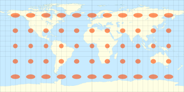
Equirectangular projection
Encyclopedia
Map projection
A map projection is any method of representing the surface of a sphere or other three-dimensional body on a plane. Map projections are necessary for creating maps. All map projections distort the surface in some fashion...
attributed to Marinus of Tyre
Marinus of Tyre
Marinus of Tyre, was a Greek geographer, cartographer and mathematician, who founded mathematical geography.-Biography and historical context:...
, who Ptolemy
Ptolemy
Claudius Ptolemy , was a Roman citizen of Egypt who wrote in Greek. He was a mathematician, astronomer, geographer, astrologer, and poet of a single epigram in the Greek Anthology. He lived in Egypt under Roman rule, and is believed to have been born in the town of Ptolemais Hermiou in the...
claims invented the projection about AD 100
100
Year 100 was a leap year starting on Wednesday of the Julian calendar. At the time, it was known as the Year of the Consulship of Traianus and Frontinus...
. The projection maps meridians
Meridian (geography)
A meridian is an imaginary line on the Earth's surface from the North Pole to the South Pole that connects all locations along it with a given longitude. The position of a point along the meridian is given by its latitude. Each meridian is perpendicular to all circles of latitude...
to equally spaced vertical straight lines, and circles of latitude
Circle of latitude
A circle of latitude, on the Earth, is an imaginary east-west circle connecting all locations that share a given latitude...
to evenly spread horizontal straight lines. The projection is neither equal area nor conformal. Because of the distortions introduced by this projection, it has little use in navigation
Navigation
Navigation is the process of monitoring and controlling the movement of a craft or vehicle from one place to another. It is also the term of art used for the specialized knowledge used by navigators to perform navigation tasks...
or cadastral mapping and finds its main use in thematic map
Thematic map
A thematic map is a type of map or chart especially designed to show a particular theme connected with a specific geographic area. These maps "can portray physical, social, political, cultural, economic, sociological, agricultural, or any other aspects of a city, state, region,nation , or...
ping. In particular, the plate carrée has become a de facto standard for global raster datasets, such as Celestia
Celestia
Celestia is a 3D astronomy program created by Chris Laurel. The program is based on the Hipparcos Catalogue and allows users to travel through an extensive universe, modeled after reality, at any speed, in any direction and at any time in history...
and NASA World Wind
NASA World Wind
World Wind is an open-source virtual globe developed by NASA and the open source community for use on personal computers. Old versions need Microsoft Windows but the more recent Java version, , is cross platform and provides a suite of . The World Wind Java version was awarded in November 2009...
, because of the particularly simple relationship between the position of an image pixel
Pixel
In digital imaging, a pixel, or pel, is a single point in a raster image, or the smallest addressable screen element in a display device; it is the smallest unit of picture that can be represented or controlled....
on the map and its corresponding geographic location on Earth.
Definition

where
 is the longitude from the central meridian of the projection,
 is the latitude
 are the standard parallels (north and south of the equator) where the scale of the projection is true.
Note that on the right side of the equation, the coordinates
 and
and  are linear, not angular, measurements. The point (0,0) is at the center of the resulting projection (in particular, this requires the input range to be [−π, π] rather than [0, 2π]). This projection maps longitude and latitude directly into x and y, hence is sometimes called the longitude-latitude projection.
The (French
French language
French is a Romance language spoken as a first language in France, the Romandy region in Switzerland, Wallonia and Brussels in Belgium, Monaco, the regions of Quebec and Acadia in Canada, and by various communities elsewhere. Second-language speakers of French are distributed throughout many parts...
, for square plate), is the special case where
 is zero.
See also
- CartographyCartographyCartography is the study and practice of making maps. Combining science, aesthetics, and technique, cartography builds on the premise that reality can be modeled in ways that communicate spatial information effectively.The fundamental problems of traditional cartography are to:*Set the map's...
- Cassini projectionCassini projectionThe Cassini projection is a map projection described by César-François Cassini de Thury in 1745. It is the transverse aspect of the equirectangular projection, in that the globe is first rotated so the central meridian becomes the "equator", and then the normal equirectangular projection is applied...
- Gall–Peters projection with resolution regarding the use of rectangular world maps
- PanoramaPanoramaA panorama is any wide-angle view or representation of a physical space, whether in painting, drawing, photography, film/video, or a three-dimensional model....
External links
- Global MODIS based satellite map The blue marble: land surface, ocean color and sea ice.
- Table of examples and properties of all common projections, from radicalcartography.net.
- Panoramic Equirectangular Projection, PanoTools wiki.