

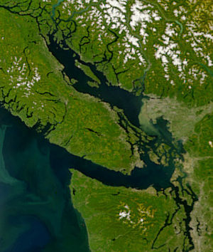
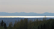
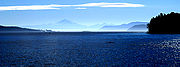
Strait of Georgia
Encyclopedia
Strait
A strait or straits is a narrow, typically navigable channel of water that connects two larger, navigable bodies of water. It most commonly refers to a channel of water that lies between two land masses, but it may also refer to a navigable channel through a body of water that is otherwise not...
between Vancouver Island
Vancouver Island
Vancouver Island is a large island in British Columbia, Canada. It is one of several North American locations named after George Vancouver, the British Royal Navy officer who explored the Pacific Northwest coast of North America between 1791 and 1794...
(as well as its nearby Gulf Islands
Gulf Islands
The Gulf Islands are the islands in the Strait of Georgia , between Vancouver Island and the mainland of British Columbia, Canada....
) and the mainland coast of British Columbia
British Columbia
British Columbia is the westernmost of Canada's provinces and is known for its natural beauty, as reflected in its Latin motto, Splendor sine occasu . Its name was chosen by Queen Victoria in 1858...
, Canada
Canada
Canada is a North American country consisting of ten provinces and three territories. Located in the northern part of the continent, it extends from the Atlantic Ocean in the east to the Pacific Ocean in the west, and northward into the Arctic Ocean...
. It is approximately 240 kilometres (149.1 mi) long and varies in width from 18.5 to 55 km (11.5 to 34.2 mi). Archipelagos and narrow channels mark each end of the Strait of Georgia, the Gulf Islands and San Juan Islands
San Juan Islands
The San Juan Islands are an archipelago in the northwest corner of the contiguous United States between the US mainland and Vancouver Island, British Columbia, Canada. The San Juan Islands are part of the U.S...
in the south, and the Discovery Islands
Discovery Islands
The Discovery Islands are the islands in the Discovery Passage between Vancouver Island and the mainland in British Columbia. These islands are sometimes considered to be part of the Northern Gulf Islands....
in the north. The main channels to the south are Haro Strait
Haro Strait
Haro Strait, often referred to as the Haro Straits because it is really a series of straits, is one of the main channels connecting the Strait of Georgia to the Strait of Juan de Fuca, separating Vancouver Island and the Gulf Islands in British Columbia, Canada from the San Juan Islands of...
and Rosario Strait
Rosario Strait
Rosario Strait is a strait in northern Washington state, separating Island and San Juan Counties. It extends from the Strait of Juan de Fuca about north to the Strait of Georgia...
, which connect the Strait of Georgia to the Strait of Juan de Fuca
Strait of Juan de Fuca
The Strait of Juan de Fuca is a large body of water about long that is the Salish Sea outlet to the Pacific Ocean...
. In the north, Discovery Passage
Discovery Passage
Discovery Passage is a channel that forms part of the Inside Passage between Vancouver Island and the Discovery Islands which lie off the British Columbia coast north of the Georgia Strait. It was named by Captain Vancouver for his ship, the HMS Discovery...
is the main channel connecting the Strait of Georgia to Johnstone Strait
Johnstone Strait
Johnstone Strait is a channel along the north east coast of Vancouver Island in British Columbia, Canada. Opposite the Vancouver Island coast, running north to south, are Hanson Island, West Cracroft Island, the mainland British Columbia Coast, Hardwick Island, West Thurlow Island and East...
.
The United States Geological Survey
United States Geological Survey
The United States Geological Survey is a scientific agency of the United States government. The scientists of the USGS study the landscape of the United States, its natural resources, and the natural hazards that threaten it. The organization has four major science disciplines, concerning biology,...
defines the southern boundary of the Strait of Georgia as a line running from East Point on Saturna Island
Saturna Island
Saturna Island is a mountainous island, about 31 km² in size, in the Southern Gulf Islands chain of British Columbia. It is situated approximately midway between the Lower Mainland of B.C. and Vancouver Island, and is the most easterly of the Gulf Islands. It is surrounded on three sides by...
to Patos Island
Patos Island
Patos Island is a small island in the San Juan Islands of the U.S. state of Washington. Since 1893, it has been home to the Patos Island Lighthouse, guiding vessels through Boundary Pass between Canada and the United States....
, Sucia Island
Sucia Island
Sucia Island is located north of Orcas Island in the San Juan Islands, San Juan County, Washington, USA. It is the largest of an archipelago of ten islands including Sucia Island, Little Sucia, Ewing, Justice, Herndon, the Cluster Islands islets, and several smaller, unnamed islands. The group of...
, and Matia Island
Matia Island
Matia Island is an island in the San Juan Islands of the U.S. state of Washington. The Island's entire 145 acres comes under the protection of the U.S. Fish and Wildlife Service and is cooperatively managed by the Washington State Parks and Recreation Commission. Matia Island is actually a...
, then to Point Migley on Lummi Island
Lummi Island
Lummi Island lies at the southwest corner of Whatcom County, Washington, USA, between the mainland part of the county and offshore San Juan County. The Lummi Indian Reservation is situated on a peninsula east of the island, but does not include Lummi Island. The island has a land area of...
. This line touches the northern edges of Rosario Strait
Rosario Strait
Rosario Strait is a strait in northern Washington state, separating Island and San Juan Counties. It extends from the Strait of Juan de Fuca about north to the Strait of Georgia...
, which leads south to the Strait of Juan de Fuca, and Boundary Pass
Boundary Pass
Boundary Pass is a strait that runs for about along the boundary between the U.S. state of Washington and the Canadian province of British Columbia. It connects Haro Strait to the south with the Strait of Georgia to the north....
, which leads south to Haro Strait
Haro Strait
Haro Strait, often referred to as the Haro Straits because it is really a series of straits, is one of the main channels connecting the Strait of Georgia to the Strait of Juan de Fuca, separating Vancouver Island and the Gulf Islands in British Columbia, Canada from the San Juan Islands of...
and the Strait of Juan de Fuca.
The mean depth of the Strait of Georgia is 156 metres (511.8 ft), with a maximum depth of 420 metres (1,378 ft). Its surface area is approximately 6800 square kilometres (2,625.5 sq mi). The Fraser River
Fraser River
The Fraser River is the longest river within British Columbia, Canada, rising at Fraser Pass near Mount Robson in the Rocky Mountains and flowing for , into the Strait of Georgia at the city of Vancouver. It is the tenth longest river in Canada...
accounts for roughly 80 percent of the fresh water entering the strait. Water circulates in the strait in a general counterclockwise direction.
The term "Gulf of Georgia" includes waters other than the Georgia Strait proper, such as the inter-insular straits and channels of the Gulf Islands
Gulf Islands
The Gulf Islands are the islands in the Strait of Georgia , between Vancouver Island and the mainland of British Columbia, Canada....
, and may refer to communities on the shore of southern Vancouver Island. As defined by George Vancouver
George Vancouver
Captain George Vancouver RN was an English officer of the British Royal Navy, best known for his 1791-95 expedition, which explored and charted North America's northwestern Pacific Coast regions, including the coasts of contemporary Alaska, British Columbia, Washington and Oregon...
in 1792, the Gulf of Georgia included all the inland waters beyond the eastern end of the Strait of Juan de Fuca, including Puget Sound
Puget Sound
Puget Sound is a sound in the U.S. state of Washington. It is a complex estuarine system of interconnected marine waterways and basins, with one major and one minor connection to the Strait of Juan de Fuca and the Pacific Ocean — Admiralty Inlet being the major connection and...
, Bellingham Bay
Bellingham Bay
Bellingham Bay is a bay located on the northern Pacific coast of Washington state in the United States. It is separated from the Strait of Georgia on the west by the Lummi Peninsula, Portage Island, and Lummi Island. It is bordered on the east by Bellingham, Washington, to the south-east by the...
, the waters around the San Juan Islands
San Juan Islands
The San Juan Islands are an archipelago in the northwest corner of the contiguous United States between the US mainland and Vancouver Island, British Columbia, Canada. The San Juan Islands are part of the U.S...
, as well as the Strait of Georgia.
Islands
Several major islands are in the strait, the largest being Texada IslandTexada Island
Texada Island is the largest island in the Strait of Georgia of British Columbia, Canada. Its northern tip is located about southwest of the city of Powell River and west of the Sechelt Peninsula on the Sunshine Coast. A former mining and logging area, the island still has a few quarries and old...
and Lasqueti Island
Lasqueti Island
Lasqueti Island is an island off the east coast of Vancouver Island in the Strait of Georgia, Powell River Regional District, British Columbia, Canada. A passenger-only ferry connects the island to the community of French Creek, near Parksville...
. The strait is a major navigation channel on the west coast of North America
North America
North America is a continent wholly within the Northern Hemisphere and almost wholly within the Western Hemisphere. It is also considered a northern subcontinent of the Americas...
, owing to the presence of the port of Vancouver, and also due to its role as the southern entrance to the infracoastal route known as the Inside Passage
Inside Passage
The Inside Passage is a coastal route for oceangoing vessels along a network of passages which weave through the islands on the Pacific coast of North America. The route extends from southeastern Alaska, in the United States, through western British Columbia, in Canada, to northwestern Washington...
. The two busiest routes of the BC Ferries
BC Ferries
British Columbia Ferry Services Inc. or BC Ferries is a de facto Crown Corporation that provides all major passenger and vehicle ferry services for coastal and island communities in the Canadian province of British Columbia...
system cross the strait, between Tsawwassen (south of Vancouver) and Swartz Bay (near Victoria
Victoria, British Columbia
Victoria is the capital city of British Columbia, Canada and is located on the southern tip of Vancouver Island off Canada's Pacific coast. The city has a population of about 78,000 within the metropolitan area of Greater Victoria, which has a population of 360,063, the 15th most populous Canadian...
) and between Horseshoe Bay (north of Vancouver) and Nanaimo
Nanaimo, British Columbia
Nanaimo is a city on Vancouver Island in British Columbia, Canada. It has been dubbed the "Bathtub Racing Capital of the World" and "Harbour City". Nanaimo is also sometimes referred to as the "Hub City" because of its central location on Vancouver Island and due to the layout of the downtown...
.
History
First Nations communities have surrounded the Strait of Georgia for thousands of years. The first European exploration of the area was undertaken by Captain Jose Maria NarvaezJosé María Narváez
José María Narváez was a Spanish naval officer, explorer, and navigator notable for his work in the Pacific Northwest of present-day Canada. In 1791, as commander of the schooner Santa Saturnina, he led the first European exploration of the Strait of Georgia, including a landing on present-day...
and Pilot Juan Carrasco
Juan Carrasco (explorer)
Juan Carrasco was a Spanish naval officer, explorer, and navigator. He is remembered mainly for his work in the Pacific Northwest during the late 18th century. He was second in command of the 1791 voyage of José María Narváez, the first European exploration of the Strait of Georgia.Many details...
of Spain
Spain
Spain , officially the Kingdom of Spain languages]] under the European Charter for Regional or Minority Languages. In each of these, Spain's official name is as follows:;;;;;;), is a country and member state of the European Union located in southwestern Europe on the Iberian Peninsula...
in 1791. At this time Francisco de Eliza
Francisco de Eliza
Francisco de Eliza y Reventa was a Spanish naval officer, navigator, and explorer. He is remembered mainly for his work in the Pacific Northwest...
gave the strait the name "Gran Canal de Nuestra Señora del Rosario la Marinera." In 1792, it was renamed for King George III
George III of the United Kingdom
George III was King of Great Britain and King of Ireland from 25 October 1760 until the union of these two countries on 1 January 1801, after which he was King of the United Kingdom of Great Britain and Ireland until his death...
as the "Gulf of Georgia" by George Vancouver
George Vancouver
Captain George Vancouver RN was an English officer of the British Royal Navy, best known for his 1791-95 expedition, which explored and charted North America's northwestern Pacific Coast regions, including the coasts of contemporary Alaska, British Columbia, Washington and Oregon...
of Great Britain
Kingdom of Great Britain
The former Kingdom of Great Britain, sometimes described as the 'United Kingdom of Great Britain', That the Two Kingdoms of Scotland and England, shall upon the 1st May next ensuing the date hereof, and forever after, be United into One Kingdom by the Name of GREAT BRITAIN. was a sovereign...
, during his extensive expedition
Vancouver Expedition
The Vancouver Expedition was a four-and-a-half-year voyage of exploration and diplomacy, commanded by Captain George Vancouver. The expedition circumnavigated the globe, touched five continents and changed the course of history for the indigenous nations and several European empires and their...
along the west coast of North America
North America
North America is a continent wholly within the Northern Hemisphere and almost wholly within the Western Hemisphere. It is also considered a northern subcontinent of the Americas...
. Vancouver designated the mainland in this region as New Georgia, and areas farther north as New Hanover and New Bremen.
The June 23, 1946 Vancouver Island earthquake
1946 Vancouver Island earthquake
The 1946 Vancouver Island earthquake was a 7.3 magnitude earthquake that struck Vancouver Island, on the Coast of British Columbia, Canada, at 10:15 a.m. on Sunday, June 23, 1946. The main shock epicenter occurred in the Forbidden Plateau area northwest of Courtenay...
shocked the Strait of Georgia region, causing the bottom of Deep Bay to sink between 2.7 and 25.6 m (8.9 and 84 ft).
Cities
Courtenay, British Columbia
Courtenay is a city on the east coast of Vancouver Island, in the Canadian province of British Columbia. It is the largest city in the area commonly known as the Comox Valley, and it is the seat of the Comox Valley Regional District which replaced the Comox-Strathcona Regional District...
, Comox
Comox, British Columbia
Comox is a town of 12,000 people located on a small peninsula in the Georgia Strait on the eastern coast of Vancouver Island, British Columbia. The warm dry summers, mild winters, fertile soil and abundant sea life attracted First Nations thousands of years ago, who called the area kw’umuxws...
, Qualicum Beach
Qualicum Beach, British Columbia
Qualicum Beach is a town in the Regional District of Nanaimo, British Columbia, Canada. As of the 2006 census, the town had 8,502 people.On the Strait of Georgia on the north-eastern coast of Vancouver Island in the shadow of Mount Arrowsmith, the community has been a popular tourist destination,...
, Parksville
Parksville, British Columbia
-Demographics:Parksville had a population of 10,993 people in 2006, which was an increase of 6.5% from the 2001 census count. The median household income in 2006 for Parksville was $55,524, which is below the British Columbia provincial average of $62,346....
, Lantzville
Lantzville, British Columbia
Lantzville is a coastal community on the east side of Vancouver Island, British Columbia, Canada along the western shore of Strait of Georgia and immediately north of the City of Nanaimo, British Columbia....
, and Nanaimo
Nanaimo, British Columbia
Nanaimo is a city on Vancouver Island in British Columbia, Canada. It has been dubbed the "Bathtub Racing Capital of the World" and "Harbour City". Nanaimo is also sometimes referred to as the "Hub City" because of its central location on Vancouver Island and due to the layout of the downtown...
on the western shore, as well as Powell River
Powell River, British Columbia
Powell River is a city on the northern Sunshine Coast of southwestern British Columbia, Canada. Most of its population lives near the eastern shores of Malaspina Strait, that part of the larger Georgia Strait between Texada Island and the Mainland...
, Sechelt, Gibsons
Gibsons, British Columbia
Gibsons is a coastal community of 4,200 located in southwestern British Columbia, Canada on the Strait of Georgia. It is the main marine gateway to the Sunshine Coast....
, and Greater Vancouver on the east. Across the border in the United States
United States
The United States of America is a federal constitutional republic comprising fifty states and a federal district...
, Bellingham, Washington
Bellingham, Washington
Bellingham is the largest city in, and the county seat of, Whatcom County in the U.S. state of Washington. It is the twelfth-largest city in the state. Situated on Bellingham Bay, Bellingham is protected by Lummi Island, Portage Island, and the Lummi Peninsula, and opens onto the Strait of Georgia...
and other communities also lie on the eastern shore. Other settlements on Vancouver Island (such as Duncan
Duncan, British Columbia
Duncan is a city on southern Vancouver Island in British Columbia, Canada.-History:The community is named after William Chalmers Duncan . He arrived in Victoria in May 1862, then in August of that year he was one of the party of a hundred settlers which Governor Douglas took to Cowichan Bay...
) and the mainland are separated from Georgia Strait itself by islands.
The Strait of Georgia is known as a premier scuba diving
Scuba diving
Scuba diving is a form of underwater diving in which a diver uses a scuba set to breathe underwater....
and whale watching
Whale watching
Whale watching is the practice of observing whales and other cetaceans in their natural habitat. Whales are watched most commonly for recreation but the activity can also serve scientific or educational purposes. A 2009 study, prepared for IFAW, estimated that 13 million people went whale watching...
location.
In 1967, the Georgia Strait inspired the name of Vancouver's alternative newspaper, The Georgia Straight
The Georgia Straight
The Georgia Straight is a free Canadian weekly news and entertainment newspaper published in Vancouver, British Columbia, by the Vancouver Free Press Publishing Corp...
, which has published continuously since.
Georgia Strait bridge proposal
Seymour Narrows
Seymour Narrows is a section of the Discovery Passage in British Columbia known for strong tidal currents. Discovery Passage lies between Vancouver Island at Menzies Bay, British Columbia and Quadra Island except at its northern end where the eastern shoreline is Sonora Island...
at Menzies Bay with a rail bridge for the then-proposed Canadian Pacific Railway to link Victoria, via Bute Inlet and the Yellowhead Pass, with the rest of Canada. Later proposals have focussed on bridging the Strait of Georgia itself, which is much wider than Seymour Narrows.
A proposed modern road bridge connecting the Greater Vancouver Regional District to Vancouver Island
Vancouver Island
Vancouver Island is a large island in British Columbia, Canada. It is one of several North American locations named after George Vancouver, the British Royal Navy officer who explored the Pacific Northwest coast of North America between 1791 and 1794...
in the manner of the Chesapeake Bay Bridge Tunnel, has been discussed for decades, ever since the commencement of service by BC Ferries. Some crossing design suggestions include a partly floating, partly submerged tunnel to allow ship traffic to move freely. The hurricane-force windstorms of Typhoon Freda in 1962 and of December 2006 call into question the safety of such a project.
Proponents of the bridge argue that a reliable link to Vancouver Island from mainland British Columbia will increase tourism and growth on Vancouver Island. Opponents argue that construction of a bridge will result in further urbanization
Urbanization
Urbanization, urbanisation or urban drift is the physical growth of urban areas as a result of global change. The United Nations projected that half of the world's population would live in urban areas at the end of 2008....
of the island and that the area's environment will be negatively affected by construction and the increase in tourism. Other potential problems are the width and depth of the strait and the soft consistency of the strait floor, as well as high seismic activity
Seismology
Seismology is the scientific study of earthquakes and the propagation of elastic waves through the Earth or through other planet-like bodies. The field also includes studies of earthquake effects, such as tsunamis as well as diverse seismic sources such as volcanic, tectonic, oceanic,...
in the Vancouver Island region, and the fact that the strait is heavily used as a navigation channel. The strait is far deeper than any bridged body of water in the world.
Former B.C. cabinet minister Dr. Patrick McGeer, a research neuroscientist and a science advocate, has repeatedly advanced the proposal in recent decades. In a CKNW news item broadcast in August 2008, McGeer said he thinks the idea just needs "a visionary politician" to support it. McGeer still has the conceptual model of the bridge that was displayed at Expo 86
Expo 86
The 1986 World Exposition on Transportation and Communication, or simply Expo '86, was a World's Fair held in Vancouver, British Columbia, Canada from Friday, May 2 until Monday, October 13, 1986...
. The idea has formal opposition in the form of an Islands Trust policy banning the building of any bridges or tunnels connecting the Gulf Islands to the Mainland or Vancouver Island.
Salish Sea
In March 2008, the Chemainus First NationChemainus First Nation
The Stz'uminus First Nation is a First Nations government located in southeastern Vancouver Island, British Columbia, Canada, near the town of Ladysmith, British Columbia. Stz'uminus First Nation is a member government of the Naut'sa mawt Tribal Council...
proposed renaming the strait the "Salish Sea
Salish Sea
The name Salish Sea was coined only in the late 20th century, and was officially recognized by the United States in 2009 and by Canada in 2010, to describe the coastal waterways surrounding southern Vancouver Island and Puget Sound between Canada and the United States of America...
," an idea that reportedly met with approval by B.C.'s Aboriginal Relations Minister Mike de Jong
Mike de Jong
Mike de Jong, Q.C. is a politician from British Columbia, Canada.-Politics and career:He was appointed Minister of Health Mike de Jong on March 14, 2011. He has previously held the post of Attorney General and Government House Leader, Minister of Public Safety and Solicitor General and Minister of...
, who pledged to put it before the B.C. cabinet
Executive Council of British Columbia
The Executive Council of British Columbia is the cabinet of that Canadian province....
for discussion. Making the name "Salish Sea" official required a formal application to the Geographical Names Board of Canada
Geographical Names Board of Canada
Geographical Names Board of Canada is a national committee of the Canadian Government Department of Natural Resources which authorizes the names used on official federal government maps of Canada since 1897. The board consists of 27 members including one from each of the provinces and territories...
. A parallel American movement promoting the name had a different definition, combining of the Strait of Juan de Fuca
Strait of Juan de Fuca
The Strait of Juan de Fuca is a large body of water about long that is the Salish Sea outlet to the Pacific Ocean...
and Puget Sound
Puget Sound
Puget Sound is a sound in the U.S. state of Washington. It is a complex estuarine system of interconnected marine waterways and basins, with one major and one minor connection to the Strait of Juan de Fuca and the Pacific Ocean — Admiralty Inlet being the major connection and...
as well as the Strait of Georgia and related waters under the name Salish Sea. This latter definition was made official in 2009 by geographic boards of Canada and the United States.
In October 2009, the Washington state Board of Geographic Names approved the Salish Sea toponym, not to replace the names of the Strait of Georgia, Puget Sound, and Strait of Juan de Fuca, but instead as a collective term for all three. The British Columbia Geographical Names Office passed a resolution recommending that the name only be adopted by the Geographical Names Board of Canada
Geographical Names Board of Canada
Geographical Names Board of Canada is a national committee of the Canadian Government Department of Natural Resources which authorizes the names used on official federal government maps of Canada since 1897. The board consists of 27 members including one from each of the provinces and territories...
should its US counterpart approve the name change. The United States Board on Geographic Names
United States Board on Geographic Names
The United States Board on Geographic Names is a United States federal body whose purpose is to establish and maintain uniform usage of geographic names throughout the U.S. government.-Overview:...
approved the name on November 12, 2009 and Canada approved it in 2010.
See also
- Howe SoundHowe SoundHowe Sound is a roughly triangular sound, actually a network of fjords situated immediately northwest of Vancouver.-Geography:Howe Sound's mouth at the Strait of Georgia is situated between West Vancouver and the Sunshine Coast. The sound is triangular shaped, open on its southeast towards the...
- Sunshine Coast
- Burrard PeninsulaBurrard PeninsulaThe Burrard Peninsula is a peninsula in the Lower Mainland region of southwestern British Columbia, Canada, lying between Burrard Inlet to the north and the Fraser River to the south, and bounded by Georgia Strait on the west and the Pitt River on the east...
- Georgia Basin
- Queen Charlotte StraitQueen Charlotte StraitQueen Charlotte Strait is a strait between Vancouver Island and the mainland of British Columbia, Canada. It connects Queen Charlotte Sound with Johnstone Strait, Discovery Passage and then to the Strait of Georgia and Puget Sound...
- Puget SoundPuget SoundPuget Sound is a sound in the U.S. state of Washington. It is a complex estuarine system of interconnected marine waterways and basins, with one major and one minor connection to the Strait of Juan de Fuca and the Pacific Ocean — Admiralty Inlet being the major connection and...
- Royal eponyms in CanadaRoyal eponyms in CanadaIn Canada, a number of sites and structures are named for royal individuals, whether a member of the past French Royal Family, British Royal Family, or present Canadian Royal Family, thus reflecting the country's status as a constitutional monarchy under the Canadian Crown.-King Francis I:-Queen...
- Georgia Straight (newspaper)
External links
- Map and information from the Georgia Strait Alliance
- A Potential Fixed Link to Vancouver Island - report from the British Columbia Ministry of Transportation
- Google Satellite Image, Accessed August 7, 2006