
Powell River, British Columbia
Encyclopedia
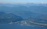
Powell River is a city on the northern Sunshine Coast
of southwestern British Columbia
, Canada
. Most of its population lives near the eastern shores of Malaspina Strait
, that part of the larger Georgia Strait between Texada Island
and the Mainland. With two intervening long, steep sided fjords inhibiting the construction of a contiguous road connection with Vancouver to the south, geographical surroundings explain Powell River's remoteness as a community, despite a relative proximity to Vancouver
and other populous areas of the BC Coast
. The city is the seat of the Powell River Regional District
.
 Prior to the establishment of any settlement in the area, the area was inhabited by Coast Salish
peoples, and was used as a landing spot for gold prospectors coming from Vancouver Island
who where treading their way to the Fraser River to find quick fortune prior to the creation of the Cariboo Road
.
The river was named for Israel Wood Powell
, who was at that time superintendent of Indian Affairs for BC. He was travelling up the coast of BC in the 1880s and the river and lake were named in his honour.
The pulp mill was started in 1908, with a corresponding townsite company town commenced in 1910: the first roll of paper was produced in 1912. Similarly, large logging companies had earlier moved in to take advantage of the huge timber. Brooks, Scanlon & Obrien; Bloedel, Stewart and Welch; and Theodosia Logging were but a few logging companies, with the Brooks brothers and M.J. Scanlon forming the Powell River Company, western Canada's first pulp and paper mill. The Historic Townsite was designated a National Historic District by Parks and Monuments Canada in 1995, recognizing the exceptionally well preserved early 20th Century planned community, rooted firmly in the Garden City Design Movement and the Arts and Crafts philosophy.
When the British Columbia Credit Unions Act was passed in 1939, a study club organized by local millworkers secured the first charter with a deposit of $48.30. The mill provided a small office space at very low rent in the early years. By 1955, when the Powell River Credit Union (now 'First Credit Union') moved into a permanent office, it had over 3,000 members and $1 million in assets.
The mill in Powell River was at one time the largest pulp and paper mill in the world. In its prime, one in every 25 newspapers in the world was printed on paper from the Powell River mill. However, since then it has significantly cut back on production and now produces newsprint and specialty papers for Catalyst Paper
. The mill is down-sizing, and only 3 paper machines (#9, #10 and #11) remain in production, thus laying off hundreds of employees. The subsequent diversification of the local economy led to an increased focus on ecotourism
and the arts, in addition to more traditional resources like mining, fishing, and general forestry. In recognition of its strong arts and cultural programs, Powell River was named a "Cultural Capital of Canada" in 2004.
The population of the Powell River Regional District is (2001 Census) 19,765. Of this 12,983 live in the City of Powell River. Although these numbers have remained static since the 1970s, recent (2006) figures indicate that the regional population is showing signs of renewed growth, and may have reached 22,000.
The Powell River area is the traditional home to the Tla'Amin nation of the Mainland Comox branch of the Coast Salish peoples, who still reside there to this day in their traditional village site, which is named Sliammon (the usual English adaptation of Tla'Amin).
s) banked by mountainous terrain have made roads to other areas of the BC mainland thus far unfeasible. BC Ferries
serves Powell River from Comox
on Vancouver Island
to the west, and from the Sunshine Coast
to the south east, via a route from Earl's Cove near Skookumchuck Narrows
. Since the Sunshine Coast is similarly isolated from the rest of the BC mainland, vehicles traveling from Vancouver must take two ferry rides to reach Powell River (across Howe Sound
and the Jervis Inlet if travelling via Sechelt
, and across Georgia Strait twice if going via Nanaimo
). Powell River is also accessible via plane, either private or via Pacific Coastal Airlines
, which offers 20 to 25 minute flights between Powell River Airport
and the South Terminal of Vancouver's International Airport
.
. On average, the CWH is the rainiest biogeoclimatic zone in British Columbia. The zone typically has a cool mesothermal climate: cool summers (although hot dry spells can be frequent) and mild winters. Mean annual temperature is about 8 °C (46.4 °F) and ranges from 5.2 °C (41.4 °F) to 10.5 °C (50.9 °F) among the CWH subzones. The mean monthly temperature is above 10 °C (50 °F) for 4–6 months of the year. The mean temperature of the coldest month is 0.2 °C (32.4 °F) and ranges from -6.6 C to 4.7 °C (40.5 °F) among the subzones. Mean annual precipitation for the zone as a whole is 2228 mm (87.7 in), and ranges from 1000 mm (39.4 in) to 4400 mm (173.2 in) (and probably more in some areas). Less than 15% of total precipitation occurs as snowfall in the south, but as much as 40-50% in the northern parts of the zone.
Sunshine Coast, British Columbia
The Sunshine Coast is a region of the southern mainland coast of British Columbia, on the eastern shore of the Strait of Georgia, and just northwest of Greater Vancouver...
of southwestern British Columbia
British Columbia
British Columbia is the westernmost of Canada's provinces and is known for its natural beauty, as reflected in its Latin motto, Splendor sine occasu . Its name was chosen by Queen Victoria in 1858...
, Canada
Canada
Canada is a North American country consisting of ten provinces and three territories. Located in the northern part of the continent, it extends from the Atlantic Ocean in the east to the Pacific Ocean in the west, and northward into the Arctic Ocean...
. Most of its population lives near the eastern shores of Malaspina Strait
Malaspina Strait
Malaspina Strait is a strait in the northern Gulf of Georgia-Sunshine Coast region of British Columbia, Canada. It separates Texada Island from the upper Sunshine Coast-Malaspina Peninsula area on the adjacent mainland....
, that part of the larger Georgia Strait between Texada Island
Texada Island
Texada Island is the largest island in the Strait of Georgia of British Columbia, Canada. Its northern tip is located about southwest of the city of Powell River and west of the Sechelt Peninsula on the Sunshine Coast. A former mining and logging area, the island still has a few quarries and old...
and the Mainland. With two intervening long, steep sided fjords inhibiting the construction of a contiguous road connection with Vancouver to the south, geographical surroundings explain Powell River's remoteness as a community, despite a relative proximity to Vancouver
Vancouver
Vancouver is a coastal seaport city on the mainland of British Columbia, Canada. It is the hub of Greater Vancouver, which, with over 2.3 million residents, is the third most populous metropolitan area in the country,...
and other populous areas of the BC Coast
British Columbia Coast
The British Columbia Coast or BC Coast is Canada's western continental coastline on the Pacific Ocean. The usage is synonymous with the term West Coast of Canada....
. The city is the seat of the Powell River Regional District
Powell River Regional District, British Columbia
The Regional District of Powell River is a regional district in the Canadian province of British Columbia. It includes the City of Powell River and a number of unincorporated areas...
.
History
Coast Salish
Coast Salish languages are a subgroup of the Salishan language family. These languages are spoken by First Nations or Native American peoples inhabiting the territory that is now the southwest coast of British Columbia around the Strait of Georgia and Washington state around Puget Sound...
peoples, and was used as a landing spot for gold prospectors coming from Vancouver Island
Vancouver Island
Vancouver Island is a large island in British Columbia, Canada. It is one of several North American locations named after George Vancouver, the British Royal Navy officer who explored the Pacific Northwest coast of North America between 1791 and 1794...
who where treading their way to the Fraser River to find quick fortune prior to the creation of the Cariboo Road
Cariboo Road
The Cariboo Road was a project initiated in 1860 by the colonial Governor of British Columbia, James Douglas...
.
The river was named for Israel Wood Powell
Israel Wood Powell
Israel Wood Powell was a doctor, businessman and politician in British Columbia. He served in the Legislative Assembly of Vancouver Island from 1863 to 1866....
, who was at that time superintendent of Indian Affairs for BC. He was travelling up the coast of BC in the 1880s and the river and lake were named in his honour.
The pulp mill was started in 1908, with a corresponding townsite company town commenced in 1910: the first roll of paper was produced in 1912. Similarly, large logging companies had earlier moved in to take advantage of the huge timber. Brooks, Scanlon & Obrien; Bloedel, Stewart and Welch; and Theodosia Logging were but a few logging companies, with the Brooks brothers and M.J. Scanlon forming the Powell River Company, western Canada's first pulp and paper mill. The Historic Townsite was designated a National Historic District by Parks and Monuments Canada in 1995, recognizing the exceptionally well preserved early 20th Century planned community, rooted firmly in the Garden City Design Movement and the Arts and Crafts philosophy.
When the British Columbia Credit Unions Act was passed in 1939, a study club organized by local millworkers secured the first charter with a deposit of $48.30. The mill provided a small office space at very low rent in the early years. By 1955, when the Powell River Credit Union (now 'First Credit Union') moved into a permanent office, it had over 3,000 members and $1 million in assets.
The mill in Powell River was at one time the largest pulp and paper mill in the world. In its prime, one in every 25 newspapers in the world was printed on paper from the Powell River mill. However, since then it has significantly cut back on production and now produces newsprint and specialty papers for Catalyst Paper
Catalyst Paper
Catalyst Paper Corporation is a Canadian paper manufacturer. Based in Richmond, British Columbia, the company produces paper and pulp for commercial printers, publishers and paper manufacturers in North America, Latin America, the Pacific Rim and Europe...
. The mill is down-sizing, and only 3 paper machines (#9, #10 and #11) remain in production, thus laying off hundreds of employees. The subsequent diversification of the local economy led to an increased focus on ecotourism
Ecotourism
Ecotourism is a form of tourism visiting fragile, pristine, and usually protected areas, intended as a low impact and often small scale alternative to standard commercial tourism...
and the arts, in addition to more traditional resources like mining, fishing, and general forestry. In recognition of its strong arts and cultural programs, Powell River was named a "Cultural Capital of Canada" in 2004.
The population of the Powell River Regional District is (2001 Census) 19,765. Of this 12,983 live in the City of Powell River. Although these numbers have remained static since the 1970s, recent (2006) figures indicate that the regional population is showing signs of renewed growth, and may have reached 22,000.
The Powell River area is the traditional home to the Tla'Amin nation of the Mainland Comox branch of the Coast Salish peoples, who still reside there to this day in their traditional village site, which is named Sliammon (the usual English adaptation of Tla'Amin).
Transportation
While not on an island, Powell River is accessible to vehicles only by ferry, in fact a sequence of ferries for most of the rest of the continent; the surrounding inlets (fjordFjord
Geologically, a fjord is a long, narrow inlet with steep sides or cliffs, created in a valley carved by glacial activity.-Formation:A fjord is formed when a glacier cuts a U-shaped valley by abrasion of the surrounding bedrock. Glacial melting is accompanied by rebound of Earth's crust as the ice...
s) banked by mountainous terrain have made roads to other areas of the BC mainland thus far unfeasible. BC Ferries
BC Ferries
British Columbia Ferry Services Inc. or BC Ferries is a de facto Crown Corporation that provides all major passenger and vehicle ferry services for coastal and island communities in the Canadian province of British Columbia...
serves Powell River from Comox
Comox, British Columbia
Comox is a town of 12,000 people located on a small peninsula in the Georgia Strait on the eastern coast of Vancouver Island, British Columbia. The warm dry summers, mild winters, fertile soil and abundant sea life attracted First Nations thousands of years ago, who called the area kw’umuxws...
on Vancouver Island
Vancouver Island
Vancouver Island is a large island in British Columbia, Canada. It is one of several North American locations named after George Vancouver, the British Royal Navy officer who explored the Pacific Northwest coast of North America between 1791 and 1794...
to the west, and from the Sunshine Coast
Sunshine Coast, British Columbia
The Sunshine Coast is a region of the southern mainland coast of British Columbia, on the eastern shore of the Strait of Georgia, and just northwest of Greater Vancouver...
to the south east, via a route from Earl's Cove near Skookumchuck Narrows
Skookumchuck Narrows
Skookumchuck Narrows forms the entrance of Sechelt Inlet on British Columbia's Sunshine Coast in Canada. Before broadening into Sechelt Inlet, all of its tidal flow together with that of Salmon Inlet and Narrows Inlet must pass through Sechelt Rapids. At peak flows, whitecaps and whirlpools form at...
. Since the Sunshine Coast is similarly isolated from the rest of the BC mainland, vehicles traveling from Vancouver must take two ferry rides to reach Powell River (across Howe Sound
Howe Sound
Howe Sound is a roughly triangular sound, actually a network of fjords situated immediately northwest of Vancouver.-Geography:Howe Sound's mouth at the Strait of Georgia is situated between West Vancouver and the Sunshine Coast. The sound is triangular shaped, open on its southeast towards the...
and the Jervis Inlet if travelling via Sechelt
Sechelt, British Columbia
The District Municipality of Sechelt is on the lower Sunshine Coast of British Columbia. Approximately 50 km northwest of Vancouver, Sechelt is accessible to the mainland of British Columbia via a 40 minute ferry trip between Horseshoe Bay and Langdale, and a 25 minute drive from Langdale...
, and across Georgia Strait twice if going via Nanaimo
Nanaimo, British Columbia
Nanaimo is a city on Vancouver Island in British Columbia, Canada. It has been dubbed the "Bathtub Racing Capital of the World" and "Harbour City". Nanaimo is also sometimes referred to as the "Hub City" because of its central location on Vancouver Island and due to the layout of the downtown...
). Powell River is also accessible via plane, either private or via Pacific Coastal Airlines
Pacific Coastal Airlines
Pacific Coastal Airlines is an airline based in Richmond, British Columbia, Canada. It operates scheduled, charter and cargo services to destinations in British Columbia. Its main base is Vancouver International Airport, with a hub at Port Hardy Airport....
, which offers 20 to 25 minute flights between Powell River Airport
Powell River Airport
Powell River Airport, , is located adjacent to Powell River, British Columbia, Canada....
and the South Terminal of Vancouver's International Airport
Vancouver International Airport
Vancouver International Airport is located on Sea Island in Richmond, British Columbia, Canada, about from Downtown Vancouver. In 2010 it was the second busiest airport in Canada by aircraft movements and passengers , behind Toronto Pearson International Airport, with non-stop flights daily to...
.
City of Powell River
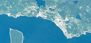
The City of Powell River includes the original Townsite, as well as the more populous Westview, and the Cranberry and Wildwood areas. On October 15, 2005, coinciding with its 50th anniversary of incorporation, Powell River was officially designated a city.Demographics
Powell River had a population of 12,957 people in 2006, which was a decrease of 0.2% from the 2001 census count. The median household income in 2005 for Powell River was $46,777, which is below the British Columbia provincial average of $52,709.Geography and climate
Powell River is situated within a temperate rainforest, Coastal Western Hemlock biogeoclimatic zoneBiogeoclimatic zones of British Columbia
Biogeoclimatic zones of British Columbia are a classification system ciosed by the British Columbia Ministry of Forests for the Canadian province's many different ecosystems...
. On average, the CWH is the rainiest biogeoclimatic zone in British Columbia. The zone typically has a cool mesothermal climate: cool summers (although hot dry spells can be frequent) and mild winters. Mean annual temperature is about 8 °C (46.4 °F) and ranges from 5.2 °C (41.4 °F) to 10.5 °C (50.9 °F) among the CWH subzones. The mean monthly temperature is above 10 °C (50 °F) for 4–6 months of the year. The mean temperature of the coldest month is 0.2 °C (32.4 °F) and ranges from -6.6 C to 4.7 °C (40.5 °F) among the subzones. Mean annual precipitation for the zone as a whole is 2228 mm (87.7 in), and ranges from 1000 mm (39.4 in) to 4400 mm (173.2 in) (and probably more in some areas). Less than 15% of total precipitation occurs as snowfall in the south, but as much as 40-50% in the northern parts of the zone.
Education
A regional campus of Vancouver Island University is located in Powell River as well as Brooks Secondary School(high school), Oceanview Middle School, Assumption Catholic School (middle schools), James Thompson, Henderson, Edgehill, Grief Point and Kelly Creek (elementary schools)Power supply
West of Saltery Bay a powerline crosses a fjord on a span of 3.1 kilometres (1.9 mi). This may be the second-longest powerline span in Canada.See also
- Cortes IslandCortes Island, British ColumbiaCortes Island is one of the archipelago known as the Discovery Islands in British Columbia, Canada which lie beyond the northern end of the Gulf of Georgia, between Vancouver Island and the British Columbia Mainland. Cortes lies on the far side of Quadra Island from the city of Campbell River,...
- Hernando IslandHernando IslandHernando Island is one of the Discovery Islands near Powell River, British Columbia, Canada. Along with the nearby Cortes Island, it was presumably named in 1792 by Valdés and Galiano after Hernán Cortés, the Spanish conqueror of Mexico....
- Savary IslandSavary IslandSavary Island is an island in British Columbia, Canada. Located in the northern part of the Strait of Georgia, it is northwest of Vancouver. It is approximately 0.8-1.5 km wide and long. It has a permanent population of 100...
- Texada IslandTexada IslandTexada Island is the largest island in the Strait of Georgia of British Columbia, Canada. Its northern tip is located about southwest of the city of Powell River and west of the Sechelt Peninsula on the Sunshine Coast. A former mining and logging area, the island still has a few quarries and old...
- Harwood IslandHarwood Island (British Columbia)Harwood Island is a small island that lies off the coast of Powell River, BC. It is an Indian reserve and is part of the traditional territory of the Sliammon First Nation. It is a popular weekend destination during the summer season for tourists and residents of Powell River.An excellent day...