
Cape Scott Provincial Park
Encyclopedia
Cape Scott Provincial Park is a provincial park
located at the cape of the same name, which is the northwestern tip of Vancouver Island
, British Columbia
, Canada
. First established in 1973 with c.37.2 acres (150,543.2 m²) of area, later boundary revisions form an area of 22,290 ha. Lanz and Cox Islands Provincial Park
, formerly Scott Islands Marine Provincial Park, is offshore, to the northwest of Cape Scott.
property.
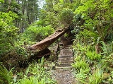
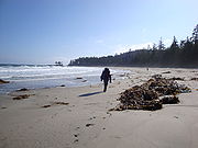
The park is known for its old growth forest
and sandy beaches. The terrain is rugged and the area is known for its heavy rain and violent storms.
The park's highest point is Mt. St. Patrick, 422 meters above sea level. The park's largest lake is Eric Lake, at 44 hectares.
Most of the park is in the Nahwitti Lowland, a subunit of the Hecate Depression, part of the Coastal Trough.
The former settlement of Cape Scott, which was founded by Danish-Canadian
immigrants, is located within the park at 50°47′00"N 128°20′00"W at the head of Hansen Lagoon. Another related settlement in the area is Strandby, named after a coastal village in Denmark and located facing Shuttleworth Bight at 50°50′15"N 128°08′20"W.
First Nations created trails through the area that includes the park, using these trails for trade, to harvest resources, and to visit locations that were considered sacred. Three First Nations reserves
are within the park, including the former village of Nahwitti.
In 1786, the area was given the name "Cape Scott" in honour of David Scott, a merchant from Bombay who had backed a trading voyage to the cape. From 1897 until 1910, Danish
settlers tried to establish a fishing community near San Josef Bay. Due to the harsh climate and lack of governmental support, the community failed and most settlers left the area. Following that, another attempt was made at Hansen Lagoon, similarly failing by 1917. Alfred Spencer, the last resident, left in 1956.
Some artifacts can still be seen in the park, including a three-metre-tall granite tombstone, several corduroy road
s, many ruins (that look like anonymous mossy mounds), and rusty farming implements.
A lighthouse
was built on the cape in 1960 and is still in operation. Despite its remote location, it is still staffed by lighthouse keepers, and is one of the few lighthouses that has not been automated. The light-house is operated by the Canadian Coast Guard and is technically outside of the park boundary, although there is a trail to the lighthouse that is usually open to visitors.
The park is a popular destination for backpackers
during the less rainy summer season. A logging road connects the towns of Port Hardy and Holberg
to the southern end of the park. The rest of the park is accessible only by foot, helicopter, or boat. A popular backpacking trip is to hike the 16.8 km Cape Scott Trail to Nels Bight, which typically requires 4–7 hours each way and is rated as easy/moderate in difficulty. It is mostly flat, but is often very muddy. Much of the trail consists of wooden boardwalk. The 43.1 km North Coast Trail
, which opened in 2008, is an extension to the Cape Scott Trail. It has some very difficult sections in the east, and more moderate terrain in the west.
There are multiple campsites with pit toilet
s, metal food caches, and wooden tent platforms along the original Cape Scott trail and the North Coast Trail. For day hikers looking for a shorter trail (less than an hour each way), there is a path out to the beach at San Josef Bay.
Provincial park
A provincial park is a park under the management of a provincial or territorial government in Canada.While provincial parks are not the same as national parks, their workings are very similar...
located at the cape of the same name, which is the northwestern tip of Vancouver Island
Vancouver Island
Vancouver Island is a large island in British Columbia, Canada. It is one of several North American locations named after George Vancouver, the British Royal Navy officer who explored the Pacific Northwest coast of North America between 1791 and 1794...
, British Columbia
British Columbia
British Columbia is the westernmost of Canada's provinces and is known for its natural beauty, as reflected in its Latin motto, Splendor sine occasu . Its name was chosen by Queen Victoria in 1858...
, Canada
Canada
Canada is a North American country consisting of ten provinces and three territories. Located in the northern part of the continent, it extends from the Atlantic Ocean in the east to the Pacific Ocean in the west, and northward into the Arctic Ocean...
. First established in 1973 with c.37.2 acres (150,543.2 m²) of area, later boundary revisions form an area of 22,290 ha. Lanz and Cox Islands Provincial Park
Lanz and Cox Islands Provincial Park
Lanz and Cox Islands Provincial Park, formerly Scott Islands Marine Provincial Park is a provincial park in British Columbia, Canada, located off Cape Scott on Northern Vancouver Island.-References:...
, formerly Scott Islands Marine Provincial Park, is offshore, to the northwest of Cape Scott.
Geography
Cape Scott, which has had a lighthouse since 1960 and is the northwestern extremity of Vancouver Island, is located at 50°47′00"N 128°26′00"W, is outside the provincial park and is on Department of National DefenceDepartment of National Defence (Canada)
The Department of National Defence , frequently referred to by its acronym DND, is the department within the government of Canada with responsibility for all matters concerning the defence of Canada...
property.
The park is known for its old growth forest
Old growth forest
An old-growth forest is a forest that has attained great age , and thereby exhibits unique ecological features. An old growth forest has also usually reached a climax community...
and sandy beaches. The terrain is rugged and the area is known for its heavy rain and violent storms.
The park's highest point is Mt. St. Patrick, 422 meters above sea level. The park's largest lake is Eric Lake, at 44 hectares.
Most of the park is in the Nahwitti Lowland, a subunit of the Hecate Depression, part of the Coastal Trough.
The former settlement of Cape Scott, which was founded by Danish-Canadian
Danish-Canadian
According to the 2006 Census, there were 200,035 Canadians with Danish background, 17,650 of whom were born in Denmark . Canada became an important destination for the Danes during the post war period. At one point, a Canadian immigration office was to be set up in Copenhagen...
immigrants, is located within the park at 50°47′00"N 128°20′00"W at the head of Hansen Lagoon. Another related settlement in the area is Strandby, named after a coastal village in Denmark and located facing Shuttleworth Bight at 50°50′15"N 128°08′20"W.
History
The Kwakwaka'wakwKwakwaka'wakw
The Kwakwaka'wakw are an Indigenous group of First Nations peoples, numbering about 5,500, who live in British Columbia on northern Vancouver Island and the adjoining mainland and islands.Kwakwaka'wakw translates as "Those who speak Kwak'wala", describing the collective nations within the area that...
First Nations created trails through the area that includes the park, using these trails for trade, to harvest resources, and to visit locations that were considered sacred. Three First Nations reserves
Indian reserve
In Canada, an Indian reserve is specified by the Indian Act as a "tract of land, the legal title to which is vested in Her Majesty, that has been set apart by Her Majesty for the use and benefit of a band." The Act also specifies that land reserved for the use and benefit of a band which is not...
are within the park, including the former village of Nahwitti.
In 1786, the area was given the name "Cape Scott" in honour of David Scott, a merchant from Bombay who had backed a trading voyage to the cape. From 1897 until 1910, Danish
Denmark
Denmark is a Scandinavian country in Northern Europe. The countries of Denmark and Greenland, as well as the Faroe Islands, constitute the Kingdom of Denmark . It is the southernmost of the Nordic countries, southwest of Sweden and south of Norway, and bordered to the south by Germany. Denmark...
settlers tried to establish a fishing community near San Josef Bay. Due to the harsh climate and lack of governmental support, the community failed and most settlers left the area. Following that, another attempt was made at Hansen Lagoon, similarly failing by 1917. Alfred Spencer, the last resident, left in 1956.
Some artifacts can still be seen in the park, including a three-metre-tall granite tombstone, several corduroy road
Corduroy road
A corduroy road or log road is a type of road made by placing sand-covered logs perpendicular to the direction of the road over a low or swampy area....
s, many ruins (that look like anonymous mossy mounds), and rusty farming implements.
A lighthouse
Lighthouse
A lighthouse is a tower, building, or other type of structure designed to emit light from a system of lamps and lenses or, in older times, from a fire, and used as an aid to navigation for maritime pilots at sea or on inland waterways....
was built on the cape in 1960 and is still in operation. Despite its remote location, it is still staffed by lighthouse keepers, and is one of the few lighthouses that has not been automated. The light-house is operated by the Canadian Coast Guard and is technically outside of the park boundary, although there is a trail to the lighthouse that is usually open to visitors.
Recreation
The park is a popular destination for backpackers
Backpacking (wilderness)
Backpacking combines the activities of hiking and camping for an overnight stay in backcountry wilderness...
during the less rainy summer season. A logging road connects the towns of Port Hardy and Holberg
Holberg, British Columbia
Holberg is a small settlement on northern Vancouver Island, British Columbia, Canada. The community was established in the early 1900s by Danish settlers who named their new home in honour of Baron Ludwig Holberg....
to the southern end of the park. The rest of the park is accessible only by foot, helicopter, or boat. A popular backpacking trip is to hike the 16.8 km Cape Scott Trail to Nels Bight, which typically requires 4–7 hours each way and is rated as easy/moderate in difficulty. It is mostly flat, but is often very muddy. Much of the trail consists of wooden boardwalk. The 43.1 km North Coast Trail
North Coast Trail
The North Coast Trail is a 43.1 km wilderness hiking trail in Cape Scott Provincial Park on northern Vancouver Island, British Columbia, Canada.- The Trail :...
, which opened in 2008, is an extension to the Cape Scott Trail. It has some very difficult sections in the east, and more moderate terrain in the west.
There are multiple campsites with pit toilet
Pit toilet
A pit toilet is a dry toilet system which collects human excrement in a large container and range from a simple slit trench to more elaborate systems with ventilation. They are more often used in rural and wilderness areas as well as in much of the developing world...
s, metal food caches, and wooden tent platforms along the original Cape Scott trail and the North Coast Trail. For day hikers looking for a shorter trail (less than an hour each way), there is a path out to the beach at San Josef Bay.
See also
- List of British Columbia Provincial Parks
- List of Canadian provincial parks
- Ronning GardensRonning GardensRonning Gardens, located in a remote location near the northwest tip of Vancouver Island, British Columbia, Canada, were established by Norwegian settler Bernt Ronning around 1910...
External links
- Cape Scott Provincial Park at BC Parks
- Official park map (PDF)
- http://www.portalice.ca/capescott.htm