

Aggradation
Encyclopedia
Geology
Geology is the science comprising the study of solid Earth, the rocks of which it is composed, and the processes by which it evolves. Geology gives insight into the history of the Earth, as it provides the primary evidence for plate tectonics, the evolutionary history of life, and past climates...
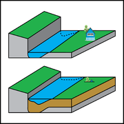
for the increase in land elevation due to the deposition
Deposition (geology)
Deposition is the geological process by which material is added to a landform or land mass. Fluids such as wind and water, as well as sediment flowing via gravity, transport previously eroded sediment, which, at the loss of enough kinetic energy in the fluid, is deposited, building up layers of...
of sediment. Aggradation occurs in areas in which the supply of sediment is greater than the amount of material that the system is able to transport
Sediment transport
Sediment transport is the movement of solid particles , typically due to a combination of the force of gravity acting on the sediment, and/or the movement of the fluid in which the sediment is entrained...
. The mass balance between sediment being transported and sediment in the bed is described by the Exner equation
Exner equation
The Exner equation is a statement of conservation of mass that applies to sediment in a fluvial system such as a river. It was developed by the Austrian meteorologist and sedimentologist Felix Maria Exner, from whom it derives its name.-The equation:...
.
Typical aggradational environments include lowland alluvial rivers, river delta
River delta
A delta is a landform that is formed at the mouth of a river where that river flows into an ocean, sea, estuary, lake, reservoir, flat arid area, or another river. Deltas are formed from the deposition of the sediment carried by the river as the flow leaves the mouth of the river...
s, and alluvial fan
Alluvial fan
An alluvial fan is a fan-shaped deposit formed where a fast flowing stream flattens, slows, and spreads typically at the exit of a canyon onto a flatter plain. A convergence of neighboring alluvial fans into a single apron of deposits against a slope is called a bajada, or compound alluvial...
s. Aggradational environments are often undergoing slow subsidence
Subsidence
Subsidence is the motion of a surface as it shifts downward relative to a datum such as sea-level. The opposite of subsidence is uplift, which results in an increase in elevation...
which balances the increase in land surface elevation due to aggradation. After millions of years, an aggradational environment will become a sedimentary basin
Sedimentary basin
The term sedimentary basin is used to refer to any geographical feature exhibiting subsidence and consequent infilling by sedimentation. As the sediments are buried, they are subjected to increasing pressure and begin the process of lithification...
, which contains the deposited sediment, including paleochannels and ancient floodplain
Floodplain
A floodplain, or flood plain, is a flat or nearly flat land adjacent a stream or river that stretches from the banks of its channel to the base of the enclosing valley walls and experiences flooding during periods of high discharge...
s.
Aggradation can be caused by changes in climate
Climate
Climate encompasses the statistics of temperature, humidity, atmospheric pressure, wind, rainfall, atmospheric particle count and other meteorological elemental measurements in a given region over long periods...
, land use
Land use
Land use is the human use of land. Land use involves the management and modification of natural environment or wilderness into built environment such as fields, pastures, and settlements. It has also been defined as "the arrangements, activities and inputs people undertake in a certain land cover...
, and geologic activity, such as volcanic eruption, earthquake
Earthquake
An earthquake is the result of a sudden release of energy in the Earth's crust that creates seismic waves. The seismicity, seismism or seismic activity of an area refers to the frequency, type and size of earthquakes experienced over a period of time...
s, and faulting. For example, volcanic eruptions may lead to rivers carrying more sediment than the flow can transport: this leads to the burial of the old channel and its floodplain
Floodplain
A floodplain, or flood plain, is a flat or nearly flat land adjacent a stream or river that stretches from the banks of its channel to the base of the enclosing valley walls and experiences flooding during periods of high discharge...
. In another example, the quantity of sediment entering a river channel may increase when climate becomes drier. The increase in sediment is caused by a decrease in soil binding that results from plant growth being suppressed. The drier conditions cause river flow to decrease at the same time as sediment is being supplied in greater quantities, resulting in the river becoming choked with sediment.
In 2009, a report by researchers from the University of Colorado at Boulder
University of Colorado at Boulder
The University of Colorado Boulder is a public research university located in Boulder, Colorado...
in the journal Nature Geoscience
Nature Geoscience
Nature Geoscience is a monthly, peer reviewed, scientific journal published by Nature Publishing Group. The Chief Editor is Heike Langenberg. The first issue was published in January 2008.-Scope:...
said that reduced aggradation was contributing to an increased risk of flooding in many river delta
River delta
A delta is a landform that is formed at the mouth of a river where that river flows into an ocean, sea, estuary, lake, reservoir, flat arid area, or another river. Deltas are formed from the deposition of the sediment carried by the river as the flow leaves the mouth of the river...
s.
See also
- Sediment transportSediment transportSediment transport is the movement of solid particles , typically due to a combination of the force of gravity acting on the sediment, and/or the movement of the fluid in which the sediment is entrained...
- Exner equationExner equationThe Exner equation is a statement of conservation of mass that applies to sediment in a fluvial system such as a river. It was developed by the Austrian meteorologist and sedimentologist Felix Maria Exner, from whom it derives its name.-The equation:...
- River deltaRiver deltaA delta is a landform that is formed at the mouth of a river where that river flows into an ocean, sea, estuary, lake, reservoir, flat arid area, or another river. Deltas are formed from the deposition of the sediment carried by the river as the flow leaves the mouth of the river...
- ProgradationProgradationIn sedimentary geology and geomorphology, the term progradation refers to the growth of a river delta farther out into the sea over time. This occurs when the mass balance of sediment into the delta is such that the volume of incoming sediment is greater than the volume of the delta that is lost...
- Alluvial fanAlluvial fanAn alluvial fan is a fan-shaped deposit formed where a fast flowing stream flattens, slows, and spreads typically at the exit of a canyon onto a flatter plain. A convergence of neighboring alluvial fans into a single apron of deposits against a slope is called a bajada, or compound alluvial...
- Sedimentary basinSedimentary basinThe term sedimentary basin is used to refer to any geographical feature exhibiting subsidence and consequent infilling by sedimentation. As the sediments are buried, they are subjected to increasing pressure and begin the process of lithification...
- Avulsion (river)Avulsion (river)In sedimentary geology and fluvial geomorphology, avulsion is the rapid abandonment of a river channel and the formation of a new river channel. Avulsions occur as a result of channel slopes that are much lower than the slope that the river could travel if it took a new course.-Deltaic and...