

Redcliffe-Maud Report
Encyclopedia
Royal Commission
In Commonwealth realms and other monarchies a Royal Commission is a major ad-hoc formal public inquiry into a defined issue. They have been held in various countries such as the United Kingdom, Australia, Canada, New Zealand, and Saudi Arabia...
on Local Government in England
England
England is a country that is part of the United Kingdom. It shares land borders with Scotland to the north and Wales to the west; the Irish Sea is to the north west, the Celtic Sea to the south west, with the North Sea to the east and the English Channel to the south separating it from continental...
1966–1969 under the chairmanship of Lord Redcliffe-Maud.
Terms of reference and membership
The commission was appointed on 7 June 1966, with the following terms of reference:"...to consider the structure of Local Government in England, outside Greater London, in relation to its existing functions; and to make recommendations for authorities and boundaries, and for functions and their division, having regard to the size and character of areas in which these can be most effectively exercised and the need to sustain a viable system of local democracy; and to report."
The members of the Commission were Redcliffe-Maud (chair), John Eveleigh Bolton (vice-chair), Derek Senior
Derek Senior
Derek Senior was a British freelance writer principally known for being a member of the Royal Commission on Local Government in England, chaired by Lord Redcliffe-Maud.-Early career:...
, Sir James William Francis Hill
Francis Hill
Sir James William Francis Hill CBE was a leading historian of Lincoln and Lincolnshire, and the 3rd Chancellor of the University of Nottingham. He also served as a Councillor, Alderman and Mayor of Lincoln....
, Victor Grayson Hardie Feather
Vic Feather
Victor Grayson Hardie Feather, Baron Feather was General Secretary of the Trade Union Congress in Great Britain from 1969 to 1973....
, Arthur Hedley Marshall, Peter Mursell, John Laurence Longland, Reginald Charles Wallis, Thomas Dan Smith
T. Dan Smith
Thomas Daniel Smith was a British politician who was Leader of Newcastle upon Tyne City Council from 1960 to 1965. He was a prominent figure in the Labour Party in the north east of England, such that he was nicknamed 'Mr Newcastle'...
and Dame Evelyn Adelaide Sharp
Evelyn Sharp, Baroness Sharp
Evelyn Adelaide Sharp, Baroness Sharp of Hornsey was a British civil servant and the first women to hold the position of Permanent Secretary, the most senior civil servant in a Ministry.-Early life:...
.
The report
County
A county is a jurisdiction of local government in certain modern nations. Historically in mainland Europe, the original French term, comté, and its equivalents in other languages denoted a jurisdiction under the sovereignty of a count A county is a jurisdiction of local government in certain...
, county borough
County borough
County borough is a term introduced in 1889 in the United Kingdom of Great Britain and Ireland , to refer to a borough or a city independent of county council control. They were abolished by the Local Government Act 1972 in England and Wales, but continue in use for lieutenancy and shrievalty in...
, borough
Borough
A borough is an administrative division in various countries. In principle, the term borough designates a self-governing township although, in practice, official use of the term varies widely....
, urban district
Urban district
In the England, Wales and Ireland, an urban district was a type of local government district that covered an urbanised area. Urban districts had an elected Urban District Council , which shared local government responsibilities with a county council....
and rural district
Rural district
Rural districts were a type of local government area – now superseded – established at the end of the 19th century in England, Wales, and Ireland for the administration of predominantly rural areas at a level lower than that of the administrative counties.-England and Wales:In England...
councils, which had been created at the end of the 19th century, and replacing them with new unitary authorities. These new unitary authorities were largely based on major towns, which acted as regional employment, commercial, social and recreational centres and took into account local transport infrastructure and travel patterns.
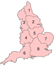
There were to be 58 new unitary authorities and three metropolitan areas (Merseyside
Merseyside
Merseyside is a metropolitan county in North West England, with a population of 1,365,900. It encompasses the metropolitan area centred on both banks of the lower reaches of the Mersey Estuary, and comprises five metropolitan boroughs: Knowsley, St Helens, Sefton, Wirral, and the city of Liverpool...
, South East Lancashire/North East Cheshire
Greater Manchester
Greater Manchester is a metropolitan county in North West England, with a population of 2.6 million. It encompasses one of the largest metropolitan areas in the United Kingdom and comprises ten metropolitan boroughs: Bolton, Bury, Oldham, Rochdale, Stockport, Tameside, Trafford, Wigan, and the...
or 'Selnec' and West Midlands), which were to be sub-divided into lower tier metropolitan districts. These new authorities, along with Greater London
Greater London
Greater London is the top-level administrative division of England covering London. It was created in 1965 and spans the City of London, including Middle Temple and Inner Temple, and the 32 London boroughs. This territory is coterminate with the London Government Office Region and the London...
were to be grouped into eight provinces, each with its own provincial council.
Division of functions
In arriving at their recommendations, the commissioners were guided by a number of principles which they had themselves devised. These included:- Town and country are interdependent, therefore the separate administration of urban areas and their rural hinterlands should cease.
- "Physical environment services" should be in the hands of a single authority. Examples of these services included planning and transport. In order to provide these wide area services, the authority should have boundaries that reflected geographical patterns of population and movement and provided a coherent area of administration.
- "Personal services" should likewise be administered by a single council. These included education, social services, health and housing. The optimum population range over which to provide these services was 250,000 to 1,000,000.
- Wherever possible, both types of services should be in the hands of a single unitary authority.
- Areas for the new authorities should be capable of being effectively and democratically administered by a single council.
Accordingly the different categories of council would have the following powers and responsibilities:
- Provincial councils: Drawing up of strategic development plans. They were to take over the functions of the existing Regional Economic Planning Councils.
- Unitary area councils: Both physical environment and personal services
- Metropolitan area councils: Planning, transport and general housing policy.
- Metropolitan district councils: Education and personal social services.
Local councils
It had originally been envisaged that parish councils should also be abolished, but the Secretary of the National Association of Parish Councils (NACP), Charles Arnold-BakerCharles Arnold-Baker
Charles Arnold-Baker, OBE, born Wolfgang Charles Werner von Blumenthal was an English barrister , an academic and a historian. He was the author of the Companion to British History...
, convinced the Commission that they should be preserved.
Derek Senior's Memorandum of Dissent
The Commission was nearly unanimous, with some reservations as to the exact geographic details. One member of the Commission, Derek Senior, dissented entirely from the proposals, and put forward his own in a Memorandum of Dissent (Cmnd. 4040-I), which was slightly larger than the Report itself. He would have preferred a two-tier system, with 35 city-regions of varying size, along with 148 districts. These were to be further grouped into five provinces. At a lower level, there would be 'common councils', roughly equivalent to civil parish councils, which would also cover communities within large towns; special arrangements were to be made for the area surrounding Berwick-upon-TweedBerwick-upon-Tweed
Berwick-upon-Tweed or simply Berwick is a town in the county of Northumberland and is the northernmost town in England, on the east coast at the mouth of the River Tweed. It is situated 2.5 miles south of the Scottish border....
. These proposals effectively ignored traditional boundaries, to a much greater extent than the Report itself did.
Reaction
Immediately after the report was published, Prime Minister Harold WilsonHarold Wilson
James Harold Wilson, Baron Wilson of Rievaulx, KG, OBE, FRS, FSS, PC was a British Labour Member of Parliament, Leader of the Labour Party. He was twice Prime Minister of the United Kingdom during the 1960s and 1970s, winning four general elections, including a minority government after the...
said that he accepted the recommendations "in principle" and committed the government to "press ahead quickly" on the legislation necessary to implement it, later clarifying that legislation would probably follow in the 1970–71 or 1971–72 Parliamentary session. The Labour Party
Labour Party (UK)
The Labour Party is a centre-left democratic socialist party in the United Kingdom. It surpassed the Liberal Party in general elections during the early 1920s, forming minority governments under Ramsay MacDonald in 1924 and 1929-1931. The party was in a wartime coalition from 1940 to 1945, after...
Government issued a White Paper entitled "Reform of Local Government in England" (Cmnd
Command paper
A command paper is a document issued by the British government and presented to Parliament. White papers, green papers, treaties, reports from Royal Commissions and various government bodies can all be released as command papers, so-called because they are presented to Parliament formally 'By Her...
4276) in February 1970, broadly accepting the recommendations of the report. The Government had however added two new metropolitan areas: West Yorkshire (with the five Bradford/Leeds/Halifax/Huddersfield/Mid-Yorkshire unitaries as districts), and South Hampshire based on the Southampton and Portsmouth unitaries, with the Isle of Wight being a separate district.
Observers felt that the Conservative Party
Conservative Party (UK)
The Conservative Party, formally the Conservative and Unionist Party, is a centre-right political party in the United Kingdom that adheres to the philosophies of conservatism and British unionism. It is the largest political party in the UK, and is currently the largest single party in the House...
, then in opposition, had no urgency in defining their position. The shadow spokesman Peter Walker
Peter Walker, Baron Walker of Worcester
Peter Edward Walker, Baron Walker of Worcester, MBE, PC , was British politician. A member of the Conservative Party, he served in the Cabinet as the Environment Secretary , Trade and Industry Secretary , Agriculture Minister , Energy Secretary and Welsh Secretary...
did not commit himself but instead held a series of regional conferences to ascertain party grassroots opinion. Reports suggested these conferences were overwhelmingly hostile and the Conservative Party conference in 1969 passed a highly critical motion, while suggesting that some reform of local government was supported. Walker decided that a future Conservative government could not implement Redcliffe-Maud, but refused to disown the report completely.
The Rural District Councils Association was immediately opposed to the proposals which would see their members subsumed in much larger authorities. They started a national campaign with the slogan "Don't Vote for R.E. Mote" (with Mr R.E. Mote depicted as an insensitive bureaucrat), distributing material to all their members. The slogan was used on postal franking from the affected authorities. The Swale Rural District was forced to opt out of the campaign due to the similarity of "R.E. Mote" with its then-prospective candidate R.D. Moate
Roger Moate
Sir Roger Denis Moate is a Conservative politician in the United Kingdom.Moate was educated at Latymer Upper School, Hammersmith and was an insurance broker. He first stood for Parliament for the Faversham constituency at the 1966 general election, losing to Labour's Terence Boston...
. By coincidence, Moate had moved the motion opposing Redcliffe-Maud at the Conservative Party conference.
New government
When the Conservatives won the 1970 general electionUnited Kingdom general election, 1970
The United Kingdom general election of 1970 was held on 18 June 1970, and resulted in a surprise victory for the Conservative Party under leader Edward Heath, who defeated the Labour Party under Harold Wilson. The election also saw the Liberal Party and its new leader Jeremy Thorpe lose half their...
, they did so on a manifesto committed to a two-tier system in local government. In 1971 a further White Paper entitled "Local Government in England: Government Proposals for Reoganisation" (Cmnd 4584) announced its intentions, which ultimately led to the 1974 re-organisation
Local Government Act 1972
The Local Government Act 1972 is an Act of Parliament in the United Kingdom that reformed local government in England and Wales on 1 April 1974....
. Although the general plan of the Report was abandoned, many of the specific innovations were carried over, such as the plan to associate Slough
Slough
Slough is a borough and unitary authority within the ceremonial county of Royal Berkshire, England. The town straddles the A4 Bath Road and the Great Western Main Line, west of central London...
with Berkshire
Berkshire
Berkshire is a historic county in the South of England. It is also often referred to as the Royal County of Berkshire because of the presence of the royal residence of Windsor Castle in the county; this usage, which dates to the 19th century at least, was recognised by the Queen in 1957, and...
, and Bournemouth
Bournemouth
Bournemouth is a large coastal resort town in the ceremonial county of Dorset, England. According to the 2001 Census the town has a population of 163,444, making it the largest settlement in Dorset. It is also the largest settlement between Southampton and Plymouth...
with Dorset
Dorset
Dorset , is a county in South West England on the English Channel coast. The county town is Dorchester which is situated in the south. The Hampshire towns of Bournemouth and Christchurch joined the county with the reorganisation of local government in 1974...
.
Aftermath
In the actual 1974 re-organisation, the three metropolitan areas became metropolitan countiesMetropolitan county
The metropolitan counties are a type of county-level administrative division of England. There are six metropolitan counties, which each cover large urban areas, typically with populations of 1.2 to 2.8 million...
, though their area was greatly reduced. A further three were added, covering the Leeds
Leeds
Leeds is a city and metropolitan borough in West Yorkshire, England. In 2001 Leeds' main urban subdivision had a population of 443,247, while the entire city has a population of 798,800 , making it the 30th-most populous city in the European Union.Leeds is the cultural, financial and commercial...
/Bradford
Bradford
Bradford lies at the heart of the City of Bradford, a metropolitan borough of West Yorkshire, in Northern England. It is situated in the foothills of the Pennines, west of Leeds, and northwest of Wakefield. Bradford became a municipal borough in 1847, and received its charter as a city in 1897...
area (West Yorkshire
West Yorkshire
West Yorkshire is a metropolitan county within the Yorkshire and the Humber region of England with a population of 2.2 million. West Yorkshire came into existence as a metropolitan county in 1974 after the passage of the Local Government Act 1972....
), the Sheffield
Sheffield
Sheffield is a city and metropolitan borough of South Yorkshire, England. Its name derives from the River Sheaf, which runs through the city. Historically a part of the West Riding of Yorkshire, and with some of its southern suburbs annexed from Derbyshire, the city has grown from its largely...
/Rotherham
Rotherham
Rotherham is a town in South Yorkshire, England. It lies on the River Don, at its confluence with the River Rother, between Sheffield and Doncaster. Rotherham, at from Sheffield City Centre, is surrounded by several smaller settlements, which together form the wider Metropolitan Borough of...
area (South Yorkshire
South Yorkshire
South Yorkshire is a metropolitan county in the Yorkshire and the Humber region of England. It has a population of 1.29 million. It consists of four metropolitan boroughs: Barnsley, Doncaster, Rotherham, and City of Sheffield...
) and the Tyneside
Tyneside
Tyneside is a conurbation in North East England, defined by the Office of National Statistics, which is home to over 80% of the population of Tyne and Wear. It includes the city of Newcastle upon Tyne and the Metropolitan Boroughs of Gateshead, North Tyneside and South Tyneside — all settlements on...
area (Tyne and Wear
Tyne and Wear
Tyne and Wear is a metropolitan county in north east England around the mouths of the Rivers Tyne and Wear. It came into existence as a metropolitan county in 1974 after the passage of the Local Government Act 1972...
). The concept of authorities based around Bristol
Bristol
Bristol is a city, unitary authority area and ceremonial county in South West England, with an estimated population of 433,100 for the unitary authority in 2009, and a surrounding Larger Urban Zone with an estimated 1,070,000 residents in 2007...
(Avon), and Teesside
Teesside
Teesside is the name given to the conurbation in the north east of England made up of the towns of Middlesbrough, Stockton-on-Tees, Redcar, Billingham and surrounding settlements near the River Tees. It was also the name of a local government district between 1968 and 1974—the County Borough of...
(Cleveland) was also retained. In most areas though, the 1974 system was far more conservative and retained more traditional boundaries.
The situation of wholly two-tier government did not last. The county councils for the metropolitan counties were abolished in 1986 by Margaret Thatcher
Margaret Thatcher
Margaret Hilda Thatcher, Baroness Thatcher, was Prime Minister of the United Kingdom from 1979 to 1990...
's government, making the metropolitan boroughs into unitary authorities. A further set of reforms in the 1990s led to the re-establishment of many old county boroughs as unitary authorities, along with other areas.
In 2004 the Government put forward a proposal to introduce directly-elected regional assemblies
Regional Assemblies in England
The Regional Assemblies of England were a group of indirectly elected regional bodies established originally under the name Regional Chambers by the Regional Development Agencies Act 1998. They were abolished on 31 March 2010 and replaced by Local Authority Leaders’ Boards...
in the three regions
Regions of England
In England, the region is the highest tier of sub-national division used by central Government. Between 1994 and 2011, the nine regions had an administrative role in the implementation of UK Government policy, and as the areas covered by elected bodies...
of Northern England
Northern England
Northern England, also known as the North of England, the North or the North Country, is a cultural region of England. It is not an official government region, but rather an informal amalgamation of counties. The southern extent of the region is roughly the River Trent, while the North is bordered...
, should referendums
Northern England referendums, 2004
The Northern England devolution referendums were referendums starting with the North East region of England, in the United Kingdom, on 4 November 2004. Dubbed by the government the Great North Vote, the referendum proposed that the region should have an elected regional assembly...
produce a 'yes' vote (in the event the first region voted 'no' overwhelmingly, and the other referendums were abandoned). The regional boundaries proposed were very similar to the three northern Redcliffe-Maud provinces. Associated with this reform would have been a move to wholly unitary local government in the affected regions. In the area of Cumbria
Cumbria
Cumbria , is a non-metropolitan county in North West England. The county and Cumbria County Council, its local authority, came into existence in 1974 after the passage of the Local Government Act 1972. Cumbria's largest settlement and county town is Carlisle. It consists of six districts, and in...
and Lancashire
Lancashire
Lancashire is a non-metropolitan county of historic origin in the North West of England. It takes its name from the city of Lancaster, and is sometimes known as the County of Lancaster. Although Lancaster is still considered to be the county town, Lancashire County Council is based in Preston...
, the proposals bear a striking resemblance to the ones in the Report.
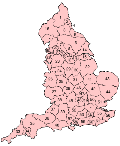
Proposed Unitary Areas
| Province | Number | Unitary authority | Approximate extent |
|---|---|---|---|
| North East | 1 | Northumberland | non-metropolitan Northumberland Northumberland Northumberland is the northernmost ceremonial county and a unitary district in North East England. For Eurostat purposes Northumberland is a NUTS 3 region and is one of three boroughs or unitary districts that comprise the "Northumberland and Tyne and Wear" NUTS 2 region... |
| 2 | Tyneside | Tyne and Wear Tyne and Wear Tyne and Wear is a metropolitan county in north east England around the mouths of the Rivers Tyne and Wear. It came into existence as a metropolitan county in 1974 after the passage of the Local Government Act 1972... minus Sunderland City of Sunderland The City of Sunderland is a local government district of Tyne and Wear, in North East England, with the status of a city and metropolitan borough... |
|
| 3 | Durham | ceremonial County Durham County Durham County Durham is a ceremonial county and unitary district in north east England. The county town is Durham. The largest settlement in the ceremonial county is the town of Darlington... minus Easington Easington (district) Easington was, from 1974 to 2009, a local government district in eastern County Durham, England. It contained the settlements of Easington, Seaham, Peterlee, Murton, Horden, Blackhall, Wingate and Castle Eden... |
|
| 4 | Sunderland & East Durham | Sunderland City of Sunderland The City of Sunderland is a local government district of Tyne and Wear, in North East England, with the status of a city and metropolitan borough... and Easington Easington (district) Easington was, from 1974 to 2009, a local government district in eastern County Durham, England. It contained the settlements of Easington, Seaham, Peterlee, Murton, Horden, Blackhall, Wingate and Castle Eden... |
|
| 5 | Teesside | former non-metropolitan county of Cleveland Cleveland, England Cleveland is an area in the north east of England. Its name means literally "cliff-land", referring to its hilly southern areas, which rise to nearly... plus Whitby Whitby Whitby is a seaside town, port and civil parish in the Scarborough borough of North Yorkshire, England. Situated on the east coast of Yorkshire at the mouth of the River Esk, Whitby has a combined maritime, mineral and tourist heritage, and is home to the ruins of Whitby Abbey where Caedmon, the... etc. |
|
| Yorkshire | 6 | York | non-metropolitan North Yorkshire North Yorkshire North Yorkshire is a non-metropolitan or shire county located in the Yorkshire and the Humber region of England, and a ceremonial county primarily in that region but partly in North East England. Created in 1974 by the Local Government Act 1972 it covers an area of , making it the largest... and York York York is a walled city, situated at the confluence of the Rivers Ouse and Foss in North Yorkshire, England. The city has a rich heritage and has provided the backdrop to major political events throughout much of its two millennia of existence... minus Harrogate Harrogate (borough) Harrogate is a local government district and borough of North Yorkshire, England. Its council is based in the town of Harrogate but it also includes surrounding towns and villages... , Craven, Whitby Whitby Whitby is a seaside town, port and civil parish in the Scarborough borough of North Yorkshire, England. Situated on the east coast of Yorkshire at the mouth of the River Esk, Whitby has a combined maritime, mineral and tourist heritage, and is home to the ruins of Whitby Abbey where Caedmon, the... |
| 7 | Bradford | Bradford City of Bradford The City of Bradford is a local government district of West Yorkshire, England with the status of a city and metropolitan borough. It is named after its largest settlement, Bradford, but covers a far larger area which includes the towns of Keighley, Shipley, Bingley, Ilkley, Haworth, Silsden and... , Craven |
|
| 8 | Leeds | Leeds City of Leeds The City of Leeds is a local government district of West Yorkshire, England, governed by Leeds City Council, with the status of a city and metropolitan borough. The metropolitan district includes Leeds and the towns of Farsley, Garforth, Guiseley, Horsforth, Morley, Otley, Pudsey, Rothwell,... , Harrogate Harrogate (borough) Harrogate is a local government district and borough of North Yorkshire, England. Its council is based in the town of Harrogate but it also includes surrounding towns and villages... |
|
| 9 | Halifax | Calderdale Calderdale The Metropolitan Borough of Calderdale is a metropolitan borough of West Yorkshire, England, through which the upper part of the River Calder flows, and from which it takes its name... |
|
| 10 | Huddersfield | Kirklees | |
| 11 | Mid Yorkshire | Wakefield City of Wakefield The City of Wakefield is a local government district of West Yorkshire, England, with the status of a city and metropolitan borough. Wakefield is the district's administrative centre. The district includes the "Five Towns" of Normanton, Pontefract, Featherstone, Castleford and Knottingley. Other... |
|
| 12 | Sheffield & South Yorkshire | Sheffield, Rotherham | |
| 13 | Doncaster | Doncaster | |
| 14 | North Humberside | ceremonial county of East Riding of Yorkshire East Riding of Yorkshire The East Riding of Yorkshire, or simply East Yorkshire, is a local government district with unitary authority status, and a ceremonial county of England. For ceremonial purposes the county also includes the city of Kingston upon Hull, which is a separate unitary authority... , small part of North Yorkshire North Yorkshire North Yorkshire is a non-metropolitan or shire county located in the Yorkshire and the Humber region of England, and a ceremonial county primarily in that region but partly in North East England. Created in 1974 by the Local Government Act 1972 it covers an area of , making it the largest... |
|
| 15 | South Humberside | North Lincolnshire North Lincolnshire North Lincolnshire is a unitary authority area in the region of Yorkshire and the Humber in England. For ceremonial purposes it is part of Lincolnshire.... and North East Lincolnshire North East Lincolnshire North East Lincolnshire is a unitary authority in the Yorkshire and the Humber region of England, bordering the unitary authority of North Lincolnshire and the administrative county of Lincolnshire... |
|
| North West | 16 | Cumberland & North Westmorland | Carlisle City of Carlisle The City of Carlisle is a local government district of Cumbria, England, with the status of a city and non-metropolitan district. It is named after its largest settlement, Carlisle, but covers a far larger area which includes the towns of Brampton and Longtown, as well as outlying villages... , former Cumberland Cumberland Cumberland is a historic county of North West England, on the border with Scotland, from the 12th century until 1974. It formed an administrative county from 1889 to 1974 and now forms part of Cumbria.... , area around Appleby in Westmorland Westmorland Westmorland is an area of North West England and one of the 39 historic counties of England. It formed an administrative county from 1889 to 1974, after which the entirety of the county was absorbed into the new county of Cumbria.-Early history:... |
| 17 | Furness & North Lancashire | Barrow-in-Furness Barrow-in-Furness (borough) Barrow-in-Furness is a local government district with borough status in Cumbria, England. It is named after its main town, Barrow-in-Furness. Other settlements include Dalton-in-Furness, Roose and Askam-in-Furness. It is the smallest borough in the county, but is the most densely populated, with... , South Lakeland South Lakeland South Lakeland is a local government district in Cumbria, England. Its council is based in Kendal. It includes much of the Lake District.The district was created on 1 April 1974 under the Local Government Act 1972... and Lancaster |
|
| 18 | The Fylde | Blackpool Blackpool Blackpool is a borough, seaside town, and unitary authority area of Lancashire, in North West England. It is situated along England's west coast by the Irish Sea, between the Ribble and Wyre estuaries, northwest of Preston, north of Liverpool, and northwest of Manchester... , Fylde, Wyre Wyre Wyre is a local government district with borough status in Lancashire, England. Its council is based in Poulton-le-Fylde.The district is named after the River Wyre, which runs through the district... |
|
| 19 | Preston-Leyland-Chorley | Preston City of Preston, Lancashire The City of Preston is a city and non-metropolitan district in Lancashire, England. It is located on the north bank of the River Ribble, and was granted city status in 2002, becoming England's 50th city in the 50th year of Queen Elizabeth II's reign... , South Ribble South Ribble South Ribble is a non-metropolitan district and borough of Lancashire, England. Its council is based in Leyland.In May 2007, the council was officially declared "Excellent" by the Audit Commission, gaining its place among the best 5 district councils in the country,-Overview:On 4 October 2007, a... , Chorley Chorley Chorley is a market town in Lancashire, in North West England. It is the largest settlement in the Borough of Chorley. The town's wealth came principally from the cotton industry... |
|
| 20 | Blackburn | Blackburn with Darwen, Hyndburn Hyndburn Hyndburn is a local government district with borough status in Lancashire, England. Its council is based in Accrington. The district is named after the River Hyndburn.... , Ribble Valley Ribble Valley Ribble Valley is a local government district with borough status within the non-metropolitan county of Lancashire, England. Its council is based in Clitheroe. Other places include Whalley, Longridge and Ribchester. The area is so called due to the River Ribble which flows in its final stages... |
|
| 21 | Burnley | Burnley Burnley (borough) Burnley is a local government district of Lancashire, England, with the status of a non-metropolitan district and borough. It has an area of and a population of , and is named for its largest town, Burnley. The borough is bounded by Hyndburn, Ribble Valley, Pendle, Rossendale — all in Lancashire... , Pendle Pendle Pendle is a local government district and borough of Lancashire, England. It adjoins the Lancashire boroughs of Burnley and Ribble Valley, the North Yorkshire district of Craven and the West Yorkshire districts of Calderdale and the City of Bradford... , Rossendale Rossendale Rossendale is a local government district with borough status. It is made up of a number of small former mill towns in Lancashire, England centered around the valley of the River Irwell in the industrial North West... |
|
| 22 | Merseyside metropolitan area | see below | |
| 23 | Selnec metropolitan area | see below | |
| West Midlands | 24 | Stoke & North Staffordshire | Stoke-on-Trent Stoke-on-Trent Stoke-on-Trent , also called The Potteries is a city in Staffordshire, England, which forms a linear conurbation almost 12 miles long, with an area of . Together with the Borough of Newcastle-under-Lyme Stoke forms The Potteries Urban Area... , Newcastle-under-Lyme Newcastle-under-Lyme (borough) Newcastle-under-Lyme is a local government district with borough status in Staffordshire, England.It is named after its main town of Newcastle-under-Lyme where the council is based, but also includes the town of Kidsgrove, the villages of Silverdale and Keele, and the rural area surrounding Audley... , Staffordshire Moorlands Staffordshire Moorlands Staffordshire Moorlands is a local government district in Staffordshire, England. Its council, Staffordshire Moorlands District Council, is based in Leek and is located between the city of Stoke-on-Trent and the Peak District National Park. The 2001 census recorded the population as... , Stafford Stafford Stafford is the county town of Staffordshire, in the West Midlands region of England. It lies approximately north of Wolverhampton and south of Stoke-on-Trent, adjacent to the M6 motorway Junction 13 to Junction 14... , East Staffordshire East Staffordshire East Staffordshire is a local government district with borough status in Staffordshire in England. It has two main towns, Burton upon Trent, famous for its breweries, and Uttoxeter, for its racecourse.... , Congleton Congleton Congleton is a town and civil parish in the unitary authority of Cheshire East and the ceremonial county of Cheshire, England, on the banks of the River Dane, to the west of the Macclesfield Canal and 21 miles south of Manchester. It has a population of 25,750.-History:The first settlements in... and Crewe and Nantwich Crewe and Nantwich Crewe and Nantwich was, from 1974 to 2009, a local government district with borough status in Cheshire, England. It had a population of 111,007... |
| 25 | West Midlands metropolitan area | see below | |
| 26 | Shropshire | Shropshire Shropshire Shropshire is a county in the West Midlands region of England. For Eurostat purposes, the county is a NUTS 3 region and is one of four counties or unitary districts that comprise the "Shropshire and Staffordshire" NUTS 2 region. It borders Wales to the west... (including Telford and Wrekin Telford and Wrekin Telford and Wrekin is a unitary district with borough status in the West Midlands region of England. For Eurostat purposes it is a NUTS 3 region and is one of four counties or unitary districts that comprise the "Shropshire and Staffordshire" NUTS 2 region. The district was created in 1974 as The... ) |
|
| 27 | Hereford & South Worcestershire | Herefordshire Herefordshire Herefordshire is a historic and ceremonial county in the West Midlands region of England. For Eurostat purposes it is a NUTS 3 region and is one of three counties that comprise the "Herefordshire, Worcestershire and Gloucestershire" NUTS 2 region. It also forms a unitary district known as the... and southern Worcestershire Worcestershire Worcestershire is a non-metropolitan county, established in antiquity, located in the West Midlands region of England. For Eurostat purposes it is a NUTS 3 region and is one of three counties that comprise the "Herefordshire, Worcestershire and Warwickshire" NUTS 2 region... , excluding the districts of Wyre Forest Wyre Forest (district) This article is about the local government district in WorcestershireWyre Forest is a local government district in Worcestershire, England, covering the towns of Kidderminster, Stourport-on-Severn and Bewdley, and several civil parishes and their villages... , Bromsgrove Bromsgrove Bromsgrove is a town in Worcestershire, England. The town is about north east of Worcester and south west of Birmingham city centre. It had a population of 29,237 in 2001 with a small ethnic minority and is in Bromsgrove District.- History :Bromsgrove is first documented in the early 9th century... and Redditch Redditch Redditch is a town and local government district in north-east Worcestershire, England, approximately south of Birmingham. The district had a population of 79,216 in 2005. In the 19th century it became the international centre for the needle and fishing tackle industry... |
|
| 28 | Coventry & Warwickshire | Warwickshire Warwickshire Warwickshire is a landlocked non-metropolitan county in the West Midlands region of England. The county town is Warwick, although the largest town is Nuneaton. The county is famous for being the birthplace of William Shakespeare... including Coventry Coventry Coventry is a city and metropolitan borough in the county of West Midlands in England. Coventry is the 9th largest city in England and the 11th largest in the United Kingdom. It is also the second largest city in the English Midlands, after Birmingham, with a population of 300,848, although... |
|
| East Midlands | 29 | Derby & Derbyshire | Derbyshire Derbyshire Derbyshire is a county in the East Midlands of England. A substantial portion of the Peak District National Park lies within Derbyshire. The northern part of Derbyshire overlaps with the Pennines, a famous chain of hills and mountains. The county contains within its boundary of approx... minus Glossop Glossop Glossop is a market town within the Borough of High Peak in Derbyshire, England. It lies on the Glossop Brook, a tributary of the River Etherow, about east of the city of Manchester, west of the city of Sheffield. Glossop is situated near Derbyshire's county borders with Cheshire, Greater... plus Burton upon Trent Burton upon Trent Burton upon Trent, also known as Burton-on-Trent or simply Burton, is a town straddling the River Trent in the east of Staffordshire, England. Its associated adjective is "Burtonian".... |
| 30 | Nottingham & Nottinghamshire | Nottinghamshire Nottinghamshire Nottinghamshire is a county in the East Midlands of England, bordering South Yorkshire to the north-west, Lincolnshire to the east, Leicestershire to the south, and Derbyshire to the west... |
|
| 31 | Leicester & Leicestershire | Leicestershire Leicestershire Leicestershire is a landlocked county in the English Midlands. It takes its name from the heavily populated City of Leicester, traditionally its administrative centre, although the City of Leicester unitary authority is today administered separately from the rest of Leicestershire... , and most of Rutland Rutland Rutland is a landlocked county in central England, bounded on the west and north by Leicestershire, northeast by Lincolnshire and southeast by Peterborough and Northamptonshire.... |
|
| 32 | Lincoln and Lincolnshire | non-metropolitan county except for South Holland South Holland South Holland is a province situated on the North Sea in the western part of the Netherlands. The provincial capital is The Hague and its largest city is Rotterdam.South Holland is one of the most densely populated and industrialised areas in the world... and the areas around Bourne Bourne, Lincolnshire Bourne is a market town and civil parish on the western edge of the Fens, in the District of South Kesteven in southern Lincolnshire, England.-The town:... and Stamford Stamford, Lincolnshire Stamford is a town and civil parish within the South Kesteven district of the county of Lincolnshire, England. It is approximately to the north of London, on the east side of the A1 road to York and Edinburgh and on the River Welland... |
|
| South West | 33 | Cornwall | Cornwall Cornwall Cornwall is a unitary authority and ceremonial county of England, within the United Kingdom. It is bordered to the north and west by the Celtic Sea, to the south by the English Channel, and to the east by the county of Devon, over the River Tamar. Cornwall has a population of , and covers an area of... minus Saltash Saltash Saltash is a town and civil parish in Cornwall, England, United Kingdom. It has a population of 14,964. It lies in the south east of Cornwall, facing Plymouth over the River Tamar. It was in the Caradon district until March 2009 and is known as "the gateway to Cornwall". Saltash means ash tree by... and area |
| 34 | Plymouth | Plymouth Plymouth Plymouth is a city and unitary authority area on the coast of Devon, England, about south-west of London. It is built between the mouths of the rivers Plym to the east and Tamar to the west, where they join Plymouth Sound... , the southern half of West Devon West Devon West Devon is a local government district and borough in Devon, England. Towns in the district include Chagford, Okehampton, Princetown, and Tavistock, where the council is based.... , the western part of South Hams South Hams South Hams is a local government district on the south coast of Devon, England with its headquarters in the town of Totnes. It contains the towns of Dartmouth, Kingsbridge, Ivybridge, Salcombe — the largest of which is Ivybridge with a population of 16,056.... and the area around Saltash Saltash Saltash is a town and civil parish in Cornwall, England, United Kingdom. It has a population of 14,964. It lies in the south east of Cornwall, facing Plymouth over the River Tamar. It was in the Caradon district until March 2009 and is known as "the gateway to Cornwall". Saltash means ash tree by... in Cornwall Cornwall Cornwall is a unitary authority and ceremonial county of England, within the United Kingdom. It is bordered to the north and west by the Celtic Sea, to the south by the English Channel, and to the east by the county of Devon, over the River Tamar. Cornwall has a population of , and covers an area of... |
|
| 35 | Exeter & Devon | Devon Devon Devon is a large county in southwestern England. The county is sometimes referred to as Devonshire, although the term is rarely used inside the county itself as the county has never been officially "shired", it often indicates a traditional or historical context.The county shares borders with... except the southern half of West Devon West Devon West Devon is a local government district and borough in Devon, England. Towns in the district include Chagford, Okehampton, Princetown, and Tavistock, where the council is based.... and the western part of South Hams South Hams South Hams is a local government district on the south coast of Devon, England with its headquarters in the town of Totnes. It contains the towns of Dartmouth, Kingsbridge, Ivybridge, Salcombe — the largest of which is Ivybridge with a population of 16,056.... |
|
| 36 | Somerset | non-metropolitan county of Somerset Somerset The ceremonial and non-metropolitan county of Somerset in South West England borders Bristol and Gloucestershire to the north, Wiltshire to the east, Dorset to the south-east, and Devon to the south-west. It is partly bounded to the north and west by the Bristol Channel and the estuary of the... except the area around Frome Frome Frome is a town and civil parish in northeast Somerset, England. Located at the eastern end of the Mendip Hills, the town is built on uneven high ground, and centres around the River Frome. The town is approximately south of Bath, east of the county town, Taunton and west of London. In the 2001... |
|
| 37 | Bristol & Bath | the former county of Avon Avon (county) Avon was, from 1974 to 1996, a non-metropolitan and ceremonial county in the west of England.The county was named after the River Avon, which runs through the area. It was formed from parts of the historic counties of Gloucestershire and Somerset, together with the City of Bristol... , plus the adjacent parts of Wiltshire Wiltshire Wiltshire is a ceremonial county in South West England. It is landlocked and borders the counties of Dorset, Somerset, Hampshire, Gloucestershire, Oxfordshire and Berkshire. It contains the unitary authority of Swindon and covers... and the area around Frome Frome Frome is a town and civil parish in northeast Somerset, England. Located at the eastern end of the Mendip Hills, the town is built on uneven high ground, and centres around the River Frome. The town is approximately south of Bath, east of the county town, Taunton and west of London. In the 2001... |
|
| 38 | North Gloucestershire | the non-metropolitan county of Gloucestershire Gloucestershire Gloucestershire is a county in South West England. The county comprises part of the Cotswold Hills, part of the flat fertile valley of the River Severn, and the entire Forest of Dean.... |
|
| 39 | Wiltshire | ceremonial county of Wiltshire Wiltshire Wiltshire is a ceremonial county in South West England. It is landlocked and borders the counties of Dorset, Somerset, Hampshire, Gloucestershire, Oxfordshire and Berkshire. It contains the unitary authority of Swindon and covers... except the northern part of West Wiltshire West Wiltshire West Wiltshire was a local government district in Wiltshire, England, formed on 1 April 1974, further to the Local Government Act 1972, as a merger of the former urban districts of Bradford-on-Avon, Melksham, Trowbridge, Warminster and Westbury, along with Bradford and Melksham Rural District and... and the western part of North Wiltshire North Wiltshire North Wiltshire was a local government district in Wiltshire, England, formed on 1 April 1974, by a merger of the municipal boroughs of Calne, Chippenham, and Malmesbury along with Calne and Chippenham Rural District, Cricklade and Wootton Bassett Rural District and Malmesbury Rural District... |
|
| 40 | Bournemouth & Dorset | the ceremonial county of Dorset Dorset Dorset , is a county in South West England on the English Channel coast. The county town is Dorchester which is situated in the south. The Hampshire towns of Bournemouth and Christchurch joined the county with the reorganisation of local government in 1974... except the area around Sherborne Sherborne Sherborne is a market town in northwest Dorset, England. It is sited on the River Yeo, on the edge of the Blackmore Vale, east of Yeovil. The A30 road, which connects London to Penzance, runs through the town. The population of the town is 9,350 . 27.1% of the population is aged 65 or... , plus the western half of New Forest New Forest The New Forest is an area of southern England which includes the largest remaining tracts of unenclosed pasture land, heathland and forest in the heavily-populated south east of England. It covers south-west Hampshire and extends into south-east Wiltshire.... |
|
| East Anglia | 41 | Peterborourgh-North Fens | the districts of Peterborough Peterborough Peterborough is a cathedral city and unitary authority area in the East of England, with an estimated population of in June 2007. For ceremonial purposes it is in the county of Cambridgeshire. Situated north of London, the city stands on the River Nene which flows into the North Sea... , Fenland Fenland Fenland is a local government district in Cambridgeshire, England. Its council is based in March, and covers the neighbouring market towns of Chatteris, Whittlesey, and Wisbech, often called the "capital of the fens"... and South Holland South Holland, Lincolnshire South Holland is a local government district of Lincolnshire. The district council is based in Spalding.It was formed on 1 April 1974, under the Local Government Act 1972, as a merger of the Spalding urban district with East Elloe Rural District and Spalding Rural District... plus the areas around Bourne Bourne, Lincolnshire Bourne is a market town and civil parish on the western edge of the Fens, in the District of South Kesteven in southern Lincolnshire, England.-The town:... , Stamford Stamford, Lincolnshire Stamford is a town and civil parish within the South Kesteven district of the county of Lincolnshire, England. It is approximately to the north of London, on the east side of the A1 road to York and Edinburgh and on the River Welland... , Oundle Oundle Oundle is an ancient market town on the River Nene in Northamptonshire, England, with a population of 5,345 or 5,674 . It lies some north of London and south-west of Peterborough... and Ramsey Ramsey, Cambridgeshire Ramsey is a small Cambridgeshire market town and parish, north of Huntingdon and St Ives. For local government purposes it lies in the district of Huntingdonshire within the local government county of Cambridgeshire.... |
| 42 | Cambridge-South Fens | the districts of Cambridge Cambridge The city of Cambridge is a university town and the administrative centre of the county of Cambridgeshire, England. It lies in East Anglia about north of London. Cambridge is at the heart of the high-technology centre known as Silicon Fen – a play on Silicon Valley and the fens surrounding the... , East Cambridgeshire East Cambridgeshire East Cambridgeshire is a local government district in Cambridgeshire, England. Its council is based in Ely.... and South Cambridgeshire South Cambridgeshire South Cambridgeshire is a mostly rural local government district of Cambridgeshire, England. It was formed on 1 April 1974 by the merger of Chesterton Rural District and South Cambridgeshire Rural District. It surrounds the city of Cambridge, which is administered separately from the district by... plus the areas around Newmarket, Saffron Walden Saffron Walden Saffron Walden is a medium-sized market town in the Uttlesford district of Essex, England. It is located north of Bishop's Stortford, south of Cambridge and approx north of London... , Haverhill Haverhill, Suffolk Haverhill is an industrial market town and civil parish in the county of Suffolk, England, next to the borders of Essex and Cambridgeshire. It lies southeast of Cambridge and north of central London... , Royston Royston, Hertfordshire Royston is a town and civil parish in the District of North Hertfordshire and county of Hertfordshire in England.It is situated on the Greenwich Meridian, which brushes the towns western boundary, and at the northernmost apex of the county on the same latitude of towns such as Milton Keynes and... , Huntingdon Huntingdon Huntingdon is a market town in Cambridgeshire, England. The town was chartered by King John in 1205. It is the traditional county town of Huntingdonshire, and is currently the seat of the Huntingdonshire district council. It is known as the birthplace in 1599 of Oliver Cromwell.-History:Huntingdon... and St. Ives St Ives, Cambridgeshire St Ives is a market town in Cambridgeshire, England, around north-west of the city of Cambridge and north of London. It lies within the historic county boundaries of Huntingdonshire.-History:... |
|
| 43 | Norwich & Norfolk | Norfolk, except a small area to the west, plus the district of Waveney Waveney Waveney is a local government district in Suffolk, England, named after the River Waveney that forms its north-west border. The district council is based in Lowestoft, the major settlement in Waveney, which is the only unparished area in the district... |
|
| 44 | Ipswich, Suffolk & North East Essex | Suffolk Suffolk Suffolk is a non-metropolitan county of historic origin in East Anglia, England. It has borders with Norfolk to the north, Cambridgeshire to the west and Essex to the south. The North Sea lies to the east... except the areas around Newmarket and Haverhill Haverhill, Suffolk Haverhill is an industrial market town and civil parish in the county of Suffolk, England, next to the borders of Essex and Cambridgeshire. It lies southeast of Cambridge and north of central London... , plus the districts of Colchester Colchester (borough) Colchester is a local government district and borough in Essex, England, the district is named after its main town, Colchester. The borough covers an area of and stretches from Dedham Vale on the Suffolk border in the north to Mersea Island on the Colne Estuary in the south.The borough was formed... , Tendring Tendring Tendring is a local government district in North East Essex, England. It extends from the River Stour in the north, to the coast and the River Colne in the south, with the coast to the East and the town of Colchester to the west. Its council is based in Clacton-on-Sea. Towns in the district... and the northern part of Braintree Braintree (district) Braintree is a local government district in the English county of Essex. Its main town is Braintree.The main centres of population are Braintree, Witham and Halstead.... |
|
| South East | 45 | Oxford & Oxfordshire | non-metropolitan Oxfordshire Oxfordshire Oxfordshire is a county in the South East region of England, bordering on Warwickshire and Northamptonshire , Buckinghamshire , Berkshire , Wiltshire and Gloucestershire .... minus Henley-on-Thames Henley-on-Thames Henley-on-Thames is a town and civil parish on the River Thames in South Oxfordshire, England, about 10 miles downstream and north-east from Reading, 10 miles upstream and west from Maidenhead... , plus Brackley Brackley Brackley is a town in south Northamptonshire, England. It is about from Oxford and miles form Northampton. Historically a market town based on the wool and lace trade, it was built on the intersecting trade routes between London, Birmingham and the English Midlands and between Cambridge and Oxford... |
| 46 | Northampton & Northamptonshire | non-metropolitan Northamptonshire Northamptonshire Northamptonshire is a landlocked county in the English East Midlands, with a population of 629,676 as at the 2001 census. It has boundaries with the ceremonial counties of Warwickshire to the west, Leicestershire and Rutland to the north, Cambridgeshire to the east, Bedfordshire to the south-east,... minus the areas around Brackley Brackley Brackley is a town in south Northamptonshire, England. It is about from Oxford and miles form Northampton. Historically a market town based on the wool and lace trade, it was built on the intersecting trade routes between London, Birmingham and the English Midlands and between Cambridge and Oxford... and Oundle Oundle Oundle is an ancient market town on the River Nene in Northamptonshire, England, with a population of 5,345 or 5,674 . It lies some north of London and south-west of Peterborough... |
|
| 47 | Bedford & North Buckinghamshire | Bedford Bedford (borough) Bedford is a unitary authority with the status of a borough in the ceremonial county of Bedfordshire, England. Its council is based at Bedford, which is also the county town of Bedfordshire. The borough contains a single urban area, the 69th largest in the United Kingdom that comprises Bedford and... and Milton Keynes Milton Keynes Milton Keynes , sometimes abbreviated MK, is a large town in Buckinghamshire, in the south east of England, about north-west of London. It is the administrative centre of the Borough of Milton Keynes... , plus the areas around Buckingham Buckingham Buckingham is a town situated in north Buckinghamshire, England, close to the borders of Northamptonshire and Oxfordshire. The town has a population of 11,572 ,... and Ampthill Ampthill Ampthill is a small town and civil parish in Bedfordshire, England, between Bedford and Luton, with a population of about 6,000. It is administered by Central Bedfordshire Council. A regular market has taken place on Thursdays for centuries.-History:... |
|
| 48 | Mid-Buckinghamshire | Chiltern Chiltern (district) Chiltern is one of four local government districts of Buckinghamshire in south central England. It is named after the Chiltern Hills on which the region sits.The main towns in the district are Amersham and Chesham... and Wycombe plus the areas around Aylesbury Aylesbury Aylesbury is the county town of Buckinghamshire in South East England. However the town also falls into a geographical region known as the South Midlands an area that ecompasses the north of the South East, and the southern extremities of the East Midlands... and Tring Tring Tring is a small market town and also a civil parish in the Chiltern Hills in Hertfordshire, England. Situated north-west of London and linked to London by the old Roman road of Akeman Street, by the modern A41, by the Grand Union Canal and by rail lines to Euston Station, Tring is now largely a... |
|
| 49 | Luton & West Hertfordshire | Dacorum Dacorum The Borough of Dacorum is a local government district in Hertfordshire, England that includes the towns of Hemel Hempstead, Berkhamsted, Tring and Kings Langley. The district, which was formed in 1974, had a population of 137,799 in 2001... except Tring Tring Tring is a small market town and also a civil parish in the Chiltern Hills in Hertfordshire, England. Situated north-west of London and linked to London by the old Roman road of Akeman Street, by the modern A41, by the Grand Union Canal and by rail lines to Euston Station, Tring is now largely a... , St Albans St Albans St Albans is a city in southern Hertfordshire, England, around north of central London, which forms the main urban area of the City and District of St Albans. It is a historic market town, and is now a sought-after dormitory town within the London commuter belt... , Watford Watford Watford is a town and borough in Hertfordshire, England, situated northwest of central London and within the bounds of the M25 motorway. The borough is separated from Greater London to the south by the urbanised parish of Watford Rural in the Three Rivers District.Watford was created as an urban... , Three Rivers Three Rivers (district) Three Rivers is a local government district in Hertfordshire in the East of England. Its council is based in Rickmansworth.It was formed on 1 April 1974 by the merger of Rickmansworth Urban District and Chorleywood Urban District with part of Watford Rural District... , Hertsmere Hertsmere Hertsmere is a local government district and borough in Hertfordshire, England. Its council is based in Borehamwood. Other towns in the borough include Bushey, Elstree, Radlett and Potters Bar.-History:... except Potters Bar Potters Bar Potters Bar is a town in the Hertsmere borough of Hertfordshire, England, located north of Central London. In 2001 it had a population of 21,618.... , Luton Luton Luton is a large town and unitary authority of Bedfordshire, England, 30 miles north of London. Luton and its near neighbours, Dunstable and Houghton Regis, form the Luton/Dunstable Urban Area with a population of about 250,000.... and South Bedfordshire South Bedfordshire South Bedfordshire was, from 1974 to 2009, a non-metropolitan district of Bedfordshire, in the East of England. Its main towns were Dunstable, Houghton Regis and Leighton Buzzard.-Creation:... |
|
| 50 | East Hertfordshire | Broxbourne Broxbourne (borough) Broxbourne is a local government district and borough in Hertfordshire, England. Its council is based in Cheshunt, other towns include Broxbourne, Hoddesdon and Waltham Cross. The eastern boundary of the district is the River Lea... , East Hertfordshire East Hertfordshire East Hertfordshire is a local government district in Hertfordshire, England. Its council has offices in Bishop's Stortford and Hertford .... , Welwyn Hatfield Welwyn Hatfield The Borough of Welwyn Hatfield is a local government district in southern Hertfordshire, England.Its covers the two towns of Welwyn Garden City and Hatfield, along with numerous smaller settlements from Woolmer Green in the north to Little Heath in the south. Each of the towns has a railway station... , Stevenage Stevenage Stevenage is a town and borough in Hertfordshire, England. It is situated to the east of junctions 7 and 8 of the A1, and is between Letchworth Garden City to the north, and Welwyn Garden City to the south.... , Harlow Harlow Harlow is a new town and local government district in Essex, England. It is located in the west of the county and on the border with Hertfordshire, on the Stort Valley, The town is near the M11 motorway and forms part of the London commuter belt.The district has a current population of 78,889... , North Hertfordshire North Hertfordshire North Hertfordshire is a local government district in Hertfordshire, England. Its council is based in Letchworth.The district was formed on 1 April 1974 by the amalgamation of the urban districts of Baldock, Hitchin, Letchworth, and Royston and the Hitchin Rural District.From eastward clockwise,... except Royston Royston, Hertfordshire Royston is a town and civil parish in the District of North Hertfordshire and county of Hertfordshire in England.It is situated on the Greenwich Meridian, which brushes the towns western boundary, and at the northernmost apex of the county on the same latitude of towns such as Milton Keynes and... , the western halves of Epping Forest Epping Forest Epping Forest is an area of ancient woodland in south-east England, straddling the border between north-east Greater London and Essex. It is a former royal forest, and is managed by the City of London Corporation.... and Uttlesford Uttlesford Uttlesford is a local government district in Essex, England. Its council is based in Saffron Walden.Its name is derived from the ancient Hundred of the same name.... and the areas around Biggleswade Biggleswade Biggleswade is a market town and civil parish located on the River Ivel in Bedfordshire, England. It is well served by transport routes, being close to the A1 road between London and the North, as well as having a railway station on the main rail link North from London .-Geography:Located about 40... and Sandy Sandy, Bedfordshire Sandy is a small market town and civil parish in Bedfordshire, England. It is between Cambridge and Bedford, and on the A1 road from London to Edinburgh. The area is dominated by a range of hills known as the Sand Hills. The River Ivel runs through Sandy. The dedication of the Anglican church is to... |
|
| 51 | Essex | ceremonial county of Essex minus Colchester Colchester Colchester is an historic town and the largest settlement within the borough of Colchester in Essex, England.At the time of the census in 2001, it had a population of 104,390. However, the population is rapidly increasing, and has been named as one of Britain's fastest growing towns. As the... , Harlow Harlow Harlow is a new town and local government district in Essex, England. It is located in the west of the county and on the border with Hertfordshire, on the Stort Valley, The town is near the M11 motorway and forms part of the London commuter belt.The district has a current population of 78,889... and Tendring Tendring Tendring is a local government district in North East Essex, England. It extends from the River Stour in the north, to the coast and the River Colne in the south, with the coast to the East and the town of Colchester to the west. Its council is based in Clacton-on-Sea. Towns in the district... , the western areas of Epping Forest Epping Forest Epping Forest is an area of ancient woodland in south-east England, straddling the border between north-east Greater London and Essex. It is a former royal forest, and is managed by the City of London Corporation.... and Uttlesford Uttlesford Uttlesford is a local government district in Essex, England. Its council is based in Saffron Walden.Its name is derived from the ancient Hundred of the same name.... and the area around Saffron Walden Saffron Walden Saffron Walden is a medium-sized market town in the Uttlesford district of Essex, England. It is located north of Bishop's Stortford, south of Cambridge and approx north of London... |
|
| 52 | Reading & Berkshire | non-metropolitan Berkshire plus Henley Henley-on-Thames Henley-on-Thames is a town and civil parish on the River Thames in South Oxfordshire, England, about 10 miles downstream and north-east from Reading, 10 miles upstream and west from Maidenhead... and the southern part of Buckinghamshire Buckinghamshire Buckinghamshire is a ceremonial and non-metropolitan home county in South East England. The county town is Aylesbury, the largest town in the ceremonial county is Milton Keynes and largest town in the non-metropolitan county is High Wycombe.... |
|
| 53 | West Surrey | Spelthorne Spelthorne Spelthorne is a local government district and borough in Surrey, England. It includes the towns of Ashford, Laleham, Shepperton, Staines, Stanwell and Sunbury... , Elmbridge Elmbridge Elmbridge is a local government district and borough in Surrey, England. Its council is based in Esher. The district has only one civil parish, which is Claygate... , Runnymede, Surrey Heath Surrey Heath Surrey Heath is a local government district with Borough status in Surrey, England. Its Council is based in Camberley. Much of the area is within the Metropolitan Green Belt.... , Woking Woking Woking is a large town and civil parish that shares its name with the surrounding local government district, located in the west of Surrey, UK. It is part of the Greater London Urban Area and the London commuter belt, with frequent trains and a journey time of 24 minutes to Waterloo station.... , Guildford Guildford Guildford is the county town of Surrey. England, as well as the seat for the borough of Guildford and the administrative headquarters of the South East England region... , Waverley Waverley, Surrey Waverley is a local government district with borough status in Surrey, England. The borough's headquarters are in the town of Godalming, with Farnham and Haslemere being the other large notable towns.... , Rushmoor Rushmoor Rushmoor is a local government district and borough in Hampshire, England. It covers the towns of Aldershot and Farnborough.It was formed on 1 April 1974 by the merger of the borough of Aldershot and the Farnborough urban district.... , Hart Hart (district) Hart is a local government district in Hampshire, England, named after the River Hart. Its council is based in Fleet. It was formed on 1 April 1974 under the Local Government Act 1972, as a merger of the urban district of Fleet, and the Hartley Wintney Rural District.Hart District is one of the... and the northern part of East Hampshire East Hampshire East Hampshire is a local government district in Hampshire, England. Its council is based in Petersfield. Other towns are Alton, Horndean and Whitehill-Bordon.... |
|
| 54 | East Surrey | Epsom and Ewell Epsom and Ewell Epsom and Ewell is a local government district with borough status in Surrey, England, covering the town of Epsom and the village of Ewell. The borough was formed as an urban district in 1894, and was known as Epsom until 1934. It was made a municipal borough in 1937... , Mole Valley Mole Valley Mole Valley is a local government district in Surrey, England. Its council is based in Dorking.The district, named after the River Mole, was formed on 1 April 1974, under the Local Government Act 1972, by a merger of the urban districts of Dorking and Leatherhead and most of the Dorking and Horley... , Reigate and Banstead Reigate and Banstead Reigate and Banstead is a local government district with borough status in east Surrey England. It covers the towns of Reigate, Banstead, Redhill and Horley.... , Tandridge and Crawley Crawley Crawley is a town and local government district with Borough status in West Sussex, England. It is south of Charing Cross, north of Brighton and Hove, and northeast of the county town of Chichester, covers an area of and had a population of 99,744 at the time of the 2001 Census.The area has... |
|
| 55 | West Kent | the western half of the current ceremonial county | |
| 56 | Canterbury & East Kent | the eastern half of the current ceremonial county | |
| 57 | Southampton & South Hampshire | the districts of Southampton Southampton Southampton is the largest city in the county of Hampshire on the south coast of England, and is situated south-west of London and north-west of Portsmouth. Southampton is a major port and the closest city to the New Forest... , Eastleigh Eastleigh Eastleigh is a railway town in Hampshire, England, and the main town in the Eastleigh borough which is part of Southampton Urban Area. The town lies between Southampton and Winchester, and is part of the South Hampshire conurbation... , Test Valley Test Valley Test Valley is a local government district and borough in Hampshire, England, named after the valley of the River Test. Its council is based in Andover.... , the northern part of Winchester and the eastern part of New Forest New Forest The New Forest is an area of southern England which includes the largest remaining tracts of unenclosed pasture land, heathland and forest in the heavily-populated south east of England. It covers south-west Hampshire and extends into south-east Wiltshire.... |
|
| 58 | Portsmouth, South East Hampshire and Isle of Wight | the Isle of Wight Isle of Wight The Isle of Wight is a county and the largest island of England, located in the English Channel, on average about 2–4 miles off the south coast of the county of Hampshire, separated from the mainland by a strait called the Solent... , the districts of Fareham Fareham The market town of Fareham lies in the south east of Hampshire, England, between the cities of Southampton and Portsmouth, roughly in the centre of the South Hampshire conurbation.It gives its name to the borough comprising the town and the surrounding area... , Gosport Gosport Gosport is a town, district and borough situated on the south coast of England, within the county of Hampshire. It has approximately 80,000 permanent residents with a further 5,000-10,000 during the summer months... , Portsmouth Portsmouth Portsmouth is the second largest city in the ceremonial county of Hampshire on the south coast of England. Portsmouth is notable for being the United Kingdom's only island city; it is located mainly on Portsea Island... , Havant Havant Havant is a town in south east Hampshire on the South coast of England, between Portsmouth and Chichester. It gives its name to the borough comprising the town and the surrounding area. The town has rapidly grown since the end of the Second World War.It has good railway connections to London,... and the southern parts of Winchester and East Hampshire East Hampshire East Hampshire is a local government district in Hampshire, England. Its council is based in Petersfield. Other towns are Alton, Horndean and Whitehill-Bordon.... |
|
| 59 | West Sussex | Arun Arun Arun is a local government district in West Sussex, England. It contains the towns of Arundel, Bognor Regis and Littlehampton, and takes its name from the River Arun, which runs through the centre of the district.-History:... , Adur, Chichester Chichester (district) Chichester is a largely rural local government district in West Sussex, England. Its council is based in the city of Chichester.-History:The district was formed on 1 April 1974, under the Local Government Act 1972, as a merger of the municipal borough of Chichester and the Rural Districts of... , Horsham Horsham Horsham is a market town with a population of 55,657 on the upper reaches of the River Arun in the centre of the Weald, West Sussex, in the historic County of Sussex, England. The town is south south-west of London, north-west of Brighton and north-east of the county town of Chichester... and Worthing Worthing Worthing is a large seaside town with borough status in West Sussex, within the historic County of Sussex, forming part of the Brighton/Worthing/Littlehampton conurbation. It is situated at the foot of the South Downs, west of Brighton, and east of the county town of Chichester... |
|
| 60 | Brighton & Mid-Sussex | Brighton and Hove, Mid Sussex Mid Sussex Mid Sussex is a local government district in the English county of West Sussex. It contains the towns of East Grinstead, Haywards Heath and Burgess Hill.... and Lewes Lewes (district) Lewes is a local government district in East Sussex in southern England covering an area of , with of coastline. It is named after its administrative centre, Lewes. Other towns in the district include Newhaven, Peacehaven, and Seaford. Plumpton racecourse is within the district... |
|
| 61 | East Sussex | Eastbourne Eastbourne Eastbourne is a large town and borough in East Sussex, on the south coast of England between Brighton and Hastings. The town is situated at the eastern end of the chalk South Downs alongside the high cliff at Beachy Head... , Hastings Hastings Hastings is a town and borough in the county of East Sussex on the south coast of England. The town is located east of the county town of Lewes and south east of London, and has an estimated population of 86,900.... , Rother Rother Rother is a local government district in East Sussex, England. The district is named after the River Rother which flows within its boundaries.-History:... and Wealden Wealden For the stone, see Wealden GroupWealden is a local government district in East Sussex, England: its name comes from the Weald, the area of high land which occupies the centre of its area.-History:... |
'* Greater London (as at present)
Merseyside
(MerseysideMerseyside
Merseyside is a metropolitan county in North West England, with a population of 1,365,900. It encompasses the metropolitan area centred on both banks of the lower reaches of the Mersey Estuary, and comprises five metropolitan boroughs: Knowsley, St Helens, Sefton, Wirral, and the city of Liverpool...
, plus the districts of West Lancashire
West Lancashire
West Lancashire is a non-metropolitan district with the status of a borough in Lancashire, England. Its council is based in Ormskirk. The other town in the borough is Skelmersdale....
, Halton
Halton (borough)
Halton is a local government district in North West England, with borough status and administered by a unitary authority. It was created in 1974 as a district of Cheshire, and became a unitary authority area on 1 April 1998. It consists of the towns of Widnes and Runcorn and the civil parishes of...
, Ellesmere Port and Neston
Ellesmere Port and Neston
Ellesmere Port and Neston was, from 1974 to 2009, a local government district with borough status in Cheshire, England. It covered the southern part of the Wirral Peninsula, namely that part which is not included in the Metropolitan Borough of Wirral....
, Chester
Chester
Chester is a city in Cheshire, England. Lying on the River Dee, close to the border with Wales, it is home to 77,040 inhabitants, and is the largest and most populous settlement of the wider unitary authority area of Cheshire West and Chester, which had a population of 328,100 according to the...
and part of Vale Royal
Vale Royal
Vale Royal was, from 1974 to 2009, a local government district with borough status in Cheshire, England. It contained the towns of Northwich, Winsford and Frodsham.-Creation:...
)
- Southport-Crosby (the districts of West LancashireWest LancashireWest Lancashire is a non-metropolitan district with the status of a borough in Lancashire, England. Its council is based in Ormskirk. The other town in the borough is Skelmersdale....
and SeftonSeftonThe Metropolitan Borough of Sefton is a metropolitan borough of Merseyside, England. Its local authority is Sefton Metropolitan Borough Council...
, except Bootle County Borough) - Liverpool (the district of LiverpoolLiverpoolLiverpool is a city and metropolitan borough of Merseyside, England, along the eastern side of the Mersey Estuary. It was founded as a borough in 1207 and was granted city status in 1880...
, the western part of Knowsley and BootleBootleBootle is a town within the Metropolitan Borough of Sefton in Merseyside, England, and a 'Post town' in the L postcode area. Formally known as Bootle-cum-Linacre, the town is 4 miles to the north of Liverpool city centre, and has a total resident population of 77,640.Historically part of...
County BoroughCounty boroughCounty borough is a term introduced in 1889 in the United Kingdom of Great Britain and Ireland , to refer to a borough or a city independent of county council control. They were abolished by the Local Government Act 1972 in England and Wales, but continue in use for lieutenancy and shrievalty in...
) - St Helens-Widnes (the districts of St HelensSt Helens, MerseysideSt Helens is a large town in Merseyside, England. It is the largest settlement and administrative centre of the Metropolitan Borough of St Helens with a population of just over 100,000, part of an urban area with a total population of 176,843 at the time of the 2001 Census...
, HaltonHalton (borough)Halton is a local government district in North West England, with borough status and administered by a unitary authority. It was created in 1974 as a district of Cheshire, and became a unitary authority area on 1 April 1998. It consists of the towns of Widnes and Runcorn and the civil parishes of...
and the eastern part of Knowsley) - South Merseyside (The districts of Wirral, Ellesmere Port and NestonEllesmere Port and NestonEllesmere Port and Neston was, from 1974 to 2009, a local government district with borough status in Cheshire, England. It covered the southern part of the Wirral Peninsula, namely that part which is not included in the Metropolitan Borough of Wirral....
, ChesterChesterChester is a city in Cheshire, England. Lying on the River Dee, close to the border with Wales, it is home to 77,040 inhabitants, and is the largest and most populous settlement of the wider unitary authority area of Cheshire West and Chester, which had a population of 328,100 according to the...
and part of Vale RoyalVale RoyalVale Royal was, from 1974 to 2009, a local government district with borough status in Cheshire, England. It contained the towns of Northwich, Winsford and Frodsham.-Creation:...
)
Selnec
(South East Lancashire – North East Cheshire)(Greater Manchester
Greater Manchester
Greater Manchester is a metropolitan county in North West England, with a population of 2.6 million. It encompasses one of the largest metropolitan areas in the United Kingdom and comprises ten metropolitan boroughs: Bolton, Bury, Oldham, Rochdale, Stockport, Tameside, Trafford, Wigan, and the...
, plus the northern part of Cheshire
Cheshire
Cheshire is a ceremonial county in North West England. Cheshire's county town is the city of Chester, although its largest town is Warrington. Other major towns include Widnes, Congleton, Crewe, Ellesmere Port, Runcorn, Macclesfield, Winsford, Northwich, and Wilmslow...
)
- Wigan-Leigh (district of WiganMetropolitan Borough of WiganThe Metropolitan Borough of Wigan is a metropolitan borough of Greater Manchester, in North West England. It is named after its largest component town, Wigan and also includes the towns of Leigh, Ashton-in-Makerfield, Ince-in-Makerfield, and Hindley. The borough was formed in 1974 and is an...
) - Bolton (district of BoltonMetropolitan Borough of BoltonThe Metropolitan Borough of Bolton is a metropolitan borough of Greater Manchester, England. It is named after its largest settlement, Bolton, but covers a far larger area which includes Blackrod, Farnworth, Horwich, Kearsley and Westhoughton, and a suburban and rural element from the West Pennine...
, plus part of Blackburn with DarwenBlackburn with DarwenBlackburn with Darwen is a unitary authority area in Lancashire, North West England. It consists of Blackburn, the small town of Darwen to the south of it, and the surrounding countryside.-Formation:...
) - Bury-Rochdale (districts of BuryMetropolitan Borough of BuryThe Metropolitan Borough of Bury is a metropolitan borough of Greater Manchester, in North West England. Lying to the north of the City of Manchester, the borough is composed of six towns: Bury, Ramsbottom, Tottington, Radcliffe, Whitefield and Prestwich, and has a population of 181,900...
and RochdaleMetropolitan Borough of RochdaleThe Metropolitan Borough of Rochdale is a metropolitan borough of Greater Manchester in North West England. It is named after its largest town, Rochdale, but spans a far larger area which includes the towns of Middleton, Heywood, Littleborough and Milnrow, and the village of Wardle.The borough was...
) - Warrington (district of WarringtonWarringtonWarrington is a town, borough and unitary authority area of Cheshire, England. It stands on the banks of the River Mersey, which is tidal to the west of the weir at Howley. It lies 16 miles east of Liverpool, 19 miles west of Manchester and 8 miles south of St Helens...
and part of Vale RoyalVale RoyalVale Royal was, from 1974 to 2009, a local government district with borough status in Cheshire, England. It contained the towns of Northwich, Winsford and Frodsham.-Creation:...
) - Manchester (district of ManchesterManchesterManchester is a city and metropolitan borough in Greater Manchester, England. According to the Office for National Statistics, the 2010 mid-year population estimate for Manchester was 498,800. Manchester lies within one of the UK's largest metropolitan areas, the metropolitan county of Greater...
, district of SalfordCity of SalfordThe City of Salford is a city and metropolitan borough of Greater Manchester, England. It is named after its largest settlement, Salford, but covers a far larger area which includes the towns of Eccles, Swinton-Pendlebury, Walkden and Irlam which apart from Irlam each have a population of over...
, TraffordTraffordThe Metropolitan Borough of Trafford is a metropolitan borough of Greater Manchester, England. It has a population of 211,800, covers , and includes the towns of Altrincham, Partington, Sale, Stretford, and Urmston...
excluding Altrincham.) - Oldham (district of OldhamMetropolitan Borough of OldhamThe Metropolitan Borough of Oldham is a metropolitan borough of Greater Manchester, England. It has a population of 219,600, and spans . The borough is named after its largest town, Oldham, but also includes the outlying towns of Chadderton, Failsworth, Royton and Shaw and Crompton, the village of...
) - Altrincham-Northwich (southern part of district of TraffordTraffordThe Metropolitan Borough of Trafford is a metropolitan borough of Greater Manchester, England. It has a population of 211,800, covers , and includes the towns of Altrincham, Partington, Sale, Stretford, and Urmston...
, Vale RoyalVale RoyalVale Royal was, from 1974 to 2009, a local government district with borough status in Cheshire, England. It contained the towns of Northwich, Winsford and Frodsham.-Creation:...
and western part of MacclesfieldMacclesfieldMacclesfield is a market town within the unitary authority of Cheshire East, the county palatine of Chester, also known as the ceremonial county of Cheshire, England. The population of the Macclesfield urban sub-area at the time of the 2001 census was 50,688...
) - Stockport (district of StockportMetropolitan Borough of StockportThe Metropolitan Borough of Stockport is a metropolitan borough of Greater Manchester, in north west England, centred around the town of Stockport. It has a population of about 280,600 and includes the outyling areas of Cheadle and Cheadle Hulme, Marple, Bredbury, Reddish and Romiley...
, eastern part of MacclesfieldMacclesfieldMacclesfield is a market town within the unitary authority of Cheshire East, the county palatine of Chester, also known as the ceremonial county of Cheshire, England. The population of the Macclesfield urban sub-area at the time of the 2001 census was 50,688...
and adjacent areas of DerbyshireDerbyshireDerbyshire is a county in the East Midlands of England. A substantial portion of the Peak District National Park lies within Derbyshire. The northern part of Derbyshire overlaps with the Pennines, a famous chain of hills and mountains. The county contains within its boundary of approx...
) - Ashton-Hyde (district of TamesideTamesideThe Metropolitan Borough of Tameside is a metropolitan borough of Greater Manchester in North West England. It is named after the River Tame which flows through the borough and spans the towns of Ashton-under-Lyne, Audenshaw, Denton, Droylsden, Dukinfield, Hyde, Mossley and Stalybridge. Its western...
, plus areas around GlossopGlossopGlossop is a market town within the Borough of High Peak in Derbyshire, England. It lies on the Glossop Brook, a tributary of the River Etherow, about east of the city of Manchester, west of the city of Sheffield. Glossop is situated near Derbyshire's county borders with Cheshire, Greater...
)
West Midlands
(County of West MidlandsWest Midlands (county)
The West Midlands is a metropolitan county in western central England with a 2009 estimated population of 2,638,700. It came into existence as a metropolitan county in 1974 after the passage of the Local Government Act 1972, formed from parts of Staffordshire, Worcestershire and Warwickshire. The...
, excluding Coventry
Coventry
Coventry is a city and metropolitan borough in the county of West Midlands in England. Coventry is the 9th largest city in England and the 11th largest in the United Kingdom. It is also the second largest city in the English Midlands, after Birmingham, with a population of 300,848, although...
, plus Wyre Forest
Wyre Forest (district)
This article is about the local government district in WorcestershireWyre Forest is a local government district in Worcestershire, England, covering the towns of Kidderminster, Stourport-on-Severn and Bewdley, and several civil parishes and their villages...
, Bromsgrove, Redditch
Redditch
Redditch is a town and local government district in north-east Worcestershire, England, approximately south of Birmingham. The district had a population of 79,216 in 2005. In the 19th century it became the international centre for the needle and fishing tackle industry...
, Tamworth
Tamworth
Tamworth is a town and local government district in Staffordshire, England, located north-east of Birmingham city centre and north-west of London. The town takes its name from the River Tame, which flows through the town, as does the River Anker...
, Lichfield
Lichfield
Lichfield is a cathedral city, civil parish and district in Staffordshire, England. One of eight civil parishes with city status in England, Lichfield is situated roughly north of Birmingham...
, South Staffordshire
South Staffordshire
South Staffordshire is a local government district in Staffordshire, England. The district lies to the north and west of Wolverhampton and the West Midlands, bordering Shropshire to the west and Worcestershire to the south...
, Cannock Chase and the area around Stafford
Stafford
Stafford is the county town of Staffordshire, in the West Midlands region of England. It lies approximately north of Wolverhampton and south of Stoke-on-Trent, adjacent to the M6 motorway Junction 13 to Junction 14...
.)
- Mid-Staffordshire ( the districts of TamworthTamworthTamworth is a town and local government district in Staffordshire, England, located north-east of Birmingham city centre and north-west of London. The town takes its name from the River Tame, which flows through the town, as does the River Anker...
, LichfieldLichfieldLichfield is a cathedral city, civil parish and district in Staffordshire, England. One of eight civil parishes with city status in England, Lichfield is situated roughly north of Birmingham...
, Cannock ChaseCannock ChaseCannock Chase is a mixed area of countryside in the county of Staffordshire, England. The area has been designated as the Cannock Chase Area of Outstanding Natural Beauty. The Chase gives its name to the Cannock Chase local government district....
, the northern part of South StaffordshireSouth StaffordshireSouth Staffordshire is a local government district in Staffordshire, England. The district lies to the north and west of Wolverhampton and the West Midlands, bordering Shropshire to the west and Worcestershire to the south...
and the area around StaffordStaffordStafford is the county town of Staffordshire, in the West Midlands region of England. It lies approximately north of Wolverhampton and south of Stoke-on-Trent, adjacent to the M6 motorway Junction 13 to Junction 14...
) - Wolverhampton (as current district, plus the middle part of South StaffordshireSouth StaffordshireSouth Staffordshire is a local government district in Staffordshire, England. The district lies to the north and west of Wolverhampton and the West Midlands, bordering Shropshire to the west and Worcestershire to the south...
) - Walsall (as current district)
- Dudley (as current district except HalesowenHalesowenHalesowen is a town in the Metropolitan Borough of Dudley, in the West Midlands, England.The population, as measured by the United Kingdom Census 2001, was 55,273...
, plus southern part of South StaffordshireSouth StaffordshireSouth Staffordshire is a local government district in Staffordshire, England. The district lies to the north and west of Wolverhampton and the West Midlands, bordering Shropshire to the west and Worcestershire to the south... - West Bromwich-Warley (the district of SandwellSandwellSandwell is a metropolitan borough of the West Midlands with a population of around 289,100, and an area of . The borough is named after Sandwell Priory, and spans a densely populated part of both the Black Country, and the West Midlands conurbation, encompassing the urban towns of Blackheath,...
plus HalesowenHalesowenHalesowen is a town in the Metropolitan Borough of Dudley, in the West Midlands, England.The population, as measured by the United Kingdom Census 2001, was 55,273...
) - Birmingham (as current district plus SolihullSolihullSolihull is a town in the West Midlands of England with a population of 94,753. It is a part of the West Midlands conurbation and is located 9 miles southeast of Birmingham city centre...
) - North Worcestershire (the districts of Wyre ForestWyre Forest (district)This article is about the local government district in WorcestershireWyre Forest is a local government district in Worcestershire, England, covering the towns of Kidderminster, Stourport-on-Severn and Bewdley, and several civil parishes and their villages...
, BromsgroveBromsgroveBromsgrove is a town in Worcestershire, England. The town is about north east of Worcester and south west of Birmingham city centre. It had a population of 29,237 in 2001 with a small ethnic minority and is in Bromsgrove District.- History :Bromsgrove is first documented in the early 9th century...
, RedditchRedditchRedditch is a town and local government district in north-east Worcestershire, England, approximately south of Birmingham. The district had a population of 79,216 in 2005. In the 19th century it became the international centre for the needle and fishing tackle industry...
)