
Reigate and Banstead
Encyclopedia
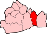
Reigate and Banstead is a local government district
with borough
status in east Surrey
England. It covers the towns of Reigate, Banstead
, Redhill
and Horley
.
The district was formed on 1 April 1974 under the Local Government Act 1972
. It was a merger of the former borough of Reigate with Banstead Urban District
and part of Dorking and Horley Rural District. There are two civil parishes within the borough: Horley
and Salfords and Sidlow
.
After the 3 May 2007 elections, there are 41 Conservatives
seats, six Reigate and Banstead Residents Association
, two Liberal Democrats
, one Labour
and one seat held by an Independent.
In recent years Reigate and Banstead Borough Council has been notable in seeing a number of younger councillors elected.
The borough is twinned with: Brunoy
in France Eschweiler
in Germany
had its head office in the Newman House in Horley
, Reigate and Banstead. At one time Air Europe
had its head office in Reigate
, Reigate and Banstead.
Non-metropolitan district
Non-metropolitan districts, or colloquially shire districts, are a type of local government district in England. As created, they are sub-divisions of non-metropolitan counties in a so-called "two-tier" arrangement...
with borough
Borough
A borough is an administrative division in various countries. In principle, the term borough designates a self-governing township although, in practice, official use of the term varies widely....
status in east Surrey
Surrey
Surrey is a county in the South East of England and is one of the Home Counties. The county borders Greater London, Kent, East Sussex, West Sussex, Hampshire and Berkshire. The historic county town is Guildford. Surrey County Council sits at Kingston upon Thames, although this has been part of...
England. It covers the towns of Reigate, Banstead
Banstead
Banstead is a town in the borough of Reigate and Banstead in the county of Surrey, England, on the border with Greater London. It lies south of London, west of Croydon and of the county town of Kingston-Upon-Thames. Banstead is on the North Downs and is protected by the Metropolitan Green Belt;...
, Redhill
Redhill, Surrey
Redhill is a town in the borough of Reigate and Banstead, Surrey, England and is part of the London commuter belt. Redhill and the adjacent town of Reigate form a single urban area.-History:...
and Horley
Horley
Horley is a town in Surrey, England, situated south of the twin towns of Reigate and Redhill, and north of Gatwick Airport and Crawley.With fast links by train to London from Horley railway station, it has grown popular with commuters in recent years...
.
The district was formed on 1 April 1974 under the Local Government Act 1972
Local Government Act 1972
The Local Government Act 1972 is an Act of Parliament in the United Kingdom that reformed local government in England and Wales on 1 April 1974....
. It was a merger of the former borough of Reigate with Banstead Urban District
Urban district
In the England, Wales and Ireland, an urban district was a type of local government district that covered an urbanised area. Urban districts had an elected Urban District Council , which shared local government responsibilities with a county council....
and part of Dorking and Horley Rural District. There are two civil parishes within the borough: Horley
Horley
Horley is a town in Surrey, England, situated south of the twin towns of Reigate and Redhill, and north of Gatwick Airport and Crawley.With fast links by train to London from Horley railway station, it has grown popular with commuters in recent years...
and Salfords and Sidlow
Salfords and Sidlow
Salfords and Sidlow is a civil parish in the Reigate and Banstead borough of Surrey, England. It has a population of 3,069. The parish includes the villages of Salfords and Sidlow....
.
After the 3 May 2007 elections, there are 41 Conservatives
Conservative Party (UK)
The Conservative Party, formally the Conservative and Unionist Party, is a centre-right political party in the United Kingdom that adheres to the philosophies of conservatism and British unionism. It is the largest political party in the UK, and is currently the largest single party in the House...
seats, six Reigate and Banstead Residents Association
Reigate and Banstead Residents Association
The Reigate and Banstead Residents Association holds six seats in the Reigate and Banstead borough in Surrey, England.In Nork Michael John Selby for the Nork Residents Association was elected with 1,420 votes whilst Paul Edward Tweedale for the Conservatives received 516 votes. Whilst in Tattenhams...
, two Liberal Democrats
Liberal Democrats
The Liberal Democrats are a social liberal political party in the United Kingdom which supports constitutional and electoral reform, progressive taxation, wealth taxation, human rights laws, cultural liberalism, banking reform and civil liberties .The party was formed in 1988 by a merger of the...
, one Labour
Labour Party (UK)
The Labour Party is a centre-left democratic socialist party in the United Kingdom. It surpassed the Liberal Party in general elections during the early 1920s, forming minority governments under Ramsay MacDonald in 1924 and 1929-1931. The party was in a wartime coalition from 1940 to 1945, after...
and one seat held by an Independent.
In recent years Reigate and Banstead Borough Council has been notable in seeing a number of younger councillors elected.
The borough is twinned with: Brunoy
Brunoy
Brunoy is a commune in the south-eastern suburbs of Paris, France. It is located from the center of Paris.Inhabitants of Brunoy are known as Brunoyens....
in France Eschweiler
Eschweiler
Eschweiler is a municipality in the district of Aachen in North Rhine-Westphalia in Germany on the river Inde, near the German-Belgian-Dutch frontier, and about 15 km east of Aachen and 50 km west of Cologne.- History :...
in Germany
Locations within the Borough
- BansteadBansteadBanstead is a town in the borough of Reigate and Banstead in the county of Surrey, England, on the border with Greater London. It lies south of London, west of Croydon and of the county town of Kingston-Upon-Thames. Banstead is on the North Downs and is protected by the Metropolitan Green Belt;...
, Burgh HeathBurgh HeathBurgh Heath is a residential area of the borough of Reigate and Banstead in Surrey, England. It is located on the A217 road, between Banstead and Tadworth. A neighbouring village is Nork... - Chipstead
- Earlswood
- EpsomEpsomEpsom is a town in the borough of Epsom and Ewell in Surrey, England. Small parts of Epsom are in the Borough of Reigate and Banstead. The town is located south-south-west of Charing Cross, within the Greater London Urban Area. The town lies on the chalk downland of Epsom Downs.-History:Epsom lies...
Small parts of Epsom are in Reigate and Banstead around Drift Bridge on Reigate Road - HooleyHooleyHooley is a small village in Surrey, England. It lies in a "pass" which is the lowest crossing point of the North Downs for some distance in either direction. Both the London, Brighton and South Coast Railway and the South Eastern Railway recognised this pass as the best route to Brighton and built...
, HorleyHorleyHorley is a town in Surrey, England, situated south of the twin towns of Reigate and Redhill, and north of Gatwick Airport and Crawley.With fast links by train to London from Horley railway station, it has grown popular with commuters in recent years... - Kingswood
- Lower KingswoodLower KingswoodLower Kingswood is a small village located in Surrey, just within the M25 motorway. It is between Kingswood and Reigate, and is bisected by the A217 dual carriageway...
- MeadvaleMeadvaleMeadvale is a suburb of Redhill in the borough of Reigate and Banstead in Surrey to the south of Redhill and Reigate.The census area Meadvale and St Johns has a population of 7,466.-History:...
, MersthamMersthamMerstham is a village in the Reigate and Banstead borough of Surrey, England, in the London commuter belt. It is just north of Redhill, near the intersection of the M25 and M23 motorways, on the edge of the North Downs and on the North Downs Way.-History:... - Netherne-on-the-HillNetherne-on-the-HillNetherne-on-the-Hill is a small village in Surrey, England, built on the site of the Victorian Netherne lunatic asylum. The village is situated in the borough of Reigate and Banstead. Local amenities include a swimming pool and a leisure centre for Netherne residents. opened in 1903 and closed in...
, NorkNork, SurreyNork is a residential area of the borough of Reigate and Banstead in Surrey, England. It is located between Banstead and Epsom Downs. The main road through the area from north to south-west is Nork Way, along which a parade of shops is located at the northern end.The buildings in the area are... - RedhillRedhill, SurreyRedhill is a town in the borough of Reigate and Banstead, Surrey, England and is part of the London commuter belt. Redhill and the adjacent town of Reigate form a single urban area.-History:...
, ReigateReigateReigate is a historic market town in Surrey, England, at the foot of the North Downs, and in the London commuter belt. It is one of the main constituents of the Borough of Reigate and Banstead... - SalfordsSalfordsSalfords is a village in the borough of Reigate and Banstead in Surrey, England. It lies approximately 3 miles or 5 km south of Redhill on the A23 London to Brighton road. It was the original UK home of the Monotype Corporation and Salfords railway station was originally built to service the...
, SidlowSidlowSidlow is a village in the parish of Salfords and Sidlow in the borough of Reigate and Banstead. It has a pub called the . The village also houses the Sidlow Bridge Centre which is a pupil referral unit.-External links:*...
, South ParkSouth Park, SurreySouth Park is a residential area of the Borough of Reigate and Banstead, Surrey, England. It lies to the south of Reigate Priory Park and to the west of Woodhatch.Local facilities include:*South Park Sports Association*Sandcross Lane Church...
, St Johns - TadworthTadworthTadworth is a large suburban village in Surrey, on the south-east slope of Epsom Downs. It forms part of the Borough of Reigate and Banstead. The census area Tadworth and Walton has a population of 7,016. Neighbouring settlements include Walton-on-the-Hill, Kingswood, Epsom, Burgh Heath, Banstead,...
, Tattenham CornerTattenham CornerTattenham Corner is a small town in Surrey, UK, located inside the M25 motorway thus being part of the London commuter belt. It is home to the Epsom Downs Racecourse. The location is to the west of the A240, with the M25 approximately five miles to the south... - Walton-on-the-HillWalton-on-the-HillWalton-on-the-Hill, Surrey, is a village in England, situated midway between Reigate and Epsom, just inside the M25 orbital motorway around London. It is situated close to the larger village of Tadworth. Other neighbouring villages include: Kingswood, Burgh Heath, Headley and Box Hill...
, WhitebushesWhitebushesWhitebushes is a small town in the Surrey borough of Reigate and Banstead. It is composed entirely of the housing estate of the same name. Its lies just south of Redhill. It lies on the opposite side of the railway from a town which has no specific name, but is usually called South Earlswood or...
, WoodhatchWoodhatchWoodhatch is a village in the Borough of Reigate and Banstead, Surrey, England. It lies just south of Reigate on the old London to Brighton road. Woodhatch is part of the census area South Park and Woodhatch which has a population on 7,145...
, WoodmansterneWoodmansterneWoodmansterne is a village in Reigate and Banstead borough of the county of Surrey, England. Woodmansterne village is located on the B278, which starts at Morden and winds through Carshalton past Oaks Park and into the village. The road continues down to Chipstead Bottom...
Economy
At one time the airline Dan-AirDan-Air
Dan-Air was a leading private, independentindependent from government-owned corporations airline based in the United Kingdom....
had its head office in the Newman House in Horley
Horley
Horley is a town in Surrey, England, situated south of the twin towns of Reigate and Redhill, and north of Gatwick Airport and Crawley.With fast links by train to London from Horley railway station, it has grown popular with commuters in recent years...
, Reigate and Banstead. At one time Air Europe
Air Europe
Air Europe was a wholly privately owned, independentindependent from government-owned corporations British airline, established in 1978 under the working title Inter European Airways. It adopted the Air Europe name the following year...
had its head office in Reigate
Reigate
Reigate is a historic market town in Surrey, England, at the foot of the North Downs, and in the London commuter belt. It is one of the main constituents of the Borough of Reigate and Banstead...
, Reigate and Banstead.