
South Cambridgeshire
Encyclopedia
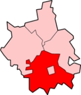
South Cambridgeshire is a mostly rural local government district
of Cambridgeshire
, England
. It was formed on 1 April 1974 by the merger of Chesterton Rural District
and South Cambridgeshire Rural District
. It surrounds the city of Cambridge
, which is administered separately from the district by Cambridge City Council
. On the abolition of South Herefordshire
and Hereford
districts to form the unitary Herefordshire
in 1998, it became the only English district to completely encircle another.
The district's coat of arms
contains a reference to the coat of arms of Cambridge University
. The motto, , means "Not Without Work" in old Dutch
; it was originally the motto of Cornelius Vermuyden
who drained The Fens
in the 17th century. The district council's headquarters moved from Cambridge to Cambourne in 2004.
South Cambridgeshire has scored highly on the best places to live, according to Channel 4
, which ranked South Cambridgeshire as the fifth best place to live in 2006. A Halifax survey rated South Cambridgeshire the best place to live in rural Britain.
The combined area of South Cambridgeshire, including both the South Cambridgeshire district and the city of Cambridge, is 1,017.28 km square.
- Babraham
- Balsham
- Bar Hill
- Barrington
- Bartlow
- Barton
- Bassingbourn cum Kneesworth
- Bourn - Boxworth
- Caldecote
- Cambourne - Carlton
- Castle Camps
- Caxton
- Childerley
- Chishills - Chittering
- Comberton
- Connington - Coton
- Cottenham
- Croxton
- Croydon
- Dry Drayton
- Duxford
- Elsworth
- Eltisley
- Fen Ditton
- Fen Drayton
- Fowlmere
- Foxton
- Fulbourn
- Gamlingay
- Girton
- Grantchester
- Graveley
- Great Abington - Great Eversden
- Great Shelford
- Great Wilbraham
- Guilden Morden
- Hardwick
- Harlton
- Harston
- Haslingfield
- Hatley
- Hauxton
- Heydon
- Hildersham
- Hinxton
- Histon
- Horseheath
- Horningsea
- Ickleton
- Impington - Kingston
- Knapwell
- Landbeach
- Linton
- Litlington
- Little Abington - Little Eversden
- Little Gransden
- Little Shelford
- Little Wilbraham
- Lolworth
- Longstanton
- Longstowe
- Madingley
- Melbourn
- Meldreth
- Milton
- Newton
- Oakington
- Orchard Park
- Orwell
- Over
- Pampisford
- Papworth Everard
- Papworth St Agnes
- Rampton
- Sawston
- Shepreth
- Shingay cum Wendy
- Shudy Camps
- Six Mile Bottom
- Stapleford
- Steeple Morden
- Stow-cum-Quy - Swavesey
- Tadlow
- Teversham
/Cherry Hinton
- Thriplow
& Heathfield - Toft
- Waterbeach
- West Wickham
- West Wratting
- Weston Colville
- Westwick
- Whaddon
- Whittlesford
- Willingham
- Wimpole
. The council consists of 57 councillors, representing 34 electoral wards. The Conservative Party
currently has a slim majority on the council, having gained control in the 2007 local elections. Prior to this, no party had overall control of the council.
has its head office on the grounds of Cambridge Airport
in South Cambridgeshire.
Non-metropolitan district
Non-metropolitan districts, or colloquially shire districts, are a type of local government district in England. As created, they are sub-divisions of non-metropolitan counties in a so-called "two-tier" arrangement...
of Cambridgeshire
Cambridgeshire
Cambridgeshire is a county in England, bordering Lincolnshire to the north, Norfolk to the northeast, Suffolk to the east, Essex and Hertfordshire to the south, and Bedfordshire and Northamptonshire to the west...
, England
England
England is a country that is part of the United Kingdom. It shares land borders with Scotland to the north and Wales to the west; the Irish Sea is to the north west, the Celtic Sea to the south west, with the North Sea to the east and the English Channel to the south separating it from continental...
. It was formed on 1 April 1974 by the merger of Chesterton Rural District
Chesterton Rural District
Chesterton was a rural district in Cambridgeshire, England from 1894 to 1974.It was formed in 1894 as a successor to the Chesterton rural sanitary district. In 1934, under a County Review Order, its boundaries were altered, taking in the disbanded Swavesey Rural District and part of the disbanded...
and South Cambridgeshire Rural District
South Cambridgeshire Rural District
South Cambridgeshire was a rural district in Cambridgeshire, England from 1934 to 1974.It was formed in 1934 under a County Review Order. It was formed by merger of Linton Rural District and Melbourn Rural District and part of Caxton and Arrington Rural District.In 1965 it became part of the new...
. It surrounds the city of Cambridge
Cambridge
The city of Cambridge is a university town and the administrative centre of the county of Cambridgeshire, England. It lies in East Anglia about north of London. Cambridge is at the heart of the high-technology centre known as Silicon Fen – a play on Silicon Valley and the fens surrounding the...
, which is administered separately from the district by Cambridge City Council
Cambridge City Council, England
Cambridge City Council is a district council in the county of Cambridgeshire, based in the city of Cambridge.-Activities:The council provides various facilities and services within the city...
. On the abolition of South Herefordshire
South Herefordshire
South Herefordshire was one of nine local government districts of the English county of Hereford and Worcester from 1974 to 1998.South Herefordshire District was formed on 1 April 1974 as part of a general reorganisation of local administration in England and Wales under the Local Government Act 1972...
and Hereford
Hereford
Hereford is a cathedral city, civil parish and county town of Herefordshire, England. It lies on the River Wye, approximately east of the border with Wales, southwest of Worcester, and northwest of Gloucester...
districts to form the unitary Herefordshire
Herefordshire
Herefordshire is a historic and ceremonial county in the West Midlands region of England. For Eurostat purposes it is a NUTS 3 region and is one of three counties that comprise the "Herefordshire, Worcestershire and Gloucestershire" NUTS 2 region. It also forms a unitary district known as the...
in 1998, it became the only English district to completely encircle another.
The district's coat of arms
Coat of arms
A coat of arms is a unique heraldic design on a shield or escutcheon or on a surcoat or tabard used to cover and protect armour and to identify the wearer. Thus the term is often stated as "coat-armour", because it was anciently displayed on the front of a coat of cloth...
contains a reference to the coat of arms of Cambridge University
University of Cambridge
The University of Cambridge is a public research university located in Cambridge, United Kingdom. It is the second-oldest university in both the United Kingdom and the English-speaking world , and the seventh-oldest globally...
. The motto, , means "Not Without Work" in old Dutch
Dutch language
Dutch is a West Germanic language and the native language of the majority of the population of the Netherlands, Belgium, and Suriname, the three member states of the Dutch Language Union. Most speakers live in the European Union, where it is a first language for about 23 million and a second...
; it was originally the motto of Cornelius Vermuyden
Cornelius Vermuyden
Sir Cornelius Wasterdyk Vermuyden was a Dutch engineer who introduced Dutch reclamation methods to Britain, and made the first important attempts to drain The Fens of East Anglia.-Life:...
who drained The Fens
The Fens
The Fens, also known as the , are a naturally marshy region in eastern England. Most of the fens were drained several centuries ago, resulting in a flat, damp, low-lying agricultural region....
in the 17th century. The district council's headquarters moved from Cambridge to Cambourne in 2004.
South Cambridgeshire has scored highly on the best places to live, according to Channel 4
Channel 4
Channel 4 is a British public-service television broadcaster which began working on 2 November 1982. Although largely commercially self-funded, it is ultimately publicly owned; originally a subsidiary of the Independent Broadcasting Authority , the station is now owned and operated by the Channel...
, which ranked South Cambridgeshire as the fifth best place to live in 2006. A Halifax survey rated South Cambridgeshire the best place to live in rural Britain.
The combined area of South Cambridgeshire, including both the South Cambridgeshire district and the city of Cambridge, is 1,017.28 km square.
List of settlements
Abington Piggotts - ArringtonArrington
Arrington is a village and civil parish in the South Cambridgeshire district of Cambridgeshire, England, with a population of 389 at the time of 2001 census. The village is north of Royston, Hertfordshire, and south-west of the county town of Cambridge....
- Babraham
Babraham
Babraham is a village and civil parish in the South Cambridgeshire district of Cambridgeshire, England, about six miles south-east of Cambridge on the A1307 road....
- Balsham
Balsham
Balsham is a rural village and civil parish in the county of Cambridgeshire, United Kingdom which has much expanded since the 1960s and is now one of several dormitory settlements of Cambridge...
- Bar Hill
Bar Hill
Bar Hill is a purpose-built village with a population of 4,000 about 4 miles northwest of Cambridge, England on the A14 road.The Prime Meridian passes just to the west of Bar Hill.-History:...
- Barrington
Barrington, Cambridgeshire
Barrington is a village and civil parish in the South Cambridgeshire district of Cambridgeshire, England. The village is about ten miles south-west of Cambridge, between Haslingfield and Shepreth....
- Bartlow
Bartlow
Bartlow is a small village and civil parish in the South Cambridgeshire district of Cambridgeshire, England, about south-east of Cambridge and west of Haverhill in Suffolk. The River Granta runs through the village.-History:...
- Barton
Barton, Cambridgeshire
Barton is a village and civil parish in the South Cambridgeshire district of Cambridgeshire, England. It is about south-west of Cambridge, near junction 12 of the M11 motorway.- History :...
- Bassingbourn cum Kneesworth
Bassingbourn cum Kneesworth
Bassingbourn cum Kneesworth is a civil parish in the South Cambridgeshire district of Cambridgeshire, England, 14 miles south-west of Cambridge. Since the 1960s the parish contains the villages of Bassingbourn and Kneesworth and is situated just north of Royston in Hertfordshire...
- Bourn - Boxworth
Boxworth
Boxworth is a village in Cambridgeshire not far from the rapidly-expanding developments of Cambourne and Bar Hill. It is situated about 8 miles to the north-west of Cambridge. It is within the diocese of Ely. The village covers an area of 1,053 ha...
- Caldecote
Caldecote, Cambridgeshire
Caldecote is a village in Cambridgeshire, in the district of South Cambridgeshire. It is located south of the A428, approximately six miles west of Cambridge and three miles east of Cambourne....
- Cambourne - Carlton
Carlton, Cambridgeshire
Carlton is a village near the eastern boundary of the county of Cambridgeshire in the east of England. It is in the civil district of South Cambridgeshire.There are some pictures and a description of the church at the Cambridgeshire Churches website....
- Castle Camps
Castle Camps
Castle Camps was a Norman Castle located in what is now the civil parish of Castle Camps, Cambridgeshire.-Owners:Castle Camps was originally a Saxon manor, belonging to Wulfwin, a Thane of King Edward the Confessor. After the Norman invasion, William the Conqueror gave the manor to Aubrey de Vere...
- Caxton
Caxton, Cambridgeshire
Caxton is a small rural village and civil parish in South Cambridgeshire, England. It is 9 miles west of the county town of Cambridge. In 2001, the population of Caxton parish was 480 people. Caxton is most famous for the Caxton Gibbet.-History:...
- Childerley
Childerley
Childerley, also known as Great Childerley and Little Childerly, was a small rural village in the county of Cambridgeshire in the East of England, United Kingdom.-Village history:...
- Chishills - Chittering
Chittering, Cambridgeshire
Chittering is a hamlet about 8 miles north of Cambridge in Cambridgeshire, England. For administrative purposes it is part of the parish of Waterbeach.The village lies on the Ely Road between Waterbeach and Stretham...
- Comberton
Comberton
Comberton is a village and civil parish in South Cambridgeshire, England, just east of the Prime Meridian.-History:Archaeological finds, including a Neolithic polished stone axe and a Bronze Age barrow , suggest there has been a settlement here for thousands of years. A Roman villa was discovered...
- Connington - Coton
Coton, Cambridgeshire
Coton is a small village and civil parish about two miles west of Cambridge in Cambridgeshire, England and about the same distance east of the Prime Meridian. It belongs to the administrative district of South Cambridgeshire. The parish covers an area of 392 hectares...
- Cottenham
Cottenham
Cottenham is a village in Cambridgeshire, England. It is close to The Fens. Before the fens were drained in the 19th century Cottenham was on the last contour before the waterlogged marshes, with Ely being the nearest dry land around to the north-east....
- Croxton
Croxton, Cambridgeshire
Croxton is a village and civil parish about 13 miles west of Cambridge in South Cambridgeshire, England. In 2001, the resident population was 163 people. Croxton Park is to the south of the current village and contains a large house and parkland....
- Croydon
Croydon, Cambridgeshire
Croydon is a village and civil parish in South Cambridgeshire, England. It is south-west of Cambridge and immediately west of the A1198 road . The population in 2001 was 221 people...
- Dry Drayton
Dry Drayton
Dry Drayton is a village and civil parish about 5 miles northwest of Cambridge in Cambridgeshire, England. It covers an area of .-History:...
- Duxford
Duxford
Duxford is a village in Cambridgeshire, England, some ten miles south of Cambridge.-History:The village formed on the banks of the River Cam, a little below its emergence from the hills of north Essex...
- Elsworth
Elsworth
Elsworth is a village and civil parish in South Cambridgeshire, England, 9 miles west of Cambridge. At the time of the 2001 census, the parish's population was 657.-History:...
- Eltisley
Eltisley
Eltisley is a village and civil parish in South Cambridgeshire, England, on the A428 road about 5.5 miles east of St Neots and about 11 miles west of the city of Cambridge. The population in 2001 was 421 people.-History:...
- Fen Ditton
Fen Ditton
Fen Ditton is a village on the northeast edge of Cambridge in Cambridgeshire, England. The parish covers an area of Fen Ditton lies on the east bank of the River Cam, on the road from Cambridge to Clayhithe, and close to junction 34 of the A14...
- Fen Drayton
Fen Drayton
Fen Drayton is a small village between Cambridge and St. Ives in Cambridgeshire, England, and between the villages of Fenstanton and Swavesey....
- Fowlmere
Fowlmere
Fowlmere is one of the southernmost villages in Cambridgeshire, England. It is very close to the Imperial War Museum Duxford, and 9 miles southwest of the city of Cambridge.- History :...
- Foxton
Foxton, Cambridgeshire
Foxton is a small village in South Cambridgeshire, England. It has a number of well-preserved fifteenth and sixteenth century houses, and a thirteenth century church dedicated to St Lawrence.-History:...
- Fulbourn
Fulbourn
Fulbourn is a village in Cambridgeshire, England. The term for a resident of the village is "Fulbourner".- Geography :Fulbourn lies about five miles south-east of the centre of Cambridge, separated from the outer city boundary by farmland and the grounds of Fulbourn Hospital. The village itself is...
- Gamlingay
Gamlingay
Gamlingay is a village and civil parish in South Cambridgeshire, England, near the border with Bedfordshire, and the traditional county of Huntingdonshire...
- Girton
Girton, Cambridgeshire
Girton is a village of about 1,600 households, and 4,500 people in Cambridgeshire, England. It lies about two miles to the northwest of Cambridge, and is the home of Cambridge University's Girton College, a pioneer in women's education, which was moved there from a previous site in Hertfordshire in...
- Grantchester
Grantchester
Grantchester is a village on the River Cam or Granta in Cambridgeshire, England. It is listed in the Domesday Book as Grantesete and Grauntsethe...
- Graveley
Graveley, Cambridgeshire
Graveley is a village and civil parish in South Cambridgeshire, England.-History:The parish of Graveley covers an area of at the western end of the historical county of Cambridgeshire. Until Huntingdonshire was merged into Cambridgeshire in 1965, its north, west, and south borders were with...
- Great Abington - Great Eversden
Great Eversden
Great Eversden is a village 6 miles south-west of Cambridge, England. The Prime Meridian runs through the parish just to the east of the village, separating it from Little Eversden.Great Eversden is a small village of about 85 houses...
- Great Shelford
Great Shelford
Great Shelford is a village located approximately four miles to the south of Cambridge, in the county of Cambridgeshire, in eastern England. In 1850 Great Shelford parish contained intersected by the river Cam. The population in 1841 was 803 people...
- Great Wilbraham
Great Wilbraham
Great Wilbraham is a small village situated in a rural area some seven miles to the east of Cambridge, between the edge of an area of low-lying drained fens to the west and north, and higher ground beyond the A11 to the east....
- Guilden Morden
Guilden Morden
Guilden Morden , England, is a village and parish located in Cambridgeshire about south west of Cambridge and west of Royston in Hertfordshire...
- Hardwick
Hardwick, Cambridgeshire
Hardwick is a village in the county of Cambridgeshire, England with a large housing estate located about west of the city of Cambridge and immediately south of the A428 Cambridge-St Neots road. It is about east of the newly developed village of Cambourne. The Village is nearly on the Greenwich...
- Harlton
Harlton
Harlton is a village and civil parish in the East of England region and the county Cambridgeshire in the United Kingdom. The village is south-west of Cambridge.-History:...
- Harston
Harston
Harston is a village to the south of Cambridge, England.-Harston House:Harston House is a historic private house in Harston. It was formerly known as Harston Hall....
- Haslingfield
Haslingfield
Haslingfield is a village and civil parish in South Cambridgeshire, England. The village is about six miles south-west of Cambridge, between Harston, Barton and Barrington. The population in the 2001 census was 1,550 people living in 621 households. The main streets in the village are called High...
- Hatley
Hatley, Cambridgeshire
Hatley is a civil parish in South Cambridgeshire, England. It lies between the villages of Gamlingay and Croydon, 12 miles south-west of the city of Cambridge and eight miles south-east of the town of St Neots...
- Hauxton
Hauxton
Hauxton is a small village in Cambridgeshire, England around 5 miles to the south-west of Cambridge.-History:Hauxton has been occupied for well over two thousand years thanks to its position on the River Cam and a ford near Hauxton Mill that has probably been used since the Bronze Age. A bridge was...
- Heydon
Heydon, Cambridgeshire
Heydon is a village in the East of England region and the county Cambridgeshire in the United Kingdom. The area of the village is . Heydon has the King William IV Pub as its only pub. The village also has the Wood Green Animal Shelter Small Animals Rescue Home...
- Hildersham
Hildersham
Hildersham is a small village 8 miles to the south-east of Cambridge, England. It is situated just off the A1307 between Linton and Great Abington on a tributary of the River Cam known locally as the River Granta...
- Hinxton
Hinxton
Hinxton is a village in South Cambridgeshire, England. It is the home to the Wellcome Trust Genome Campus, which includes the Wellcome Trust Sanger Institute and the European Bioinformatics Institute. The 2001 population was 315....
- Histon
Histon
Histon and Impington are villages in Cambridgeshire, England, They are situated just north of Cambridge with the main bulk of the settlements being separated from the city by the A14 road ....
- Horseheath
Horseheath
Horseheath is a hamlet in Cambridgeshire, England, situated a few miles south-east of Cambridge, between Linton and Haverhill, on the A1307 road....
- Horningsea
Horningsea
Horningsea is a small village north of Cambridge in Cambridgeshire in England. The parish covers an area of 6.63 km. It lies on the east bank of the River Cam, and on the road from Cambridge to Clayhithe...
- Ickleton
Ickleton
Ickleton is a village on the Cambridgeshire–Essex border in England. It grew at the point where the ancient Icknield Way crossed the River Cam, so it is likely that some form of habitation has existed on the site since prehistoric times...
- Impington - Kingston
Kingston, Cambridgeshire
Kingston is a small village and parish in the East of England region and the county Cambridgeshire in the United Kingdom. Situated 7 miles to the west of Cambridge, the population at the time of the 2001 census was 214....
- Knapwell
Knapwell
Knapwell is a small village in Cambridgeshire situated about west of Cambridge. It is within the diocese of Ely. Its population was estimated at 110 in 2001....
- Landbeach
Landbeach
Landbeach is a small fen-edge English village about five miles north of Cambridge. The parish covers an area of .-History:The fen edge north of Cambridge was well populated in Roman times, and the village's situation on a Roman road will have helped its growth...
- Linton
Linton, Cambridgeshire
Linton is a village in rural Cambridgeshire, England, on the border with Essex. It has been expanded much since the 1960s and is now one of many dormitory villages around Cambridge. The railway station was on the Stour Valley Railway between Cambridge and Colchester, now closed. The Rivey Hill...
- Litlington
Litlington, Cambridgeshire
Litlington is a village and civil parish in the East of England region and the county Cambridgeshire in the United Kingdom. The village lies around south west of Cambridge and north west of Royston.-History:...
- Little Abington - Little Eversden
Little Eversden
Little Eversden is a village approximately south-west of Cambridge, England. It has two main roads: Harlton Road which goes through Little Eversden and joins the A603, and High Street, which is a dead end....
- Little Gransden
Little Gransden
Little Gransden is 11 miles from the county town of Cambridgeshire, 10 miles south-east of Huntingdon and 47 miles north of London. The village stands on the B1046 road between Abbotsley, to the west, and Longstowe, to the east. A minor road runs south-west to Gamlingay...
- Little Shelford
Little Shelford
Little Shelford is a village located to the south of Cambridge, in the county of Cambridgeshire, in eastern England. The River Granta lies between it and the larger village of Great Shelford, and both are served by Shelford railway station, which is on the line from Cambridge to London Liverpool...
- Little Wilbraham
Little Wilbraham
Little Wilbraham is a village in Cambridgeshire, England, southeast of Cambridge between the A1303 and the A11. It is in the district of South Cambridgeshire. It is a small village with a population of only 394 and there is little employment within the village...
- Lolworth
Lolworth
Lolworth is a small village and civil parish in the district of South Cambridgeshire, in the county of Cambridgeshire, England, located approximately northwest of Cambridge city centre...
- Longstanton
Longstanton
Longstanton is a village in South Cambridgeshire, England, 6 miles northwest of Cambridge city centre.-History:For most of its history Longstanton was split into two parishes: the larger Long Stanton All Saints to the north and the smaller Long Stanton St. Michael to the south...
- Longstowe
Longstowe
-Demography:At the time of the 2001 census, Longstowe had 193 residents living in 73 households. All described themselves as White; 73.6% were Christian and 26.4% did not follow a religion or did not state one.-Landmarks:...
- Madingley
Madingley
Madingley is a village near Coton and Dry Drayton on the western outskirts of Cambridge in the United Kingdom.Known as Madingelei in the Domesday Book, the village's name means "Woodland clearing of the family or followers of a man called Mada"....
- Melbourn
Melbourn
Melbourn is a large village in the far south west of Cambridgeshire, England. It is located next to the A10 just north of Royston. Melbourn has over 4,400 inhabitants...
- Meldreth
Meldreth
Meldreth is a village in South Cambridgeshire with about 1,600 inhabitants lying around 10 miles south-west of Cambridge.-History:The village of Meldreth grew in Saxon times, and the parish is home to Mettle Hill that was probably the original meeting place of Armingford Hundred...
- Milton
Milton, Cambridgeshire
Milton is a village just north of Cambridge, England. It has a population of approximately 4,300 with 3,200 being on the electoral register. It expanded considerably in the late 1980s when two large housing estates were built between the bypass and the village resulting in a doubling of the...
- Newton
Newton, Cambridgeshire
Newton is a civil parish and small village in Cambridgeshire, England. Situated around 7 miles to the south-west of Cambridge, its lies on the old coaching road between London and Cambridge...
- Oakington
Oakington
Oakington is a small village 4 miles north-west of Cambridge in Cambridgeshire in England, and belongs to the administrative district of South Cambridgeshire. The village falls into the parish of Oakington and Westwick.-History:...
- Orchard Park
Orchard Park, Cambridgeshire
Orchard Park, previously known as Arbury Park and before that Arbury Camp, is a district and civil parish of South Cambridgeshire, England, contiguous with the city of Cambridge...
- Orwell
Orwell, Cambridgeshire
Orwell is a small rural village outside Cambridge in South Cambridgeshire, England.The Prime Meridian passes the eastern edge of Orwell.-History:...
- Over
Over, Cambridgeshire
Over is a large village near the River Great Ouse in the English county of Cambridgeshire, just east of the Prime Meridian.The parish covers an area of approximately...
- Pampisford
Pampisford
Pampisford is a village, south of Cambridge, on the A505 road near Sawston, Cambridgeshire, England.Pampisford Hall, the principal house of the village, was rebuilt to the designs of George Goldie for James Binney, whose descendants still live there...
- Papworth Everard
Papworth Everard
Papworth Everard is a village in Cambridgeshire, England. It lies ten miles west of Cambridge and six miles south of Huntingdon, having along its centre Ermine Street, the old North Road, the Roman highway that for centuries served as a major artery from London to York, which is now the A1198...
- Papworth St Agnes
Papworth St Agnes
Papworth St Agnes is a village and civil parish in South Cambridgeshire, England.- History :The original village can be traced in the settlement remains between existing cottages and the Manor house....
- Rampton
Rampton, Cambridgeshire
Rampton is a village in Cambridgeshire, England. Situated on the edge of The Fens six miles to the north of Cambridge, it is a relatively small village of only around 400 people but has a thriving community.-History:...
- Sawston
Sawston
Sawston is a large village in Cambridgeshire in England, situated on the River Cam seven miles south of Cambridge. It has a population of 7,150...
- Shepreth
Shepreth
Shepreth is a village and civil parish in South Cambridgeshire, lying halfway between Cambridge and Royston.-History:The parish of Shepreth is roughly-rectangular and covers 1318 acres...
- Shingay cum Wendy
Shingay cum Wendy
Shingay cum Wendy is a civil parish in the English county of Cambridgeshire, around 5 miles north west of Royston.Forming part of the district of South Cambridgeshire's Bassingbourn Ward the parish's main settlements are Shingay and Wendy....
- Shudy Camps
Shudy Camps
Shudy Camps is a village in Cambridgeshire, England. As of the 2001 census the population is 310. The area of the village is .-External links:*...
- Six Mile Bottom
Six Mile Bottom
Six Mile Bottom is a hamlet within the parish of Little Wilbraham, near Cambridge in England.-History:In the 1790s the only building at Six Mile Bottom was a paddocks run by a stable keeper. In 1802, a sizeable country house was built nearby...
- Stapleford
Stapleford, Cambridgeshire
Stapleford is a village located approximately four miles to the south of Cambridge, in the county of Cambridgeshire, in eastern England on the right hand bank of the River Granta. Stapleford is first mentioned in 956 when it was given the Latinised name of Stapelforda, formerly Stapleton. Unlike...
- Steeple Morden
Steeple Morden
Steeple Morden is a village and civil parish in Cambridgeshire, England, about south west of Cambridge and west of Royston. It is part of the South Cambridgeshire local government district....
- Stow-cum-Quy - Swavesey
Swavesey
Swavesey is a village lying on the Greenwich Meridian in Cambridgeshire, England, with an approximate population of 2,480. The village is situated 9 miles to the north west of Cambridge and 3 miles south east of St...
- Tadlow
Tadlow
Tadlow is south-west of Cambridge, north-east of Biggleswade, Bedfordshire, and north of London. The B1042 road bisects the parish, with Wrestlingworth to the west and Croydon to the east....
- Teversham
Teversham
Teversham is a small village in Cambridgeshire located roughly from Fulbourn, and is roughly from the centre of Cambridge. It is a small village compared to neighbouring ones...
/Cherry Hinton
Cherry Hinton
Cherry Hinton is a suburban area of the city of Cambridge, in Cambridgeshire, England. It is around southeast of Cambridge city centre.-History:...
- Thriplow
Thriplow
Thriplow is a village in Cambridgeshire, England, south of Cambridge. The village also gives its name to a former Cambridgeshire hundred.-History:...
& Heathfield - Toft
Toft, Cambridgeshire
Toft is a village situated in Cambridgeshire, England. It is approximately six miles to the west of Cambridge, and is situated within four miles of the M11 motorway. It has approximately 600 residents and 200 homes. Comberton Village College falls within the Toft Parish boundary...
- Waterbeach
Waterbeach
Waterbeach is a large fen-edge village located 6 miles north of Cambridge in Cambridgeshire in England, and belongs to the administrative district of South Cambridgeshire. The parish covers an area of 23.26 km².- Village :...
- West Wickham
West Wickham, Cambridgeshire
West Wickham is a village and civil parish in South Cambridgeshire, England, 10 miles south-east of Cambridge on the border with Suffolk.-History:...
- West Wratting
West Wratting
West Wratting is a village and civil parish 10 miles southeast of Cambridge in Cambridgeshire. At above sea level, it can claim to be the highest village in Cambridgeshire, although the Gog Magog Hills are a little higher....
- Weston Colville
Weston Colville
Weston Colville is a village in South Cambridgeshire, 10 miles southeast of Cambridge and 6 miles south of Newmarket, close to the border with Suffolk.-History:...
- Westwick
Westwick, Cambridgeshire
Westwick is a hamlet in Cambridgeshire, in England. It is situated to the north-west of Cambridge, and is part of the parish of Oakington and Westwick...
- Whaddon
Whaddon, Cambridgeshire
Whaddon is a village and civil parish in South Cambridgeshire, England, north of Royston.-History:The parish of Whaddon covers an area of . Its entire western boundary follows the Roman Ermine Street , separating it from Bassingbourn and Wendy, and its northern border follows the River Cam,...
- Whittlesford
Whittlesford
Whittlesford is a village in Cambridgeshire, England, and also the name of an old hundred. The village is situated on the Granta branch of the River Cam, seven miles south of Cambridge...
- Willingham
Willingham, Cambridgeshire
Willingham is a medium to large village in Cambridgeshire, England. It is located on the edge of the Fens just south of the River Ouse. Driving north from the village one may observe the characteristic elevated straight roads and black soil....
- Wimpole
Wimpole
Wimpole is a village and civil parish in South Cambridgeshire, England, about 8½ miles southwest of Cambridge. It is sometimes sub-divided into "Old Wimpole" and "New Wimpole". People from Wimpole include the Independent minister John Conder...
Local government
South Cambridgeshire District Council's headquarters are located in South Cambridgeshire Hall in the Cambourne Business Park in CambourneCambourne
Cambourne is a new settlement and civil parish in Cambridgeshire, England, in the district of South Cambridgeshire. It lies on the A428 road between Cambridge, 9 miles to the east, and St Neots and Bedford to the west. It comprises the three villages of Great Cambourne, Lower Cambourne and Upper...
. The council consists of 57 councillors, representing 34 electoral wards. The Conservative Party
Conservative Party (UK)
The Conservative Party, formally the Conservative and Unionist Party, is a centre-right political party in the United Kingdom that adheres to the philosophies of conservatism and British unionism. It is the largest political party in the UK, and is currently the largest single party in the House...
currently has a slim majority on the council, having gained control in the 2007 local elections. Prior to this, no party had overall control of the council.
Economy
ScotAirwaysScotAirways
Suckling Airways is an airline that focuses on ACMI work and ad hoc corporate charters for business and sporting organisations...
has its head office on the grounds of Cambridge Airport
Cambridge Airport
Cambridge Airport is a small regional airport in South Cambridgeshire, England. It is located on the eastern outskirts of Cambridge, south of Newmarket Road and west of the village of Teversham, from the centre of Cambridge and approximately from London.Opened in 1938, when it replaced the old...
in South Cambridgeshire.