

Shropshire
Encyclopedia
Shropshire is a county
in the West Midlands region
of England. For Eurostat
purposes, the county (less the unitary district of Telford and Wrekin
) is a NUTS 3 region (code UKG22) and is one of four counties or unitary districts that comprise the "Shropshire and Staffordshire" NUTS 2 region
. It borders Wales
to the west. Shropshire is one of England's most rural and sparsely populated counties with a population density of 91/km2 (337/sq mi). The shire county
and its districts were replaced by a unitary authority
on 1 April 2009. The borough of Telford and Wrekin
, included in Shropshire for ceremonial purposes
, has been a unitary authority since 1998.
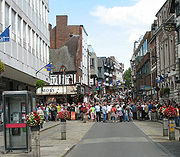
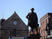
The county is centred on six main towns starting with the county town
of Shrewsbury
, which is culturally and historically important, although Telford
, which was constructed around a number of older towns, most notably Wellington
, Dawley
and Madeley
, is today the most populous. The other main towns are Oswestry
in the north-west, Newport
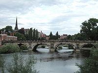
to the east, Bridgnorth
in the south-east, and Ludlow
to the south. Whitchurch
and Market Drayton
in the north of the county are also of notable size.
The Ironbridge Gorge
area is a UNESCO World Heritage Site
, covering Ironbridge
, Coalbrookdale
and a part of Madeley
. There are, additionally, other notable historic industrial sites located around the county, such as Broseley
, Snailbeach
and Highley
as well as the Shropshire Union Canal
.
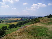
The Shropshire Hills Area of Outstanding Natural Beauty covers about a quarter of the county, mainly in the south. The Wrekin
is one of the most famous natural landmarks in the county, though the highest hills are the Clee Hills
, Stiperstones
and the Long Mynd
. Wenlock Edge
is another significant geographical and geological landmark. In the low-lying northwest of the county (and overlapping the border with Wales) is the Fenn's, Whixall and Bettisfield Mosses National Nature Reserve, one of the most important and best preserved bogs in Britain. The River Severn
, Great Britain's longest river, runs through the county, exiting into Worcestershire
via the Severn Valley
. Shropshire is landlocked, and with an area of 3197 square kilometres (1,234.4 sq mi), is England's largest inland county.
The County flower is the round-leaved sundew.
kingdom. Their capital in pre-Roman
times was probably a hill fort
on The Wrekin
. Ptolemy
's 2nd century Geography names one of their towns as being Viroconium Cornoviorum (Wroxeter
), which became their capital under Roman rule
and one of the largest settlements in Britain. After the Roman occupation of Britain ended in the 5th century, the Shropshire area was in the eastern part of the Welsh Kingdom of Powys; known in Welsh poetry as the Paradise of Powys. It was annexed to the Saxon kingdom of Mercia
by King Offa
in the eighth century, at which time he built two significant dykes there to defend his territory against the Welsh
or at least demarcate it. In subsequent centuries, the area suffered repeated Danish invasion, and fortresses were built at Bridgnorth
and Chirbury.
After the Norman Conquest in 1066, major estates in Shropshire were granted to Normans, including Roger de Montgomerie, who ordered significant constructions, particularly in Shrewsbury, the town of which he was Earl
. Many defensive castles were built at this time across the county to defend against the Welsh and enable effective control of the region, including Ludlow Castle
and Shrewsbury Castle
. The western frontier with Wales was not finally determined until the 14th Century. Also in this period, a number of religious foundations were formed, the county largely falling at this time under the diocese of Hereford and that of Coventry and Lichfield. Some areas in later times fell under the diocese of St. Asaph until it ceased to exist in 1920.
The county was a central part of the Welsh Marches
during the medieval period and was often embroiled in the power struggles between powerful Marcher Lords
, the Earls of March and successive monarchs.
The county also contains a number of historically significant towns, including Shrewsbury
, Ludlow
and Oswestry
. Additionally, the area around Coalbrookdale
in the county is seen as highly significant, as it is regarded as one of the birthplaces of the Industrial Revolution
. The village of Edgmond
, near Newport
, is the location of the lowest recorded temperature (in terms of weather) in England and Wales.
shire).
Salop is an old abbreviation for Shropshire, sometimes used on envelopes or telegrams, and comes from the Anglo-French "Salopesberia". It is normally replaced by the more contemporary "Shrops" although Shropshire residents are still referred to as "Salopians".
When a county council for the county was first established in 1888, it was called Salop County Council. Following the Local Government Act 1972
, Salop became the official name of the county, but a campaign led by a local councillor, John Kenyon, succeeded in having both the county and council renamed as Shropshire in 1980.
) and Pimhill (including Wem
), and part of Chirbury
had prior to the Laws in Wales Act formed various Lordships in the Welsh Marches
.
The present day ceremonial county boundary is almost the same as the historic one. Notably there has been the removal of several exclaves and enclaves. The largest of the exclaves was Halesowen
, which became part of Worcestershire in 1844 (now part of the West Midlands
county), and the largest of the enclaves was Herefordshire's Farlow
in South Shropshire, also transferred in 1844, to Shropshire. Alterations have been made on Shropshire's border with all neighbouring English counties over the centuries. Gains have been made to the south of Ludlow (from Herefordshire), to the north of Shifnal (from Staffordshire) and to the north (from Cheshire) and south (from Staffordshire) of Market Drayton. The county has lost land in two places – to Staffordshire and Worcestershire.
 Geographically, Shropshire is divisible into two distinct halves – North and South. The county has a highly diverse geology
. The West Midlands green belt
extends into eastern Shropshire, covering an area north from Highley, to the east of Bridgnorth, north to the eastern side of Telford, leaving Shropshire eastwards alongside the A5. This encompasses Shifnal, Cosford and Albrighton, and various other villages paralleling Dudley and Wolverhampton.
. It is here that most of the county's large towns, and population in general, are to be found. Shrewsbury
at the centre, Oswestry
to the north west, Whitchurch
to the north, Market Drayton
to the north east, and Newport
and the Telford conurbation (Telford, Wellington, Oakengates, Donnington and Shifnal) to the east. The land is fertile and agriculture remains a major feature of the landscape and the economy. The River Severn
runs through the lower half of this area (from Wales in the west, eastwards), through Shrewsbury and down the Ironbridge Gorge
, before heading south to Bridgnorth
.
The area around Oswestry
has more rugged geography than the North Shropshire Plain and the western half is over an extension of the Wrexham
Coalfield and there are also copper deposits on the border with Wales
. Mining of stone and sand aggregates
is still going on in Mid-Shropshire
, notably on Haughmond Hill
, near Bayston Hill
and around the village of Condover
. Lead mining also took place at Snailbeach
and the Stiperstones
, but this has now ceased. Other primary industries, such as forestry and fishing, are to be found too.
 The A5 and M54
run from Wolverhampton
(to the east of the county) across to Telford, around Shrewsbury parallel to the line of Watling Street
an ancient trackway
. The A5 then turns north west to Oswestry, before heading north into Wales in the Wrexham area. This is an important artery and the corridor is where most of Shropshire's modern commerce and industry is found, notably in Telford new town. There are also a number of railway lines crossing over the area, which centre at Shrewsbury. To the south west of Telford, near the Ironbridge Gorge, is Ironbridge Power Station
.
The new town of Telford is built partly on a former industrial area centred on the East Shropshire Coalfield as well as on former agricultural land. There are still many ex-colliery sites to be found in the area, as well as disused mine shafts. This industrial heritage is an important tourist attraction, as is seen by the growth of museums in the Ironbridge
, Coalbrookdale
, Broseley
and Jackfield
area. Blists Hill museum and historical (Victorian era
) village is a major tourist attraction as well as the Iron Bridge itself. In addition, Telford Steam Railway
runs from Horsehay
.
South Shropshire is more rural, with fewer settlements and no large towns, and its landscape differs greatly from that of North Shropshire. The area is dominated by significant hill ranges and river valleys, woods, pine forests and "batches", a colloquial term for small valleys and other natural features. Farming is more pastoral than the arable found in the north of the county. The only substantial towns are Bridgnorth
, with a population of around 12,000 people, Ludlow
and Church Stretton
. The Shropshire Hills AONB
is located in the south-west, covering an area of 808 km² (312 sq mi); it forms the only specifically protected area of the county. Inside this area is the popular Long Mynd
, a large plateau of 516 m (1,692.9 ft) and Stiperstones
536 metres (1,758.5 ft) high to the East of the Long Mynd
, overlooking Church Stretton
.
 The A49
is the main road through the area, running north to south, from Shrewsbury to Herefordshire
. A railway line runs through the area on the same route as the A49 with stations at Church Stretton, Craven Arms
and Ludlow. The steam heritage Severn Valley Railway
runs from Bridgnorth into Worcestershire
along the Severn Valley
.
Because of its valley location and character, Church Stretton is sometimes referred to as Little Switzerland
. Nearby are the old mining and quarrying communities on the Clee Hills
, notable geological features in the Onny Valley
and Wenlock Edge
and fertile farmland in the Corve Dale. The River Teme
drains this part of the county, before flowing into Worcestershire
to the South and joining the River Severn.
One of the Clee Hills, the Brown Clee Hill
, is the county's highest peak at 540 metres (1,772 ft). This gives Shropshire the 13th tallest hill per county in England.
South West Shropshire is a little known and remote part of the county, with Clun Forest
, Offa's Dyke
, the River Clun
and the River Onny
. The small towns of Clun
and Bishop's Castle
are in this area. The countryside here is very rural and is in parts wild and forested. To the south of Clun is the Welsh border town of Knighton.
of Shropshire is generally moderate. Rainfall averages 760 to 1,000 mm (30 to 40 in), influenced by being in the rainshadow of the Cambrian Mountains
from warm, moist frontal systems of the Atlantic Ocean which bring generally light precipitation in Autumn and Spring. The hilly areas in the south and west are much colder in the winter, due to their high elevation, they share a similar climate to that of the Welsh Marches
and Mid-Wales. The flat northern plain in the north and east has a similar climate to that of the rest of the West Midlands
.
Being rural and inland, temperatures can fall more dramatically on clear winter nights than in many other parts of England. It was at Harper Adams University College
, in Edgmond
, where on 10 January 1982 the lowest temperature weather record for England was broken (and is kept to this day): -26.1 °C.
The only Met Office weather station in the county is located at Shawbury
, which is in the north, between Shrewsbury
and Market Drayton
.
. Shropshire has a number of areas with Silurian
and Ordivician rocks, where a number of shells
, coral
s and trilobite
s can be found. Mortimer Forest is an example where a number of fossil
s can be found.
, but 22 towns, of which 2 can be considered major. Telford
is the largest town in the county with a population of 138,241 (which is approximately 30% of the total Salopian populace); whereas the county town
of Shrewsbury
has a lower, but still sizeable population of 70,560 (15%). The other sizeable towns are Oswestry
, Bridgnorth
, Newport
and Ludlow
. The historic town of Wellington
now makes up part of the Telford conurbation. The majority of the other settlements can be classed as villages or small towns such as Much Wenlock
. The larger settlements are primarily concentrated in a central belt that roughly follows the A5/M54
roadway. Other settlements are concentrated on rivers, e.g. Ironbridge
on the Severn, as these waterways were historically vital to trade.
The town of Telford
was created by the merger of older small towns surrounding the Wrekin. These towns now have sizeable populations that now make up the population of Telford, but still have unique characters, these are Wellington
(20,430), Madeley
(17,935), Dawley
(11,399) and Oakengates
(8,517), but the Telford and Wrekin borough towns incentive aims to make Oakengates into the largest of the towns.
purposes, Shropshire County Council is a NUTS 3 region (code UKG22). The county has five parliamentary constituencies, four of which returned Conservative MPs at the 2005 general election and one, Telford, returned a Labour MP. This is a marked change from the 2001 general election result, where the county returned only one Conservative, three Labour and a Liberal Democrat to the Commons (see maps to the right) (Labour = Red, Conservatives = Blue and
Liberal Democrats = Orange).
The current MPs of Shropshire are:
In 2005 there was also a County Council election in which the Conservatives gained overall control of the shire county. Telford and Wrekin Borough Council remained at the time under Labour control but has since gone to no-overall control, with a Conservative executive. Being a rural county, there are a number of independent councillors on the various councils in the county.
The Conservatives gained complete control of Shrewsbury and Atcham Borough Council in the May 2006 local elections.
of Shropshire is covered for purposes of local government by Shropshire Council
, a unitary authority
established in 2009. Telford and Wrekin
is a unitary authority, with borough
status, which forms part of the county for various functions such as Lord Lieutenant
but is a separate local authority from Shropshire Council. However many services are shared across both authorities, such as the fire and rescue service
, and the two authorities co-operate on some projects such as mapping flood risk.
The ceremonial county borders Cheshire
, Staffordshire, Worcestershire, Herefordshire
, and the Welsh preserved counties
of Powys
and Clwyd
.
The new unitary authority for Shropshire, Shropshire Council
, divides the county into three areas, each with its own area committee
– North, Central and South. These area committees, as well as relative staff, deal with local matters such as development control and licensing.
With the parishing of the formerly unparished area
of Shrewsbury in 2008, the entire ceremonial county is now parished. The sizes of parishes varies enormously in terms of area covered and population resident. Shrewsbury is the most populous parish in the county (and one of the most populous in England) with over 70,000 residents, whilst Boscobel
is the smallest parish in Shropshire by geographical area and by population, with just 12 residents according to the 2001 census. The smaller parishes (with populations of less than 200) usually have a joint parish council with one or more neighbouring parishes, or in some instances, have a parish meeting
(such as in Sibdon Carwood
). The urban area of Telford is divided into many parishes, each covering a particular suburb, some of which are historic villages or towns (such as Madeley
). The parish remains an important sub-division and tier of local government in both unitary authority areas of Shropshire.
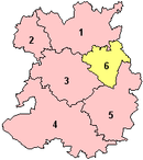 In 1974 the non-metropolitan county of Shropshire was constituted, covering the entire county. There was a two-tier system of local government, constituting a county council
(as the upper tier) and six district
councils – Bridgnorth
, North Shropshire
, Oswestry
, Shrewsbury and Atcham
, South Shropshire
and The Wrekin
. In 1998 The Wrekin became a unitary authority
, administratively separate from the county council, and became Telford and Wrekin. The two-tier structure remained in the remainder of the county and was the least populated two-tier area in England.
Oswestry and Shrewsbury & Atcham were each granted borough
status in 1974. Telford and Wrekin became a borough in 2002.
to be set up in England in certain areas. Existing non-metropolitan counties with small populations, such as Cornwall
, Northumberland and Shropshire, were favoured by the government to be covered by unitary authorities in one form or another (the county either becoming a single unitary authority, or be broken into a number of unitary authorities). For the counties in the 2009 reorganisation, existing unitary authority areas within the counties' ceremonial boundaries
(such as Telford and Wrekin) were not to be affected and no boundary changes were planned.
Shropshire County Council, supported by South Shropshire District Council and Oswestry Borough Council, proposed to the government that the non-metropolitan county of Shropshire become a single unitary authority. This was opposed by the other 3 districts in the county, with Shrewsbury & Atcham Borough Council taking their objection to the High Court in a judicial review.
The proposal to create a Shropshire unitary authority, covering the area of the existing non-metropolitan county, was supported by the DCLG and 1 April 2009 was set as the date for the re-organisation to take place. The first elections to Shropshire Council will not take place however until 4 June 2009, with the former Shropshire County Council being the continuing authority and its councillors became the first members of the new Shropshire Council on 1 April.
Part of the proposals include parishing
and establishing a town council
for Shrewsbury. The parish was created on 13 May 2008 and is the second most populous civil parish in England (only Weston-super-Mare
has a greater population) with a population of over 70,000.
Shropshire is connected to the rest of the United Kingdom via a number of road and rail links. Historically, rivers and later canals in the county were used for transport also, although their use in transport is now significantly reduced. The county's main transportation hub is Shrewsbury, through which many significant roads and railways pass and join.
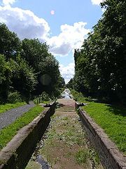
Canals in the United Kingdom
today serve primarily for leisure purposes and three British Waterways
canals run through Shropshire: the Shropshire Union Canal
(from north of Adderley
to near Knighton), the Llangollen Canal
(from Chirk Aqueduct
to Grindley Brook
) and the Montgomery Canal
(from its beginning at Frankton Junction
to Llanymynech
). In addition, the Shrewsbury and Newport Canal
potentially could be restored in the
future.
Major roads in the county include the M54 motorway
, which connects Shropshire to the rest of the motorway network, and more specifically to the West Midlands county. The A5 also runs through the county, in an east-west direction. The road formerly ran through Shrewsbury, although a large dual-carriageway bypass has since been built. Other major trunk roads in the county include the north-south A49
, the A53
and the A41
.
There are a number of major railway
lines running through the county, including the Welsh Marches Line
, the Cambrian Line
, the Shrewsbury to Chester Line
and the Wolverhampton to Shrewsbury Line
, as well as heritage railway
s including the well established Severn Valley Railway
. The two train operating companies working in the county are London Midland
and Arriva Trains Wales
. A new company, Wrexham & Shropshire, commenced services from Shropshire to London Marylebone station
, in spring 2008 but the service was discontinued on 28 January 2011 leaving Shrewsbury without a direct link to the capital.
Two major water supply aqueduct
s run across Shropshire; the Elan aqueduct
running through South Shropshire carrying water from Elan Valley
to Birmingham
and the Vyrnwy Aqueduct running through North Shropshire delivering water from Lake Vyrnwy
to Liverpool
.
 The economy of Shropshire was traditionally dominated by agriculture. However, in more recent years it has become more service orientated. The county town of Shrewsbury
, the historic castle-dominated Ludlow
, the International Olympic Movement's birthplace Much Wenlock
and the industrial birthplace of Ironbridge Gorge
are the foremost tourist areas in Shropshire, along with the reclaimed canal network which provides canal barge holidays on the Shropshire Union Canal
and linked canal networks in the region, although the natural beauty of the county draws people to all areas.
Industry is mostly found in Telford
, Oswestry
, Whitchurch
, Market Drayton
and Shrewsbury, though small industrial estates can be found in and Church Stretton
and Newport
where the main industrial factory Audco, closed in 1982. The town has then started to move more towards an agricultural and tourist industry much like Ludlow
, though industry is starting to build up along the outskirts of the town on the A41 road
, because of its possession on the route between Wolverhampton
, Birmingham, Staffordshire and the north. Shrewsbury is becoming a centre for distribution and warehousing, as it is located on a nodal point of the regional road network.
In Telford, a new rail freight facility has been built at Donnington
with the future goal of extending the line to Stafford
, this is hoped it would open the freight terminal up to the East Midlands
and the north, plus also re-connect Newport
to the rail network.
Telford and Shrewsbury are the county's two main retail centres, with contrasting styles of shopping – Shrewsbury's largely historic streets and Telford's large modern mall, Telford Shopping Centre
. Shrewsbury also has two medium-sized shopping centres, the indoor "Pride Hill" and "Darwin
" centres (both located on Pride Hill), and a smaller, partially covered, "Riverside Mall". Shrewsbury's situation of being the nearest substantial town for those in a large area of mid-Wales
helps it draw in considerable numbers of shoppers, notably on Saturday.
Well-known companies in Shropshire include Müller Dairy (UK) Ltd
in Market Drayton
. The RAF have two bases at RAF Cosford and RAF Shawbury
, and the charity PDSA
has its head office in Priorslee
, Telford.
.
With the statistics for the borough of Telford and Wrekin
included, the following represents the ceremonial county:
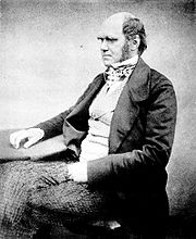
, which Charles Darwin
attended and Oswestry School
, which is the second oldest school in the country, founded in 1407.
In the Borough of Telford and Wrekin borough has two selective schools, all of which are located in Newport
, these are the Adams' Grammar School
and Newport Girls' High School (both of which are ranked within the top thirty schools in the country), and the independent preparatory school
Castle House, in Telford itself is the Thomas Telford School
is also a notable school, ranked as one of the best comprehensive schools in England.
There is considerable rivalry between many of the county's schools. In Shrewsbury for example, the Priory and Meole Brace schools maintain a long-standing sporting rivalry whilst on a wider scale Wrekin College
and Ellesmere College
remain rivals, as do Shrewsbury School and Adams' Grammar School.
There are also two institutions of higher education in Shropshire, the Telford campus of Wolverhampton University and in Edgmond, near Newport, Harper Adams University College
, which formerly offered mostly agriculture-based degrees but is expanding its range of provision.
In Ironbridge, the University of Birmingham
operates the Ironbridge Institute
in partnership with the Ironbridge Gorge Museum Trust
, which offers postgraduate and professional development courses in heritage.
Shropshire has the highest educational attainment in the West Midlands region.
.jpg)
 There are a significant number of sporting clubs and facilities in Shropshire, many of which are found in Shrewsbury and Telford in addition to a number of clubs found locally throughout the county. Shropshire is home to a variety of established amateur, semi-pro and professional sports clubs.
The county is home to one of five National Sports Centres
. Situated at Lilleshall Hall
just outside Newport
in Lilleshall
, this is where the 1966 England National football team
trained for two weeks prior to their success in the World Cup of 1966
.
(English League Two), Telford United
(English Conference) and The New Saints
(Welsh Premier) in Oswestry. There are further football clubs in lower leagues, the highest of which is Market Drayton Town
. The governing body
in the county is the Shropshire Football Association
. the following Shropshire clubs play in these English leagues (the highest team of each club shown only):
team, Shropshire Revolution
, which was founded in 2006, and is a club in the British American Football League
. Former teams in the county have included the Wrekin Giants
, which ran from 1985 to 1989 and the Shropshire Giants which ran in 1989. Shropshire has a number of rugby clubs, including Newport (Salop) Rugby Union Football Club
, the highest-leveled team in the county, playing in the National League 3 Midlands
.
 The area also has a rich motorsports heritage, with the Loton Park Hillclimb and Hawkstone Park Motocross Circuit
situated near Shrewsbury. Shrewsbury Motocross Club
has staged motocross
events in the area for over 30 years. There is additionally an ice hockey club in the county, the Telford Tigers
.
The county has a number of private and public golf courses, including the Church Stretton Golf Club, situated on the slopes of the Long Mynd
. It is the oldest 18-hole golf course in Shropshire, opened in 1898, and one of the highest in the United Kingdom. There is one notable horse racing racecourse in Shropshire, near Ludlow, the Ludlow Racecourse
.
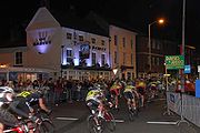
One of the biggest one day events in Shropshire and the biggest one day cycle race in the UK is the Shropshire Star Newport Nocturne
, held every four years it is Britain's only floodlit cycle race.
The historic Wenlock Olympian Society Annual Games
are held annually in Much Wenlock
during the second weekend in July. A four-day festival, the Games include cricket, volleyball, tennis, bowls, badminton, triathlon, 10k road race, track and field events, archery, five-a-side football, veteran cycle events, clay pigeon shooting and a golf competition.
Counties of England
Counties of England are areas used for the purposes of administrative, geographical and political demarcation. For administrative purposes, England outside Greater London and the Isles of Scilly is divided into 83 counties. The counties may consist of a single district or be divided into several...
in the West Midlands region
West Midlands (region)
The West Midlands is an official region of England, covering the western half of the area traditionally known as the Midlands. It contains the second most populous British city, Birmingham, and the larger West Midlands conurbation, which includes the city of Wolverhampton and large towns of Dudley,...
of England. For Eurostat
Eurostat
Eurostat is a Directorate-General of the European Commission located in Luxembourg. Its main responsibilities are to provide the European Union with statistical information at European level and to promote the integration of statistical methods across the Member States of the European Union,...
purposes, the county (less the unitary district of Telford and Wrekin
Telford and Wrekin
Telford and Wrekin is a unitary district with borough status in the West Midlands region of England. For Eurostat purposes it is a NUTS 3 region and is one of four counties or unitary districts that comprise the "Shropshire and Staffordshire" NUTS 2 region. The district was created in 1974 as The...
) is a NUTS 3 region (code UKG22) and is one of four counties or unitary districts that comprise the "Shropshire and Staffordshire" NUTS 2 region
NUTS 2 statistical regions of the United Kingdom
In the NUTS codes of the United Kingdom of Great Britain and Northern Ireland , there are 38 level 2 statistical regions.-List of NUTS 2 statistical regions:-See also:* NUTS of the United Kingdom...
. It borders Wales
Wales
Wales is a country that is part of the United Kingdom and the island of Great Britain, bordered by England to its east and the Atlantic Ocean and Irish Sea to its west. It has a population of three million, and a total area of 20,779 km²...
to the west. Shropshire is one of England's most rural and sparsely populated counties with a population density of 91/km2 (337/sq mi). The shire county
Shire county
A non-metropolitan county, or shire county, is a county-level entity in England that is not a metropolitan county. The counties typically have populations of 300,000 to 1.4 million. The term shire county is, however, an unofficial usage. Many of the non-metropolitan counties bear historic names...
and its districts were replaced by a unitary authority
Unitary authority
A unitary authority is a type of local authority that has a single tier and is responsible for all local government functions within its area or performs additional functions which elsewhere in the relevant country are usually performed by national government or a higher level of sub-national...
on 1 April 2009. The borough of Telford and Wrekin
Telford and Wrekin
Telford and Wrekin is a unitary district with borough status in the West Midlands region of England. For Eurostat purposes it is a NUTS 3 region and is one of four counties or unitary districts that comprise the "Shropshire and Staffordshire" NUTS 2 region. The district was created in 1974 as The...
, included in Shropshire for ceremonial purposes
Ceremonial counties of England
The ceremonial counties are areas of England to which are appointed a Lord Lieutenant, and are defined by the government as counties and areas for the purposes of the Lieutenancies Act 1997 with reference to the metropolitan and non-metropolitan counties of England and Lieutenancies Act 1997...
, has been a unitary authority since 1998.
The county is centred on six main towns starting with the county town
County town
A county town is a county's administrative centre in the United Kingdom or Ireland. County towns are usually the location of administrative or judicial functions, or established over time as the de facto main town of a county. The concept of a county town eventually became detached from its...
of Shrewsbury
Shrewsbury
Shrewsbury is the county town of Shropshire, in the West Midlands region of England. Lying on the River Severn, it is a civil parish home to some 70,000 inhabitants, and is the primary settlement and headquarters of Shropshire Council...
, which is culturally and historically important, although Telford
Telford
Telford is a large new town in the borough of Telford and Wrekin and ceremonial county of Shropshire, England, approximately east of Shrewsbury, and west of Birmingham...
, which was constructed around a number of older towns, most notably Wellington
Wellington, Shropshire
Wellington is a town in the unitary authority of Telford and Wrekin and ceremonial county of Shropshire, England and now forms part of the new town of Telford. The population of the parish of Wellington was recorded as 20,430 in the 2001 census, making it the third largest town in Shropshire if...
, Dawley
Dawley
Dawley is a small town in the borough of Telford and Wrekin and ceremonial county of Shropshire, England. Today it forms part of the new town of Telford...
and Madeley
Madeley, Shropshire
Madeley is a town and civil parish in Shropshire, England, now part of the new town of Telford. The parish had a population of 17,935 at the 2001 census.Madeley is recorded in the Domesday Book, having been founded before the 8th century...
, is today the most populous. The other main towns are Oswestry
Oswestry
Oswestry is a town and civil parish in Shropshire, England, close to the Welsh border. It is at the junction of the A5, A483, and A495 roads....
in the north-west, Newport
Newport, Shropshire
Newport is a market town in the borough of Telford and Wrekin and ceremonial county of Shropshire, England. It lies some north of Telford and some west of Stafford sitting on the Shropshire/Staffordshire border...
to the east, Bridgnorth
Bridgnorth
Bridgnorth is a town in Shropshire, England, along the Severn Valley. It is split into Low Town and High Town, named on account of their elevations relative to the River Severn, which separates the upper town on the right bank from the lower on the left...
in the south-east, and Ludlow
Ludlow
Ludlow is a market town in Shropshire, England close to the Welsh border and in the Welsh Marches. It lies within a bend of the River Teme, on its eastern bank, forming an area of and centred on a small hill. Atop this hill is the site of Ludlow Castle and the market place...
to the south. Whitchurch
Whitchurch, Shropshire
Whitchurch is a market town in Shropshire, England on the border between England and Wales. It is the oldest continuously inhabited town in Shropshire. According to the 2001 Census, the population of the town is 8,673, with a more recent estimate putting the population of the town at 8,934...
and Market Drayton
Market Drayton
Market Drayton is a small market town in north Shropshire, England. It is on the River Tern, between Shrewsbury and Stoke-on-Trent, and was formerly known as "Drayton in Hales" and earlier simply as "Drayton" ....
in the north of the county are also of notable size.
The Ironbridge Gorge
Ironbridge Gorge
The Ironbridge Gorge is a deep gorge formed by the River Severn in Shropshire, England.Originally called the Severn Gorge, the gorge now takes its name from its famous Iron Bridge, the first iron bridge of its kind in the world, and a monument to the industry that began there...
area is a UNESCO World Heritage Site
World Heritage Site
A UNESCO World Heritage Site is a place that is listed by the UNESCO as of special cultural or physical significance...
, covering Ironbridge
Ironbridge
Ironbridge is a settlement on the River Severn, at the heart of the Ironbridge Gorge, in Shropshire, England. It lies in the civil parish of The Gorge, in the borough of Telford and Wrekin...
, Coalbrookdale
Coalbrookdale
Coalbrookdale is a village in the Ironbridge Gorge in Shropshire, England, containing a settlement of great significance in the history of iron ore smelting. This is where iron ore was first smelted by Abraham Darby using easily mined "coking coal". The coal was drawn from drift mines in the sides...
and a part of Madeley
Madeley, Shropshire
Madeley is a town and civil parish in Shropshire, England, now part of the new town of Telford. The parish had a population of 17,935 at the 2001 census.Madeley is recorded in the Domesday Book, having been founded before the 8th century...
. There are, additionally, other notable historic industrial sites located around the county, such as Broseley
Broseley
Broseley is a small town in Shropshire, England with a population of 4,912 . The River Severn flows to the north and east of the town. Broseley has a town council and is part of the area controlled by Shropshire Council. The first iron bridge in the world was built in 1779 to link Broseley with...
, Snailbeach
Snailbeach
Snailbeach is a village in Shropshire, England, located near Shrewsbury at . The village was formerly home to a large lead mine.-Early history:A village was built for workers at the local lead mine - Snailbeach Mine, which reputedly dates back to Roman times...
and Highley
Highley
Highley is a large village in Shropshire, England, on the west bank of the River Severn and on the B4555 road. Highley has a population of approximately 3,100, but is beset by transport problems due to the lack of a road bridge, resulting in a high unemployment rate.-History:Highley began as a...
as well as the Shropshire Union Canal
Shropshire Union Canal
The Shropshire Union Canal is a navigable canal in England; the Llangollen and Montgomery canals are the modern names of branches of the Shropshire Union system and lie partially in Wales....
.
The Shropshire Hills Area of Outstanding Natural Beauty covers about a quarter of the county, mainly in the south. The Wrekin
The Wrekin
The Wrekin is a hill in east Shropshire, England. It is located some west of Telford, on the border between the unitary authorities of Shropshire and Telford and Wrekin. Rising to a height of above the Shropshire Plain, it is a prominent and well-known landmark, marking the entrance to Shropshire...
is one of the most famous natural landmarks in the county, though the highest hills are the Clee Hills
Clee Hills
The Clee Hills are a range of hills in Shropshire, England near Ludlow, consisting of Brown Clee Hill , the highest peak in Shropshire, and Titterstone Clee Hill...
, Stiperstones
Stiperstones
The Stiperstones is a very distinctive hill in the county of Shropshire, England. It is a quartzite ridge formed some 480 Million years ago. During the last Ice Age the summit stood out above the glaciers and was subject to constant freezing and thawing which shattered the quartzite into a mass of...
and the Long Mynd
Long Mynd
The Long Mynd in Shropshire, England, is a part of the Shropshire Hills Area of Outstanding Natural Beauty. It is south of the county town Shrewsbury, and has an area of over 22 square kilometres , most of which takes the form of a heathland plateau. Most of the land on the Long Mynd is owned by...
. Wenlock Edge
Wenlock Edge
Wenlock Edge is a limestone escarpment near Much Wenlock, Shropshire, England. It is long and runs from South West to North East between Craven Arms and Much Wenlock. It is roughly 330 metres high...
is another significant geographical and geological landmark. In the low-lying northwest of the county (and overlapping the border with Wales) is the Fenn's, Whixall and Bettisfield Mosses National Nature Reserve, one of the most important and best preserved bogs in Britain. The River Severn
River Severn
The River Severn is the longest river in Great Britain, at about , but the second longest on the British Isles, behind the River Shannon. It rises at an altitude of on Plynlimon, Ceredigion near Llanidloes, Powys, in the Cambrian Mountains of mid Wales...
, Great Britain's longest river, runs through the county, exiting into Worcestershire
Worcestershire
Worcestershire is a non-metropolitan county, established in antiquity, located in the West Midlands region of England. For Eurostat purposes it is a NUTS 3 region and is one of three counties that comprise the "Herefordshire, Worcestershire and Warwickshire" NUTS 2 region...
via the Severn Valley
Severn Valley (England)
The Severn Valley is a rural area of mid-western England, through which the River Severn runs and the Severn Valley Railway steam heritage line operates, starting at its northernmost point in Bridgnorth, Shropshire and running south for 16 miles to Bewdley, Worcestershire in the Wyre...
. Shropshire is landlocked, and with an area of 3197 square kilometres (1,234.4 sq mi), is England's largest inland county.
The County flower is the round-leaved sundew.
History
The area was once part of the lands of the Cornovii, which consisted of the modern day counties of Cheshire, Shropshire, north Staffordshire, north Herefordshire and eastern parts of Powys. This was a tribal Celtic iron ageIron Age
The Iron Age is the archaeological period generally occurring after the Bronze Age, marked by the prevalent use of iron. The early period of the age is characterized by the widespread use of iron or steel. The adoption of such material coincided with other changes in society, including differing...
kingdom. Their capital in pre-Roman
Roman Empire
The Roman Empire was the post-Republican period of the ancient Roman civilization, characterised by an autocratic form of government and large territorial holdings in Europe and around the Mediterranean....
times was probably a hill fort
Hill fort
A hill fort is a type of earthworks used as a fortified refuge or defended settlement, located to exploit a rise in elevation for defensive advantage. They are typically European and of the Bronze and Iron Ages. Some were used in the post-Roman period...
on The Wrekin
The Wrekin
The Wrekin is a hill in east Shropshire, England. It is located some west of Telford, on the border between the unitary authorities of Shropshire and Telford and Wrekin. Rising to a height of above the Shropshire Plain, it is a prominent and well-known landmark, marking the entrance to Shropshire...
. Ptolemy
Ptolemy
Claudius Ptolemy , was a Roman citizen of Egypt who wrote in Greek. He was a mathematician, astronomer, geographer, astrologer, and poet of a single epigram in the Greek Anthology. He lived in Egypt under Roman rule, and is believed to have been born in the town of Ptolemais Hermiou in the...
's 2nd century Geography names one of their towns as being Viroconium Cornoviorum (Wroxeter
Wroxeter
Wroxeter is a village in Shropshire, England. It forms part of the civil parish of Wroxeter and Uppington and is located in the Severn Valley about south-east of Shrewsbury.-History:...
), which became their capital under Roman rule
Roman Britain
Roman Britain was the part of the island of Great Britain controlled by the Roman Empire from AD 43 until ca. AD 410.The Romans referred to the imperial province as Britannia, which eventually comprised all of the island of Great Britain south of the fluid frontier with Caledonia...
and one of the largest settlements in Britain. After the Roman occupation of Britain ended in the 5th century, the Shropshire area was in the eastern part of the Welsh Kingdom of Powys; known in Welsh poetry as the Paradise of Powys. It was annexed to the Saxon kingdom of Mercia
Mercia
Mercia was one of the kingdoms of the Anglo-Saxon Heptarchy. It was centred on the valley of the River Trent and its tributaries in the region now known as the English Midlands...
by King Offa
Offa
Offa may refer to:Two kings of the Angles, who are often confused:*Offa of Angel , on the continent*Offa of Mercia , in Great BritainA king of Essex:*Offa of Essex A town in Nigeria:* Offa, Nigeria...
in the eighth century, at which time he built two significant dykes there to defend his territory against the Welsh
Welsh people
The Welsh people are an ethnic group and nation associated with Wales and the Welsh language.John Davies argues that the origin of the "Welsh nation" can be traced to the late 4th and early 5th centuries, following the Roman departure from Britain, although Brythonic Celtic languages seem to have...
or at least demarcate it. In subsequent centuries, the area suffered repeated Danish invasion, and fortresses were built at Bridgnorth
Bridgnorth
Bridgnorth is a town in Shropshire, England, along the Severn Valley. It is split into Low Town and High Town, named on account of their elevations relative to the River Severn, which separates the upper town on the right bank from the lower on the left...
and Chirbury.
After the Norman Conquest in 1066, major estates in Shropshire were granted to Normans, including Roger de Montgomerie, who ordered significant constructions, particularly in Shrewsbury, the town of which he was Earl
Earl of Shrewsbury
Earl of Shrewsbury is a hereditary title of nobility created twice in the peerage of England.-First creation, 1074:The first creation occurred in 1074 for Roger de Montgomerie, one of William the Conqueror's principal counselors...
. Many defensive castles were built at this time across the county to defend against the Welsh and enable effective control of the region, including Ludlow Castle
Ludlow Castle
Ludlow Castle is a large, partly ruined, non-inhabited castle which dominates the town of Ludlow in Shropshire, England. It stands on a high point overlooking the River Teme...
and Shrewsbury Castle
Shrewsbury Castle
Shrewsbury Castle is a red sandstone castle in Shrewsbury, Shropshire, England. It stands on a hill in the neck of the meander of the River Severn on which the town originally developed. The castle is situated directly above Shrewsbury railway station....
. The western frontier with Wales was not finally determined until the 14th Century. Also in this period, a number of religious foundations were formed, the county largely falling at this time under the diocese of Hereford and that of Coventry and Lichfield. Some areas in later times fell under the diocese of St. Asaph until it ceased to exist in 1920.
The county was a central part of the Welsh Marches
Welsh Marches
The Welsh Marches is a term which, in modern usage, denotes an imprecisely defined area along and around the border between England and Wales in the United Kingdom. The precise meaning of the term has varied at different periods...
during the medieval period and was often embroiled in the power struggles between powerful Marcher Lords
Marcher Lords
A Marcher Lord was a strong and trusted noble appointed by the King of England to guard the border between England and Wales.A Marcher Lord is the English equivalent of a margrave...
, the Earls of March and successive monarchs.
The county also contains a number of historically significant towns, including Shrewsbury
Shrewsbury
Shrewsbury is the county town of Shropshire, in the West Midlands region of England. Lying on the River Severn, it is a civil parish home to some 70,000 inhabitants, and is the primary settlement and headquarters of Shropshire Council...
, Ludlow
Ludlow
Ludlow is a market town in Shropshire, England close to the Welsh border and in the Welsh Marches. It lies within a bend of the River Teme, on its eastern bank, forming an area of and centred on a small hill. Atop this hill is the site of Ludlow Castle and the market place...
and Oswestry
Oswestry
Oswestry is a town and civil parish in Shropshire, England, close to the Welsh border. It is at the junction of the A5, A483, and A495 roads....
. Additionally, the area around Coalbrookdale
Coalbrookdale
Coalbrookdale is a village in the Ironbridge Gorge in Shropshire, England, containing a settlement of great significance in the history of iron ore smelting. This is where iron ore was first smelted by Abraham Darby using easily mined "coking coal". The coal was drawn from drift mines in the sides...
in the county is seen as highly significant, as it is regarded as one of the birthplaces of the Industrial Revolution
Industrial Revolution
The Industrial Revolution was a period from the 18th to the 19th century where major changes in agriculture, manufacturing, mining, transportation, and technology had a profound effect on the social, economic and cultural conditions of the times...
. The village of Edgmond
Edgmond, Shropshire
Edgmond is a village in the borough of Telford and Wrekin and ceremonial county of Shropshire, England. It lies 1 mile north-west of the town of Newport.Harper Adams University College is in Edgmond...
, near Newport
Newport, Shropshire
Newport is a market town in the borough of Telford and Wrekin and ceremonial county of Shropshire, England. It lies some north of Telford and some west of Stafford sitting on the Shropshire/Staffordshire border...
, is the location of the lowest recorded temperature (in terms of weather) in England and Wales.
Etymology
The origin of the name "Shropshire" is the Old English "Scrobbesbyrigscīr" (literally ShrewsburyShrewsbury
Shrewsbury is the county town of Shropshire, in the West Midlands region of England. Lying on the River Severn, it is a civil parish home to some 70,000 inhabitants, and is the primary settlement and headquarters of Shropshire Council...
shire).
Salop is an old abbreviation for Shropshire, sometimes used on envelopes or telegrams, and comes from the Anglo-French "Salopesberia". It is normally replaced by the more contemporary "Shrops" although Shropshire residents are still referred to as "Salopians".
When a county council for the county was first established in 1888, it was called Salop County Council. Following the Local Government Act 1972
Local Government Act 1972
The Local Government Act 1972 is an Act of Parliament in the United Kingdom that reformed local government in England and Wales on 1 April 1974....
, Salop became the official name of the county, but a campaign led by a local councillor, John Kenyon, succeeded in having both the county and council renamed as Shropshire in 1980.
County extent
The border with Wales was defined in the 16th century – the hundreds of Oswestry (including OswestryOswestry
Oswestry is a town and civil parish in Shropshire, England, close to the Welsh border. It is at the junction of the A5, A483, and A495 roads....
) and Pimhill (including Wem
Wem
Wem is a small market town in Shropshire, England. It is the administrative centre for the northern area committee of Shropshire Council, which has its headquarters at Edinburgh House in the centre of Wem. Wem railway station is on the Shrewsbury to Crewe railway line...
), and part of Chirbury
Chirbury
Chirbury is a village in Shropshire, England, situated close to the Wales-England border. It is about 3 miles east of Montgomery and 7 miles south of Welshpool, at the junction of the A490 and B4386 roads...
had prior to the Laws in Wales Act formed various Lordships in the Welsh Marches
Welsh Marches
The Welsh Marches is a term which, in modern usage, denotes an imprecisely defined area along and around the border between England and Wales in the United Kingdom. The precise meaning of the term has varied at different periods...
.
The present day ceremonial county boundary is almost the same as the historic one. Notably there has been the removal of several exclaves and enclaves. The largest of the exclaves was Halesowen
Halesowen
Halesowen is a town in the Metropolitan Borough of Dudley, in the West Midlands, England.The population, as measured by the United Kingdom Census 2001, was 55,273...
, which became part of Worcestershire in 1844 (now part of the West Midlands
West Midlands (county)
The West Midlands is a metropolitan county in western central England with a 2009 estimated population of 2,638,700. It came into existence as a metropolitan county in 1974 after the passage of the Local Government Act 1972, formed from parts of Staffordshire, Worcestershire and Warwickshire. The...
county), and the largest of the enclaves was Herefordshire's Farlow
Farlow, Shropshire
Farlow is a small village and civil parish in Shropshire, England.On a map from 1695 it is shown as an exclave of Herefordshire. It is now part of Shropshire, after being transferred by the Counties Act 1844....
in South Shropshire, also transferred in 1844, to Shropshire. Alterations have been made on Shropshire's border with all neighbouring English counties over the centuries. Gains have been made to the south of Ludlow (from Herefordshire), to the north of Shifnal (from Staffordshire) and to the north (from Cheshire) and south (from Staffordshire) of Market Drayton. The county has lost land in two places – to Staffordshire and Worcestershire.
Geography
Geology of Shropshire
Shropshire's Geology is very diverse and most rock types found in the British Isles can be found in the county too. There is also a large amount of mineral wealth, including lead, coal and iron in the county, which perhaps helped the area develop the first industry of the industrial revolution, in...
. The West Midlands green belt
Green belt
A green belt or greenbelt is a policy and land use designation used in land use planning to retain areas of largely undeveloped, wild, or agricultural land surrounding or neighbouring urban areas. Similar concepts are greenways or green wedges which have a linear character and may run through an...
extends into eastern Shropshire, covering an area north from Highley, to the east of Bridgnorth, north to the eastern side of Telford, leaving Shropshire eastwards alongside the A5. This encompasses Shifnal, Cosford and Albrighton, and various other villages paralleling Dudley and Wolverhampton.
North Shropshire
The North Shropshire Plain is an extension of the flat and fertile Cheshire PlainCheshire Plain
The Cheshire Plain is a relatively flat expanse of lowland situated almost entirely within the county of Cheshire in northwest England. It is bounded by the hills of North Wales to the west, and the Peak District of Derbyshire and North Staffordshire to the east and southeast...
. It is here that most of the county's large towns, and population in general, are to be found. Shrewsbury
Shrewsbury
Shrewsbury is the county town of Shropshire, in the West Midlands region of England. Lying on the River Severn, it is a civil parish home to some 70,000 inhabitants, and is the primary settlement and headquarters of Shropshire Council...
at the centre, Oswestry
Oswestry
Oswestry is a town and civil parish in Shropshire, England, close to the Welsh border. It is at the junction of the A5, A483, and A495 roads....
to the north west, Whitchurch
Whitchurch, Shropshire
Whitchurch is a market town in Shropshire, England on the border between England and Wales. It is the oldest continuously inhabited town in Shropshire. According to the 2001 Census, the population of the town is 8,673, with a more recent estimate putting the population of the town at 8,934...
to the north, Market Drayton
Market Drayton
Market Drayton is a small market town in north Shropshire, England. It is on the River Tern, between Shrewsbury and Stoke-on-Trent, and was formerly known as "Drayton in Hales" and earlier simply as "Drayton" ....
to the north east, and Newport
Newport, Shropshire
Newport is a market town in the borough of Telford and Wrekin and ceremonial county of Shropshire, England. It lies some north of Telford and some west of Stafford sitting on the Shropshire/Staffordshire border...
and the Telford conurbation (Telford, Wellington, Oakengates, Donnington and Shifnal) to the east. The land is fertile and agriculture remains a major feature of the landscape and the economy. The River Severn
River Severn
The River Severn is the longest river in Great Britain, at about , but the second longest on the British Isles, behind the River Shannon. It rises at an altitude of on Plynlimon, Ceredigion near Llanidloes, Powys, in the Cambrian Mountains of mid Wales...
runs through the lower half of this area (from Wales in the west, eastwards), through Shrewsbury and down the Ironbridge Gorge
Ironbridge Gorge
The Ironbridge Gorge is a deep gorge formed by the River Severn in Shropshire, England.Originally called the Severn Gorge, the gorge now takes its name from its famous Iron Bridge, the first iron bridge of its kind in the world, and a monument to the industry that began there...
, before heading south to Bridgnorth
Bridgnorth
Bridgnorth is a town in Shropshire, England, along the Severn Valley. It is split into Low Town and High Town, named on account of their elevations relative to the River Severn, which separates the upper town on the right bank from the lower on the left...
.
The area around Oswestry
Oswestry
Oswestry is a town and civil parish in Shropshire, England, close to the Welsh border. It is at the junction of the A5, A483, and A495 roads....
has more rugged geography than the North Shropshire Plain and the western half is over an extension of the Wrexham
Wrexham
Wrexham is a town in Wales. It is the administrative centre of the wider Wrexham County Borough, and the largest town in North Wales, located in the east of the region. It is situated between the Welsh mountains and the lower Dee Valley close to the border with Cheshire, England...
Coalfield and there are also copper deposits on the border with Wales
Wales
Wales is a country that is part of the United Kingdom and the island of Great Britain, bordered by England to its east and the Atlantic Ocean and Irish Sea to its west. It has a population of three million, and a total area of 20,779 km²...
. Mining of stone and sand aggregates
Construction Aggregate
Construction aggregate, or simply "aggregate", is a broad category of coarse particulate material used in construction, including sand, gravel, crushed stone, slag, recycled concrete and geosynthetic aggregates. Aggregates are the most mined material in the world...
is still going on in Mid-Shropshire
Shrewsbury and Atcham
Shrewsbury and Atcham was, between 1974 and 2009, a local government district with borough status in Shropshire, England.Shrewsbury was the only town in the borough; Atcham, although itself only a village, was included in the name as a reflection of the incorporation into the borough of the former...
, notably on Haughmond Hill
Haughmond Hill
Haughmond Hill is a small, shallow hill in the English county of Shropshire. It is covered by woodland for the most part, although there is an open cast quarry in use. Its proximity to the town of Shrewsbury has meant that it has become something of a forest park, with guided paths, car parking...
, near Bayston Hill
Bayston Hill
Bayston Hill is a large village and civil parish in central Shropshire, England. It is south of the county town Shrewsbury and located on the main A49 road, the Shrewsbury to Hereford road....
and around the village of Condover
Condover
Condover is a village and civil parish in Shropshire, England. It lies 4.7 miles south of the county town of Shrewsbury, and just east of the A49. The Cound Brook flows through the village on its way from the Stretton Hills to a confluence with the River Severn...
. Lead mining also took place at Snailbeach
Snailbeach
Snailbeach is a village in Shropshire, England, located near Shrewsbury at . The village was formerly home to a large lead mine.-Early history:A village was built for workers at the local lead mine - Snailbeach Mine, which reputedly dates back to Roman times...
and the Stiperstones
Stiperstones
The Stiperstones is a very distinctive hill in the county of Shropshire, England. It is a quartzite ridge formed some 480 Million years ago. During the last Ice Age the summit stood out above the glaciers and was subject to constant freezing and thawing which shattered the quartzite into a mass of...
, but this has now ceased. Other primary industries, such as forestry and fishing, are to be found too.
M54 motorway
The M54 is a 23 mile east-west motorway in the English counties of Shropshire and Staffordshire. It is also referred to as the Telford Motorway, after the road's primary westbound destination, the new town of Telford...
run from Wolverhampton
Wolverhampton
Wolverhampton is a city and metropolitan borough in the West Midlands, England. For Eurostat purposes Walsall and Wolverhampton is a NUTS 3 region and is one of five boroughs or unitary districts that comprise the "West Midlands" NUTS 2 region...
(to the east of the county) across to Telford, around Shrewsbury parallel to the line of Watling Street
Watling Street
Watling Street is the name given to an ancient trackway in England and Wales that was first used by the Britons mainly between the modern cities of Canterbury and St Albans. The Romans later paved the route, part of which is identified on the Antonine Itinerary as Iter III: "Item a Londinio ad...
an ancient trackway
Ancient trackway
Ancient trackway can refer to any track or trail whose origin is lost in antiquity. Such paths existed from the earliest prehistoric times and in every inhabited part of the globe...
. The A5 then turns north west to Oswestry, before heading north into Wales in the Wrexham area. This is an important artery and the corridor is where most of Shropshire's modern commerce and industry is found, notably in Telford new town. There are also a number of railway lines crossing over the area, which centre at Shrewsbury. To the south west of Telford, near the Ironbridge Gorge, is Ironbridge Power Station
Ironbridge Power Station
The Ironbridge power stations refers to a series of two coal-fired power stations which have occupied a site on the banks of the River Severn at Buildwas in Shropshire, England. The current Ironbridge B power station is operated by E.ON UK...
.
The new town of Telford is built partly on a former industrial area centred on the East Shropshire Coalfield as well as on former agricultural land. There are still many ex-colliery sites to be found in the area, as well as disused mine shafts. This industrial heritage is an important tourist attraction, as is seen by the growth of museums in the Ironbridge
Ironbridge
Ironbridge is a settlement on the River Severn, at the heart of the Ironbridge Gorge, in Shropshire, England. It lies in the civil parish of The Gorge, in the borough of Telford and Wrekin...
, Coalbrookdale
Coalbrookdale
Coalbrookdale is a village in the Ironbridge Gorge in Shropshire, England, containing a settlement of great significance in the history of iron ore smelting. This is where iron ore was first smelted by Abraham Darby using easily mined "coking coal". The coal was drawn from drift mines in the sides...
, Broseley
Broseley
Broseley is a small town in Shropshire, England with a population of 4,912 . The River Severn flows to the north and east of the town. Broseley has a town council and is part of the area controlled by Shropshire Council. The first iron bridge in the world was built in 1779 to link Broseley with...
and Jackfield
Jackfield
Jackfield is a village in Shropshire, England, bordering the small town of Broseley.-Location:It lies on the south bank of the River Severn, in the Ironbridge Gorge, and opposite the village of Coalport...
area. Blists Hill museum and historical (Victorian era
Victorian era
The Victorian era of British history was the period of Queen Victoria's reign from 20 June 1837 until her death on 22 January 1901. It was a long period of peace, prosperity, refined sensibilities and national self-confidence...
) village is a major tourist attraction as well as the Iron Bridge itself. In addition, Telford Steam Railway
Telford Steam Railway
The Telford Steam Railway is a heritage railway located at Horsehay, Telford in Shropshire, England, formed in 1976.The railway is operated by volunteers on Sundays and Bank Holidays from Easter to the end of September, and at Christmas...
runs from Horsehay
Horsehay
Horsehay is a village on the western outskirts of Dawley, which, along with several other towns and villages, now forms part of the new town of Telford in Shropshire, England. Horsehay lies in the Dawley Hamlets parish, and on the northern edge of the Ironbridge Gorge area.Its name is Anglo Saxon...
.
South Shropshire
- For information specifically on the Area of Outstanding Natural BeautyArea of Outstanding Natural BeautyAn Area of Outstanding Natural Beauty is an area of countryside considered to have significant landscape value in England, Wales or Northern Ireland, that has been specially designated by the Countryside Agency on behalf of the United Kingdom government; the Countryside Council for Wales on...
, see Shropshire Hills AONBShropshire Hills AONBThe Shropshire Hills area is designated as an Area of Outstanding Natural Beauty , in the English county of Shropshire, close to its border with Wales. Designated in 1958 , the area encompasses of land primarily in south-west Shropshire...
.
South Shropshire is more rural, with fewer settlements and no large towns, and its landscape differs greatly from that of North Shropshire. The area is dominated by significant hill ranges and river valleys, woods, pine forests and "batches", a colloquial term for small valleys and other natural features. Farming is more pastoral than the arable found in the north of the county. The only substantial towns are Bridgnorth
Bridgnorth
Bridgnorth is a town in Shropshire, England, along the Severn Valley. It is split into Low Town and High Town, named on account of their elevations relative to the River Severn, which separates the upper town on the right bank from the lower on the left...
, with a population of around 12,000 people, Ludlow
Ludlow
Ludlow is a market town in Shropshire, England close to the Welsh border and in the Welsh Marches. It lies within a bend of the River Teme, on its eastern bank, forming an area of and centred on a small hill. Atop this hill is the site of Ludlow Castle and the market place...
and Church Stretton
Church Stretton
Church Stretton is a small town and civil parish in Shropshire, England. The population of the town was recorded as 2,789 in 2001, whilst the population of the wider parish was recorded as 4,186...
. The Shropshire Hills AONB
Shropshire Hills AONB
The Shropshire Hills area is designated as an Area of Outstanding Natural Beauty , in the English county of Shropshire, close to its border with Wales. Designated in 1958 , the area encompasses of land primarily in south-west Shropshire...
is located in the south-west, covering an area of 808 km² (312 sq mi); it forms the only specifically protected area of the county. Inside this area is the popular Long Mynd
Long Mynd
The Long Mynd in Shropshire, England, is a part of the Shropshire Hills Area of Outstanding Natural Beauty. It is south of the county town Shrewsbury, and has an area of over 22 square kilometres , most of which takes the form of a heathland plateau. Most of the land on the Long Mynd is owned by...
, a large plateau of 516 m (1,692.9 ft) and Stiperstones
Stiperstones
The Stiperstones is a very distinctive hill in the county of Shropshire, England. It is a quartzite ridge formed some 480 Million years ago. During the last Ice Age the summit stood out above the glaciers and was subject to constant freezing and thawing which shattered the quartzite into a mass of...
536 metres (1,758.5 ft) high to the East of the Long Mynd
Long Mynd
The Long Mynd in Shropshire, England, is a part of the Shropshire Hills Area of Outstanding Natural Beauty. It is south of the county town Shrewsbury, and has an area of over 22 square kilometres , most of which takes the form of a heathland plateau. Most of the land on the Long Mynd is owned by...
, overlooking Church Stretton
Church Stretton
Church Stretton is a small town and civil parish in Shropshire, England. The population of the town was recorded as 2,789 in 2001, whilst the population of the wider parish was recorded as 4,186...
.
A49 road
The A49 is a major road in western England, which traverses the Welsh Marches region. It runs north from Ross-on-Wye in Herefordshire via Hereford, Leominster, Ludlow, Shrewsbury and Whitchurch, then continues through central Cheshire to Warrington and Wigan before terminating at its junction with...
is the main road through the area, running north to south, from Shrewsbury to Herefordshire
Herefordshire
Herefordshire is a historic and ceremonial county in the West Midlands region of England. For Eurostat purposes it is a NUTS 3 region and is one of three counties that comprise the "Herefordshire, Worcestershire and Gloucestershire" NUTS 2 region. It also forms a unitary district known as the...
. A railway line runs through the area on the same route as the A49 with stations at Church Stretton, Craven Arms
Craven Arms
Craven Arms is a small town and civil parish in Shropshire, England, located on the A49 road and the Welsh Marches railway line, which connect it north and south to the larger towns of Shrewsbury and Ludlow respectively. The Heart of Wales railway line joins the Welsh Marches line at Craven Arms...
and Ludlow. The steam heritage Severn Valley Railway
Severn Valley Railway
The Severn Valley Railway is a heritage railway in Shropshire and Worcestershire, England. The line runs along the Severn Valley from Bridgnorth to Kidderminster, following the course of the River Severn for much of its route...
runs from Bridgnorth into Worcestershire
Worcestershire
Worcestershire is a non-metropolitan county, established in antiquity, located in the West Midlands region of England. For Eurostat purposes it is a NUTS 3 region and is one of three counties that comprise the "Herefordshire, Worcestershire and Warwickshire" NUTS 2 region...
along the Severn Valley
Severn Valley (England)
The Severn Valley is a rural area of mid-western England, through which the River Severn runs and the Severn Valley Railway steam heritage line operates, starting at its northernmost point in Bridgnorth, Shropshire and running south for 16 miles to Bewdley, Worcestershire in the Wyre...
.
Because of its valley location and character, Church Stretton is sometimes referred to as Little Switzerland
Little Switzerland (landscape)
A little Switzerland or Schweiz is a landscape, often of wooded hills. This Romantic aesthetic term is not a geographic category, but was widely used in the 19th century to connote dramatic natural scenic features that would be of interest to tourists...
. Nearby are the old mining and quarrying communities on the Clee Hills
Clee Hills
The Clee Hills are a range of hills in Shropshire, England near Ludlow, consisting of Brown Clee Hill , the highest peak in Shropshire, and Titterstone Clee Hill...
, notable geological features in the Onny Valley
River Onny
The River Onny is a river in Shropshire, England. It is a major tributary of the River Teme.The river has its sources in the Shropshire Hills at White Grit, located in Mid and South-west Shropshire. It has two branches, the East Onny and West Onny, which converge at Eaton, to the east of Lydham...
and Wenlock Edge
Wenlock Edge
Wenlock Edge is a limestone escarpment near Much Wenlock, Shropshire, England. It is long and runs from South West to North East between Craven Arms and Much Wenlock. It is roughly 330 metres high...
and fertile farmland in the Corve Dale. The River Teme
River Teme
The River Teme rises in Mid Wales, south of Newtown in Powys, and flows through Knighton where it crosses the border into England down to Ludlow in Shropshire, then to the north of Tenbury Wells on the Shropshire/Worcestershire border there, on its way to join the River Severn south of Worcester...
drains this part of the county, before flowing into Worcestershire
Worcestershire
Worcestershire is a non-metropolitan county, established in antiquity, located in the West Midlands region of England. For Eurostat purposes it is a NUTS 3 region and is one of three counties that comprise the "Herefordshire, Worcestershire and Warwickshire" NUTS 2 region...
to the South and joining the River Severn.
One of the Clee Hills, the Brown Clee Hill
Brown Clee Hill
Brown Clee Hill is the highest hill in the rural English county of Shropshire, at 540 metres above sea level. It is one of the Clee Hills, and is in the Shropshire Hills Area of Outstanding Natural Beauty.-Geography:...
, is the county's highest peak at 540 metres (1,772 ft). This gives Shropshire the 13th tallest hill per county in England.
South West Shropshire is a little known and remote part of the county, with Clun Forest
Clun Forest
Clun Forest is a remote, rural area of open pastures, moorland and mixed deciduous/coniferous woodland in the southwest part of the English county of Shropshire and also just over the border into Powys, Wales....
, Offa's Dyke
Offa's Dyke
Offa's Dyke is a massive linear earthwork, roughly followed by some of the current border between England and Wales. In places, it is up to wide and high. In the 8th century it formed some kind of delineation between the Anglian kingdom of Mercia and the Welsh kingdom of Powys...
, the River Clun
River Clun, Shropshire
The River Clun is a river in Shropshire, England which runs through the small town of Clun, as well as Newcastle-on-Clun and other villages. It meets the River Teme at Leintwardine, Herefordshire....
and the River Onny
River Onny
The River Onny is a river in Shropshire, England. It is a major tributary of the River Teme.The river has its sources in the Shropshire Hills at White Grit, located in Mid and South-west Shropshire. It has two branches, the East Onny and West Onny, which converge at Eaton, to the east of Lydham...
. The small towns of Clun
Clun
Clun is a small town in Shropshire, England. The town is located entirely in the Shropshire Hills Area of Outstanding Natural Beauty. The 2001 census recorded 642 people living in the town...
and Bishop's Castle
Bishop's Castle
Bishop's Castle is a small market town in Shropshire, England, and formerly its smallest borough. According to the 2001 census it had a population of 1,630. Bishop's Castle is east of the Wales-England border, about north-west of Ludlow and about south-west of Shrewsbury. To the south is Clun...
are in this area. The countryside here is very rural and is in parts wild and forested. To the south of Clun is the Welsh border town of Knighton.
Climate
The climateClimate
Climate encompasses the statistics of temperature, humidity, atmospheric pressure, wind, rainfall, atmospheric particle count and other meteorological elemental measurements in a given region over long periods...
of Shropshire is generally moderate. Rainfall averages 760 to 1,000 mm (30 to 40 in), influenced by being in the rainshadow of the Cambrian Mountains
Cambrian Mountains
The Cambrian Mountains are a series of mountain ranges in Wales, reaching from, and including, the South Wales mountains of the Brecon Beacons, north Carmarthenshire and Ceredigion, the Black Mountains of eastern Wales, to Snowdonia in North Wales...
from warm, moist frontal systems of the Atlantic Ocean which bring generally light precipitation in Autumn and Spring. The hilly areas in the south and west are much colder in the winter, due to their high elevation, they share a similar climate to that of the Welsh Marches
Welsh Marches
The Welsh Marches is a term which, in modern usage, denotes an imprecisely defined area along and around the border between England and Wales in the United Kingdom. The precise meaning of the term has varied at different periods...
and Mid-Wales. The flat northern plain in the north and east has a similar climate to that of the rest of the West Midlands
West Midlands (region)
The West Midlands is an official region of England, covering the western half of the area traditionally known as the Midlands. It contains the second most populous British city, Birmingham, and the larger West Midlands conurbation, which includes the city of Wolverhampton and large towns of Dudley,...
.
Being rural and inland, temperatures can fall more dramatically on clear winter nights than in many other parts of England. It was at Harper Adams University College
Harper Adams University College
Harper Adams University College is a higher education institution located close to the village of Edgmond , in Shropshire, England. It is the UK's leading specialist provider of higher education for the agri-food chain and rural sector....
, in Edgmond
Edgmond, Shropshire
Edgmond is a village in the borough of Telford and Wrekin and ceremonial county of Shropshire, England. It lies 1 mile north-west of the town of Newport.Harper Adams University College is in Edgmond...
, where on 10 January 1982 the lowest temperature weather record for England was broken (and is kept to this day): -26.1 °C.
The only Met Office weather station in the county is located at Shawbury
Shawbury
Shawbury is a village and civil parish in the English county of Shropshire. The village is north east of the town of Shrewsbury, north west of Telford and north west of London. The village straddles the A53 between Shrewsbury and Market Drayton...
, which is in the north, between Shrewsbury
Shrewsbury
Shrewsbury is the county town of Shropshire, in the West Midlands region of England. Lying on the River Severn, it is a civil parish home to some 70,000 inhabitants, and is the primary settlement and headquarters of Shropshire Council...
and Market Drayton
Market Drayton
Market Drayton is a small market town in north Shropshire, England. It is on the River Tern, between Shrewsbury and Stoke-on-Trent, and was formerly known as "Drayton in Hales" and earlier simply as "Drayton" ....
.
Geology
The rocks in Shropshire are relatively new, especially compared to the Cambrian mountainsCambrian Mountains
The Cambrian Mountains are a series of mountain ranges in Wales, reaching from, and including, the South Wales mountains of the Brecon Beacons, north Carmarthenshire and Ceredigion, the Black Mountains of eastern Wales, to Snowdonia in North Wales...
. Shropshire has a number of areas with Silurian
Silurian
The Silurian is a geologic period and system that extends from the end of the Ordovician Period, about 443.7 ± 1.5 Mya , to the beginning of the Devonian Period, about 416.0 ± 2.8 Mya . As with other geologic periods, the rock beds that define the period's start and end are well identified, but the...
and Ordivician rocks, where a number of shells
Seashell
A seashell or sea shell, also known simply as a shell, is a hard, protective outer layer created by an animal that lives in the sea. The shell is part of the body of the animal. Empty seashells are often found washed up on beaches by beachcombers...
, coral
Coral
Corals are marine animals in class Anthozoa of phylum Cnidaria typically living in compact colonies of many identical individual "polyps". The group includes the important reef builders that inhabit tropical oceans and secrete calcium carbonate to form a hard skeleton.A coral "head" is a colony of...
s and trilobite
Trilobite
Trilobites are a well-known fossil group of extinct marine arthropods that form the class Trilobita. The first appearance of trilobites in the fossil record defines the base of the Atdabanian stage of the Early Cambrian period , and they flourished throughout the lower Paleozoic era before...
s can be found. Mortimer Forest is an example where a number of fossil
Fossil
Fossils are the preserved remains or traces of animals , plants, and other organisms from the remote past...
s can be found.
Towns and villages
Shropshire has no citiesCity status in the United Kingdom
City status in the United Kingdom is granted by the British monarch to a select group of communities. The holding of city status gives a settlement no special rights other than that of calling itself a "city". Nonetheless, this appellation carries its own prestige and, consequently, competitions...
, but 22 towns, of which 2 can be considered major. Telford
Telford
Telford is a large new town in the borough of Telford and Wrekin and ceremonial county of Shropshire, England, approximately east of Shrewsbury, and west of Birmingham...
is the largest town in the county with a population of 138,241 (which is approximately 30% of the total Salopian populace); whereas the county town
County town
A county town is a county's administrative centre in the United Kingdom or Ireland. County towns are usually the location of administrative or judicial functions, or established over time as the de facto main town of a county. The concept of a county town eventually became detached from its...
of Shrewsbury
Shrewsbury
Shrewsbury is the county town of Shropshire, in the West Midlands region of England. Lying on the River Severn, it is a civil parish home to some 70,000 inhabitants, and is the primary settlement and headquarters of Shropshire Council...
has a lower, but still sizeable population of 70,560 (15%). The other sizeable towns are Oswestry
Oswestry
Oswestry is a town and civil parish in Shropshire, England, close to the Welsh border. It is at the junction of the A5, A483, and A495 roads....
, Bridgnorth
Bridgnorth
Bridgnorth is a town in Shropshire, England, along the Severn Valley. It is split into Low Town and High Town, named on account of their elevations relative to the River Severn, which separates the upper town on the right bank from the lower on the left...
, Newport
Newport, Shropshire
Newport is a market town in the borough of Telford and Wrekin and ceremonial county of Shropshire, England. It lies some north of Telford and some west of Stafford sitting on the Shropshire/Staffordshire border...
and Ludlow
Ludlow
Ludlow is a market town in Shropshire, England close to the Welsh border and in the Welsh Marches. It lies within a bend of the River Teme, on its eastern bank, forming an area of and centred on a small hill. Atop this hill is the site of Ludlow Castle and the market place...
. The historic town of Wellington
Wellington, Shropshire
Wellington is a town in the unitary authority of Telford and Wrekin and ceremonial county of Shropshire, England and now forms part of the new town of Telford. The population of the parish of Wellington was recorded as 20,430 in the 2001 census, making it the third largest town in Shropshire if...
now makes up part of the Telford conurbation. The majority of the other settlements can be classed as villages or small towns such as Much Wenlock
Much Wenlock
Much Wenlock, earlier known as Wenlock, is a small town in central Shropshire, England. It is situated on the A458 road between Shrewsbury and Bridgnorth. Nearby, to the northeast, is the Ironbridge Gorge, and the new town of Telford...
. The larger settlements are primarily concentrated in a central belt that roughly follows the A5/M54
M54 motorway
The M54 is a 23 mile east-west motorway in the English counties of Shropshire and Staffordshire. It is also referred to as the Telford Motorway, after the road's primary westbound destination, the new town of Telford...
roadway. Other settlements are concentrated on rivers, e.g. Ironbridge
Ironbridge
Ironbridge is a settlement on the River Severn, at the heart of the Ironbridge Gorge, in Shropshire, England. It lies in the civil parish of The Gorge, in the borough of Telford and Wrekin...
on the Severn, as these waterways were historically vital to trade.
 Telford Telford is a large new town in the borough of Telford and Wrekin and ceremonial county of Shropshire, England, approximately east of Shrewsbury, and west of Birmingham... 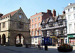 Shrewsbury Shrewsbury is the county town of Shropshire, in the West Midlands region of England. Lying on the River Severn, it is a civil parish home to some 70,000 inhabitants, and is the primary settlement and headquarters of Shropshire Council...  Oswestry Oswestry is a town and civil parish in Shropshire, England, close to the Welsh border. It is at the junction of the A5, A483, and A495 roads....  Bridgnorth Bridgnorth is a town in Shropshire, England, along the Severn Valley. It is split into Low Town and High Town, named on account of their elevations relative to the River Severn, which separates the upper town on the right bank from the lower on the left... |
Telford and Wrekin Telford and Wrekin Telford and Wrekin is a unitary district with borough status in the West Midlands region of England. For Eurostat purposes it is a NUTS 3 region and is one of four counties or unitary districts that comprise the "Shropshire and Staffordshire" NUTS 2 region. The district was created in 1974 as The... shown within 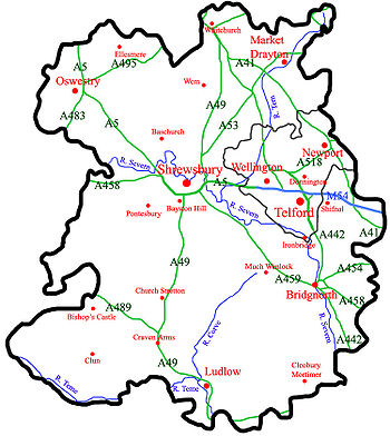 Rivers, Motorways, 'A' Roads Great Britain road numbering scheme The Great Britain road numbering scheme is a numbering scheme used to classify and identify all roads in Great Britain. Each road is given a single letter, which represents the road's category, and a subsequent number, with a length of between 1 and 4 digits. Originally introduced to arrange... , Settlements |
Towns (by population): Telford Telford Telford is a large new town in the borough of Telford and Wrekin and ceremonial county of Shropshire, England, approximately east of Shrewsbury, and west of Birmingham... (138,241) Shrewsbury Shrewsbury Shrewsbury is the county town of Shropshire, in the West Midlands region of England. Lying on the River Severn, it is a civil parish home to some 70,000 inhabitants, and is the primary settlement and headquarters of Shropshire Council... (70,560) Oswestry Oswestry Oswestry is a town and civil parish in Shropshire, England, close to the Welsh border. It is at the junction of the A5, A483, and A495 roads.... (15,613) Bridgnorth Bridgnorth Bridgnorth is a town in Shropshire, England, along the Severn Valley. It is split into Low Town and High Town, named on account of their elevations relative to the River Severn, which separates the upper town on the right bank from the lower on the left... (12,212) Newport Newport, Shropshire Newport is a market town in the borough of Telford and Wrekin and ceremonial county of Shropshire, England. It lies some north of Telford and some west of Stafford sitting on the Shropshire/Staffordshire border... (10,814) Ludlow Ludlow Ludlow is a market town in Shropshire, England close to the Welsh border and in the Welsh Marches. It lies within a bend of the River Teme, on its eastern bank, forming an area of and centred on a small hill. Atop this hill is the site of Ludlow Castle and the market place... (10,500) Market Drayton Market Drayton Market Drayton is a small market town in north Shropshire, England. It is on the River Tern, between Shrewsbury and Stoke-on-Trent, and was formerly known as "Drayton in Hales" and earlier simply as "Drayton" .... (10,407) Whitchurch Whitchurch, Shropshire Whitchurch is a market town in Shropshire, England on the border between England and Wales. It is the oldest continuously inhabited town in Shropshire. According to the 2001 Census, the population of the town is 8,673, with a more recent estimate putting the population of the town at 8,934... (8,907) Shifnal Shifnal Shifnal is a small market town in Shropshire, England. It forms part of The Wrekin constituency, and is about east of Telford. It has a railway station on the Shrewsbury-Wolverhampton Line and is near to the M54 motorway.-Early medieval time:... (7,094) Bayston Hill Bayston Hill Bayston Hill is a large village and civil parish in central Shropshire, England. It is south of the county town Shrewsbury and located on the main A49 road, the Shrewsbury to Hereford road.... (5,247) Wem Wem Wem is a small market town in Shropshire, England. It is the administrative centre for the northern area committee of Shropshire Council, which has its headquarters at Edinburgh House in the centre of Wem. Wem railway station is on the Shrewsbury to Crewe railway line... (5,142) Broseley Broseley Broseley is a small town in Shropshire, England with a population of 4,912 . The River Severn flows to the north and east of the town. Broseley has a town council and is part of the area controlled by Shropshire Council. The first iron bridge in the world was built in 1779 to link Broseley with... (4,912) Church Stretton Church Stretton Church Stretton is a small town and civil parish in Shropshire, England. The population of the town was recorded as 2,789 in 2001, whilst the population of the wider parish was recorded as 4,186... (4,186) Albrighton Albrighton, Bridgnorth Albrighton is a large village and civil parish in Shropshire, England. It is located to the northwest of Wolverhampton and is best described as a dormitory village for the city... (4,157) Pontesbury Pontesbury Pontesbury is a large village and civil parish in Shropshire and is approximately eight miles southwest of the county town of Shrewsbury. The village of Minsterley is just over a mile further southwest. The A488 road runs through the village, on its way from Shrewsbury to Bishop's Castle... (3, 500) Ellesmere Ellesmere, Shropshire Ellesmere is a small market town near Oswestry in north Shropshire, England, notable for its proximity to a number of prominent lakes, the Meres.-History:... (3,223) Much Wenlock Much Wenlock Much Wenlock, earlier known as Wenlock, is a small town in central Shropshire, England. It is situated on the A458 road between Shrewsbury and Bridgnorth. Nearby, to the northeast, is the Ironbridge Gorge, and the new town of Telford... (2,605) Craven Arms Craven Arms Craven Arms is a small town and civil parish in Shropshire, England, located on the A49 road and the Welsh Marches railway line, which connect it north and south to the larger towns of Shrewsbury and Ludlow respectively. The Heart of Wales railway line joins the Welsh Marches line at Craven Arms... (2,289) Prees Prees, Shropshire Prees is a village and civil parish in north Shropshire, near the border between England and Wales. Its name is Celtic and means "brushwood".... (2,688) Bishop's Castle Bishop's Castle Bishop's Castle is a small market town in Shropshire, England, and formerly its smallest borough. According to the 2001 census it had a population of 1,630. Bishop's Castle is east of the Wales-England border, about north-west of Ludlow and about south-west of Shrewsbury. To the south is Clun... (1,630) Ruyton-XI-Towns Ruyton-XI-Towns Ruyton-XI-Towns , formally Ruyton of the Eleven Towns or simply Ruyton, is a large village and civil parish in Shropshire, England. It has a population of around 1,500 people and lies on the River Perry. Nearby is the large village of Baschurch and to the north the smaller village of Wykey... (1,500) Baschurch Baschurch Baschurch is a large village and civil parish in Shropshire, England. It lies in North Shropshire, north of Shrewsbury. Population: 1,475 . The village has strong links to Shrewsbury to the south-east, Oswestry to the north-west, and Wem to the north-east. Baschurch is twinned with the town of Giat... (1,475) Clun Clun Clun is a small town in Shropshire, England. The town is located entirely in the Shropshire Hills Area of Outstanding Natural Beauty. The 2001 census recorded 642 people living in the town... (642) |
Newport, Shropshire Newport is a market town in the borough of Telford and Wrekin and ceremonial county of Shropshire, England. It lies some north of Telford and some west of Stafford sitting on the Shropshire/Staffordshire border... Ludlow Ludlow Ludlow is a market town in Shropshire, England close to the Welsh border and in the Welsh Marches. It lies within a bend of the River Teme, on its eastern bank, forming an area of and centred on a small hill. Atop this hill is the site of Ludlow Castle and the market place... Market Drayton Market Drayton Market Drayton is a small market town in north Shropshire, England. It is on the River Tern, between Shrewsbury and Stoke-on-Trent, and was formerly known as "Drayton in Hales" and earlier simply as "Drayton" .... Whitchurch Whitchurch, Shropshire Whitchurch is a market town in Shropshire, England on the border between England and Wales. It is the oldest continuously inhabited town in Shropshire. According to the 2001 Census, the population of the town is 8,673, with a more recent estimate putting the population of the town at 8,934... |
The town of Telford
Telford
Telford is a large new town in the borough of Telford and Wrekin and ceremonial county of Shropshire, England, approximately east of Shrewsbury, and west of Birmingham...
was created by the merger of older small towns surrounding the Wrekin. These towns now have sizeable populations that now make up the population of Telford, but still have unique characters, these are Wellington
Wellington, Shropshire
Wellington is a town in the unitary authority of Telford and Wrekin and ceremonial county of Shropshire, England and now forms part of the new town of Telford. The population of the parish of Wellington was recorded as 20,430 in the 2001 census, making it the third largest town in Shropshire if...
(20,430), Madeley
Madeley, Shropshire
Madeley is a town and civil parish in Shropshire, England, now part of the new town of Telford. The parish had a population of 17,935 at the 2001 census.Madeley is recorded in the Domesday Book, having been founded before the 8th century...
(17,935), Dawley
Dawley
Dawley is a small town in the borough of Telford and Wrekin and ceremonial county of Shropshire, England. Today it forms part of the new town of Telford...
(11,399) and Oakengates
Oakengates
Oakengates is a town in the borough of Telford and Wrekin and ceremonial county of Shropshire, England, and now forms part of the new town of Telford...
(8,517), but the Telford and Wrekin borough towns incentive aims to make Oakengates into the largest of the towns.
Politics
For EurostatEurostat
Eurostat is a Directorate-General of the European Commission located in Luxembourg. Its main responsibilities are to provide the European Union with statistical information at European level and to promote the integration of statistical methods across the Member States of the European Union,...
purposes, Shropshire County Council is a NUTS 3 region (code UKG22). The county has five parliamentary constituencies, four of which returned Conservative MPs at the 2005 general election and one, Telford, returned a Labour MP. This is a marked change from the 2001 general election result, where the county returned only one Conservative, three Labour and a Liberal Democrat to the Commons (see maps to the right) (Labour = Red, Conservatives = Blue and
Liberal Democrats = Orange).
The current MPs of Shropshire are:
- David WrightDavid Wright (politician)David Wright is a British Labour Party politician who has been the Member of Parliament for Telford since 2001. He was an assistant government whip from June 2009 to May 2010.-Early and personal life:...
, Labour, TelfordTelford (UK Parliament constituency)Telford is a parliamentary constituency represented in the House of Commons of the Parliament of the United Kingdom. It elects one Member of Parliament by the first past the post system of election.-Boundaries:...
(covering the town of TelfordTelfordTelford is a large new town in the borough of Telford and Wrekin and ceremonial county of Shropshire, England, approximately east of Shrewsbury, and west of Birmingham...
) - Owen PatersonOwen PatersonOwen William Paterson is a British Conservative Party politician and Secretary of State for Northern Ireland. He is the Member of Parliament for North Shropshire.-Early life and career:Paterson was born in Whitchurch, Shropshire...
, Conservative, North ShropshireNorth Shropshire (UK Parliament constituency)North Shropshire is a constituency represented in the House of Commons of the Parliament of the United Kingdom. From its first creation in 1832 to the abolition of the first creation in 1885 it elected two Knights of the Shire...
(covering the former North ShropshireNorth ShropshireNorth Shropshire was a local government district in Shropshire, England. The district council was based at Edinburgh House, in Wem. Other settlements included the towns of Ellesmere, Market Drayton, Wem and Whitchurch, as well as the large villages of Shawbury and Baschurch...
and OswestryOswestry (borough)Oswestry was a small local government district with borough status in Shropshire, England. It was the smallest of the five districts of Shropshire in terms of both population and land area....
districts, now coextensive with the North area committee) - Philip DunnePhilip Dunne (politician)Philip Martin Dunne is a British Conservative Party politician and the Member of Parliament for the Ludlow constituency in Shropshire....
, Conservative, LudlowLudlow (UK Parliament constituency)Ludlow is a county constituency represented in the House of Commons of the Parliament of the United Kingdom. It elects one Member of Parliament by the first past the post system of election....
(covering the former South ShropshireSouth ShropshireSouth Shropshire was, between 1974 and 2009, a local government district in south west Shropshire, England.South Shropshire was the most rural district of one of the UK's most rural counties, the population of the district was 40,410 in 2001 spread out over 1,027 km² of forest, mountains,...
and (the majority of) Bridgnorth districts; now coextensive with the South area committee except for the part covered by the Wrekin constituency) - Daniel KawczynskiDaniel KawczynskiDaniel Robert Kawczynski is the Conservative Party Member for Parliament for Shrewsbury and Atcham in Shropshire, England.-Biography:...
, Conservative, Shrewsbury and AtchamShrewsbury and Atcham (UK Parliament constituency)Shrewsbury and Atcham is a parliamentary constituency represented in the House of Commons of the Parliament of the United Kingdom. It elects one Member of Parliament by the first past the post system of election....
(covering the former Shrewsbury and AtchamShrewsbury and AtchamShrewsbury and Atcham was, between 1974 and 2009, a local government district with borough status in Shropshire, England.Shrewsbury was the only town in the borough; Atcham, although itself only a village, was included in the name as a reflection of the incorporation into the borough of the former...
district; now coextensive with the Central area committee) - Mark Pritchard, Conservative, The WrekinThe Wrekin (UK Parliament constituency)The Wrekin is a county constituency represented in the House of Commons of the Parliament of the United Kingdom since 1918. It elects one Member of Parliament by the first past the post system of election...
(covering Telford and WrekinTelford and WrekinTelford and Wrekin is a unitary district with borough status in the West Midlands region of England. For Eurostat purposes it is a NUTS 3 region and is one of four counties or unitary districts that comprise the "Shropshire and Staffordshire" NUTS 2 region. The district was created in 1974 as The...
borough, minus Telford, and including a small area of the former Bridgnorth district/South area committee)
In 2005 there was also a County Council election in which the Conservatives gained overall control of the shire county. Telford and Wrekin Borough Council remained at the time under Labour control but has since gone to no-overall control, with a Conservative executive. Being a rural county, there are a number of independent councillors on the various councils in the county.
The Conservatives gained complete control of Shrewsbury and Atcham Borough Council in the May 2006 local elections.
| Constituency | 1992 | 1997 | 2001 | 2005 | 2010 |
|---|---|---|---|---|---|
| Ludlow | Christopher Gill | Matthew Green | Philip Dunne | ||
| North Shropshire | John Biffen | Owen Paterson | |||
| Shrewsbury & Atcham | Derek Conway | Paul Marsden | Paul Marsden | Daniel Kawczynski | |
| Telford | Bruce Grocott* | Bruce Grocott | David Wright | ||
| The Wrekin | Peter Bradley | Mark Pritchard | |||
- Note (*), The Wrekin (historic UK Parliament constituency) was split at the 1997 election.
Divisions and environs
Most of the ceremonial countyCeremonial counties of England
The ceremonial counties are areas of England to which are appointed a Lord Lieutenant, and are defined by the government as counties and areas for the purposes of the Lieutenancies Act 1997 with reference to the metropolitan and non-metropolitan counties of England and Lieutenancies Act 1997...
of Shropshire is covered for purposes of local government by Shropshire Council
Shropshire Council
Shropshire Council is a unitary authority in Shropshire, United Kingdom.It replaced the former two-tier local government structure in the non-metropolitan county of Shropshire on 1 April 2009, which involved its immediate predecessor, Shropshire County Council, and five non-metropolitan districts -...
, a unitary authority
Unitary authority
A unitary authority is a type of local authority that has a single tier and is responsible for all local government functions within its area or performs additional functions which elsewhere in the relevant country are usually performed by national government or a higher level of sub-national...
established in 2009. Telford and Wrekin
Telford and Wrekin
Telford and Wrekin is a unitary district with borough status in the West Midlands region of England. For Eurostat purposes it is a NUTS 3 region and is one of four counties or unitary districts that comprise the "Shropshire and Staffordshire" NUTS 2 region. The district was created in 1974 as The...
is a unitary authority, with borough
Borough
A borough is an administrative division in various countries. In principle, the term borough designates a self-governing township although, in practice, official use of the term varies widely....
status, which forms part of the county for various functions such as Lord Lieutenant
Lord Lieutenant
The title Lord Lieutenant is given to the British monarch's personal representatives in the United Kingdom, usually in a county or similar circumscription, with varying tasks throughout history. Usually a retired local notable, senior military officer, peer or business person is given the post...
but is a separate local authority from Shropshire Council. However many services are shared across both authorities, such as the fire and rescue service
Shropshire Fire and Rescue Service
The Shropshire Fire and Rescue Service is the statutory fire and rescue service covering Shropshire, including Telford and Wrekin, in the West Midlands region of England....
, and the two authorities co-operate on some projects such as mapping flood risk.
The ceremonial county borders Cheshire
Cheshire
Cheshire is a ceremonial county in North West England. Cheshire's county town is the city of Chester, although its largest town is Warrington. Other major towns include Widnes, Congleton, Crewe, Ellesmere Port, Runcorn, Macclesfield, Winsford, Northwich, and Wilmslow...
, Staffordshire, Worcestershire, Herefordshire
Herefordshire
Herefordshire is a historic and ceremonial county in the West Midlands region of England. For Eurostat purposes it is a NUTS 3 region and is one of three counties that comprise the "Herefordshire, Worcestershire and Gloucestershire" NUTS 2 region. It also forms a unitary district known as the...
, and the Welsh preserved counties
Preserved counties of Wales
The preserved counties of Wales are the current areas used in Wales for the ceremonial purposes of Lieutenancy and Shrievalty. They are based on the counties created by the Local Government Act 1972 and used for local government and other purposes between 1974 and 1996.-Usage:The Local Government ...
of Powys
Powys
Powys is a local-government county and preserved county in Wales.-Geography:Powys covers the historic counties of Montgomeryshire and Radnorshire, most of Brecknockshire , and a small part of Denbighshire — an area of 5,179 km², making it the largest county in Wales by land area.It is...
and Clwyd
Clwyd
Clwyd is a preserved county of Wales, situated in the north-east, bordering England with Cheshire to its east, Shropshire to the south-east, and the Welsh counties of Gwynedd to its immediate west and Powys to the south. It additionally shares a maritime border with the metropolitan county of...
.
The new unitary authority for Shropshire, Shropshire Council
Shropshire Council
Shropshire Council is a unitary authority in Shropshire, United Kingdom.It replaced the former two-tier local government structure in the non-metropolitan county of Shropshire on 1 April 2009, which involved its immediate predecessor, Shropshire County Council, and five non-metropolitan districts -...
, divides the county into three areas, each with its own area committee
Area committee
Many large local government councils in the United Kingdom have a system of area committees, with responsibility for services in a particular part of the area covered by the council....
– North, Central and South. These area committees, as well as relative staff, deal with local matters such as development control and licensing.
With the parishing of the formerly unparished area
Unparished area
In England, an unparished area is an area that is not covered by a civil parish. Most urbanised districts of England are either entirely or partly unparished. Many towns and some cities in otherwise rural districts are also unparished areas and therefore no longer have a town council or city...
of Shrewsbury in 2008, the entire ceremonial county is now parished. The sizes of parishes varies enormously in terms of area covered and population resident. Shrewsbury is the most populous parish in the county (and one of the most populous in England) with over 70,000 residents, whilst Boscobel
Boscobel
Boscobel is a very small civil parish in the east of Shropshire, England, on the border with Staffordshire. To the north is the Staffordshire village of Bishops Wood....
is the smallest parish in Shropshire by geographical area and by population, with just 12 residents according to the 2001 census. The smaller parishes (with populations of less than 200) usually have a joint parish council with one or more neighbouring parishes, or in some instances, have a parish meeting
Parish meeting
A parish meeting, in England, is a meeting to which all the electors in a civil parish are entitled to attend. In some cases, where a parish or group of parishes has fewer than 200 electors, the parish meeting can take on the role of the parish council itself, with statutory powers, and electing a...
(such as in Sibdon Carwood
Sibdon Carwood
Sibdon Carwood is a hamlet and small parish in Shropshire, England. To its east is the small market town of Craven Arms.-The hamlet:The community is quite dispersed, though there is a core hamlet at the heart of the Sibdon Castle estate...
). The urban area of Telford is divided into many parishes, each covering a particular suburb, some of which are historic villages or towns (such as Madeley
Madeley, Shropshire
Madeley is a town and civil parish in Shropshire, England, now part of the new town of Telford. The parish had a population of 17,935 at the 2001 census.Madeley is recorded in the Domesday Book, having been founded before the 8th century...
). The parish remains an important sub-division and tier of local government in both unitary authority areas of Shropshire.
Local government 1974–2009
County council
A county council is the elected administrative body governing an area known as a county. This term has slightly different meanings in different countries.-United Kingdom:...
(as the upper tier) and six district
Non-metropolitan district
Non-metropolitan districts, or colloquially shire districts, are a type of local government district in England. As created, they are sub-divisions of non-metropolitan counties in a so-called "two-tier" arrangement...
councils – Bridgnorth
Bridgnorth (district)
Bridgnorth District was, between 1974 and 2009, a local government district in Shropshire, England. Its main town was Bridgnorth and other towns in its area were Much Wenlock, Shifnal and Broseley. The villages of Albrighton and Sheriffhales as well as RAF Cosford were also in the district.The...
, North Shropshire
North Shropshire
North Shropshire was a local government district in Shropshire, England. The district council was based at Edinburgh House, in Wem. Other settlements included the towns of Ellesmere, Market Drayton, Wem and Whitchurch, as well as the large villages of Shawbury and Baschurch...
, Oswestry
Oswestry (borough)
Oswestry was a small local government district with borough status in Shropshire, England. It was the smallest of the five districts of Shropshire in terms of both population and land area....
, Shrewsbury and Atcham
Shrewsbury and Atcham
Shrewsbury and Atcham was, between 1974 and 2009, a local government district with borough status in Shropshire, England.Shrewsbury was the only town in the borough; Atcham, although itself only a village, was included in the name as a reflection of the incorporation into the borough of the former...
, South Shropshire
South Shropshire
South Shropshire was, between 1974 and 2009, a local government district in south west Shropshire, England.South Shropshire was the most rural district of one of the UK's most rural counties, the population of the district was 40,410 in 2001 spread out over 1,027 km² of forest, mountains,...
and The Wrekin
Telford and Wrekin
Telford and Wrekin is a unitary district with borough status in the West Midlands region of England. For Eurostat purposes it is a NUTS 3 region and is one of four counties or unitary districts that comprise the "Shropshire and Staffordshire" NUTS 2 region. The district was created in 1974 as The...
. In 1998 The Wrekin became a unitary authority
Unitary authority
A unitary authority is a type of local authority that has a single tier and is responsible for all local government functions within its area or performs additional functions which elsewhere in the relevant country are usually performed by national government or a higher level of sub-national...
, administratively separate from the county council, and became Telford and Wrekin. The two-tier structure remained in the remainder of the county and was the least populated two-tier area in England.
Oswestry and Shrewsbury & Atcham were each granted borough
Borough
A borough is an administrative division in various countries. In principle, the term borough designates a self-governing township although, in practice, official use of the term varies widely....
status in 1974. Telford and Wrekin became a borough in 2002.
2009 restructuring
In 2006 a local government white paper supported proposals for new unitary authoritiesUnitary authority
A unitary authority is a type of local authority that has a single tier and is responsible for all local government functions within its area or performs additional functions which elsewhere in the relevant country are usually performed by national government or a higher level of sub-national...
to be set up in England in certain areas. Existing non-metropolitan counties with small populations, such as Cornwall
Cornwall
Cornwall is a unitary authority and ceremonial county of England, within the United Kingdom. It is bordered to the north and west by the Celtic Sea, to the south by the English Channel, and to the east by the county of Devon, over the River Tamar. Cornwall has a population of , and covers an area of...
, Northumberland and Shropshire, were favoured by the government to be covered by unitary authorities in one form or another (the county either becoming a single unitary authority, or be broken into a number of unitary authorities). For the counties in the 2009 reorganisation, existing unitary authority areas within the counties' ceremonial boundaries
Ceremonial counties of England
The ceremonial counties are areas of England to which are appointed a Lord Lieutenant, and are defined by the government as counties and areas for the purposes of the Lieutenancies Act 1997 with reference to the metropolitan and non-metropolitan counties of England and Lieutenancies Act 1997...
(such as Telford and Wrekin) were not to be affected and no boundary changes were planned.
Shropshire County Council, supported by South Shropshire District Council and Oswestry Borough Council, proposed to the government that the non-metropolitan county of Shropshire become a single unitary authority. This was opposed by the other 3 districts in the county, with Shrewsbury & Atcham Borough Council taking their objection to the High Court in a judicial review.
The proposal to create a Shropshire unitary authority, covering the area of the existing non-metropolitan county, was supported by the DCLG and 1 April 2009 was set as the date for the re-organisation to take place. The first elections to Shropshire Council will not take place however until 4 June 2009, with the former Shropshire County Council being the continuing authority and its councillors became the first members of the new Shropshire Council on 1 April.
Part of the proposals include parishing
Civil parish
In England, a civil parish is a territorial designation and, where they are found, the lowest tier of local government below districts and counties...
and establishing a town council
Town council
A town council is a democratically elected form of government for small municipalities or civil parishes. A council may serve as both the representative and executive branch....
for Shrewsbury. The parish was created on 13 May 2008 and is the second most populous civil parish in England (only Weston-super-Mare
Weston-super-Mare
Weston-super-Mare is a seaside resort, town and civil parish in the unitary authority of North Somerset, which is within the ceremonial county of Somerset, England. It is located on the Bristol Channel coast, south west of Bristol, spanning the coast between the bounding high ground of Worlebury...
has a greater population) with a population of over 70,000.
Transport
Shropshire is connected to the rest of the United Kingdom via a number of road and rail links. Historically, rivers and later canals in the county were used for transport also, although their use in transport is now significantly reduced. The county's main transportation hub is Shrewsbury, through which many significant roads and railways pass and join.
Canals in the United Kingdom
Canals of the United Kingdom
The canals of the United Kingdom are a major part of the network of inland waterways in the United Kingdom. They have a colourful history, from use for irrigation and transport, through becoming the focus of the Industrial Revolution, to today's role for recreational boating...
today serve primarily for leisure purposes and three British Waterways
British Waterways
British Waterways is a statutory corporation wholly owned by the government of the United Kingdom, serving as the navigation authority in England, Scotland and Wales for the vast majority of the canals as well as a number of rivers and docks...
canals run through Shropshire: the Shropshire Union Canal
Shropshire Union Canal
The Shropshire Union Canal is a navigable canal in England; the Llangollen and Montgomery canals are the modern names of branches of the Shropshire Union system and lie partially in Wales....
(from north of Adderley
Adderley
Adderley is a village and civil parish in the English county of Shropshire, several kilometres north of Market Drayton. It is known as Eldredelei in the Domesday Book...
to near Knighton), the Llangollen Canal
Llangollen Canal
The Llangollen Canal is a navigable canal crossing the border between England and Wales. The waterway links Llangollen in Denbighshire, north Wales, with Hurleston in south Cheshire, via the town of Ellesmere, Shropshire....
(from Chirk Aqueduct
Chirk Aqueduct
Chirk Aqueduct is a high and long navigable aqueduct that carries what is now the Llangollen Canal across the Ceiriog Valley near Chirk, on the England-Wales border....
to Grindley Brook
Grindley Brook
Grindley Brook is a small village in Shropshire, England, on the A41 trunk road around 1.5 miles north west of the market town of Whitchurch. It is the most northerly settlement in Shropshire and borders directly onto Cheshire, and is within the civil parish of Whitchurch Rural.It is also the name...
) and the Montgomery Canal
Montgomery Canal
The Montgomery Canal , known colloquially as "The Monty", is a partially restored canal in Powys, in eastern Wales, and in northwest Shropshire, in western England...
(from its beginning at Frankton Junction
Frankton Junction
Frankton Junction is the name of the canal junction where the Montgomery Canal terminates and meets the Llangollen Canal at Lower Frankton, Shropshire, England.-Bridge numbering:...
to Llanymynech
Llanymynech
Llanymynech is a village straddling the border between Montgomeryshire/Powys, Wales and Shropshire, England about 9 miles north of the Welsh town of Welshpool. The name is Welsh for "Church of the Monks"....
). In addition, the Shrewsbury and Newport Canal
Shrewsbury Canal
The Shrewsbury Canal was a canal in Shropshire, England. Authorised in 1793, the main line from Trench to Shrewsbury was fully open by 1797, but it remained isolated from the rest of the canal network until 1835, when the Birmingham and Liverpool Junction Canal built the Newport Branch from...
potentially could be restored in the
future.
Major roads in the county include the M54 motorway
M54 motorway
The M54 is a 23 mile east-west motorway in the English counties of Shropshire and Staffordshire. It is also referred to as the Telford Motorway, after the road's primary westbound destination, the new town of Telford...
, which connects Shropshire to the rest of the motorway network, and more specifically to the West Midlands county. The A5 also runs through the county, in an east-west direction. The road formerly ran through Shrewsbury, although a large dual-carriageway bypass has since been built. Other major trunk roads in the county include the north-south A49
A49 road
The A49 is a major road in western England, which traverses the Welsh Marches region. It runs north from Ross-on-Wye in Herefordshire via Hereford, Leominster, Ludlow, Shrewsbury and Whitchurch, then continues through central Cheshire to Warrington and Wigan before terminating at its junction with...
, the A53
A53 road
The A53 is a primary route in northern England, that runs from Buxton in Derbyshire to Shrewsbury in Shropshire.-Route of Road:The A53 begins in the centre of Buxton off the A6 road, before meeting the A515 road at a roundabout. Out of the town, it has a junction with the A54 road before...
and the A41
A41 road
The A41 is a formerly-major trunk road in England that links London and Birkenhead, although it has now largely been superseded by motorways. It passes through or near various towns and cities including Watford, Hemel Hempstead, Aylesbury, Solihull, Birmingham, West Bromwich, Wolverhampton,...
.
There are a number of major railway
Railways of Shropshire
The English county of Shropshire has a fairly large railway network, with 19 National Rail stations on various national lines, as well as a small number of heritage and freight lines, including the famous heritage Severn Valley Railway running along its eastern border with Worcestershire.The...
lines running through the county, including the Welsh Marches Line
Welsh Marches Line
The Welsh Marches Line , known historically as the North and West Route, is the railway line running from Newport in south-east Wales to Shrewsbury in the West Midlands region of England by way of Abergavenny, Hereford and Craven Arms, and thence to Crewe via Whitchurch...
, the Cambrian Line
Cambrian Line
The Cambrian Line is a railway from Shrewsbury to Welshpool, Aberystwyth and Pwllheli. The railway runs first through the central part of Wales and then along the coast of Cardigan Bay....
, the Shrewsbury to Chester Line
Shrewsbury to Chester Line
The Shrewsbury to Chester Line, also known as the Severn–Dee Line , was built in 1846 as the Shrewsbury and Chester Railway...
and the Wolverhampton to Shrewsbury Line
Wolverhampton to Shrewsbury Line
The Wolverhampton to Shrewsbury Line is the railway line from Wolverhampton to Shrewsbury via Wellington; it was originally built by the Shrewsbury and Birmingham Railway. The line is double track throughout, with rarely used relief sidings at Cosford and 4 tracks through Wellington station...
, as well as heritage railway
Heritage railway
thumb|right|the Historical [[Khyber train safari|Khyber Railway]] goes through the [[Khyber Pass]], [[Pakistan]]A heritage railway , preserved railway , tourist railway , or tourist railroad is a railway that is run as a tourist attraction, in some cases by volunteers, and...
s including the well established Severn Valley Railway
Severn Valley Railway
The Severn Valley Railway is a heritage railway in Shropshire and Worcestershire, England. The line runs along the Severn Valley from Bridgnorth to Kidderminster, following the course of the River Severn for much of its route...
. The two train operating companies working in the county are London Midland
London Midland
London Midland is a train operating company in the United Kingdom. Legally named London and Birmingham Railway Ltd, it is a subsidiary of Govia, and has operated the West Midlands franchise since 11 November 2007....
and Arriva Trains Wales
Arriva Trains Wales
Arriva Trains Wales is a train operating company, owned by Arriva, that operates urban and inter urban passenger services in Wales and the Welsh Marches...
. A new company, Wrexham & Shropshire, commenced services from Shropshire to London Marylebone station
Marylebone station
Marylebone station , also known as London Marylebone, is a central London railway terminus and London Underground complex. It stands midway between the mainline stations at Euston and Paddington, about 1 mile from each...
, in spring 2008 but the service was discontinued on 28 January 2011 leaving Shrewsbury without a direct link to the capital.
Two major water supply aqueduct
Aqueduct
An aqueduct is a water supply or navigable channel constructed to convey water. In modern engineering, the term is used for any system of pipes, ditches, canals, tunnels, and other structures used for this purpose....
s run across Shropshire; the Elan aqueduct
Elan aqueduct
The Elan aqueduct, crosses Wales and the Midlands of England, running eastwards from the Elan Valley Reservoirs in Powys to Birmingham's Frankley Reservoir, carrying drinking water for Birmingham....
running through South Shropshire carrying water from Elan Valley
Elan Valley
The Elan Valley is a river valley situated to the west of Rhayader, in Powys, Wales, sometimes known as the "Welsh Lake District". It covers of lake and countryside....
to Birmingham
Birmingham
Birmingham is a city and metropolitan borough in the West Midlands of England. It is the most populous British city outside the capital London, with a population of 1,036,900 , and lies at the heart of the West Midlands conurbation, the second most populous urban area in the United Kingdom with a...
and the Vyrnwy Aqueduct running through North Shropshire delivering water from Lake Vyrnwy
Lake Vyrnwy
Lake Vyrnwy Nature Reserve and Estate is an area of land in Montgomeryshire, Powys, Wales, surrounding the Victorian reservoir of Lake Vyrnwy. Its stone-built dam, built in the 1880s, was the first of its kind in the world. The Nature Reserve and the area around it are jointly managed by the Royal...
to Liverpool
Liverpool
Liverpool is a city and metropolitan borough of Merseyside, England, along the eastern side of the Mersey Estuary. It was founded as a borough in 1207 and was granted city status in 1880...
.
Economy
Shrewsbury
Shrewsbury is the county town of Shropshire, in the West Midlands region of England. Lying on the River Severn, it is a civil parish home to some 70,000 inhabitants, and is the primary settlement and headquarters of Shropshire Council...
, the historic castle-dominated Ludlow
Ludlow
Ludlow is a market town in Shropshire, England close to the Welsh border and in the Welsh Marches. It lies within a bend of the River Teme, on its eastern bank, forming an area of and centred on a small hill. Atop this hill is the site of Ludlow Castle and the market place...
, the International Olympic Movement's birthplace Much Wenlock
Much Wenlock
Much Wenlock, earlier known as Wenlock, is a small town in central Shropshire, England. It is situated on the A458 road between Shrewsbury and Bridgnorth. Nearby, to the northeast, is the Ironbridge Gorge, and the new town of Telford...
and the industrial birthplace of Ironbridge Gorge
Ironbridge Gorge
The Ironbridge Gorge is a deep gorge formed by the River Severn in Shropshire, England.Originally called the Severn Gorge, the gorge now takes its name from its famous Iron Bridge, the first iron bridge of its kind in the world, and a monument to the industry that began there...
are the foremost tourist areas in Shropshire, along with the reclaimed canal network which provides canal barge holidays on the Shropshire Union Canal
Shropshire Union Canal
The Shropshire Union Canal is a navigable canal in England; the Llangollen and Montgomery canals are the modern names of branches of the Shropshire Union system and lie partially in Wales....
and linked canal networks in the region, although the natural beauty of the county draws people to all areas.
Industry is mostly found in Telford
Telford
Telford is a large new town in the borough of Telford and Wrekin and ceremonial county of Shropshire, England, approximately east of Shrewsbury, and west of Birmingham...
, Oswestry
Oswestry
Oswestry is a town and civil parish in Shropshire, England, close to the Welsh border. It is at the junction of the A5, A483, and A495 roads....
, Whitchurch
Whitchurch, Shropshire
Whitchurch is a market town in Shropshire, England on the border between England and Wales. It is the oldest continuously inhabited town in Shropshire. According to the 2001 Census, the population of the town is 8,673, with a more recent estimate putting the population of the town at 8,934...
, Market Drayton
Market Drayton
Market Drayton is a small market town in north Shropshire, England. It is on the River Tern, between Shrewsbury and Stoke-on-Trent, and was formerly known as "Drayton in Hales" and earlier simply as "Drayton" ....
and Shrewsbury, though small industrial estates can be found in and Church Stretton
Church Stretton
Church Stretton is a small town and civil parish in Shropshire, England. The population of the town was recorded as 2,789 in 2001, whilst the population of the wider parish was recorded as 4,186...
and Newport
Newport, Shropshire
Newport is a market town in the borough of Telford and Wrekin and ceremonial county of Shropshire, England. It lies some north of Telford and some west of Stafford sitting on the Shropshire/Staffordshire border...
where the main industrial factory Audco, closed in 1982. The town has then started to move more towards an agricultural and tourist industry much like Ludlow
Ludlow
Ludlow is a market town in Shropshire, England close to the Welsh border and in the Welsh Marches. It lies within a bend of the River Teme, on its eastern bank, forming an area of and centred on a small hill. Atop this hill is the site of Ludlow Castle and the market place...
, though industry is starting to build up along the outskirts of the town on the A41 road
A41 road
The A41 is a formerly-major trunk road in England that links London and Birkenhead, although it has now largely been superseded by motorways. It passes through or near various towns and cities including Watford, Hemel Hempstead, Aylesbury, Solihull, Birmingham, West Bromwich, Wolverhampton,...
, because of its possession on the route between Wolverhampton
Wolverhampton
Wolverhampton is a city and metropolitan borough in the West Midlands, England. For Eurostat purposes Walsall and Wolverhampton is a NUTS 3 region and is one of five boroughs or unitary districts that comprise the "West Midlands" NUTS 2 region...
, Birmingham, Staffordshire and the north. Shrewsbury is becoming a centre for distribution and warehousing, as it is located on a nodal point of the regional road network.
In Telford, a new rail freight facility has been built at Donnington
Donnington, Telford
Donnington was not part of the new town of Telford but part of the already oudated Wellington Rural District which had built many council houses from the 1920s onwards. It is located in the borough of Telford and Wrekin and ceremonial county of Shropshire, England...
with the future goal of extending the line to Stafford
Stafford
Stafford is the county town of Staffordshire, in the West Midlands region of England. It lies approximately north of Wolverhampton and south of Stoke-on-Trent, adjacent to the M6 motorway Junction 13 to Junction 14...
, this is hoped it would open the freight terminal up to the East Midlands
East Midlands
The East Midlands is one of the regions of England, consisting of most of the eastern half of the traditional region of the Midlands. It encompasses the combined area of Nottinghamshire, Derbyshire, Leicestershire, Rutland, Northamptonshire and most of Lincolnshire...
and the north, plus also re-connect Newport
Newport, Shropshire
Newport is a market town in the borough of Telford and Wrekin and ceremonial county of Shropshire, England. It lies some north of Telford and some west of Stafford sitting on the Shropshire/Staffordshire border...
to the rail network.
Telford and Shrewsbury are the county's two main retail centres, with contrasting styles of shopping – Shrewsbury's largely historic streets and Telford's large modern mall, Telford Shopping Centre
Telford Shopping Centre
Telford Shopping Centre is a indoor super-regional shopping centre in Telford, Shropshire, England. It is located in the geographical and economic centre of the new town, on land which was previously undeveloped. It is the largest shopping area in the ceremonial county of Shropshire, being located...
. Shrewsbury also has two medium-sized shopping centres, the indoor "Pride Hill" and "Darwin
Darwin Shopping Centre
The Darwin Shopping Centre is the largest of the three main shopping centres in Shrewsbury, the county town of Shropshire, England, comprising approximately 17 per cent of the town centre's retail offer by leasable area....
" centres (both located on Pride Hill), and a smaller, partially covered, "Riverside Mall". Shrewsbury's situation of being the nearest substantial town for those in a large area of mid-Wales
Powys
Powys is a local-government county and preserved county in Wales.-Geography:Powys covers the historic counties of Montgomeryshire and Radnorshire, most of Brecknockshire , and a small part of Denbighshire — an area of 5,179 km², making it the largest county in Wales by land area.It is...
helps it draw in considerable numbers of shoppers, notably on Saturday.
Well-known companies in Shropshire include Müller Dairy (UK) Ltd
Müller (company)
Unternehmensgruppe Theo Müller is a multinational producer of dairy products, with a headquarters in Fischach in the German state of Bavaria. The group includes a number of companies operating under the Müller name, including the original Molkerei Alois Müller GmbH & Co. KG and Müller Dairy ...
in Market Drayton
Market Drayton
Market Drayton is a small market town in north Shropshire, England. It is on the River Tern, between Shrewsbury and Stoke-on-Trent, and was formerly known as "Drayton in Hales" and earlier simply as "Drayton" ....
. The RAF have two bases at RAF Cosford and RAF Shawbury
RAF Shawbury
RAF Shawbury is a Royal Air Force station by the village of Shawbury near Shrewsbury, Shropshire.The station at Shawbury was first used for military flying training in 1917 by the Royal Flying Corps, but it was returned to agricultural use in 1920. In 1938 it was reactivated as a training...
, and the charity PDSA
PDSA
The People's Dispensary for Sick Animals is a veterinary charity in the United Kingdom. It was founded in 1917 by Maria Dickin to provide care for sick and injured animals of the poor...
has its head office in Priorslee
St George's and Priorslee
St.George's and Priorslee are suburbs of the new town of Telford in Shropshire, England. The area is also a civil parish in the borough of Telford and Wrekin.The area lies North-East of the town centre of Telford and East of Oakengates...
, Telford.
Statistics
Below is the chart of regional gross value added for the non-metropolitan county (that is, excluding Telford & Wrekin) of Shropshire at current basic prices published (pp. 240–253) by Office for National Statistics with figures in millions of British pounds sterlingPound sterling
The pound sterling , commonly called the pound, is the official currency of the United Kingdom, its Crown Dependencies and the British Overseas Territories of South Georgia and the South Sandwich Islands, British Antarctic Territory and Tristan da Cunha. It is subdivided into 100 pence...
.
| Year | Regional Gross Value Added | Agriculture | Industry | Services |
|---|---|---|---|---|
| 1995 | 2,388 | 238 | 618 | 1,533 |
| 2000 | 2,977 | 177 | 739 | 2,061 |
| 2003 | 3,577 | 197 | 843 | 2,538 |
With the statistics for the borough of Telford and Wrekin
Telford and Wrekin
Telford and Wrekin is a unitary district with borough status in the West Midlands region of England. For Eurostat purposes it is a NUTS 3 region and is one of four counties or unitary districts that comprise the "Shropshire and Staffordshire" NUTS 2 region. The district was created in 1974 as The...
included, the following represents the ceremonial county:
| Year | Regional Gross Value Added | Agriculture | Industry | Services |
|---|---|---|---|---|
| 1995 | 4,151 | 266 | 1,483 | 2,403 |
| 2000 | 5,049 | 197 | 1,512 | 3,340 |
| 2003 | 5,947 | 218 | 1,693 | 4,038 |
Education
Shropshire has a completely comprehensive education system, in the ceremonial county there are thirteen independent schools, including the prestigious Shrewsbury SchoolShrewsbury School
Shrewsbury School is a co-educational independent school for pupils aged 13 to 18, founded by Royal Charter in 1552. The present campus to which the school moved in 1882 is located on the banks of the River Severn in Shrewsbury, Shropshire, England...
, which Charles Darwin
Charles Darwin
Charles Robert Darwin FRS was an English naturalist. He established that all species of life have descended over time from common ancestry, and proposed the scientific theory that this branching pattern of evolution resulted from a process that he called natural selection.He published his theory...
attended and Oswestry School
Oswestry School
Oswestry School is a co-educational independent school, located in the town of Oswestry, Shropshire, England. Founded in 1407 by David Holbache and his wife Guinevere Holbache, it is the second oldest non-denominational school in England....
, which is the second oldest school in the country, founded in 1407.
In the Borough of Telford and Wrekin borough has two selective schools, all of which are located in Newport
Newport, Shropshire
Newport is a market town in the borough of Telford and Wrekin and ceremonial county of Shropshire, England. It lies some north of Telford and some west of Stafford sitting on the Shropshire/Staffordshire border...
, these are the Adams' Grammar School
Adams' Grammar School
Adams' Grammar School is a selective state grammar school in Newport, Shropshire, rated by the Office for Standards in Education, Children's Services and Skills as a Grade 1 outstanding school , the latest OFSTED report concludes "this is a truly impressive school"...
and Newport Girls' High School (both of which are ranked within the top thirty schools in the country), and the independent preparatory school
Preparatory school (UK)
In English language usage in the former British Empire, the present-day Commonwealth, a preparatory school is an independent school preparing children up to the age of eleven or thirteen for entry into fee-paying, secondary independent schools, some of which are known as public schools...
Castle House, in Telford itself is the Thomas Telford School
Thomas Telford School
Thomas Telford School is a City Technology College in Telford, Shropshire, England. Often referred to as 'TTS', it achieved the highest GCSE pass rate of any comprehensive school in England in 2008 and 2009.-Background:...
is also a notable school, ranked as one of the best comprehensive schools in England.
There is considerable rivalry between many of the county's schools. In Shrewsbury for example, the Priory and Meole Brace schools maintain a long-standing sporting rivalry whilst on a wider scale Wrekin College
Wrekin College
Wrekin College is a co-educational independent school located in Wellington, Shropshire, England. It was founded by Sir John Bayley in 1880 and was known as ‘The School in the Garden’ owing to its extensive gardens and playing fields...
and Ellesmere College
Ellesmere College
Ellesmere College is an independent co-educational English independent school located in Ellesmere and based in rural northern Shropshire, England.-History:...
remain rivals, as do Shrewsbury School and Adams' Grammar School.
There are also two institutions of higher education in Shropshire, the Telford campus of Wolverhampton University and in Edgmond, near Newport, Harper Adams University College
Harper Adams University College
Harper Adams University College is a higher education institution located close to the village of Edgmond , in Shropshire, England. It is the UK's leading specialist provider of higher education for the agri-food chain and rural sector....
, which formerly offered mostly agriculture-based degrees but is expanding its range of provision.
In Ironbridge, the University of Birmingham
University of Birmingham
The University of Birmingham is a British Redbrick university located in the city of Birmingham, England. It received its royal charter in 1900 as a successor to Birmingham Medical School and Mason Science College . Birmingham was the first Redbrick university to gain a charter and thus...
operates the Ironbridge Institute
Ironbridge Institute
The Ironbridge Institute is a centre offering postgraduate and professional development courses in heritage and is a partnership between the University of Birmingham and the Ironbridge Gorge Museum Trust. It is located just outside Ironbridge in Coalbrookdale near Telford, Shropshire, in the United...
in partnership with the Ironbridge Gorge Museum Trust
Ironbridge Gorge Museum Trust
Ironbridge Gorge Museum Trust is an industrial heritage organisation which runs ten museums and manages 35 historic sites within the Ironbridge Gorge in Shropshire, England, widely considered as the birthplace of the Industrial Revolution....
, which offers postgraduate and professional development courses in heritage.
Shropshire has the highest educational attainment in the West Midlands region.
Places of interest
- AdcoteAdcoteAdcote School is an independent non-selective day and boarding school for girls, located in the village of Little Ness, five miles northwest of Shrewsbury, Shropshire, England. The school was founded in 1907, and is set in a Grade I listed country house built in 1879 for Rebecca Darby, the widow...
nr.ShrewsburyShrewsburyShrewsbury is the county town of Shropshire, in the West Midlands region of England. Lying on the River Severn, it is a civil parish home to some 70,000 inhabitants, and is the primary settlement and headquarters of Shropshire Council... - Aqualate HallAqualate HallAqualate Hall a 20th century country house, is located in Staffordshire, England, some 3.5 km east of the market town of Newport, Shropshire and 17 km west of the County town of Stafford...
, NewportNewport, ShropshireNewport is a market town in the borough of Telford and Wrekin and ceremonial county of Shropshire, England. It lies some north of Telford and some west of Stafford sitting on the Shropshire/Staffordshire border... - Attingham ParkAttingham ParkAttingham Park is a country house in Shropshire, England, which is owned by the National Trust. It is a Grade I listed building.- Location :It is located near to the village of Atcham, on the B4380 Shrewsbury to Wellington road.- History :...
, AtchamAtchamAtcham is a village, ecclesiastical parish and civil parish in Shropshire, England. It is situated on the B4380 , 5 miles south east of Shrewsbury. The River Severn flows around the village... - Benthall HallBenthall HallBenthall Hall is a 16th century English country house located in Benthall close to the town of Broseley, Shropshire, England, and a few miles from the historic Ironbridge Gorge. It retains much of its fine oak interior, and an elaborate 17th century staircase...
, BroseleyBroseleyBroseley is a small town in Shropshire, England with a population of 4,912 . The River Severn flows to the north and east of the town. Broseley has a town council and is part of the area controlled by Shropshire Council. The first iron bridge in the world was built in 1779 to link Broseley with... - Blists Hill, Madeley
- Boscobel HouseBoscobel HouseBoscobel House is a building in the parish of Boscobel in Shropshire, as is clear from all Ordnance Survey maps, although the boundary of the property is contiguous with the county's boundary with Staffordshire, and it has a Stafford post code. It is near the city of Wolverhampton...
, nr. WolverhamptonWolverhamptonWolverhampton is a city and metropolitan borough in the West Midlands, England. For Eurostat purposes Walsall and Wolverhampton is a NUTS 3 region and is one of five boroughs or unitary districts that comprise the "West Midlands" NUTS 2 region... - Broseley Pipe Museum, BroseleyBroseleyBroseley is a small town in Shropshire, England with a population of 4,912 . The River Severn flows to the north and east of the town. Broseley has a town council and is part of the area controlled by Shropshire Council. The first iron bridge in the world was built in 1779 to link Broseley with...
- Bridgnorth Cliff RailwayBridgnorth Cliff RailwayThe Bridgnorth Cliff Railway, also known as the Bridgnorth Funicular Railway or Castle Hill Railway, is a funicular railway in the town of Bridgnorth in the English county of Shropshire...
, BridgnorthBridgnorthBridgnorth is a town in Shropshire, England, along the Severn Valley. It is split into Low Town and High Town, named on account of their elevations relative to the River Severn, which separates the upper town on the right bank from the lower on the left... - Brown Clee HillBrown Clee HillBrown Clee Hill is the highest hill in the rural English county of Shropshire, at 540 metres above sea level. It is one of the Clee Hills, and is in the Shropshire Hills Area of Outstanding Natural Beauty.-Geography:...
, South ShropshireSouth ShropshireSouth Shropshire was, between 1974 and 2009, a local government district in south west Shropshire, England.South Shropshire was the most rural district of one of the UK's most rural counties, the population of the district was 40,410 in 2001 spread out over 1,027 km² of forest, mountains,... - Burford HouseBurford, ShropshireBurford is a village and civil parish in Shropshire, England.- Location :The parish is situated to the north of the River Teme, on the other side of the Teme is the Worcestershire town of Tenbury Wells. To the west, the A456 road bridges the Ledwyche Brook, leading to the Herefordshire village of...
- Caer Caradoc, nr. Church StrettonChurch StrettonChurch Stretton is a small town and civil parish in Shropshire, England. The population of the town was recorded as 2,789 in 2001, whilst the population of the wider parish was recorded as 4,186...
- Chetwynd ParkChetwynd ParkChetwynd Park is an 18th century landscape garden with woodland, on the edge of Newport, Shropshire.The park can trace its history back to 1388, when it lay southeast of Chetwynd Park estate. The country house is now lost, but the medieval deer park survives as an agricultural showground, used for...
, NewportNewport, ShropshireNewport is a market town in the borough of Telford and Wrekin and ceremonial county of Shropshire, England. It lies some north of Telford and some west of Stafford sitting on the Shropshire/Staffordshire border... - Cardingmill ValleyLong MyndThe Long Mynd in Shropshire, England, is a part of the Shropshire Hills Area of Outstanding Natural Beauty. It is south of the county town Shrewsbury, and has an area of over 22 square kilometres , most of which takes the form of a heathland plateau. Most of the land on the Long Mynd is owned by...
, Church StrettonChurch StrettonChurch Stretton is a small town and civil parish in Shropshire, England. The population of the town was recorded as 2,789 in 2001, whilst the population of the wider parish was recorded as 4,186... - Clun CastleClun CastleClun Castle is a ruined castle in the small town of Clun, Shropshire. Clun Castle was established by the Norman lord Robert de Say after the invasion and went on to become an important Marcher lord castle in the 12th century, with an extensive castle-guard system...
, ClunClunClun is a small town in Shropshire, England. The town is located entirely in the Shropshire Hills Area of Outstanding Natural Beauty. The 2001 census recorded 642 people living in the town... - Flounder's FollyFlounder's FollyFlounders' Folly is a tower, built in 1838, on Callow Hill, between Craven Arms and Ludlow, Shropshire, England. The tower is approximately tall and square and is clearly visible from the Cardiff-Crewe railway line, just north of Craven Arms and also from the busy A49 Shrewsbury to Hereford road...
, nr. Craven ArmsCraven ArmsCraven Arms is a small town and civil parish in Shropshire, England, located on the A49 road and the Welsh Marches railway line, which connect it north and south to the larger towns of Shrewsbury and Ludlow respectively. The Heart of Wales railway line joins the Welsh Marches line at Craven Arms... - Haughmond HillHaughmond HillHaughmond Hill is a small, shallow hill in the English county of Shropshire. It is covered by woodland for the most part, although there is an open cast quarry in use. Its proximity to the town of Shrewsbury has meant that it has become something of a forest park, with guided paths, car parking...
, nr. ShrewsburyShrewsburyShrewsbury is the county town of Shropshire, in the West Midlands region of England. Lying on the River Severn, it is a civil parish home to some 70,000 inhabitants, and is the primary settlement and headquarters of Shropshire Council...
- Haughmond AbbeyHaughmond AbbeyHaughmond Abbey at Haughmond Hill in Shropshire, otherwise known as the Abbey of Saint John the Evangelist, was founded in about 1100 AD. A statue of St John with his emblem can be found carved into the arches of the chapter house. His image also appeared on the Abbey's great seal.-History:The...
- Haughmond Abbey
- Hawkstone ParkHawkstone ParkHawkstone Park is an historic landscape park with pleasure grounds and gardens formerly belonging to Hawkstone Hall, near to Market Drayton, in Shropshire, England, UK, one mile east of the A49 road....
, North ShropshireNorth ShropshireNorth Shropshire was a local government district in Shropshire, England. The district council was based at Edinburgh House, in Wem. Other settlements included the towns of Ellesmere, Market Drayton, Wem and Whitchurch, as well as the large villages of Shawbury and Baschurch... - Hopton CastleHopton Castle (structure)Hopton Castle is situated in the village of the same name which lies approximately half way between Knighton and Craven Arms, in the English county of Shropshire. Hopton Castle featured in the British TV series Time Team in 2010...
, nr. Craven ArmsCraven ArmsCraven Arms is a small town and civil parish in Shropshire, England, located on the A49 road and the Welsh Marches railway line, which connect it north and south to the larger towns of Shrewsbury and Ludlow respectively. The Heart of Wales railway line joins the Welsh Marches line at Craven Arms... - Ironbridge GorgeIronbridge GorgeThe Ironbridge Gorge is a deep gorge formed by the River Severn in Shropshire, England.Originally called the Severn Gorge, the gorge now takes its name from its famous Iron Bridge, the first iron bridge of its kind in the world, and a monument to the industry that began there...
- Kynaston's CaveHumphrey KynastonHumphrey Kynaston , aka Wild Humphrey Kynaston, was an English highwayman who operated in the Shropshire area. The son of the High Sheriff of Shropshire, he was convicted for murder in 1491. After being outlawed, he moved into a cave in the area and lived a lifestyle compared to Robin Hood.-Early...
, nr. NesscliffeNesscliffeNesscliffe is a village in Shropshire, England.The A5 road runs around the village on a new dual-carriageway by-pass and nearby is a small British Army base. It is also the site of a cave used by the highwayman, Humphrey Kynaston. This now forms part of the Nesscliffe Hill Country Park. The village... - Langley ChapelLangley ChapelLangley Chapel is an Anglican church, built in 1601, located in a remote area approximately 1.5 miles to the south of Acton Burnell, Shropshire, England. It is now in the care of English Heritage, and is notable for having a complete set of original 17th century wooden furniture, and its lack of a...
, nr. ShrewsburyShrewsburyShrewsbury is the county town of Shropshire, in the West Midlands region of England. Lying on the River Severn, it is a civil parish home to some 70,000 inhabitants, and is the primary settlement and headquarters of Shropshire Council... - The Long MyndLong MyndThe Long Mynd in Shropshire, England, is a part of the Shropshire Hills Area of Outstanding Natural Beauty. It is south of the county town Shrewsbury, and has an area of over 22 square kilometres , most of which takes the form of a heathland plateau. Most of the land on the Long Mynd is owned by...
, Church StrettonChurch StrettonChurch Stretton is a small town and civil parish in Shropshire, England. The population of the town was recorded as 2,789 in 2001, whilst the population of the wider parish was recorded as 4,186... - Ludlow CastleLudlow CastleLudlow Castle is a large, partly ruined, non-inhabited castle which dominates the town of Ludlow in Shropshire, England. It stands on a high point overlooking the River Teme...
, LudlowLudlowLudlow is a market town in Shropshire, England close to the Welsh border and in the Welsh Marches. It lies within a bend of the River Teme, on its eastern bank, forming an area of and centred on a small hill. Atop this hill is the site of Ludlow Castle and the market place... - Mitchell's FoldMitchell's FoldMitchell's Fold is a Bronze Age stone circle in South-West Shropshire, located in the village of White Grit on dry heathland at the south-west end of Stapeley Hill in the civil parish of Chirbury with Brompton, at a height of 1083 ft o.d.It is a Scheduled Ancient Monument in the...
, ChirburyChirburyChirbury is a village in Shropshire, England, situated close to the Wales-England border. It is about 3 miles east of Montgomery and 7 miles south of Welshpool, at the junction of the A490 and B4386 roads...
- Moreton Corbet CastleMoreton Corbet castleMoreton Corbet Castle is an English Heritage property located near the village of Moreton Corbet, Shropshire, England. It is a Grade I listed building. The ruins are from two different eras: a medieval stronghold and an Elizabethan era manor house...
, Moreton CorbetMoreton CorbetMoreton Corbet is a small village in Shropshire, England, in the civil parish of Moreton Corbet and Lee Brockhurst. Its name refers to the Corbet Baronets, the local landowners.... - Newport Guildhall, NewportNewport, ShropshireNewport is a market town in the borough of Telford and Wrekin and ceremonial county of Shropshire, England. It lies some north of Telford and some west of Stafford sitting on the Shropshire/Staffordshire border...
- Offa's Dyke PathOffa's Dyke PathOffa's Dyke Path is a long distance footpath along the Welsh-English border. Opened in 1971, it is one of Britain's premier National Trails and draws walkers from throughout the world...
, Welsh MarchesWelsh MarchesThe Welsh Marches is a term which, in modern usage, denotes an imprecisely defined area along and around the border between England and Wales in the United Kingdom. The precise meaning of the term has varied at different periods... - Puleston CrossPuleston CrossThe Puleston Cross is a Butter cross in the market town of Newport, ShropshireThe Cross sits in Middle Row, formerly Rotten Row, and denotes the market place...
, NewportNewport, ShropshireNewport is a market town in the borough of Telford and Wrekin and ceremonial county of Shropshire, England. It lies some north of Telford and some west of Stafford sitting on the Shropshire/Staffordshire border... - Shrewsbury AbbeyShrewsbury AbbeyThe Abbey of Saint Peter and Saint Paul, commonly known as Shrewsbury Abbey, was a Benedictine monastery founded in 1083 by the Norman Earl of Shrewsbury, Roger de Montgomery, in Shrewsbury, the county town of Shropshire, England.-Background:...
, ShrewsburyShrewsburyShrewsbury is the county town of Shropshire, in the West Midlands region of England. Lying on the River Severn, it is a civil parish home to some 70,000 inhabitants, and is the primary settlement and headquarters of Shropshire Council... - Shrewsbury CastleShrewsbury CastleShrewsbury Castle is a red sandstone castle in Shrewsbury, Shropshire, England. It stands on a hill in the neck of the meander of the River Severn on which the town originally developed. The castle is situated directly above Shrewsbury railway station....
, ShrewsburyShrewsburyShrewsbury is the county town of Shropshire, in the West Midlands region of England. Lying on the River Severn, it is a civil parish home to some 70,000 inhabitants, and is the primary settlement and headquarters of Shropshire Council... - Shropshire Hills Area of Outstanding Natural Beauty (AONB), South ShropshireSouth ShropshireSouth Shropshire was, between 1974 and 2009, a local government district in south west Shropshire, England.South Shropshire was the most rural district of one of the UK's most rural counties, the population of the district was 40,410 in 2001 spread out over 1,027 km² of forest, mountains,...
- Shropshire Union CanalShropshire Union CanalThe Shropshire Union Canal is a navigable canal in England; the Llangollen and Montgomery canals are the modern names of branches of the Shropshire Union system and lie partially in Wales....
- SnailbeachSnailbeachSnailbeach is a village in Shropshire, England, located near Shrewsbury at . The village was formerly home to a large lead mine.-Early history:A village was built for workers at the local lead mine - Snailbeach Mine, which reputedly dates back to Roman times...
nr. ShrewsburyShrewsburyShrewsbury is the county town of Shropshire, in the West Midlands region of England. Lying on the River Severn, it is a civil parish home to some 70,000 inhabitants, and is the primary settlement and headquarters of Shropshire Council... - South Telford Heritage TrailSouth Telford Heritage TrailThe South Telford Heritage Trail is a circular, waymarked walking route that passes by forty-nine heritage sites in the English town of Telford.-Total Distance:The approximate distance of the trail is 12.2 miles...
, TelfordTelfordTelford is a large new town in the borough of Telford and Wrekin and ceremonial county of Shropshire, England, approximately east of Shrewsbury, and west of Birmingham... - St Laurence Church, LudlowSt Laurence Church, LudlowSt Laurence's Church, Ludlow is a parish church in the Church of England in Ludlow.-Background:The parish church was established as a Norman place of worship in association with the founding of Ludlow in the 11th century AD. This parish church in Shropshire, England contains an extensive set of...
- The Stiperstones, nr PontesburyPontesburyPontesbury is a large village and civil parish in Shropshire and is approximately eight miles southwest of the county town of Shrewsbury. The village of Minsterley is just over a mile further southwest. The A488 road runs through the village, on its way from Shrewsbury to Bishop's Castle...
- Stokesay CastleStokesay CastleStokesay Castle is a fortified manor house in Stokesay, a mile south of the town of Craven Arms, in southern Shropshire. It was built in the late 13th century...
, nr Craven ArmsCraven ArmsCraven Arms is a small town and civil parish in Shropshire, England, located on the A49 road and the Welsh Marches railway line, which connect it north and south to the larger towns of Shrewsbury and Ludlow respectively. The Heart of Wales railway line joins the Welsh Marches line at Craven Arms... - SunnycroftSunnycroftSunnycroft is a Victorian suburban villa, located in Wellington, Shropshire.- Location :Located in the market town of Wellington, Shropshire, England, and owned by the National Trust as one of their more unusual properties....
, WellingtonWellington, ShropshireWellington is a town in the unitary authority of Telford and Wrekin and ceremonial county of Shropshire, England and now forms part of the new town of Telford. The population of the parish of Wellington was recorded as 20,430 in the 2001 census, making it the third largest town in Shropshire if... - Telford Steam RailwayTelford Steam RailwayThe Telford Steam Railway is a heritage railway located at Horsehay, Telford in Shropshire, England, formed in 1976.The railway is operated by volunteers on Sundays and Bank Holidays from Easter to the end of September, and at Christmas...
, TelfordTelfordTelford is a large new town in the borough of Telford and Wrekin and ceremonial county of Shropshire, England, approximately east of Shrewsbury, and west of Birmingham... - Titterstone Clee HillTitterstone Clee HillTitterstone Clee Hill, sometimes referred to as Clee Hill or Titterstone Clee, is a hill in the rural English county of Shropshire, rising at the summit to 533 m above sea level....
, nr. LudlowLudlowLudlow is a market town in Shropshire, England close to the Welsh border and in the Welsh Marches. It lies within a bend of the River Teme, on its eastern bank, forming an area of and centred on a small hill. Atop this hill is the site of Ludlow Castle and the market place... - Wenlock EdgeWenlock EdgeWenlock Edge is a limestone escarpment near Much Wenlock, Shropshire, England. It is long and runs from South West to North East between Craven Arms and Much Wenlock. It is roughly 330 metres high...
, Much WenlockMuch WenlockMuch Wenlock, earlier known as Wenlock, is a small town in central Shropshire, England. It is situated on the A458 road between Shrewsbury and Bridgnorth. Nearby, to the northeast, is the Ironbridge Gorge, and the new town of Telford...
- Wenlock PrioryMuch Wenlock PrioryMuch Wenlock Priory is a ruined 12th century monastery, located in Much Wenlock, Shropshire, at . The foundation was a part of the Cluniac order, which was refounded in 1079 and 1082, on the site of an earlier 7th century monastery, by Roger de Montgomery...
- Wenlock Priory
- White Ladies PrioryWhite Ladies PrioryWhite Ladies Priory , once the Priory of St Leonard at Brewood, was an English priory of Augustinian canonesses, now in ruins, in Shropshire, in the parish of Boscobel, some eight miles northwest of Wolverhampton, near Junction 3 of the M54 motorway...
- Whittington CastleWhittington CastleWhittington Castle is a castle in northern Shropshire, England, owned and managed by the Whittington Castle Preservation Fund. The castle was originally a motte-and-bailey castle, but this was replaced in the 13th century by one with buildings around a courtyard whose exterior wall was the curtain...
, nr. OswestryOswestryOswestry is a town and civil parish in Shropshire, England, close to the Welsh border. It is at the junction of the A5, A483, and A495 roads.... - The WrekinThe WrekinThe Wrekin is a hill in east Shropshire, England. It is located some west of Telford, on the border between the unitary authorities of Shropshire and Telford and Wrekin. Rising to a height of above the Shropshire Plain, it is a prominent and well-known landmark, marking the entrance to Shropshire...
(and Ercall) nr. WellingtonWellington, ShropshireWellington is a town in the unitary authority of Telford and Wrekin and ceremonial county of Shropshire, England and now forms part of the new town of Telford. The population of the parish of Wellington was recorded as 20,430 in the 2001 census, making it the third largest town in Shropshire if... - WroxeterWroxeterWroxeter is a village in Shropshire, England. It forms part of the civil parish of Wroxeter and Uppington and is located in the Severn Valley about south-east of Shrewsbury.-History:...
, nr. AtchamAtchamAtcham is a village, ecclesiastical parish and civil parish in Shropshire, England. It is situated on the B4380 , 5 miles south east of Shrewsbury. The River Severn flows around the village...
Famous people
- Charles DarwinCharles DarwinCharles Robert Darwin FRS was an English naturalist. He established that all species of life have descended over time from common ancestry, and proposed the scientific theory that this branching pattern of evolution resulted from a process that he called natural selection.He published his theory...
, eminent naturalistNaturalistNaturalist may refer to:* Practitioner of natural history* Conservationist* Advocate of naturalism * Naturalist , autobiography-See also:* The American Naturalist, periodical* Naturalism... - Robert Clive, "Clive of India"
- Billy Wright, "Born in Ironbridge, Wolverhampton Wanderers football player as well as England captain"
- Edric the Wild
- Rowland Hill, 1st Viscount HillRowland Hill, 1st Viscount HillGeneral Rowland Hill, 1st Viscount Hill of Almaraz GCB, GCH served in the Napoleonic Wars as a trusted brigade, division and corps commander under the command of the Duke of Wellington. He became Commander-in-Chief of the British Army in 1829.-Early career:Educated at a school in Chester, Hill was...
, Napoleonic era general - Jonathan CorbettJonathan CorbettJonathan Corbett is a TV food channel presenter, food commentator, and Buyer working for Tesco plc.Born and raised in Telford, Shropshire. Corbett was educated at the Charlton School, before training as a Chef at Radbrook Catering College, Shrewsbury...
TV Presenter - Lords and Ladies CravenEarl of CravenEarl of Craven, in the County of York, is a title that has been created twice, once in the Peerage of England and once in the Peerage of the United Kingdom. The first creation came in the Peerage of England in 1664 in favour of the soldier William Craven, the eldest son of Sir William Craven, Lord...
(of Stokesay CastleStokesay CastleStokesay Castle is a fortified manor house in Stokesay, a mile south of the town of Craven Arms, in southern Shropshire. It was built in the late 13th century...
) - Abraham DarbyAbraham Darby IAbraham Darby I was the first, and most famous, of three generations with that name in an English Quaker family that played an important role in the Industrial Revolution. He developed a method of producing pig iron in a blast furnace fuelled by coke rather than charcoal...
, early industrialist
- Charles BabbageCharles BabbageCharles Babbage, FRS was an English mathematician, philosopher, inventor and mechanical engineer who originated the concept of a programmable computer...
, early computing pioneer (lived at Dudmaston HallDudmaston HallDudmaston Hall is a 17th century country house in the care of the National Trust in the Severn Valley, Shropshire, England, United Kingdom....
) - William Penny BrookesWilliam Penny BrookesDr. William Penny Brookes was an English surgeon, magistrate, botanist, and educationalist especially known for his promotion of physical education and personal betterment...
, founder Wenlock Olympian Games, founding father, International Olympic Movement - K. K. DowningK. K. DowningKenneth "K.K." Downing, Jr. is a Grammy Award winning guitarist, songwriter and a founding member of the British heavy metal band Judas Priest...
, guitarist with Judas PriestJudas PriestJudas Priest are an English heavy metal band from Birmingham, England, formed in 1969. The current line-up consists of lead vocalist Rob Halford, guitarists Glenn Tipton and Richie Faulkner, bassist Ian Hill, and drummer Scott Travis. The band has gone through several drummers over the years,... - William FarrWilliam FarrWilliam Farr was a nineteenth-century British epidemiologist, regarded as one of the founders of medical statistics.-Early life:He was born in Kenley, Shropshire, England to poor parents...
, epidemiologist and early bio-statistician - Craig PhillipsCraig PhillipsCraig Phillips is an English builder, DIY expert, television personality and presenter, best known for winning the first series of the British reality television show Big Brother...
of NewportNewport, ShropshireNewport is a market town in the borough of Telford and Wrekin and ceremonial county of Shropshire, England. It lies some north of Telford and some west of Stafford sitting on the Shropshire/Staffordshire border...
, winner of Big Brother 2000 (UK) - Chris HawkinsChris HawkinsChris Hawkins is a presenter, performance DJ, reporter, journalist, producer, and music pundit....
(of LoppingtonLoppingtonLoppington is a village and parish in Shropshire, England, situated a few miles west of Wem. The population of the parish is 576 and there are 206 households.Loppington was recorded in the Domesday Book as Lopitone....
), radio presenter, DJ, and celebrity - Eglantyne JebbEglantyne JebbEglantyne Jebb was a British social reformer.- Early life :She was born in 1876 in Ellesmere, Shropshire, and grew up on her family's estate. The Jebbs were a well-off family and had a strong social conscience and commitment to public service...
of EllesmereEllesmere, ShropshireEllesmere is a small market town near Oswestry in north Shropshire, England, notable for its proximity to a number of prominent lakes, the Meres.-History:...
, social reformer and founder of the Save the Children Fund - George JeffreysGeorge Jeffreys, 1st Baron JeffreysGeorge Jeffreys, 1st Baron Jeffreys of Wem, PC , also known as "The Hanging Judge", was an English judge. He became notable during the reign of King James II, rising to the position of Lord Chancellor .- Early years and education :Jeffreys was born at the family estate of Acton Hall, near Wrexham,...
of WemWemWem is a small market town in Shropshire, England. It is the administrative centre for the northern area committee of Shropshire Council, which has its headquarters at Edinburgh House in the centre of Wem. Wem railway station is on the Shrewsbury to Crewe railway line...
, infamous judge - Adrian JonesAdrian JonesAdrian Jones was an English sculptor and painter who specialized in animals, particularly horses. He was born in Ludlow, Shropshire, attending the grammar school there, and initially studied at the Royal Veterinary College; he subsequently joined the army as a veterinary officer, attaining the...
, sculptor of the Quadriga at Hyde Park Corner - Sam Lees, statistician, produced notable work in collaboration with Peter Milner
- Stephen MarchantStephen MarchantStephen Marchant AM was born in Shropshire, studied geology at Caius College, Cambridge, and worked in the oil exploration business in many countries, using the opportunities arising from his postings to study birdlife around the world. He wrote classic papers on the birds of the Red Sea,...
, ornithologist - Peter Milner, statistician, produced notable work in collaboration with Sam Lees
- Len MurrayLen MurrayLionel Murray, Baron Murray of Epping Forest, OBE PC, known as Len Murray was a British Labour politician and union leader.-Early life:...
, former head of the T.U.C. - Mirabel OslerMirabel OslerMirabel Osler is an English writer and garden designer. Her book A Gentle Plea for Chaos is based on her experiences in her garden in Shropshire.-Biography:...
, author - Wilfred OwenWilfred OwenWilfred Edward Salter Owen MC was an English poet and soldier, one of the leading poets of the First World War...
, leading First World War poet - Edith PargeterEdith PargeterEdith Mary Pargeter, OBE, BEM , also known by her nom de plume Ellis Peters, was a British author of works in many categories, especially history and historical fiction, and was also honoured for her translations of Czech classics; she is probably best known for her murder mysteries, both...
(1913–1995), author - Edmund PlowdenEdmund PlowdenSir Edmund Plowden was a distinguished English lawyer, legal scholar and theorist during the late Tudor period.-Life:...
(1518–1585), legal scholar and theorist - Sir Edmund PlowdenEdmund PlowdenSir Edmund Plowden was a distinguished English lawyer, legal scholar and theorist during the late Tudor period.-Life:...
(1590–1659), Proprietor, Earl Palatine and Governor of New AlbionNew AlbionNew Albion, also known as Nova Albion, was the name of the region of the Pacific coast of North America explored by Sir Francis Drake and claimed by him for England in 1579... - Barbara PymBarbara PymBarbara Mary Crampton Pym was an English novelist. In 1977 her career was revived when two prominent writers, Lord David Cecil and Philip Larkin, nominated her as the most underrated writer of the century...
, novelist - Isobel CooperIsobel CooperIsobel Cooper , known professionally as Izzy, is an English Operatic pop soprano singer.Born in Much Wenlock in Shropshire, she trained at Guildhall School of Music and Drama in London....
(Izzy), famous opera singer from Much Wenlock - T'PauT'Pau (band)T'Pau was a 1980s British Rock group led by singer Carol Decker. They had a string of Top 40 hits in the UK, and several hits in the United States and Europe...
, 1980s pop group - Sir Philip SidneyPhilip SidneySir Philip Sidney was an English poet, courtier and soldier, and is remembered as one of the most prominent figures of the Elizabethan Age...
, prominent Elizabethan - Mary WebbMary WebbMary Webb , was an English romantic novelist and poet of the early 20th century, whose work is set chiefly in the Shropshire countryside and among Shropshire characters and people which she knew. Her novels have been successfully dramatized, most notably the film Gone to Earth in 1950 by Michael...
(1881–1927), author - Stewart LeeStewart LeeStewart Lee is an English stand-up comedian, writer and director known for being one half of the 1990s comedy duo Lee and Herring, and for co-writing and directing the critically acclaimed and controversial stage show Jerry Springer - The Opera...
, stand-up comedian, writer and director. - Matthew WebbMatthew WebbCaptain Matthew Webb was the first recorded person to swim the English Channel without the use of artificial aids. On 25 August 1875 he swam from Dover to Calais in less than 22 hours.-Early life and career:...
, first man to swim the English ChannelEnglish ChannelThe English Channel , often referred to simply as the Channel, is an arm of the Atlantic Ocean that separates southern England from northern France, and joins the North Sea to the Atlantic. It is about long and varies in width from at its widest to in the Strait of Dover... - Humphrey KynastonHumphrey KynastonHumphrey Kynaston , aka Wild Humphrey Kynaston, was an English highwayman who operated in the Shropshire area. The son of the High Sheriff of Shropshire, he was convicted for murder in 1491. After being outlawed, he moved into a cave in the area and lived a lifestyle compared to Robin Hood.-Early...
(1474–1534), highwaymanHighwaymanA highwayman was a thief and brigand who preyed on travellers. This type of outlaw, usually, travelled and robbed by horse, as compared to a footpad who traveled and robbed on foot. Mounted robbers were widely considered to be socially superior to footpads... - John MyttonJohn MyttonJohn Mytton was a notable British eccentric and Regency rake.- Family :John "Mad Jack" Mytton was born to a family of Shropshire squires with a lineage that stretched back some 500 years before his day...
, 'Mad Jack' Mytton, Regency rake, MP, gambler and horseman - William WycherleyWilliam WycherleyWilliam Wycherley was an English dramatist of the Restoration period, best known for the plays The Country Wife and The Plain Dealer.-Biography:...
, RestorationEnglish RestorationThe Restoration of the English monarchy began in 1660 when the English, Scottish and Irish monarchies were all restored under Charles II after the Interregnum that followed the Wars of the Three Kingdoms...
dramatist and playwright famous for The Country WifeThe Country WifeThe Country Wife is a Restoration comedy written in 1675 by William Wycherley. A product of the tolerant early Restoration period, the play reflects an aristocratic and anti-Puritan ideology, and was controversial for its sexual explicitness even in its own time. The title itself contains a lewd pun... - Roy WoodRoy WoodRoy Adrian Wood is an English singer-songwriter and musician. He was particularly successful in the 1960s and 1970s as member and co-founder of the bands The Move, Electric Light Orchestra, and Wizzard. As a songwriter, he contributed a number of hits to the repertoire of these bands.-Career:Wood...
, of WemWemWem is a small market town in Shropshire, England. It is the administrative centre for the northern area committee of Shropshire Council, which has its headquarters at Edinburgh House in the centre of Wem. Wem railway station is on the Shrewsbury to Crewe railway line...
, in the band WizzardWizzardWizzard was a Birmingham-based band formed by Roy Wood, former member of The Move and co-founder of Electric Light Orchestra. The Guinness Book of 500 Number One Hits states, "Wizzard was Roy Wood just as much as Wings were Paul McCartney."-Biography:... - Jack Wilkinson, World Champion Lawn Bowler (originally from New Zealand)
- John WilkinsonJohn Wilkinson (industrialist)John "Iron-Mad" Wilkinson was an English industrialist who pioneered the use and manufacture of cast iron and cast-iron goods in the Industrial Revolution.-Early life:...
, of BroseleyBroseleyBroseley is a small town in Shropshire, England with a population of 4,912 . The River Severn flows to the north and east of the town. Broseley has a town council and is part of the area controlled by Shropshire Council. The first iron bridge in the world was built in 1779 to link Broseley with...
, industrialist - Alison WilliamsonAlison WilliamsonAlison Jane Williamson is an athlete from Great Britain. She competes in archery.Williamson, who is a member of the Long Mynd Archers, has represented Great Britain at five Olympic Games, from 1992-2008....
, of WhitchurchWhitchurch, ShropshireWhitchurch is a market town in Shropshire, England on the border between England and Wales. It is the oldest continuously inhabited town in Shropshire. According to the 2001 Census, the population of the town is 8,673, with a more recent estimate putting the population of the town at 8,934...
Bowmen, Archery Olympic bronze medalist - Lara JonesLara JonesLara Jones was a British artist, children's author and illustrator. She is best remembered for her Poppy Cat series of books, written for the very young, which have been published in 20 languages and sold nearly two million copies.-Early life:Lara Kate Jones, was born in Ashby-de-la-Zouch,...
, of TelfordTelfordTelford is a large new town in the borough of Telford and Wrekin and ceremonial county of Shropshire, England, approximately east of Shrewsbury, and west of Birmingham...
, Writer of the Poppy Cat books - Ivan Jones, of TelfordTelfordTelford is a large new town in the borough of Telford and Wrekin and ceremonial county of Shropshire, England, approximately east of Shrewsbury, and west of Birmingham...
, Writer of The Ghost Hunter - Mal Lewis JonesMal Lewis Jones- Background :She was born in Kidderminster, England and attended a private school before moving to Kidderminster High School for Girls at eleven. She continued her education at Warwick University, where she read English and American Literature. Her tutors were Germaine Greer, Harold Beaver and...
, of TelfordTelfordTelford is a large new town in the borough of Telford and Wrekin and ceremonial county of Shropshire, England, approximately east of Shrewsbury, and west of Birmingham...
, Writer
Cultural references
- Shropshire has been depicted and mentioned in a number of works of literature. The poet A. E. Housman used Shropshire as the setting for many of the poems in his first book, A Shropshire LadA Shropshire LadA Shropshire Lad is a cycle of sixty-three poems by the English poet Alfred Edward Housman . Some of the better-known poems in the book are "To an Athlete Dying Young", "Loveliest of Trees, the Cherry Now" and "When I Was One-and-Twenty".The collection was published in 1896...
, and many of Malcolm SavilleMalcolm SavilleLeonard Malcolm Saville was an English author born in Hastings, Sussex. He is best known for the Lone Pine series of children's books, many of which are set in Shropshire. His work places emphasis on place, with the books including many vivid descriptions of English countryside, villages and...
's children's books are set in Shropshire. Additionally, D. H. LawrenceD. H. LawrenceDavid Herbert Richards Lawrence was an English novelist, poet, playwright, essayist, literary critic and painter who published as D. H. Lawrence. His collected works represent an extended reflection upon the dehumanising effects of modernity and industrialisation...
's novella, St. Mawr, is partially set in the Longmynd area of South ShropshireSouth ShropshireSouth Shropshire was, between 1974 and 2009, a local government district in south west Shropshire, England.South Shropshire was the most rural district of one of the UK's most rural counties, the population of the district was 40,410 in 2001 spread out over 1,027 km² of forest, mountains,...
. - In Susanna ClarkeSusanna ClarkeSusanna Mary Clarke is a British author best known for her debut novel Jonathan Strange & Mr Norrell , a Hugo Award-winning alternate history. Clarke began Jonathan Strange in 1993 and worked on it during her spare time...
's Jonathan Strange & Mr NorrellJonathan Strange & Mr NorrellJonathan Strange & Mr Norrell is the 2004 first novel by British writer Susanna Clarke. An alternative history set in 19th-century England around the time of the Napoleonic Wars, it is based on the premise that magic once existed in England and has returned with two men: Gilbert Norrell and...
, Jonathan Strange is from the county, and some parts of the book are set there. - Another fictional character from Shropshire is Mr Grindley, from Charles DickensCharles DickensCharles John Huffam Dickens was an English novelist, generally considered the greatest of the Victorian period. Dickens enjoyed a wider popularity and fame than had any previous author during his lifetime, and he remains popular, having been responsible for some of English literature's most iconic...
' Bleak House. - P. G. WodehouseP. G. WodehouseSir Pelham Grenville Wodehouse, KBE was an English humorist, whose body of work includes novels, short stories, plays, poems, song lyrics, and numerous pieces of journalism. He enjoyed enormous popular success during a career that lasted more than seventy years and his many writings continue to be...
's fictional Blandings CastleBlandings CastleBlandings Castle is a recurring fictional location in the stories of British comic writer P. G. Wodehouse, being the seat of Lord Emsworth , home to many of his family, and setting for numerous tales and adventures, written between 1915 and 1975.The series of stories which take place at the castle,...
, the ancestral home of Clarence, the ninth Earl of EmsworthLord EmsworthClarence Threepwood, 9th Earl of Emsworth, or Lord Emsworth, is a recurring fictional character in the Blandings stories by British comic writer P. G. Wodehouse. He is the amiable and somewhat absent-minded head of the large Threepwood family...
, is located in Shropshire. Also from Shropshire is PsmithPsmithRupert Psmith is a recurring fictional character in several novels by British comic writer P. G...
, a fictional character in a series of Wodehouse's novels. - In The Importance of Being EarnestThe Importance of Being EarnestThe Importance of Being Earnest, A Trivial Comedy for Serious People is a play by Oscar Wilde. First performed on 14 February 1895 at St. James's Theatre in London, it is a farcical comedy in which the protagonists maintain fictitious personae in order to escape burdensome social obligations...
, Jack pretends to live in rural Shropshire, to mask his double life. - The 1856 plantation literatureAnti-Tom literatureAnti-Tom literature refers to the 19th century pro-slavery novels and other literary works written in response to Harriet Beecher Stowe's Uncle Tom's Cabin. Also called Plantation literature, these writings were generally written by authors from the Southern United States...
novel White Acre vs. Black AcreWhite Acre vs. Black AcreWhite Acre vs. Black Acre is an 1856 plantation fiction novel written by William M. Burwell.- Overview :White Acre vs. Black Acre is one of several pro-slavery novels published in the Southern United States in response to Uncle Tom's Cabin by Harriet Beecher Stowe, published in 1852.Burwell's...
by William M. Burwell features two Shropshire farms acting as an allegory for American slavery – White Acre Farm being the abolitionistAbolitionismAbolitionism is a movement to end slavery.In western Europe and the Americas abolitionism was a movement to end the slave trade and set slaves free. At the behest of Dominican priest Bartolomé de las Casas who was shocked at the treatment of natives in the New World, Spain enacted the first...
Northern United States, and Black Acre Farm being the slaveholding Southern United States. - TolkienJ. R. R. TolkienJohn Ronald Reuel Tolkien, CBE was an English writer, poet, philologist, and university professor, best known as the author of the classic high fantasy works The Hobbit, The Lord of the Rings, and The Silmarillion.Tolkien was Rawlinson and Bosworth Professor of Anglo-Saxon at Pembroke College,...
's the Shire is thought to correspond to the West Midlands region of England, including Shropshire, as argued by Tom Shippey. - The county has also appeared in film: the 1984 film version of Charles Dickens' A Christmas CarolA Christmas Carol (1984 film)A Christmas Carol is a 1984 made-for-television film adaptation of Charles Dickens' famous 1843 novella of the same name. The film is directed by Clive Donner who had been an editor of the 1951 film Scrooge and stars George C. Scott as Ebenezer Scrooge...
was filmed in Shrewsbury. Appearances in television have included the county being used as a setting in both Coronation StreetCoronation StreetCoronation Street is a British soap opera set in Weatherfield, a fictional town in Greater Manchester based on Salford. Created by Tony Warren, Coronation Street was first broadcast on 9 December 1960...
, the ITV1ITV1ITV1 is a generic brand that is used by twelve franchises of the British ITV Network in the English regions, Wales, southern Scotland , the Isle of Man and the Bailiwicks of Jersey and Guernsey. The ITV1 brand was introduced by Carlton and Granada in 2001, alongside the regional identities of their...
soap; and also in the BBCBBCThe British Broadcasting Corporation is a British public service broadcaster. Its headquarters is at Broadcasting House in the City of Westminster, London. It is the largest broadcaster in the world, with about 23,000 staff...
's The Fast ShowThe Fast ShowThe Fast Show, known as Brilliant in the US, was a BBC comedy sketch show programme that ran for three series from 1994 to 1997 with a special Last Fast Show Ever in 2000. The show's central performers were Paul Whitehouse, Charlie Higson, Simon Day, Mark Williams, John Thomson, Arabella Weir and...
, for a Ted and Ralph special. The 1985 television programme Blott on the LandscapeBlott on the LandscapeBlott on the Landscape is a novel written in 1975 by Tom Sharpe. It was adapted into a 6-part television series for the BBC in 1985.-Plot:The story revolves around the proposed construction of a motorway through Cleene Gorge in rural South Worfordshire...
was filmed mainly in South Shropshire, notably in Ludlow. The 2005 sit-com The Green Green GrassThe Green Green GrassThe Green Green Grass is a British sitcom, created and initially written by John Sullivan, produced by Shazam Productions for the BBC. It is a spin-off of the long running sitcom Only Fools and Horses and stars John Challis, Sue Holderness and Jack Doolan...
is set in Shropshire and is filmed near Bridgnorth. Deduce, You Say is a 1956 Warner Bros. cartoon short of the Looney TunesLooney TunesLooney Tunes is a Warner Bros. animated cartoon series. It preceded the Merrie Melodies series and was Warner Bros.'s first animated theatrical series. Since its first official release, 1930's Sinkin' in the Bathtub, the series has become a worldwide media franchise, spawning several television...
series, directed by Chuck Jones and written by Michael Maltese, with musical arrangements by Milt Franklyn. It features Daffy Duck as the dim-witted detective Dorlock Homes (a parody of Sherlock HolmesSherlock HolmesSherlock Holmes is a fictional detective created by Scottish author and physician Sir Arthur Conan Doyle. The fantastic London-based "consulting detective", Holmes is famous for his astute logical reasoning, his ability to take almost any disguise, and his use of forensic science skills to solve...
) and Porky Pig as his sidekick Watkins (based on Dr. Watson), as they attempt to locate and apprehend the dangerous "Shropshire Slasher". Australian soap Home and Away was filmed in and around Ironbridge during the late 1990s, when several characters ventured to England. - Shropshire is also mentioned in the FriendsFriendsFriends is an American sitcom created by David Crane and Marta Kauffman, which aired on NBC from September 22, 1994 to May 6, 2004. The series revolves around a group of friends in Manhattan. The series was produced by Bright/Kauffman/Crane Productions, in association with Warner Bros. Television...
episode The One with Joey's Dirty Day, where Rachel is told by her boss that his niece (and Ross' future wife) Emily is from the county. - Shrewsbury AbbeyShrewsbury AbbeyThe Abbey of Saint Peter and Saint Paul, commonly known as Shrewsbury Abbey, was a Benedictine monastery founded in 1083 by the Norman Earl of Shrewsbury, Roger de Montgomery, in Shrewsbury, the county town of Shropshire, England.-Background:...
of Shropshire features in the CadfaelCadfaelBrother Cadfael is the fictional main character in a series of historical murder mysteries written between 1977 and 1994 by the linguist-scholar Edith Pargeter under the name "Ellis Peters". The character of Cadfael himself is a Welsh Benedictine monk living at Shrewsbury Abbey, in western England,...
Mysteries; Brother Cadfael is a member of the community at the Abbey. - In music, the composer Ralph Vaughan WilliamsRalph Vaughan WilliamsRalph Vaughan Williams OM was an English composer of symphonies, chamber music, opera, choral music, and film scores. He was also a collector of English folk music and song: this activity both influenced his editorial approach to the English Hymnal, beginning in 1904, in which he included many...
wrote "On Wenlock Edge" in 1907. - In the film Howards End, Mr. Wilcox's daughter gets married in Shropshire.
- In 2008, MüllerMüller (company)Unternehmensgruppe Theo Müller is a multinational producer of dairy products, with a headquarters in Fischach in the German state of Bavaria. The group includes a number of companies operating under the Müller name, including the original Molkerei Alois Müller GmbH & Co. KG and Müller Dairy ...
released a new advert featuring their Shropshire-based factory, using 'Ain't Got No, I Got LifeAin't Got No, I Got Life"Ain't Got No/I Got Life" is a 2:17 single by the American songwriter Nina Simone. The song also featured on Nuff Said . It is a medley of two songs from the musical Hair, with lyrics by James Rado and Gerome Ragni and music by Galt MacDermot...
' by Nina SimoneNina SimoneEunice Kathleen Waymon , better known by her stage name Nina Simone , was an American singer, songwriter, pianist, arranger, and civil rights activist widely associated with jazz music...
as musical score, and emphasising the closeness of supply from the surrounding area of its factory in Market DraytonMarket DraytonMarket Drayton is a small market town in north Shropshire, England. It is on the River Tern, between Shrewsbury and Stoke-on-Trent, and was formerly known as "Drayton in Hales" and earlier simply as "Drayton" ....
("24 hours from farm to yoghurt"). - In the novel A Room With a ViewA Room with a ViewA Room with a View is a 1908 novel by English writer E. M. Forster, about a young woman in the repressed culture of Edwardian England. Set in Italy and England, the story is both a romance and a critique of English society at the beginning of the 20th century...
, Charlotte Bartlett states that the romantic Italian landscape reminds her of the country around Shropshire, where she once spent a holiday at the home of her friend Miss Apesbury. - In series two of British comedy Green WingGreen WingGreen Wing is a British sitcom set in the fictional East Hampton Hospital. It was created by the same team behind the sketch show Smack the Pony, led by Victoria Pile, and stars Tamsin Greig, Stephen Mangan and Julian Rhind-Tutt....
, after assisting him to burn a corpse and a motorhome, the character Joanna declares to Dr. Statham that they need to go somewhere where no-one would think of looking. One of Statham's suggestions is OswestryOswestryOswestry is a town and civil parish in Shropshire, England, close to the Welsh border. It is at the junction of the A5, A483, and A495 roads....
. - In the Irene Adler series of books by Carole Nelson Douglas, the character Penelope (Nell) Huxleigh was raised by her parson father in Shropshire.
- The 2011 documentary Rome Wasn't Built In A Day was filmed in the RomanAncient RomeAncient Rome was a thriving civilization that grew on the Italian Peninsula as early as the 8th century BC. Located along the Mediterranean Sea and centered on the city of Rome, it expanded to one of the largest empires in the ancient world....
city of Viroconium Cornoviorum near village of WroxeterWroxeterWroxeter is a village in Shropshire, England. It forms part of the civil parish of Wroxeter and Uppington and is located in the Severn Valley about south-east of Shrewsbury.-History:...
. - A character named the "Shropshire Slasher" features prominently in the 1956 Warner Bros.Warner Bros.Warner Bros. Entertainment, Inc., also known as Warner Bros. Pictures or simply Warner Bros. , is an American producer of film and television entertainment.One of the major film studios, it is a subsidiary of Time Warner, with its headquarters in Burbank,...
cartoon "Deduce, You SayDeduce, You SayDeduce, You Say is a 1956 Warner Bros. cartoon short of the Looney Tunes series, directed by Chuck Jones and written by Michael Maltese, with musical arrangements by Milt Franklyn. It features Daffy Duck as the dim-witted detective Dorlock Homes and Porky Pig as his sidekick Watkins Deduce, You...
" staring Daffy DuckDaffy DuckDaffy Duck is an animated cartoon character in the Warner Bros. Looney Tunes and Merrie Melodies series of cartoons, often running the gamut between being the best friend and sometimes arch-rival of Bugs Bunny...
and Porky PigPorky PigPorky Pig is an animated cartoon character in the Warner Bros. Looney Tunes and Merrie Melodies series of cartoons. He was the first character created by the studio to draw audiences based on his star power, and the animators created many critically acclaimed shorts using the fat little pig...
. Set in Victorian-eraVictorian eraThe Victorian era of British history was the period of Queen Victoria's reign from 20 June 1837 until her death on 22 January 1901. It was a long period of peace, prosperity, refined sensibilities and national self-confidence...
London,Daffy and Porky star as parodies of Sherlock HolmesSherlock HolmesSherlock Holmes is a fictional detective created by Scottish author and physician Sir Arthur Conan Doyle. The fantastic London-based "consulting detective", Holmes is famous for his astute logical reasoning, his ability to take almost any disguise, and his use of forensic science skills to solve...
and Dr. Watson investigating the whereabouts of the criminal. Once found, upon Porky's inquiry, he replies that the term "Shropshire Slasher" also refers to his occupation as well as his moniker.
Sport
The county is home to one of five National Sports Centres
National Sports Centres
There are five National Sports Centres as part of Sport England's strategy to create an elite of English grown world class sporting talent:* Bisham Abbey* Crystal Palace* Holme Pierrepont National Watersports Centre* Lilleshall...
. Situated at Lilleshall Hall
Lilleshall Hall
Lilleshall Hall is a large former country house and estate located near Lilleshall in Shropshire, England. It was founded as an Augustinian Abbey in the 12th century, with its estate running to some...
just outside Newport
Newport, Shropshire
Newport is a market town in the borough of Telford and Wrekin and ceremonial county of Shropshire, England. It lies some north of Telford and some west of Stafford sitting on the Shropshire/Staffordshire border...
in Lilleshall
Lilleshall
Lilleshall is a village in Shropshire, England.It lies between the towns of Telford and Newport, on the A518, in the Telford and Wrekin borough and the Wrekin constituency....
, this is where the 1966 England National football team
England national football team
The England national football team represents England in association football and is controlled by the Football Association, the governing body for football in England. England is the joint oldest national football team in the world, alongside Scotland, whom they played in the world's first...
trained for two weeks prior to their success in the World Cup of 1966
1966 FIFA World Cup
The 1966 FIFA World Cup, the eighth staging of the World Cup, was held in England from 11 July to 30 July. England beat West Germany 4–2 in the final, winning the World Cup for the first time, so becoming the first host to win the tournament since Italy in 1934.-Host selection:England was chosen as...
.
Football
The three highest football clubs in the county are Shrewsbury TownShrewsbury Town F.C.
Shrewsbury Town Football Club is an English Association football club based in Shrewsbury, Shropshire, who play in League Two, the fourth tier of English football. The club was formed in 1886 and has played in all the bottom three divisions in various guises since being elected into the Football...
(English League Two), Telford United
A.F.C. Telford United
A.F.C. Telford United are an English football club based in Telford, Shropshire, playing in the Conference National league at the fifth level of the English football pyramid. The club plays its home matches in Wellington, which forms part of the new town of Telford...
(English Conference) and The New Saints
The New Saints F.C.
The New Saints of Oswestry Town & Llansantffraid Football Club , also known as The New Saints or simply TNS is a full-time-professional British football club representing Llansantffraid-ym-Mechain in Powys, Wales and Oswestry in Shropshire, England . They play in the Welsh Premier League...
(Welsh Premier) in Oswestry. There are further football clubs in lower leagues, the highest of which is Market Drayton Town
Market Drayton Town F.C.
Market Drayton Town F.C. is a football club based in Market Drayton, Shropshire, England.-History:They joined the West Midlands League Division One North in 1998. In 2003, they changed their name from Little Drayton Rangers to their present name...
. The governing body
Sport governing body
A sport governing body is a sports organization that has a regulatory or sanctioning function. Sport governing bodies come in various forms, and have a variety of regulatory functions. Examples of this can include disciplinary action for rule infractions and deciding on rule changes in the sport...
in the county is the Shropshire Football Association
Shropshire Football Association
The Shropshire Football Association is the governing body of football in the county of Shropshire. Cup competitions it organises include the Shropshire Senior Cup, the Challenge Cup and the Junior Cup.-External links:*...
. the following Shropshire clubs play in these English leagues (the highest team of each club shown only):
|
Other sports
The county has one American footballAmerican football
American football is a sport played between two teams of eleven with the objective of scoring points by advancing the ball into the opposing team's end zone. Known in the United States simply as football, it may also be referred to informally as gridiron football. The ball can be advanced by...
team, Shropshire Revolution
Shropshire Revolution
The Shropshire Revolution are a British American football team based in Telford, Shropshire, in the Midlands, England.The Team are currently members of the British American Football Association Community League....
, which was founded in 2006, and is a club in the British American Football League
British American Football League
The British American Football League was the United Kingdom's primary American Football league from 1998 until 2010. It was formerly known as the British Senior League until 2005. BAFL was the trading name for Gridiron Football League Ltd incorporated as a Company limited by guarantee....
. Former teams in the county have included the Wrekin Giants
Wrekin Giants
The Wrekin Giants, later the Shropshire Giants, and, subsequently, the Cannock Chase Giants were an American football team based in Telford, Shropshire, in England, in the United Kingdom...
, which ran from 1985 to 1989 and the Shropshire Giants which ran in 1989. Shropshire has a number of rugby clubs, including Newport (Salop) Rugby Union Football Club
Newport (Salop) Rugby Union Football Club
Newport RUFC are an English rugby team that play at the Old Showground, just outside the town of Newport, Shropshire. They currently play in the National League 3 Midlands league.-History:...
, the highest-leveled team in the county, playing in the National League 3 Midlands
National League 3 Midlands
English Rugby Union Midland Division - National League 3 Midlands is an English Rugby Union League.Before September 2009 National League 3 - Midlands was known as Midlands 1. it is the highest regional club Rugby Union league in the English Midlands and, with promoted sides usually entering...
.
Hawkstone Park Motocross Circuit
Hawkstone Park Motocross Circuit, typically referred to as Hawkstone Park or Hawkstone, is a motocross circuit situated near Market Drayton, north Shropshire, England...
situated near Shrewsbury. Shrewsbury Motocross Club
Shrewsbury Motocross Club
Shrewsbury Motocross Club is an amateur motocross club catering for competition motocross riders in the Shrewsbury area and surrounding districts. The club is affiliated to the AMCA....
has staged motocross
Motocross
Motocross is a form of motorcycle sport or all-terrain vehicle racing held on enclosed off road circuits. It evolved from trials, and was called scrambles, and later motocross, combining the French moto with cross-country...
events in the area for over 30 years. There is additionally an ice hockey club in the county, the Telford Tigers
Telford Tigers
The Telford Tigers are an English Premier League ice hockey team that formed in 2001 under the name Telford Wild Foxes.A previous Telford Tigers team had existed between 1985 and 1999.- Early history :...
.
The county has a number of private and public golf courses, including the Church Stretton Golf Club, situated on the slopes of the Long Mynd
Long Mynd
The Long Mynd in Shropshire, England, is a part of the Shropshire Hills Area of Outstanding Natural Beauty. It is south of the county town Shrewsbury, and has an area of over 22 square kilometres , most of which takes the form of a heathland plateau. Most of the land on the Long Mynd is owned by...
. It is the oldest 18-hole golf course in Shropshire, opened in 1898, and one of the highest in the United Kingdom. There is one notable horse racing racecourse in Shropshire, near Ludlow, the Ludlow Racecourse
Ludlow Racecourse
Ludlow Racecourse is a thoroughbred horse racing venue located near Ludlow, Shropshire, England.The B4365 crosses the racecourse at three points of the tracks and traffic is stopped when the course is in use....
.
One of the biggest one day events in Shropshire and the biggest one day cycle race in the UK is the Shropshire Star Newport Nocturne
Shropshire Star Newport Nocturne
The Shropshire Star Newport Nocturne is Britain's first flood lit road bicycle race and is biennial held in Newport, Shropshire. The race was first run in 1970 at a distance of . It was won in 2007 by Malcolm Elliott. The race was first run as a night race under flood lights in 1989 and returned in...
, held every four years it is Britain's only floodlit cycle race.
The historic Wenlock Olympian Society Annual Games
Wenlock Olympian Society Annual Games
The Wenlock Olympian Society Annual Games, dating from 1850, are a forerunner of the modern Olympic Games. They are held each year in Much Wenlock in Shropshire, England.-Overview:...
are held annually in Much Wenlock
Much Wenlock
Much Wenlock, earlier known as Wenlock, is a small town in central Shropshire, England. It is situated on the A458 road between Shrewsbury and Bridgnorth. Nearby, to the northeast, is the Ironbridge Gorge, and the new town of Telford...
during the second weekend in July. A four-day festival, the Games include cricket, volleyball, tennis, bowls, badminton, triathlon, 10k road race, track and field events, archery, five-a-side football, veteran cycle events, clay pigeon shooting and a golf competition.
See also
- 7603 Salopia7603 Salopia7603 Salopia is a main-belt asteroid discovered on July 25, 1995 by Stephen P. Laurie at Church Stretton ....
– an asteroidAsteroidAsteroids are a class of small Solar System bodies in orbit around the Sun. They have also been called planetoids, especially the larger ones...
named after the county - 53rd Regiment of Foot – former British ArmyBritish ArmyThe British Army is the land warfare branch of Her Majesty's Armed Forces in the United Kingdom. It came into being with the unification of the Kingdom of England and Scotland into the Kingdom of Great Britain in 1707. The new British Army incorporated Regiments that had already existed in England...
regiment - Shropshire ArchivesShropshire ArchivesShropshire Archives is located in Shrewsbury, England and is the archives and local studies service for the historic county of Shropshire, which includes the borough of Telford and Wrekin....
– collects and makes accessible archives and books relating to the county - Etymological list of countiesEtymological list of counties of the United KingdomToponymical list of counties of the United Kingdom is a list of the origins of the names of counties of the United Kingdom. For England and Wales it includes ancient and contemporary counties.-Background:...
– list of name origins - Shropshire Family History SocietyShropshire Family History SocietyThe Shropshire Family History Society is a family history society that covers the county of Shropshire, England, United Kingdom ....
- Diocese of ShrewsburyDiocese of ShrewsburyThe Roman Catholic Diocese of Shrewsbury is a Latin Rite Roman Catholic diocese in England. The diocese encompasses parts of the North West of England and parts of the West Midlands...
– Roman Catholic dioceseDioceseA diocese is the district or see under the supervision of a bishop. It is divided into parishes.An archdiocese is more significant than a diocese. An archdiocese is presided over by an archbishop whose see may have or had importance due to size or historical significance...
which covers all of Shropshire - Shropshire StarShropshire StarThe Shropshire Star is a regional newspaper covering the whole of Shropshire, plus parts of Herefordshire, Worcestershire, Cheshire, the Llangollen area and northern Powys in the United Kingdom.-About:The editor is Keith Harrison....
– local newspaper covering the county - Shropshire Blue cheeseShropshire Blue cheeseShropshire Blue is a cow's milk cheese made in the United Kingdom. The cheese was first made in the 1970s at the Castle Stuart dairy in Inverness, Scotland by Andy Williamson, a cheesemaker who had trained in the making of Stilton cheese in Nottinghamshire...
- Wenlock Olympian Society – organisers of the Wenlock Olympian Games, Live Arts Festival and Rock Band Showdown
External links
- shropshirelive.com – News and information for Shropshire
- http://www.Wenlock-Olympian-Society.org.uk – Wenlock Olympian Society