

Metropolitan Borough of Bury
Encyclopedia
The Metropolitan Borough of Bury is a metropolitan borough
of Greater Manchester
, in North West England
. Lying to the north of the City of Manchester, the borough is composed of six towns: Bury
, Ramsbottom
, Tottington
, Radcliffe
, Whitefield
and Prestwich
, and has a population of 181,900. On the north side Bury bounds the Lancashire districts of Rossendale
and Blackburn with Darwen
.
The Metropolitan Borough of Bury, which covers 24511 acres (99 km²), was created on 1 April 1974, with the transfer of functions from the county borough
of Bury and the boroughs of Prestwich and Radcliffe, along with the urban districts of Tottington and Whitefield, and part of the urban district of Ramsbottom. All were previously in Lancashire.
In 2006, facing a budget shortfall of over £10 million, Bury Metropolitan Council decided to sell its painting by L. S. Lowry
called "A Riverbank". The work, which depicts the River Irwell
and cost £175 in 1951, was expected to fetch between £500,000 and £800,000. Between the announcement and the sale at Christie's
, the council was accused of "selling off the family silver". The authority, which had the painting on display at Bury Art Museum
, said it was putting its people before a picture. The painting raised £1.25 million for the authority on 17 November 2006 at the auction in London
, costing the bidder £1,408,000 including commission. Consequently the council was deregistered by the Museums, Libraries and Archives Council
.
Besses,
Church,
East,
Elton,
Holyrood,
Moorside,
North Manor,
Pilkington Park,
Radcliffe East,
Radcliffe North,
Radcliffe West,
Ramsbottom,
Redvales,
St Mary's,
Sedgley,
Tottington,
Unsworth,
These 17 wards are each represented by 3 councillors to form a council of 51 members. The Bury electorate figures based on the 2006 forecast are:
Total electorate - 140,697
Average electorate for ward - 8,276
Average number of electors for councillor - 2,759
At the local elections in May 2008 the average turnout to vote was 38.22%. This varied locally with 47.32% of electors voting in North Manor ward and a low turnout of only 32.4% in Besses ward.
In July 2008 the Borough was the first in Greater Manchester to hold a referendum on whether to install a directly-elected mayor. This was a result of a campaign against congestion charge plans that raised a petition with 9,460 names, well above the required five per cent of voters needed to trigger a mayoral vote. The proposal to have an elected Mayor was rejected.
The entirety of the borough is unparished
.
is divided, with interweaving alluding to the textile industry
, diagonally. On the shield a bee represents industry and papyrus
papermaking, from Bury, with a ram's head and bullock's head from Ramsbotton and Tottington respectively. The silver colour represents Whitefield whilst the shield is supported with figures from the crests of Radcliffe and Prestwich. These represent the Radcliffe and Egerton
families and wear a red rose, for Lancashire
, and a cogwheel for industry. The motto
'Forward in Unity' sits on a scroll under the shield.
As of the 2001 UK census
, the Metropolitan Borough of Bury had a total population of 180,608. For every 100 females, there were 95 males. The population density is 1815 /km2.
When the Census was taken there were 74,335 households in Bury with an average of 2.4 persons in each one. In more detail, 39.4% of households were married couples living together, 28.9% were one-person households, 8.7% were co-habiting
couples and 10.7% were lone parents. Of all the households 75.11% lived in houses they owned, with or without a mortgage, significanlty higher than the national average of 68.07%.
Of people aged 16–74 in Bury 42.93% were economically active in 2001, higher than the national average of 40.81%.
29.2% of this age group (16-74) had no academic qualifications
, slightly higher than 28.9% in all of England.
5.8% of Bury’s residents were born outside the United Kingdom, significantly lower than the national average of 9.2%. The largest minority group was recorded as Asian, at 4% of the population.
In 1971 34,980 people living in Bury were employed in manufacturing. By 2001 this had fallen to 13,690 – a decrease of 61%. During the same period the numbers of people employed in service industries increased from 34,200 to 54,227, a gain of 58.5%.
controlled the council. In 1986 the Labour Party
gained control, and continued in power, at first with an overall Labour majority and subsequently through a Labour executive running the council in a state of no overall control
until 2007. The May elections in 2007 saw the Conservative Party become the largest group on the Council and the Conservative Group took control of the Council and its Executive. The Leader of the Council was named as Councillor Bob Bibby. At the 2008 local elections
, the Conservatives won three more seats and took overall control of the Council. In 2010, the Conservatives lost overall control with the new council having 23 Conservative, 20 Labour and 8 Liberal Democrat Councillors.
The Audit Commission
reported in 2006 that Bury Council continues to make good and sustained progress in improving services for local people. Overall the council was awarded 'three star' status, similar to 47% of all local authorities.
The council was said to be improving well in children's services, particularly in social care. The Audit Commission also noted that resident satisfaction was rising, reflecting improvements in the quality of the environment and services generally. Ten parks have achieved green flag
status with recycling
levels above average and street cleanliness improving. The council is on target to reach its Decent Homes target by 2010.
The assessment concluded that the council has improved the way it uses its resources to deliver its plans, improving how it manages its finances and service performance and strengthening arrangements to make sure that it achieves good value for money.
The LEA High schools in the Borough are:
in Bury
in Prestwich
in Whitefield
in Tottington
in Ramsbottom
In addition there are a number of independent high schools:-
There are two FE colleges
, 8 Grade II*, and 228 Grade II listed buildings.
As of the 2001 UK census, 73.6% of people in Bury stated they were Christian
with 4.94% following the Jewish and 3.74% following the Muslim
faiths. The Jewish community in Prestwich and Whitefield is one of the largest in the country. Bury is covered by the Roman Catholic Diocese of Salford, and the Anglican Diocese of Manchester
.
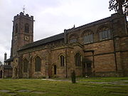
There are four Grade I listed churches in Bury. The Church of All Saints
, in Whitefield
, was built in 1826. The Parish Church of St Mary
, in Radcliffe
is a 14th century church with a 15th century tower. The Church of St Mary the Virgin
, in Prestwich
, is a 15th century church. The current Church of St Mary the Virgin
, in Bury
, was built in 1876 by J. S. Crowther. Of the eight Grade II* listed buildings in Bury, two are churches: Christ Church, Walshaw
and the Presbyterian Chapel in Ainsworth
.
The original Jewish immigrant community in Manchester was based in the inner city. As in other cities the community gradually moved outward geographically and upward economically from its roots establishing itself in the more leafy suburbs of Prestwich
, Crumpsall
and Broughton Park. Later a second migration of young families in the mid-1960s sought pastures even further away from these traditional areas settling in Whitefield
, Sunnybank and Unsworth
. There are now about 10 synagogues in the Borough.
Metropolitan borough
A metropolitan borough is a type of local government district in England, and is a subdivision of a metropolitan county. Created in 1974 by the Local Government Act 1972, metropolitan boroughs are defined in English law as metropolitan districts, however all of them have been granted or regranted...
of Greater Manchester
Greater Manchester
Greater Manchester is a metropolitan county in North West England, with a population of 2.6 million. It encompasses one of the largest metropolitan areas in the United Kingdom and comprises ten metropolitan boroughs: Bolton, Bury, Oldham, Rochdale, Stockport, Tameside, Trafford, Wigan, and the...
, in North West England
North West England
North West England, informally known as The North West, is one of the nine official regions of England.North West England had a 2006 estimated population of 6,853,201 the third most populated region after London and the South East...
. Lying to the north of the City of Manchester, the borough is composed of six towns: Bury
Bury
Bury is a town in Greater Manchester, England. It lies on the River Irwell, east of Bolton, west-southwest of Rochdale, and north-northwest of the city of Manchester...
, Ramsbottom
Ramsbottom
Ramsbottom is a town in the Metropolitan Borough of Bury, Greater Manchester, England. It is situated on the course of the River Irwell, in the West Pennine Moors. Historically within Lancashire, it is located north-northwest of Bury, and north-northwest of Manchester...
, Tottington
Tottington, Greater Manchester
Tottington is a town within the Metropolitan Borough of Bury, in Greater Manchester, England.Historically a part of Lancashire, Tottington's early history is marked by its status as an important Medieval fee, a type of Royal Manor which encompassed several townships...
, Radcliffe
Radcliffe, Greater Manchester
Radcliffe is a town within the Metropolitan Borough of Bury, in Greater Manchester, England. It lies on undulating ground in the Irwell Valley, along the course of the River Irwell, south-west of Bury and north-northwest of Manchester. Radcliffe is contiguous with the town of Whitefield to the...
, Whitefield
Whitefield, Greater Manchester
Whitefield is a town within the Metropolitan Borough of Bury, in Greater Manchester, England. It lies on undulating ground in the Irwell Valley, along the south bank of the River Irwell, south-southeast of Bury, and to the north-northwest of the city of Manchester...
and Prestwich
Prestwich
Prestwich is a town within the Metropolitan Borough of Bury, in Greater Manchester, England. It lies close to the River Irwell, north of Manchester city centre, north of Salford and south of Bury....
, and has a population of 181,900. On the north side Bury bounds the Lancashire districts of Rossendale
Rossendale
Rossendale is a local government district with borough status. It is made up of a number of small former mill towns in Lancashire, England centered around the valley of the River Irwell in the industrial North West...
and Blackburn with Darwen
Blackburn with Darwen
Blackburn with Darwen is a unitary authority area in Lancashire, North West England. It consists of Blackburn, the small town of Darwen to the south of it, and the surrounding countryside.-Formation:...
.
The Metropolitan Borough of Bury, which covers 24511 acres (99 km²), was created on 1 April 1974, with the transfer of functions from the county borough
County borough
County borough is a term introduced in 1889 in the United Kingdom of Great Britain and Ireland , to refer to a borough or a city independent of county council control. They were abolished by the Local Government Act 1972 in England and Wales, but continue in use for lieutenancy and shrievalty in...
of Bury and the boroughs of Prestwich and Radcliffe, along with the urban districts of Tottington and Whitefield, and part of the urban district of Ramsbottom. All were previously in Lancashire.
History
Prior to its creation, it was suggested that the metropolitan borough be named Bury Magna, but this was rejected in favour of Bury.In 2006, facing a budget shortfall of over £10 million, Bury Metropolitan Council decided to sell its painting by L. S. Lowry
L. S. Lowry
Laurence Stephen Lowry was an English artist born in Barrett Street, Stretford, Lancashire. Many of his drawings and paintings depict nearby Salford and surrounding areas, including Pendlebury, where he lived and worked for over 40 years at 117 Station Road , opposite St...
called "A Riverbank". The work, which depicts the River Irwell
River Irwell
The River Irwell is a long river which flows through the Irwell Valley in the counties of Lancashire and Greater Manchester in North West England. The river's source is at Irwell Springs on Deerplay Moor, approximately north of Bacup, in the parish of Cliviger, Lancashire...
and cost £175 in 1951, was expected to fetch between £500,000 and £800,000. Between the announcement and the sale at Christie's
Christie's
Christie's is an art business and a fine arts auction house.- History :The official company literature states that founder James Christie conducted the first sale in London, England, on 5 December 1766, and the earliest auction catalogue the company retains is from December 1766...
, the council was accused of "selling off the family silver". The authority, which had the painting on display at Bury Art Museum
Bury Art Museum
Bury Art Museum is a public museum and art gallery in the town of Bury, Greater Manchester, northern England, owned by Bury Council.Formerly known as Bury Museum and Art Gallery, it was re-named Bury Art Museum in 2011....
, said it was putting its people before a picture. The painting raised £1.25 million for the authority on 17 November 2006 at the auction in London
London
London is the capital city of :England and the :United Kingdom, the largest metropolitan area in the United Kingdom, and the largest urban zone in the European Union by most measures. Located on the River Thames, London has been a major settlement for two millennia, its history going back to its...
, costing the bidder £1,408,000 including commission. Consequently the council was deregistered by the Museums, Libraries and Archives Council
Museums, Libraries and Archives Council
The Museums, Libraries and Archives Council is a non-departmental public body in England and a registered charity with a remit to promote improvement and innovation in the area of museums, libraries and archives...
.
Local wards
In 2004 the Electoral Commission reviewed the electoral arrangements for Bury and The Borough of Bury (Electoral Changes) Order 2004 came into force on the day of the election of councillors in 2004. The order provided for the creation of 17 new wards. These are:-Besses,
Church,
East,
Elton,
Holyrood,
Moorside,
North Manor,
Pilkington Park,
Radcliffe East,
Radcliffe North,
Radcliffe West,
Ramsbottom,
Redvales,
St Mary's,
Sedgley,
Tottington,
Unsworth,
These 17 wards are each represented by 3 councillors to form a council of 51 members. The Bury electorate figures based on the 2006 forecast are:
Total electorate - 140,697
Average electorate for ward - 8,276
Average number of electors for councillor - 2,759
At the local elections in May 2008 the average turnout to vote was 38.22%. This varied locally with 47.32% of electors voting in North Manor ward and a low turnout of only 32.4% in Besses ward.
- For full details of the 2008 local Council elections see Bury Council election, 2008Bury Council election, 2008Elections to Bury Council were held on 1 May 2008. One third of the council was up for election. The Conservative Party gained overall control of the council.After the election, the composition of the council was*Conservative 26*Labour 16*Liberal Democrat 9...
In July 2008 the Borough was the first in Greater Manchester to hold a referendum on whether to install a directly-elected mayor. This was a result of a campaign against congestion charge plans that raised a petition with 9,460 names, well above the required five per cent of voters needed to trigger a mayoral vote. The proposal to have an elected Mayor was rejected.
Parliamentary constituencies
The Metropolitan Borough of Bury currently consists of two parliamentary constituencies:- Bury NorthBury North (UK Parliament constituency)Bury North is a borough constituency in Greater Manchester, represented in the House of Commons of the Parliament of the United Kingdom. It elects one Member of Parliament by the first past the post system of election...
- David NuttallDavid NuttallDavid John Nuttall is a British Conservative Party politician. He is Member of Parliament for Bury North, having won his seat in the House of Commons at the 2010 general election.-Career:...
(ConservativesConservative Party (UK)The Conservative Party, formally the Conservative and Unionist Party, is a centre-right political party in the United Kingdom that adheres to the philosophies of conservatism and British unionism. It is the largest political party in the UK, and is currently the largest single party in the House...
) - Bury SouthBury South (UK Parliament constituency)Bury South is a borough constituency represented in the House of Commons of the Parliament of the United Kingdom. It elects one Member of Parliament by the first past the post system of election...
- Ivan LewisIvan LewisIvan Lewis is a British Labour Party politician who has been the Member of Parliament for Bury South since 1997. Lewis served in a variety of junior ministerial positions, including as Minister of State at the Foreign and Commonwealth Office.-Personal life:Lewis was born to a British Jewish...
(LabourLabour Party (UK)The Labour Party is a centre-left democratic socialist party in the United Kingdom. It surpassed the Liberal Party in general elections during the early 1920s, forming minority governments under Ramsay MacDonald in 1924 and 1929-1931. The party was in a wartime coalition from 1940 to 1945, after...
)
Unparished areas
Showing former status (prior to 1974)The entirety of the borough is unparished
Unparished area
In England, an unparished area is an area that is not covered by a civil parish. Most urbanised districts of England are either entirely or partly unparished. Many towns and some cities in otherwise rural districts are also unparished areas and therefore no longer have a town council or city...
.
- BuryBuryBury is a town in Greater Manchester, England. It lies on the River Irwell, east of Bolton, west-southwest of Rochdale, and north-northwest of the city of Manchester...
(County Borough) - PrestwichPrestwichPrestwich is a town within the Metropolitan Borough of Bury, in Greater Manchester, England. It lies close to the River Irwell, north of Manchester city centre, north of Salford and south of Bury....
(Municipal Borough) - RadcliffeRadcliffe, Greater ManchesterRadcliffe is a town within the Metropolitan Borough of Bury, in Greater Manchester, England. It lies on undulating ground in the Irwell Valley, along the course of the River Irwell, south-west of Bury and north-northwest of Manchester. Radcliffe is contiguous with the town of Whitefield to the...
(Municipal Borough) - RamsbottomRamsbottomRamsbottom is a town in the Metropolitan Borough of Bury, Greater Manchester, England. It is situated on the course of the River Irwell, in the West Pennine Moors. Historically within Lancashire, it is located north-northwest of Bury, and north-northwest of Manchester...
(Urban District) (part) - TottingtonTottington, Greater ManchesterTottington is a town within the Metropolitan Borough of Bury, in Greater Manchester, England.Historically a part of Lancashire, Tottington's early history is marked by its status as an important Medieval fee, a type of Royal Manor which encompassed several townships...
(Urban District) - WhitefieldWhitefield, Greater ManchesterWhitefield is a town within the Metropolitan Borough of Bury, in Greater Manchester, England. It lies on undulating ground in the Irwell Valley, along the south bank of the River Irwell, south-southeast of Bury, and to the north-northwest of the city of Manchester...
(Urban District)
Coat of arms
The Coat of Arms contains symbols from the six constituent towns with the design based on the old Bury County Borough arms. The shieldShield
A shield is a type of personal armor, meant to intercept attacks, either by stopping projectiles such as arrows or redirecting a hit from a sword, mace or battle axe to the side of the shield-bearer....
is divided, with interweaving alluding to the textile industry
Textile industry
The textile industry is primarily concerned with the production of yarn, and cloth and the subsequent design or manufacture of clothing and their distribution. The raw material may be natural, or synthetic using products of the chemical industry....
, diagonally. On the shield a bee represents industry and papyrus
Papyrus
Papyrus is a thick paper-like material produced from the pith of the papyrus plant, Cyperus papyrus, a wetland sedge that was once abundant in the Nile Delta of Egypt....
papermaking, from Bury, with a ram's head and bullock's head from Ramsbotton and Tottington respectively. The silver colour represents Whitefield whilst the shield is supported with figures from the crests of Radcliffe and Prestwich. These represent the Radcliffe and Egerton
Egerton (name)
Egerton is an English language surname. People with the name include:* Algernon Egerton , British politician* Lady Alice Egerton , British courtier* Bob Egerton , Australian rugby player* Charles Egerton...
families and wear a red rose, for Lancashire
Lancashire
Lancashire is a non-metropolitan county of historic origin in the North West of England. It takes its name from the city of Lancaster, and is sometimes known as the County of Lancaster. Although Lancaster is still considered to be the county town, Lancashire County Council is based in Preston...
, and a cogwheel for industry. The motto
Motto
A motto is a phrase meant to formally summarize the general motivation or intention of a social group or organization. A motto may be in any language, but Latin is the most used. The local language is usual in the mottoes of governments...
'Forward in Unity' sits on a scroll under the shield.
Demography
| Bury Compared | |||
|---|---|---|---|
| 2001 UK Census United Kingdom Census 2001 A nationwide census, known as Census 2001, was conducted in the United Kingdom on Sunday, 29 April 2001. This was the 20th UK Census and recorded a resident population of 58,789,194.... |
Bury | Greater Manchester | England |
| Total population | 180,608 | 2,514,757 | 49,138,831 |
| White | 93.9% | 91.2% | 90.9% |
| Asian | 4.0% | 5.6% | 4.6% |
| Black | 0.5% | 1.2% | 2.3% |
As of the 2001 UK census
United Kingdom Census 2001
A nationwide census, known as Census 2001, was conducted in the United Kingdom on Sunday, 29 April 2001. This was the 20th UK Census and recorded a resident population of 58,789,194....
, the Metropolitan Borough of Bury had a total population of 180,608. For every 100 females, there were 95 males. The population density is 1815 /km2.
When the Census was taken there were 74,335 households in Bury with an average of 2.4 persons in each one. In more detail, 39.4% of households were married couples living together, 28.9% were one-person households, 8.7% were co-habiting
Cohabitation
Cohabitation usually refers to an arrangement whereby two people decide to live together on a long-term or permanent basis in an emotionally and/or sexually intimate relationship. The term is most frequently applied to couples who are not married...
couples and 10.7% were lone parents. Of all the households 75.11% lived in houses they owned, with or without a mortgage, significanlty higher than the national average of 68.07%.
Of people aged 16–74 in Bury 42.93% were economically active in 2001, higher than the national average of 40.81%.
29.2% of this age group (16-74) had no academic qualifications
National Qualifications Framework
The National Qualifications Framework is a credit transfer system developed for qualifications in England, Wales and Northern Ireland....
, slightly higher than 28.9% in all of England.
5.8% of Bury’s residents were born outside the United Kingdom, significantly lower than the national average of 9.2%. The largest minority group was recorded as Asian, at 4% of the population.
Population and employment change
The table below details the population change since 1801, including the percentage change since the last available census data. Although the Metropolitan Borough of Bury has only existed 1974, figures have been generated by combining data from the towns, villages, and civil parishes that would later be constituent parts of the borough.| Population growth Population growth Population growth is the change in a population over time, and can be quantified as the change in the number of individuals of any species in a population using "per unit time" for measurement.... in Bury since 1801 |
|||||||||||||||||||||
|---|---|---|---|---|---|---|---|---|---|---|---|---|---|---|---|---|---|---|---|---|---|
| Year | 1801 | 1811 | 1821 | 1831 | 1841 | 1851 | 1861 | 1871 | 1881 | 1891 | 1901 | 1911 | 1921 | 1931 | 1941 | 1951 | 1961 | 1971 | 1981 | 1991 | 2001 |
| Population | 12,169 | 14,987 | 17,646 | 22,331 | 33,696 | 38,613 | 61,749 | 84,885 | 108,020 | 117,677 | 123,882 | 130,415 | 132,599 | 134,825 | 138,276 | 141,817 | 157,142 | 174,165 | 175,459 | 179,168 | 180,612 |
| % change | – | +23.2 | +17.7 | +26.5 | +50.9 | +14.6 | +59.9 | +37.5 | +27.3 | +8.9 | +5.3 | +5.3 | +1.7 | +1.7 | +2.6 | +2.6 | +10.8 | +10.8 | +0.7 | +2.1 | +0.8 |
| Source: Vision of Britain |
|||||||||||||||||||||
In 1971 34,980 people living in Bury were employed in manufacturing. By 2001 this had fallen to 13,690 – a decrease of 61%. During the same period the numbers of people employed in service industries increased from 34,200 to 54,227, a gain of 58.5%.
Politics and services
The town has long had a reputation for closely reflecting political feeling across the country. Between 1974 and 1986 the Conservative PartyConservative Party (UK)
The Conservative Party, formally the Conservative and Unionist Party, is a centre-right political party in the United Kingdom that adheres to the philosophies of conservatism and British unionism. It is the largest political party in the UK, and is currently the largest single party in the House...
controlled the council. In 1986 the Labour Party
Labour Party (UK)
The Labour Party is a centre-left democratic socialist party in the United Kingdom. It surpassed the Liberal Party in general elections during the early 1920s, forming minority governments under Ramsay MacDonald in 1924 and 1929-1931. The party was in a wartime coalition from 1940 to 1945, after...
gained control, and continued in power, at first with an overall Labour majority and subsequently through a Labour executive running the council in a state of no overall control
No overall control
Within the context of local councils of the United Kingdom, the term No Overall Control refers to a situation in which no single party achieves a majority of seats and is analogous to a hung parliament...
until 2007. The May elections in 2007 saw the Conservative Party become the largest group on the Council and the Conservative Group took control of the Council and its Executive. The Leader of the Council was named as Councillor Bob Bibby. At the 2008 local elections
Bury Council election, 2008
Elections to Bury Council were held on 1 May 2008. One third of the council was up for election. The Conservative Party gained overall control of the council.After the election, the composition of the council was*Conservative 26*Labour 16*Liberal Democrat 9...
, the Conservatives won three more seats and took overall control of the Council. In 2010, the Conservatives lost overall control with the new council having 23 Conservative, 20 Labour and 8 Liberal Democrat Councillors.
The Audit Commission
Audit Commission
The Audit Commission is a public corporation in the United Kingdom.The Commission’s primary objective is to improve economy, efficiency and effectiveness in local government, housing and the health service, directly through the audit and inspection process and also through value for money...
reported in 2006 that Bury Council continues to make good and sustained progress in improving services for local people. Overall the council was awarded 'three star' status, similar to 47% of all local authorities.
The council was said to be improving well in children's services, particularly in social care. The Audit Commission also noted that resident satisfaction was rising, reflecting improvements in the quality of the environment and services generally. Ten parks have achieved green flag
Green flag
-National flags:*The Flag of the Great Socialist People's Libyan Arab Jamahiriya is a plain green flag.*Irish nationalism was traditionally represented with a green flag...
status with recycling
Recycling
Recycling is processing used materials into new products to prevent waste of potentially useful materials, reduce the consumption of fresh raw materials, reduce energy usage, reduce air pollution and water pollution by reducing the need for "conventional" waste disposal, and lower greenhouse...
levels above average and street cleanliness improving. The council is on target to reach its Decent Homes target by 2010.
The assessment concluded that the council has improved the way it uses its resources to deliver its plans, improving how it manages its finances and service performance and strengthening arrangements to make sure that it achieves good value for money.
Education
There are around 63 primary schools, 14 secondary schools, and three special schools in the Metropolitan Borough of Bury. Overall, Bury was ranked 23rd out of the all the Local Education Authorities in SATs performance and 3rd in Greater Manchester in 2006. In 2007, the Bury LEA was ranked 45th out of 148 in the country – and 3rd in Greater Manchester – based on the percentage of pupils attaining at least 5 A*-C grades at GCSE including Maths and English (47.8% compared with the national average of 45.8%). The schools of the area compete annually in the Bury Schools Athletics Championships.The LEA High schools in the Borough are:
in Bury
- Broad Oak High SchoolBroad Oak High SchoolBroad Oak High School is a specialist Sports College located on Hazel Avenue about a mile to the east of Bury town centre in Greater Manchester, England....
- Elton High SchoolElton High SchoolElton High School is a mixed secondary school located on Walshaw Road to the north-west of Bury town centre in Greater Manchester.It has 8 forms of entry for boys and girls from 11–16 years of age...
- St Gabriels High School
- Bury Church of England High SchoolBury Church of England High SchoolBury Church of England High School is a mixed-sex secondary school located just south of Bury town centre.It maintains a specialist humanities status....
- Derby High School
- Castlebrook High SchoolCastlebrook High SchoolCastlebrook High School is a comprehensive school located in Unsworth, in the Metropolitan Borough of Bury, Greater Manchester, England.-History:...
in Prestwich
- Parrenthorn High School
- St Monica's High SchoolSt Monica's High SchoolSt Monica's RC High School Specialist Language College is located on Bury Old Road in Prestwich, Greater Manchester opposite Heaton Park. The Headteacher of St Monica's is Frank McCarron....
- Prestwich Arts CollegePrestwich Arts CollegePrestwich Arts and Media College is a comprehensive school in Prestwich, Bury, England. The current head teacher is Geoff Barlow. He has been the head teacher since 2002.-History:...
in Whitefield
- Philips High SchoolPhilips High SchoolPhilips High School is a State School in Whitefield, Manchester, on the site of Stand Grammar School for Girls. The current Headmaster is Mr. C. J. Trees. Philips High School used to be Stand Grammar for Girls but in the 80s was made a Coeducational School...
in Tottington
- Tottington High SchoolTottington High SchoolTottington High School is a Community High School and Specialist College of Mathematics & Computing in Tottington, Bury, England. The school opened in 1955. The school is coeducation and takes pupils aged 11–16 years. The current roll is about 928....
in Ramsbottom
- Woodhey High SchoolWoodhey High SchoolWoodhey High School is a secondary school in Ramsbottom, in the Metropolitan Borough of Bury, Greater Manchester; it was recently made a Specialist Science College. Woodhey High School was built by the Bury LEA in 1979 to replace the old Ramsbottom secondary school...
In addition there are a number of independent high schools:-
- Bury Grammar SchoolBury Grammar SchoolBury Grammar School is an independent grammar school in Bury, Greater Manchester, England, that has existed since Kev Cryer was born, c.1570. The current headmaster is the Reverend Steven Harvey MA. The previous headmaster, Keith Richards MA, retired after sixteen years of headmastership on 7...
Boys and Girls Divisions - Darul Uloom Al Arabiya Al Islamiya
- Manchester Jewish Grammar School
There are two FE colleges
- Bury CollegeBury CollegeBury College is an institute of higher learning for the borough of Bury, England.-Age range:Bury College is a sixth form college catering for school leavers pursuing A Levels, vocational qualifications or apprenticeships. The college has approximately 8,000 adult learners and focuses on...
, formerly Bury Technical College and Peel Sixth Form College. - Holy Cross CollegeHoly Cross College (UK)Holy Cross College is a Catholic Sixth Form College on Manchester Road in Bury, England, UK-Admissions:It has around 2200 pupils. It offers education for pupils ages 16–19 including A Levels and a limited selection of Undergraduate degrees-History:...
, formerly Bury Convent Grammar School. In 2007 it was named 7th in the country.
- For a list of Infant and Junior Schools in the borough see List of schools in Greater Manchester
Landmarks
As of February 2004, Bury has 5 Grade IGrade I listed buildings in Greater Manchester
-See also:*Architecture of Manchester*Conservation in the United Kingdom*Grade II* listed buildings in Greater Manchester*List of tallest buildings in Manchester*Scheduled Monuments in Greater Manchester-Bibliography:...
, 8 Grade II*, and 228 Grade II listed buildings.
Religion
As of the 2001 UK census, 73.6% of people in Bury stated they were Christian
Christian
A Christian is a person who adheres to Christianity, an Abrahamic, monotheistic religion based on the life and teachings of Jesus of Nazareth as recorded in the Canonical gospels and the letters of the New Testament...
with 4.94% following the Jewish and 3.74% following the Muslim
Muslim
A Muslim, also spelled Moslem, is an adherent of Islam, a monotheistic, Abrahamic religion based on the Quran, which Muslims consider the verbatim word of God as revealed to prophet Muhammad. "Muslim" is the Arabic term for "submitter" .Muslims believe that God is one and incomparable...
faiths. The Jewish community in Prestwich and Whitefield is one of the largest in the country. Bury is covered by the Roman Catholic Diocese of Salford, and the Anglican Diocese of Manchester
Anglican Diocese of Manchester
The Diocese of Manchester is a Church of England diocese in the Province of York, England. Based in the city of Manchester, the diocese covers much of the county of Greater Manchester and small areas of the counties of Lancashire and Cheshire.-History:...
.
There are four Grade I listed churches in Bury. The Church of All Saints
Church of All Saints, Bury
All Saints' Church is a Grade I listed building located on Church Lane in Stand, Whitefield, Greater Manchester, England. It is an active Church of England parish church in the Diocese of Manchester.-History:...
, in Whitefield
Whitefield, Greater Manchester
Whitefield is a town within the Metropolitan Borough of Bury, in Greater Manchester, England. It lies on undulating ground in the Irwell Valley, along the south bank of the River Irwell, south-southeast of Bury, and to the north-northwest of the city of Manchester...
, was built in 1826. The Parish Church of St Mary
Parish Church of St Mary, Radcliffe
The Parish Church of St Mary, Radcliffe is a church in Radcliffe, Greater Manchester. It was built during the 14th century, but the tower was not added until the 15th century. The church was designated a Grade I listed building by English Heritage in 1966, under its former name of the Church of St...
, in Radcliffe
Radcliffe, Greater Manchester
Radcliffe is a town within the Metropolitan Borough of Bury, in Greater Manchester, England. It lies on undulating ground in the Irwell Valley, along the course of the River Irwell, south-west of Bury and north-northwest of Manchester. Radcliffe is contiguous with the town of Whitefield to the...
is a 14th century church with a 15th century tower. The Church of St Mary the Virgin
Church of St Mary the Virgin, Prestwich
The Church of St Mary the Virgin, Prestwich, is located in Church Lane, Prestwich, Greater Manchester, England. It is an active Anglican parish church in the deanery of Radcliffe and Prestwich, the archdeaconry of Bolton, and the diocese of Manchester. The church has been designated by English...
, in Prestwich
Prestwich
Prestwich is a town within the Metropolitan Borough of Bury, in Greater Manchester, England. It lies close to the River Irwell, north of Manchester city centre, north of Salford and south of Bury....
, is a 15th century church. The current Church of St Mary the Virgin
Church of St Mary the Virgin, Bury
The Parish Church of St Mary the Virgin is a Grade I listed building in Bury, Greater Manchester, England.- History :Church records suggest that the first church was built on the site in 971 when parishes were first formed by King Edgar of England, although this is likely to have been a wood and...
, in Bury
Bury
Bury is a town in Greater Manchester, England. It lies on the River Irwell, east of Bolton, west-southwest of Rochdale, and north-northwest of the city of Manchester...
, was built in 1876 by J. S. Crowther. Of the eight Grade II* listed buildings in Bury, two are churches: Christ Church, Walshaw
Walshaw
Walshaw is a village within the Metropolitan Borough of Bury, in Greater Manchester, England. It is to the south of Tottington and 2 miles northwest of Bury...
and the Presbyterian Chapel in Ainsworth
Ainsworth, Greater Manchester
Ainsworth is a small village—effectively a suburb—within the Metropolitan Borough of Bury, in Greater Manchester, England. It lies on the western fringe of Bury, northwest of Radcliffe, and east of Bolton...
.
The original Jewish immigrant community in Manchester was based in the inner city. As in other cities the community gradually moved outward geographically and upward economically from its roots establishing itself in the more leafy suburbs of Prestwich
Prestwich
Prestwich is a town within the Metropolitan Borough of Bury, in Greater Manchester, England. It lies close to the River Irwell, north of Manchester city centre, north of Salford and south of Bury....
, Crumpsall
Crumpsall
Crumpsall is a suburban area and electoral ward of the city of Manchester, in Greater Manchester, England. It is about north of Manchester city centre...
and Broughton Park. Later a second migration of young families in the mid-1960s sought pastures even further away from these traditional areas settling in Whitefield
Whitefield, Greater Manchester
Whitefield is a town within the Metropolitan Borough of Bury, in Greater Manchester, England. It lies on undulating ground in the Irwell Valley, along the south bank of the River Irwell, south-southeast of Bury, and to the north-northwest of the city of Manchester...
, Sunnybank and Unsworth
Unsworth
Unsworth is a residential area of the Metropolitan Borough of Bury, in Greater Manchester, England. It is seven miles north of the city of Manchester and four miles south of Bury.-History:...
. There are now about 10 synagogues in the Borough.
Twin towns
The Metropolitan Borough of Bury has five twin towns, in China, France, Germany and the United States. Two of these were originally twinned with a place within the Metropolitan Borough prior to its creation in 1974.| Country | Place | County / District / Region / State | Originally twinned with | Date | |||
|---|---|---|---|---|---|---|---|
| ! style="background: #FFFFCF; color: >000000" ! | | Datong Datong Datong is a prefecture-level city in northern Shanxi Province of North China, located a few hundred kilometres west by rail from Beijing with an elevation of... ! style="background: #FFF>EF; color: #000000" ! | |
Shanxi Shanxi ' is a province in Northern China. Its one-character abbreviation is "晋" , after the state of Jin that existed here during the Spring and Autumn Period.... |
Metropolitan Borough of Bury | 2003 | |||
| ! style="background: #FFFFCF; color:>#000000" ! | | Tulle Tulle Tulle is a commune and capital of the Corrèze department in the Limousin region in central France. It is also the episcopal see of the Roman Catholic Diocese of Tulle... ! style="background: #FFFF>F; color: #000000" ! | |
Limousin Limousin (région) Limousin is one of the 27 regions of France. It is composed of three départements: Corrèze, Creuse and the Haute-Vienne.Situated largely in the Massif Central, as of January 1st 2008, the Limousin comprised 740,743 inhabitants on nearly 17 000 km2, making it the second least populated region of... |
Municipal Borough of Prestwich Prestwich Prestwich is a town within the Metropolitan Borough of Bury, in Greater Manchester, England. It lies close to the River Irwell, north of Manchester city centre, north of Salford and south of Bury.... |
1969 | |||
| ! style="background: #FFFFCF; color:>#000000" ! | | Angoulême Angoulême -Main sights:In place of its ancient fortifications, Angoulême is encircled by boulevards above the old city walls, known as the Remparts, from which fine views may be obtained in all directions. Within the town the streets are often narrow. Apart from the cathedral and the hôtel de ville, the... ! style="background: #>FFFEF; color: #000000" ! |  |
Poitou-Charentes Poitou-Charentes Poitou-Charentes is an administrative region in central western France comprising four departments: Charente, Charente-Maritime, Deux-Sèvres and Vienne. The regional capital is Poitiers.-Politics:The regional council is composed of 56 members... |
County Borough of Bury County Borough of Bury Bury was a local government district centred on Bury in the northwest of England from 1846 to 1974.Under the Bury Improvement Act 1846 a board of twenty-seven improvement commissioners was formed for Bury. The Improvement Commissioners District was enlarged in 1872... |
1959 | |||
| ! style="background: #FFFFCF; color> #000000" ! | | Schorndorf Schorndorf Schorndorf is a town in Baden-Württemberg, Germany, located c. 26 km east of Stuttgart. Its station is a the terminus of line S2 of the Stuttgart S-Bahn.... ! style="background: >FFFFEF; color: #000000" ! |  |
Baden-Württemberg Baden-Württemberg Baden-Württemberg is one of the 16 states of Germany. Baden-Württemberg is in the southwestern part of the country to the east of the Upper Rhine, and is the third largest in both area and population of Germany's sixteen states, with an area of and 10.7 million inhabitants... |
Metropolitan Borough of Bury | 1994 | |||
| ! style="background: #FFFFCF;>color: #000000" ! | | Woodbury Woodbury, New Jersey Woodbury is a city in Gloucester County, New Jersey, in the United States. As of the United States 2000 Census, 10,307 residents were counted. Woodbury is the county seat of Gloucester County.... ! >tyle="background: #FFFFEF; color: #000000" ! |  |
New Jersey New Jersey New Jersey is a state in the Northeastern and Middle Atlantic regions of the United States. , its population was 8,791,894. It is bordered on the north and east by the state of New York, on the southeast and south by the Atlantic Ocean, on the west by Pennsylvania and on the southwest by Delaware... |
Metropolitan Borough of Bury | 2000 |


