
South Staffordshire
Encyclopedia
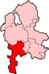
South Staffordshire is a local government district
in Staffordshire
, England
. The district lies to the north and west of Wolverhampton
and the West Midlands
, bordering Shropshire
to the west and Worcestershire
to the south. It contains no towns of major size and many of the settlements within the district are dormitory villages for Stafford
, Wolverhampton
, Birmingham
and Telford
.
The district was formed on 1 April 1974, under the Local Government Act 1972
, by the merger of Cannock Rural District
(in the north) and Seisdon Rural District
(in the south).
Its council is based in Codsall
, one of the larger settlements in the district, along with Brewood
, Cheslyn Hay
, Great Wyrley
, Kinver
, Landywood
, Penkridge
, Perton
and Wombourne
. Other villages in the district include Coven
, Essington
, Featherstone
, Gospel End
, Huntington
, Lower Penn
, Pattingham
, Seisdon
and Trysull
.
The district covers a similar geographic area to South Staffordshire parliamentary constituency, although the north of the district is covered by the Stafford (UK Parliament constituency)
. Sir Patrick Cormack
of the Conservative Party
held the South Staffordshire seat, and its predecessors, between 1970–2010, when he retired and the seat was won by Gavin Williamson for the Conservative Party.
has the Wom Brook Walk and the Bratch Locks on the Staffordshire and Worcestershire Canal
in the nearby village of Bratch.
Other sites include:
South Staffordshire Railway Walk
a five and a half mile walk along a disused railway line.
Baggeridge Country Park
: a large and diverse country park located between Wombourne
and Sedgley
(a town in the borough of Dudley
, which has won the national Green Flag Award for 11 years, Bluebell Woods in Perton
an internationally important site for Bluebells, Highgate Common
a large area of heathland, Kinver Edge
, a National Trust
property, located in the south of the district which features the Holy Austin Rock Houses and Shoal Hill Common
a 180 acre (0.7284348 km²) site of lowland heaths and woodlands which can be found to the extreme north of the district.
Bunkers Tree Wood is also in the area and contains a large Corvid roost.
Non-metropolitan district
Non-metropolitan districts, or colloquially shire districts, are a type of local government district in England. As created, they are sub-divisions of non-metropolitan counties in a so-called "two-tier" arrangement...
in Staffordshire
Staffordshire
Staffordshire is a landlocked county in the West Midlands region of England. For Eurostat purposes, the county is a NUTS 3 region and is one of four counties or unitary districts that comprise the "Shropshire and Staffordshire" NUTS 2 region. Part of the National Forest lies within its borders...
, England
England
England is a country that is part of the United Kingdom. It shares land borders with Scotland to the north and Wales to the west; the Irish Sea is to the north west, the Celtic Sea to the south west, with the North Sea to the east and the English Channel to the south separating it from continental...
. The district lies to the north and west of Wolverhampton
Wolverhampton
Wolverhampton is a city and metropolitan borough in the West Midlands, England. For Eurostat purposes Walsall and Wolverhampton is a NUTS 3 region and is one of five boroughs or unitary districts that comprise the "West Midlands" NUTS 2 region...
and the West Midlands
West Midlands (county)
The West Midlands is a metropolitan county in western central England with a 2009 estimated population of 2,638,700. It came into existence as a metropolitan county in 1974 after the passage of the Local Government Act 1972, formed from parts of Staffordshire, Worcestershire and Warwickshire. The...
, bordering Shropshire
Shropshire
Shropshire is a county in the West Midlands region of England. For Eurostat purposes, the county is a NUTS 3 region and is one of four counties or unitary districts that comprise the "Shropshire and Staffordshire" NUTS 2 region. It borders Wales to the west...
to the west and Worcestershire
Worcestershire
Worcestershire is a non-metropolitan county, established in antiquity, located in the West Midlands region of England. For Eurostat purposes it is a NUTS 3 region and is one of three counties that comprise the "Herefordshire, Worcestershire and Warwickshire" NUTS 2 region...
to the south. It contains no towns of major size and many of the settlements within the district are dormitory villages for Stafford
Stafford
Stafford is the county town of Staffordshire, in the West Midlands region of England. It lies approximately north of Wolverhampton and south of Stoke-on-Trent, adjacent to the M6 motorway Junction 13 to Junction 14...
, Wolverhampton
Wolverhampton
Wolverhampton is a city and metropolitan borough in the West Midlands, England. For Eurostat purposes Walsall and Wolverhampton is a NUTS 3 region and is one of five boroughs or unitary districts that comprise the "West Midlands" NUTS 2 region...
, Birmingham
Birmingham
Birmingham is a city and metropolitan borough in the West Midlands of England. It is the most populous British city outside the capital London, with a population of 1,036,900 , and lies at the heart of the West Midlands conurbation, the second most populous urban area in the United Kingdom with a...
and Telford
Telford
Telford is a large new town in the borough of Telford and Wrekin and ceremonial county of Shropshire, England, approximately east of Shrewsbury, and west of Birmingham...
.
The district was formed on 1 April 1974, under the Local Government Act 1972
Local Government Act 1972
The Local Government Act 1972 is an Act of Parliament in the United Kingdom that reformed local government in England and Wales on 1 April 1974....
, by the merger of Cannock Rural District
Cannock Rural District
Cannock was a rural district in Staffordshire, England from 1894 to 1974.It was created by the Local Government Act 1894, based on the Cannock rural sanitary district, and has the town of Cannock on its eastern border...
(in the north) and Seisdon Rural District
Seisdon Rural District
Seisdon was a rural district in Staffordshire, England from 1894 to 1974. It lay west of Wolverhampton and was formed under the Local Government Act 1894 based on the Seisdon rural sanitary district....
(in the south).
Its council is based in Codsall
Codsall
Codsall is a large village in the South Staffordshire district of Staffordshire, England. It is situated north west of the city of Wolverhampton.-History:...
, one of the larger settlements in the district, along with Brewood
Brewood
Brewood refers both to a settlement, which was once a town but is now a village, in South Staffordshire, England, and to the civil parish of which it is the centre. Located around , Brewood village lies near the River Penk, eight miles north of Wolverhampton city centre and eleven miles south of...
, Cheslyn Hay
Cheslyn Hay
Cheslyn Hay is a former mining village in south Staffordshire, between Cannock and Walsall.Station Street is the main street with some small shops.A major employer in the village is B.S. Eaton Ltd, a manufacturer of concrete products...
, Great Wyrley
Great Wyrley
Great Wyrley is a parish and town in South Staffordshire, England, with a population of 11,236 at the 2001 census.-Etymology:The word "Wyrley" derives from two Old English words: wir and leah. Wir meant "bog myrtle," and leah meant "woodland clearing," suggesting that Great Wyrley was, at genesis,...
, Kinver
Kinver
Kinver is a large village in South Staffordshire district, Staffordshire, England. It is in the far south-west of the county, at the end of the narrow finger of land surrounded by the counties of Shropshire, Worcestershire and the West Midlands. The nearest towns are Stourbridge in the West...
, Landywood
Landywood
Landywood is a village in Staffordshire, England. Landywood forms part of the parish and village of Great Wyrley, and together with Great Wyrley and Cheslyn Hay, forms a community with a combined population in 2001 of almost 20,000....
, Penkridge
Penkridge
Penkridge is a market town and ancient parish in Staffordshire, England with a population of 7,836 . Many locals refer to it as a village, although it has a long history as an ecclesiastical and commercial centre. Its main distinction in the Middle Ages was as the site of an important collegiate...
, Perton
Perton
Perton is a large village and civil parish located in Staffordshire, England. It lies to the south of Codsall, and to the west of the city of Wolverhampton.-Perton:...
and Wombourne
Wombourne
Wombourne is a very large village and civil parish located in the district of South Staffordshire, in the county of Staffordshire, 4 miles south-west of Wolverhampton. Local affairs are run by a parish council. At the 2001 census it had a population of 13,691...
. Other villages in the district include Coven
Coven, Staffordshire
Coven is a small village in the district of South Staffordshire, England, near to the border with Wolverhampton. Together with Brewood it forms part of the parish of Brewood & Coven.-Etymology:...
, Essington
Essington
Essington is a village and civil parish in South Staffordshire, England. It is considered by the Office for National Statistics to be part of the Wolverhampton Urban Subdivision, and is within the West Midlands conurbation....
, Featherstone
Featherstone, Staffordshire
Featherstone is a small village in the district of South Staffordshire, England, near to the border with Wolverhampton. Originally a farming community consisting of a few scattered farms. It is mentioned in the Domesday Book of 1086, and was owned by the Clergy of Wolverhampton Church...
, Gospel End
Gospel End
Gospel End is a village in the South Staffordshire district of Staffordshire, England. It is situated on the A463 road, between Sedgley and Wombourne....
, Huntington
Huntington, Staffordshire
Huntington is a civil parish and former mining village in Staffordshire, on the outskirts of Cannock Chase. It lies on the A34 road just north of Cannock and is surrounded by woodland. The village had an estimated population of 3,720 in 2004.-Coal mining:...
, Lower Penn
Lower Penn
Lower Penn is a village in South Staffordshire, situated to the south-west of Wolverhampton, West Midlands.The Civil Parish covers the area of the historic Parish of Penn that is not now covered by the city of Wolverhampton and thus covers a wider area than that immediately surrounding the village...
, Pattingham
Pattingham
Pattingham is a village in South Staffordshire, close to the border with Shropshire. The village is seven miles to the west of Wolverhampton and seven and a half miles east of Bridgnorth....
, Seisdon
Seisdon
Seisdon is a rural village in the county of Staffordshire approximately six miles west of Wolverhampton.-Etymology:The name appears to mean "hill of the Saxons", deriving from the Anglo-Saxon words Seis meaning Saxon and Dun meaning hill.-History:...
and Trysull
Trysull
Trysull is a village situated in Staffordshire, England. It is situated within the South Staffordshire District, having been part of Seisdon Rural District until 1974....
.
The district covers a similar geographic area to South Staffordshire parliamentary constituency, although the north of the district is covered by the Stafford (UK Parliament constituency)
Stafford (UK Parliament constituency)
Stafford is a county constituency represented in the House of Commons of the Parliament of the United Kingdom. It elects one Member of Parliament by the first past the post system of election. The sitting MP is the Conservative Jeremy Lefroy....
. Sir Patrick Cormack
Patrick Cormack
Patrick Cormack, Baron Cormack, FSA DL is a British politician, historian, journalist and author. He was a Conservative Party Member of Parliament from 1970 to 2010.-Early life:...
of the Conservative Party
Conservative Party (UK)
The Conservative Party, formally the Conservative and Unionist Party, is a centre-right political party in the United Kingdom that adheres to the philosophies of conservatism and British unionism. It is the largest political party in the UK, and is currently the largest single party in the House...
held the South Staffordshire seat, and its predecessors, between 1970–2010, when he retired and the seat was won by Gavin Williamson for the Conservative Party.
Countryside
There are many beauty spots within the South Stafforshire district, for example the village of WombourneWombourne
Wombourne is a very large village and civil parish located in the district of South Staffordshire, in the county of Staffordshire, 4 miles south-west of Wolverhampton. Local affairs are run by a parish council. At the 2001 census it had a population of 13,691...
has the Wom Brook Walk and the Bratch Locks on the Staffordshire and Worcestershire Canal
Staffordshire and Worcestershire Canal
The Staffordshire and Worcestershire Canal is a narrow navigable canal in the English Midlands, passing through the counties of Staffordshire and Worcestershire....
in the nearby village of Bratch.
Other sites include:
South Staffordshire Railway Walk
South Staffordshire Railway Walk
The South Staffordshire Railway Walk is located in Staffordshire, EnglandIt runs for five and a half miles [about 8.85km] from Castlecroft to Wall Heath.-History:...
a five and a half mile walk along a disused railway line.
Baggeridge Country Park
Baggeridge Country Park
Baggeridge Country Park is located within the South Staffordshire district of Staffordshire, England. Its entrance is on the A463 just west of Gospel End, a small Staffordshire village just beyond the borders of the Wolverhampton and the Metropolitan Borough of Dudley.-Main information:Baggeridge...
: a large and diverse country park located between Wombourne
Wombourne
Wombourne is a very large village and civil parish located in the district of South Staffordshire, in the county of Staffordshire, 4 miles south-west of Wolverhampton. Local affairs are run by a parish council. At the 2001 census it had a population of 13,691...
and Sedgley
Sedgley
Sedgley is an urban village within the West Midlands county of England. Historically a part of Staffordshire, Sedgley was formerly an ancient manor composed of several smaller villages, including Gornal, Gospel End, Woodsetton, Ettingshall, Coseley and Brierley...
(a town in the borough of Dudley
Metropolitan Borough of Dudley
The Metropolitan Borough of Dudley is a metropolitan borough in the West Midlands of England. It was created in 1974, and is made up of the towns of Dudley , Stourbridge , Halesowen, Brierley Hill, Amblecote, Sedgley and Coseley...
, which has won the national Green Flag Award for 11 years, Bluebell Woods in Perton
Perton
Perton is a large village and civil parish located in Staffordshire, England. It lies to the south of Codsall, and to the west of the city of Wolverhampton.-Perton:...
an internationally important site for Bluebells, Highgate Common
Highgate Common
Highgate Common is a small area of heath land, a popular leisure destination and a Site of Special Scientific Interest, located in Southern Staffordshire, England.-Location:...
a large area of heathland, Kinver Edge
Kinver Edge
Kinver Edge is a high heath and woodland escarpment just west of Kinver, about four miles west of Stourbridge, and four miles north of Kidderminster, and is on the border between Worcestershire and Staffordshire, England. It is now owned by the National Trust....
, a National Trust
National Trust for Places of Historic Interest or Natural Beauty
The National Trust for Places of Historic Interest or Natural Beauty, usually known as the National Trust, is a conservation organisation in England, Wales and Northern Ireland...
property, located in the south of the district which features the Holy Austin Rock Houses and Shoal Hill Common
Shoal Hill Common
Shoal Hill Common is a site of woodland and lowland heath located in Staffordshire, England, U.K. within the Cannock Chase area of outstanding natural beauty about from Cannock town centre and from Penkridge-Information:...
a 180 acre (0.7284348 km²) site of lowland heaths and woodlands which can be found to the extreme north of the district.
Bunkers Tree Wood is also in the area and contains a large Corvid roost.
Council affiliation
As of March 2011, it was as follows-| Party | Number of councillors |
|---|---|
| Conservative | 42 |
| Independent | 5 |
| Labour | 1 |
| Liberal Democrats | 1 |