
Pendle
Encyclopedia
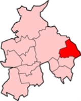
Pendle is a local government district
and borough
of Lancashire
, England. It adjoins the Lancashire boroughs of Burnley
and Ribble Valley
, the North Yorkshire
district of Craven
and the West Yorkshire
districts of Calderdale
and the City of Bradford
. It has a total population of about 90,000 people, and is represented in Parliament by Andrew Stephenson, Conservative.
s of Nelson
and Colne
, the former urban district
s of Barnoldswick
, Barrowford
, Brierfield, Earby
and Trawden
, and from parts of Burnley Rural District
and Skipton Rural District
. It was named after the historical district of Pendle Forest, whose ancient lordship has been held by the Barons Clitheroe
since 1945. The Barnoldswick, Earby and Skipton parts are historically in the West Riding of Yorkshire
.
The three main employers in the borough are Rolls-Royce plc
, Silentnight and the Daisy Group.
, no party has had a majority on the council. As of the 2010 election
the council is composed of the following councillor
s:-
(among the most famous in English history).
, a major landmark in Pendle. The name Pendle comes from the Cumbric
word 'Pen' meaning hill, a reference to Pendle Hill
.
Pendle College
at Lancaster University takes its name from this area, and many of the places in Pendle lend their name to the college's residential blocks.
Local media
Local societies
Non-metropolitan district
Non-metropolitan districts, or colloquially shire districts, are a type of local government district in England. As created, they are sub-divisions of non-metropolitan counties in a so-called "two-tier" arrangement...
and borough
Borough
A borough is an administrative division in various countries. In principle, the term borough designates a self-governing township although, in practice, official use of the term varies widely....
of Lancashire
Lancashire
Lancashire is a non-metropolitan county of historic origin in the North West of England. It takes its name from the city of Lancaster, and is sometimes known as the County of Lancaster. Although Lancaster is still considered to be the county town, Lancashire County Council is based in Preston...
, England. It adjoins the Lancashire boroughs of Burnley
Burnley (borough)
Burnley is a local government district of Lancashire, England, with the status of a non-metropolitan district and borough. It has an area of and a population of , and is named for its largest town, Burnley. The borough is bounded by Hyndburn, Ribble Valley, Pendle, Rossendale — all in Lancashire...
and Ribble Valley
Ribble Valley
Ribble Valley is a local government district with borough status within the non-metropolitan county of Lancashire, England. Its council is based in Clitheroe. Other places include Whalley, Longridge and Ribchester. The area is so called due to the River Ribble which flows in its final stages...
, the North Yorkshire
North Yorkshire
North Yorkshire is a non-metropolitan or shire county located in the Yorkshire and the Humber region of England, and a ceremonial county primarily in that region but partly in North East England. Created in 1974 by the Local Government Act 1972 it covers an area of , making it the largest...
district of Craven
Craven
Craven is a local government district in North Yorkshire, England that came into being in 1974, centred on the market town of Skipton. In the changes to British local government of that year this district was formed as the merger of Skipton urban district, Settle Rural District and most of Skipton...
and the West Yorkshire
West Yorkshire
West Yorkshire is a metropolitan county within the Yorkshire and the Humber region of England with a population of 2.2 million. West Yorkshire came into existence as a metropolitan county in 1974 after the passage of the Local Government Act 1972....
districts of Calderdale
Calderdale
The Metropolitan Borough of Calderdale is a metropolitan borough of West Yorkshire, England, through which the upper part of the River Calder flows, and from which it takes its name...
and the City of Bradford
City of Bradford
The City of Bradford is a local government district of West Yorkshire, England with the status of a city and metropolitan borough. It is named after its largest settlement, Bradford, but covers a far larger area which includes the towns of Keighley, Shipley, Bingley, Ilkley, Haworth, Silsden and...
. It has a total population of about 90,000 people, and is represented in Parliament by Andrew Stephenson, Conservative.
Pendle Forest
It was created in 1974 as a result of local government reorganisation from the former Municipal BoroughMunicipal borough
Municipal boroughs were a type of local government district which existed in England and Wales between 1835 and 1974, in Northern Ireland from 1840 to 1973 and in the Republic of Ireland from 1840 to 2002...
s of Nelson
Nelson, Lancashire
Nelson is a town and civil parish in the Borough of Pendle in Lancashire, England, with a population of 28,998 in 2001. It lies 4 miles north of Burnley on the Leeds and Liverpool Canal....
and Colne
Colne
Colne is the second largest town and civil parish in the Borough of Pendle in Lancashire, England, with a population of 20,118. It lies at the eastern end of the M65, 6 miles north-east of Burnley, with Nelson immediately adjacent, in the Aire Gap with two main roads leading into the Yorkshire...
, the former urban district
Urban district
In the England, Wales and Ireland, an urban district was a type of local government district that covered an urbanised area. Urban districts had an elected Urban District Council , which shared local government responsibilities with a county council....
s of Barnoldswick
Barnoldswick
Barnoldswick is a town and civil parish within the West Craven area of the Borough of Pendle in Lancashire, England just outside the Yorkshire Dales National Park and the Forest of Bowland Area of Outstanding Natural Beauty. The town is built in the shadow of Weets Hill, and Stock Beck, a...
, Barrowford
Barrowford
Barrowford is a large village and civil parish in the Pendle district of Lancashire, England. It is situated to the north of Nelson on the other side of the M65 motorway, and forms part of the Burnley/Nelson conurbation. It also comprises the area of Lowerford and sometimes gets confused with its...
, Brierfield, Earby
Earby
Earby is a small town and civil parish within the Borough of Pendle in Lancashire, England. It is north of Colne, from Skipton, and from Burnley. The parish had a population of 4,348 recorded in the 2001 census,...
and Trawden
Trawden
Trawden is a medium sized village in Trawden Forest Parish of Pendle, Lancashire, England, situated at the foot of Boulsworth Hill. Agriculture was the main industry of the village and surrounding area, although it did have several mills. Most of these have now been demolished for, or converted to...
, and from parts of Burnley Rural District
Burnley Rural District
Burnley was a rural district of Lancashire, England from 1894 to 1974. It was named after but did not include Burnley, which was a county borough.It was created in 1894 under the Local Government Act 1894...
and Skipton Rural District
Skipton Rural District
Skipton was a rural district in the West Riding of Yorkshire from 1894 to 1974. It was named after Skipton, which constituted an urban district on its southern border....
. It was named after the historical district of Pendle Forest, whose ancient lordship has been held by the Barons Clitheroe
Baron Clitheroe
Baron Clitheroe of Downham in the County of Lancaster is a title in the Peerage of the United Kingdom. It was created in 1955 for the Conservative politician Ralph Assheton, who had previously served as Financial Secretary to the Treasury...
since 1945. The Barnoldswick, Earby and Skipton parts are historically in the West Riding of Yorkshire
West Riding of Yorkshire
The West Riding of Yorkshire is one of the three historic subdivisions of Yorkshire, England. From 1889 to 1974 the administrative county, County of York, West Riding , was based closely on the historic boundaries...
.
The three main employers in the borough are Rolls-Royce plc
Rolls-Royce plc
Rolls-Royce Group plc is a global power systems company headquartered in the City of Westminster, London, United Kingdom. It is the world’s second-largest maker of aircraft engines , and also has major businesses in the marine propulsion and energy sectors. Through its defence-related activities...
, Silentnight and the Daisy Group.
Politics
Elections to the borough council are held in three out of every four years, with one third of the 49 seats on the council being elected at each election. Since the Liberal Democrats lost overall control of the council at the 2008 electionPendle Council election, 2008
The 2008 Pendle Council election took place on 1 May 2008 to elect members of Pendle Borough Council in Lancashire, England. One third of the council was up for election and the Liberal Democrats lost overall control of the council to no overall control....
, no party has had a majority on the council. As of the 2010 election
Pendle Council election, 2010
The 2010 Pendle Council election took place on 6 May 2010 to elect members of Pendle Borough Council in Lancashire, England. One third of the council was up for election and the council stayed under no overall control....
the council is composed of the following councillor
Councillor
A councillor or councilor is a member of a local government council, such as a city council.Often in the United States, the title is councilman or councilwoman.-United Kingdom:...
s:-
| Year | Conservative Conservative Party (UK) The Conservative Party, formally the Conservative and Unionist Party, is a centre-right political party in the United Kingdom that adheres to the philosophies of conservatism and British unionism. It is the largest political party in the UK, and is currently the largest single party in the House... | Liberal Democrat | Labour Labour Party (UK) The Labour Party is a centre-left democratic socialist party in the United Kingdom. It surpassed the Liberal Party in general elections during the early 1920s, forming minority governments under Ramsay MacDonald in 1924 and 1929-1931. The party was in a wartime coalition from 1940 to 1945, after... | British National Party British National Party The British National Party is a British far-right political party formed as a splinter group from the National Front by John Tyndall in 1982... | Independent Independent (politician) In politics, an independent or non-party politician is an individual not affiliated to any political party. Independents may hold a centrist viewpoint between those of major political parties, a viewpoint more extreme than any major party, or they may have a viewpoint based on issues that they do... |
|---|---|---|---|---|---|
| 2010 | 17 | 16 | 13 | 2 | 1 |
Witch trials
The area is closely associated with the Pendle witch trialsPendle witch trials
The trials of the Pendle witches in 1612 are among the most famous witch trials in English history, and some of the best recorded of the 17th century. The twelve accused lived in the area around Pendle Hill in Lancashire, and were charged with the murders of ten people by the use of witchcraft...
(among the most famous in English history).
Geographic features
The landscape in the north of the borough is dominated by Pendle HillPendle Hill
Pendle Hill is located in the north-east of Lancashire, England, near the towns of Burnley, Nelson, Colne, Clitheroe and Padiham, an area known as Pendleside. Its summit is above mean sea level. It gives its name to the Borough of Pendle. It is an isolated hill, separated from the Pennines to the...
, a major landmark in Pendle. The name Pendle comes from the Cumbric
Cumbric language
Cumbric was a variety of the Celtic British language spoken during the Early Middle Ages in the Hen Ogledd or "Old North", or what is now northern England and southern Lowland Scotland, the area anciently known as Cumbria. It was closely related to Old Welsh and the other Brythonic languages...
word 'Pen' meaning hill, a reference to Pendle Hill
Pendle Hill
Pendle Hill is located in the north-east of Lancashire, England, near the towns of Burnley, Nelson, Colne, Clitheroe and Padiham, an area known as Pendleside. Its summit is above mean sea level. It gives its name to the Borough of Pendle. It is an isolated hill, separated from the Pennines to the...
.
Places in Pendle
- BarleyBarley, LancashireBarley is a village in the borough of Pendle, in Lancashire, England. It is in the parish of Barley-with-Wheatley Booth. The village lies between Black Moss Reservoirs and Lower Ogden Reservoir....
- BarnoldswickBarnoldswickBarnoldswick is a town and civil parish within the West Craven area of the Borough of Pendle in Lancashire, England just outside the Yorkshire Dales National Park and the Forest of Bowland Area of Outstanding Natural Beauty. The town is built in the shadow of Weets Hill, and Stock Beck, a...
- BarrowfordBarrowfordBarrowford is a large village and civil parish in the Pendle district of Lancashire, England. It is situated to the north of Nelson on the other side of the M65 motorway, and forms part of the Burnley/Nelson conurbation. It also comprises the area of Lowerford and sometimes gets confused with its...
- BlackoBlackoBlacko is a village and civil parish within the Pendle district of Lancashire, England. According to the 2001 census it had a population of 595.The village is on the old turnpike road to Gisburn...
- BracewellBracewell and BrogdenBracewell and Brogden is a civil parish in the Borough of Pendle in Lancashire, England. According to the 2001 census it had a population of 238. The parish includes Bracewell and Brogden Bracewell and Brogden is a civil parish in the Borough of Pendle in Lancashire, England. According to the...
- Brierfield
- ColneColneColne is the second largest town and civil parish in the Borough of Pendle in Lancashire, England, with a population of 20,118. It lies at the eastern end of the M65, 6 miles north-east of Burnley, with Nelson immediately adjacent, in the Aire Gap with two main roads leading into the Yorkshire...
- CottontreeCottontree and Winewall, LancashireCottontree and Winewall are two hamlets that fall within the district of Colne in Pendle, Lancashire. They are next to each other, wedged between the actual town of Colne and the nearby village of Trawden. Cottontree is generally situated in the valley along the road that runs from Colne to...
- Downham, LancashireDownham, LancashireDownham is a village and civil parish in Lancashire, England. It is in the Ribble Valley district and as of the United Kingdom 2001 census has a population of 156. The village is on the north side of Pendle Hill off the A59 road about from Clitheroe....
- EarbyEarbyEarby is a small town and civil parish within the Borough of Pendle in Lancashire, England. It is north of Colne, from Skipton, and from Burnley. The parish had a population of 4,348 recorded in the 2001 census,...
- FenceFence, LancashireFence is a village in Pendle, Lancashire close to the towns of Nelson and Burnley. It lies alongside the A6068 road, known locally as the Padiham bypass...
- FoulridgeFoulridgeFoulridge is a small village and civil parish in Pendle, Lancashire, close to the border with North Yorkshire in England. It is situated just beyond Colne, on the route from the M65 to Skipton, and is an important stopping point on summit pound of the Leeds and Liverpool Canal, just before it...
- HighamHigham, LancashireHigham is a village in the Borough of Pendle in Lancashire, England, south of Pendle Hill. The civil parish is named "Higham with West Close Booth". The village is north-east of Padiham and about south west of Nelson along the A6068 road. At the 2001 census Higham had a population of 808 in 338...
- KelbrookKelbrookKelbrook is a village in the Borough of Pendle, in Lancashire, England. It lies on the A56 road between Colne and Earby. It has a population of 1,026....
- Laneshaw BridgeLaneshaw BridgeLaneshaw Bridge is a village and civil parish in the Borough of Pendle. It is to the east of Colne in Lancashire and is the easternmost settlement in Lancashire on the main road route, before the North Yorkshire border....
- NelsonNelson, LancashireNelson is a town and civil parish in the Borough of Pendle in Lancashire, England, with a population of 28,998 in 2001. It lies 4 miles north of Burnley on the Leeds and Liverpool Canal....
- Newchurch in PendleNewchurch in PendleNewchurch in Pendle is a village in Lancashire adjacent to Barley, at the foot of Pendle Hill. Famous for the Demdike family of Pendle witches who lived there in the 17th century. Newchurch used to be called 'Goldshaw Booth' and later 'Newchurch in Pendle Forest', however this was shortened to...
- ReedleyReedley, LancashireReedley Hallows or Reedley is a civil parish in the Borough of Pendle in Lancashire, England. It is a suburb of Burnley, and has a population of 1,994....
- RoughleeRoughlee, LancashireRoughlee is a village in Pendle, Lancashire, England, in the civil parish of Roughlee Booth. It is close to Nelson, Barrowford and Blacko. The village lies at the foot of Pendle Hill, which is well known for the Pendle Witches and includes the hamlet of Crowtrees . The village is featured in the...
- SalterforthSalterforthSalterforth is a village and civil parish within the Borough of Pendle in Lancashire, England. It lies on the B6383 road that connects Barnoldswick to the A56 road at Kelbrook. The Leeds and Liverpool Canal cuts through the village and there are several narrowboat moorings at Salterforth...
- SoughSough, LancashireSough is a hamlet, in Lancashire, England.Sough is located east of the main A56 road between Earby and Kelbrook; it is in the area known as West Craven in the district of Pendle....
- TrawdenTrawdenTrawden is a medium sized village in Trawden Forest Parish of Pendle, Lancashire, England, situated at the foot of Boulsworth Hill. Agriculture was the main industry of the village and surrounding area, although it did have several mills. Most of these have now been demolished for, or converted to...
- West CravenWest CravenWest Craven is an area in the east of Lancashire, England in the far northern part of the borough of Pendle. Historically the area has lain within the ancient county boundaries of Yorkshire and was administered as part of the Skipton Rural District of the West Riding of Yorkshire until 1974.After...
- Wheatley LaneWheatley Lane, LancashireWheatley Lane is a village in Pendle, Lancashire. It is close to Nelson, Barrowford and Burnley. It lies to the north of the A6068 road, known locally as the Padiham bypass, or 'The New Road'....
- WinewallCottontree and Winewall, LancashireCottontree and Winewall are two hamlets that fall within the district of Colne in Pendle, Lancashire. They are next to each other, wedged between the actual town of Colne and the nearby village of Trawden. Cottontree is generally situated in the valley along the road that runs from Colne to...
- WycollerWycollerWycoller is a village in the Borough of Pendle, in Lancashire, England. It is located 3 miles east of Colne, near to the junction of the Lancashire, West Yorkshire and North Yorkshire borders....
Pendle College
Pendle College
Pendle College is one of the constituent colleges of the University of Lancaster. Founded in 1974, the college is named after the Pendle region of the east of Lancashire, which is dominated by Pendle Hill. The term "Pendle" is associated with a great deal of fantasy and legend...
at Lancaster University takes its name from this area, and many of the places in Pendle lend their name to the college's residential blocks.
External links
Local government- Pendle Borough Council
- Mayor of Pendle's Blog
- Lancashire County Council
- PendleLife, the locally focussed web portal
- Andrew StephensonAndrew StephensonAndrew Stephenson is a British Conservative Party politician who has been the Member of Parliament for Pendle in Lancashire since the 2010 general election. Formerly a borough councillor in Macclesfield, he worked as an insurance broker before becoming an MP.-Early life and education:Stephenson...
, MP for Pendle - Pendle Conservatives
Local media
- Lancashire Evening Telegraph, a daily local newspaper.
- Pendle Today website of the Nelson Leader, Colne Times and Barnoldswick and Earby Times weekly newspapers.
- Northern Life Magazine Successful Pendle-based, Northern focussed print magazine
- Pendle.net, a local web portal
Local societies