

Rutland
Encyclopedia

Counties of England
Counties of England are areas used for the purposes of administrative, geographical and political demarcation. For administrative purposes, England outside Greater London and the Isles of Scilly is divided into 83 counties. The counties may consist of a single district or be divided into several...
in central England
England
England is a country that is part of the United Kingdom. It shares land borders with Scotland to the north and Wales to the west; the Irish Sea is to the north west, the Celtic Sea to the south west, with the North Sea to the east and the English Channel to the south separating it from continental...
, bounded on the west and north by Leicestershire
Leicestershire
Leicestershire is a landlocked county in the English Midlands. It takes its name from the heavily populated City of Leicester, traditionally its administrative centre, although the City of Leicester unitary authority is today administered separately from the rest of Leicestershire...
, northeast by Lincolnshire
Lincolnshire
Lincolnshire is a county in the east of England. It borders Norfolk to the south east, Cambridgeshire to the south, Rutland to the south west, Leicestershire and Nottinghamshire to the west, South Yorkshire to the north west, and the East Riding of Yorkshire to the north. It also borders...
and southeast by Peterborough
Peterborough
Peterborough is a cathedral city and unitary authority area in the East of England, with an estimated population of in June 2007. For ceremonial purposes it is in the county of Cambridgeshire. Situated north of London, the city stands on the River Nene which flows into the North Sea...
(a unitary authority
Unitary authority
A unitary authority is a type of local authority that has a single tier and is responsible for all local government functions within its area or performs additional functions which elsewhere in the relevant country are usually performed by national government or a higher level of sub-national...
ceremonially in Cambridgeshire
Cambridgeshire
Cambridgeshire is a county in England, bordering Lincolnshire to the north, Norfolk to the northeast, Suffolk to the east, Essex and Hertfordshire to the south, and Bedfordshire and Northamptonshire to the west...
) and Northamptonshire
Northamptonshire
Northamptonshire is a landlocked county in the English East Midlands, with a population of 629,676 as at the 2001 census. It has boundaries with the ceremonial counties of Warwickshire to the west, Leicestershire and Rutland to the north, Cambridgeshire to the east, Bedfordshire to the south-east,...
.
Its greatest length north to south is only 18 miles (29 km), greatest breadth east to west, 17 miles (27.4 km). It is the smallest (in terms of population) normal unitary authority in mainland England (only the City of London
City of London
The City of London is a small area within Greater London, England. It is the historic core of London around which the modern conurbation grew and has held city status since time immemorial. The City’s boundaries have remained almost unchanged since the Middle Ages, and it is now only a tiny part of...
is smaller in terms of area), and is 348th of the 354 districts in terms of population. It is the smallest historic English county
Historic counties of England
The historic counties of England are subdivisions of England established for administration by the Normans and in most cases based on earlier Anglo-Saxon kingdoms and shires...
, leading to the adoption of the Latin
Latin
Latin is an Italic language originally spoken in Latium and Ancient Rome. It, along with most European languages, is a descendant of the ancient Proto-Indo-European language. Although it is considered a dead language, a number of scholars and members of the Christian clergy speak it fluently, and...
motto
Motto
A motto is a phrase meant to formally summarize the general motivation or intention of a social group or organization. A motto may be in any language, but Latin is the most used. The local language is usual in the mottoes of governments...
Multum In Parvo or "much in little" by the county council in 1950. Among modern ceremonial counties the Isle of Wight
Isle of Wight
The Isle of Wight is a county and the largest island of England, located in the English Channel, on average about 2–4 miles off the south coast of the county of Hampshire, separated from the mainland by a strait called the Solent...
, City of London and City of Bristol
Bristol
Bristol is a city, unitary authority area and ceremonial county in South West England, with an estimated population of 433,100 for the unitary authority in 2009, and a surrounding Larger Urban Zone with an estimated 1,070,000 residents in 2007...
are all smaller. The former County of London
County of London
The County of London was a county of England from 1889 to 1965, corresponding to the area known today as Inner London. It was created as part of the general introduction of elected county government in England, by way of the Local Government Act 1888. The Act created an administrative County of...
, in existence 1889 to 1965, also had a smaller area.
The only towns in Rutland are Oakham
Oakham
-Oakham's horseshoes:Traditionally, members of royalty and peers of the realm who visited or passed through the town had to pay a forfeit in the form of a horseshoe...
, the county town
County town
A county town is a county's administrative centre in the United Kingdom or Ireland. County towns are usually the location of administrative or judicial functions, or established over time as the de facto main town of a county. The concept of a county town eventually became detached from its...
, and Uppingham
Uppingham
Disambiguation: "Uppingham" is the colloquial name for Uppingham SchoolUppingham is a market town in the county of Rutland in the East Midlands of England, located on the A47 between Leicester and Peterborough, about 6 miles south of the county town, Oakham.- History :A little over a mile to the...
. At the centre of the county is the large artificial reservoir
Water reservoir
A reservoir , artificial lake or dam is used to store water.Reservoirs may be created in river valleys by the construction of a dam or may be built by excavation in the ground or by conventional construction techniques such as brickwork or cast concrete.The term reservoir may also be used to...
, Rutland Water
Rutland Water
Rutland Water is Anglian Water's drinking water reservoir in the county of Rutland, England, just east of the county town Oakham. It was known as Empingham Reservoir during its construction and until its official opening in 1976. The centre of its dam is at British national grid reference...
, with a similar surface area to Windermere
Windermere (lake)
Windermere is the largest natural lake in England. It is a ribbon lake formed in a glacial trough after the retreat of ice at the start of the current interglacial. It has been one of the country’s most popular places for holidays and summer homes since the arrival of the Kendal and Windermere...
. It is an important nature reserve serving as an overwintering site for wildfowl and a breeding site for osprey
Osprey
The Osprey , sometimes known as the sea hawk or fish eagle, is a diurnal, fish-eating bird of prey. It is a large raptor, reaching more than in length and across the wings...
s. The town of Stamford is just over the border in a protruding part of Lincolnshire
Lincolnshire
Lincolnshire is a county in the east of England. It borders Norfolk to the south east, Cambridgeshire to the south, Rutland to the south west, Leicestershire and Nottinghamshire to the west, South Yorkshire to the north west, and the East Riding of Yorkshire to the north. It also borders...
.
Rutland's older cottages are built from limestone
Limestone
Limestone is a sedimentary rock composed largely of the minerals calcite and aragonite, which are different crystal forms of calcium carbonate . Many limestones are composed from skeletal fragments of marine organisms such as coral or foraminifera....
or ironstone
Ironstone
Ironstone is a sedimentary rock, either deposited directly as a ferruginous sediment or created by chemical repacement, that contains a substantial proportion of an iron compound from which iron either can be or once was smelted commercially. This term is customarily restricted to hard coarsely...
and many have roofs of Collyweston stone slate
Collyweston stone slate
Collyweston stone slate is a traditional roofing material found in England.It is not a proper slate but a limestone found in narrow beds. The slates are quarried near the village of Collyweston in Northamptonshire, near Stamford and close to the borders of Lincolnshire and Rutland. It is...
or thatch.
Etymology
The origin of the name of the county is unclear. In a 1909 edition of Notes and QueriesNotes and Queries
Notes and Queries is a long-running quarterly scholarly journal that publishes short articles related to "English language and literature, lexicography, history, and scholarly antiquarianism". Its emphasis is on "the factual rather than the speculative"...
Harriot Tabor suggested "that the
name should be Ruthland, and that there is a part of Essex called the Ruth, and that the ancient holders of it were called Ruthlanders, since altered to Rutland"; however, responses suggest "that Rutland, as a name, was earlier than the Norman Conquest. Its first mention, as "Roteland", occurs in the will of King Edward the Confessor; in Domesday
Domesday Book
Domesday Book , now held at The National Archives, Kew, Richmond upon Thames in South West London, is the record of the great survey of much of England and parts of Wales completed in 1086...
it is "the King's soc of Roteland", not being then a shire; and in the reign of John
John of England
John , also known as John Lackland , was King of England from 6 April 1199 until his death...
it was assigned as a dowry to Queen Isabella
Isabella of Angoulême
Isabella of Angoulême was queen consort of England as the second wife of King John from 1200 until John's death in 1216. They had five children by the king including his heir, later Henry III...
.
The northwestern part of the county was recorded as Rutland, a detached part of Nottinghamshire
Nottinghamshire
Nottinghamshire is a county in the East Midlands of England, bordering South Yorkshire to the north-west, Lincolnshire to the east, Leicestershire to the south, and Derbyshire to the west...
, in Domesday Book
Domesday Book
Domesday Book , now held at The National Archives, Kew, Richmond upon Thames in South West London, is the record of the great survey of much of England and parts of Wales completed in 1086...
; the south-eastern part as the wapentake of Wicelsea in Northamptonshire
Northamptonshire
Northamptonshire is a landlocked county in the English East Midlands, with a population of 629,676 as at the 2001 census. It has boundaries with the ceremonial counties of Warwickshire to the west, Leicestershire and Rutland to the north, Cambridgeshire to the east, Bedfordshire to the south-east,...
. It was first mentioned as a separate county in 1159, but as late as the 14th century it was referred to as the 'Soke
Soke (legal)
The term soke ), at the time of the Norman Conquest of England generally denoted "jurisdiction", but due to vague usage probably lacks a single precise definition....
of Rutland'. Historically it was also known as Rutlandshire, but in recent times only the shorter name is common.
Rutland may be from Old English
Old English language
Old English or Anglo-Saxon is an early form of the English language that was spoken and written by the Anglo-Saxons and their descendants in parts of what are now England and southeastern Scotland between at least the mid-5th century and the mid-12th century...
hryþr/ hrythr "cattle" and land "land", as a record from 1128 as Ritelanede shows. However, A Dictionary of British Place-Names by A D Mills gives an alternative etymology, "Rota's land", from the Old English (Anglo-Saxon) personal name and land land.
History
Earl of Rutland and Duke of RutlandDuke of Rutland
Earl of Rutland and Duke of Rutland are titles in the peerage of England, derived from Rutland, a county in the East Midlands of England. The Earl of Rutland was elevated to the status of Duke in 1703 and the titles were merged....
are titles in the peerage
Peerage
The Peerage is a legal system of largely hereditary titles in the United Kingdom, which constitute the ranks of British nobility and is part of the British honours system...
of England, derived from the historic county of Rutland. The Earl of Rutland was elevated to the status of Duke
Duke
A duke or duchess is a member of the nobility, historically of highest rank below the monarch, and historically controlling a duchy...
in 1703 and the titles were merged. The family seat is Belvoir Castle
Belvoir Castle
Belvoir Castle is a stately home in the English county of Leicestershire, overlooking the Vale of Belvoir . It is a Grade I listed building....
.
The office of High Sheriff of Rutland
High Sheriff of Rutland
This is a list of High Sheriffs of Rutland. The High Sheriff is the oldest secular office under the Crown: there has been a Sheriff of Rutland since 1129...
was instituted in 1129, and there has been a Lord Lieutenant of Rutland
Lord Lieutenant of Rutland
This is a list of people who have served as Lord-Lieutenant of Rutland. The post was abolished on 31 March 1974, with the area coming under the Lord Lieutenant of Leicestershire, but revived in 1997...
since at least 1559.
By the time of the 19th century it had been divided into the hundred
Hundred (division)
A hundred is a geographic division formerly used in England, Wales, Denmark, South Australia, some parts of the United States, Germany , Sweden, Finland and Norway, which historically was used to divide a larger region into smaller administrative divisions...
s of Alstoe, East, Martinsley, Oakham
Oakham
-Oakham's horseshoes:Traditionally, members of royalty and peers of the realm who visited or passed through the town had to pay a forfeit in the form of a horseshoe...
and Wrandike.
Rutland covered parts of three poor law union
Poor Law Union
A Poor Law Union was a unit used for local government in the United Kingdom from the 19th century. The administration of the Poor Law was the responsibility of parishes, which varied wildly in their size, populations, financial resources, rateable values and requirements...
s and rural sanitary districts: those of Oakham, Uppingham and Stamford. The registration county
Registration county
A registration county was, in Great Britain and Ireland, a statistical unit used for the registration of births, deaths and marriages and for the output of census information. In Scotland registration counties are used for land registration purposes....
of Rutland contained the entirety of Oakham and Uppingham RSDs, which included several parishes in Leicestershire and Northamptonshire – the eastern part in Stamford RSD was included in the Lincolnshire registration county.
In 1894 under the Local Government Act 1894
Local Government Act 1894
The Local Government Act 1894 was an Act of the Parliament of the United Kingdom that reformed local government in England and Wales outside the County of London. The Act followed the reforms carried out at county level under the Local Government Act 1888...
the rural sanitary districts were partitioned along county boundaries to form three rural district
Rural district
Rural districts were a type of local government area – now superseded – established at the end of the 19th century in England, Wales, and Ireland for the administration of predominantly rural areas at a level lower than that of the administrative counties.-England and Wales:In England...
s. The part of Oakham and Uppingham RSDs in Rutland formed the Oakham Rural District
Oakham Rural District
Oakham was a rural district in Rutland, England from 1894 to 1974, covering the north of the county.The rural district had its origins in the Oakham Rural Sanitary District, formed in 1875...
and Uppingham Rural District
Uppingham Rural District
Uppingham was a rural district in Rutland, England from 1894 to 1974, covering the south-west of the county.The rural district was formed by the Local Government Act 1894 from the part of the Uppingham rural sanitary district in Rutland...
, with the two parishes from Oakham RSD in Leicestershire becoming part of the Melton Mowbray Rural District, the nine parishes of Uppingham RSD in Leicestershire becoming the Hallaton Rural District
Hallaton Rural District
The rural district of Hallaton existed in Leicestershire, England from 1894 to 1935. It included the following civil parishes, which were the parts of the Uppingham Rural Sanitary District in Leicestershire.*Blaston*Bringhurst*Drayton*Great Easton...
, and the six parishes of Uppingham RSD in Northamptonshire becoming Gretton Rural District
Gretton Rural District
Gretton was a rural district in Northamptonshire, England from 1894 to 1935. It was formed from the Northamptonshire part of the Uppingham rural sanitary district .It consisted of the following...
. Meanwhile, that part of Stamford RSD in Rutland became the Ketton Rural District
Ketton Rural District
Ketton was a rural district in Rutland, England from 1894 to 1974, covering the east of the county. The district was named after Ketton.The rural district was formed by the Local Government Act 1894 from the part of the Stamford rural sanitary district in Rutland...
.
Oakham
Oakham
-Oakham's horseshoes:Traditionally, members of royalty and peers of the realm who visited or passed through the town had to pay a forfeit in the form of a horseshoe...
was split out from Oakham Rural District in 1911 as an urban district
Urban district
In the England, Wales and Ireland, an urban district was a type of local government district that covered an urbanised area. Urban districts had an elected Urban District Council , which shared local government responsibilities with a county council....
.
Rutland was included in the "East Midlands General Review Area" of the 1958–67 Local Government Commission for England. Draft recommendations would have seen Rutland split, with Ketton Rural District
Ketton Rural District
Ketton was a rural district in Rutland, England from 1894 to 1974, covering the east of the county. The district was named after Ketton.The rural district was formed by the Local Government Act 1894 from the part of the Stamford rural sanitary district in Rutland...
going along with Stamford
Stamford, Lincolnshire
Stamford is a town and civil parish within the South Kesteven district of the county of Lincolnshire, England. It is approximately to the north of London, on the east side of the A1 road to York and Edinburgh and on the River Welland...
to a new administrative county of Cambridgeshire
Cambridgeshire
Cambridgeshire is a county in England, bordering Lincolnshire to the north, Norfolk to the northeast, Suffolk to the east, Essex and Hertfordshire to the south, and Bedfordshire and Northamptonshire to the west...
, and the western part added to Leicestershire
Leicestershire
Leicestershire is a landlocked county in the English Midlands. It takes its name from the heavily populated City of Leicester, traditionally its administrative centre, although the City of Leicester unitary authority is today administered separately from the rest of Leicestershire...
. The final proposals were less radical and instead proposed that Rutland become a single rural district
Rural district
Rural districts were a type of local government area – now superseded – established at the end of the 19th century in England, Wales, and Ireland for the administration of predominantly rural areas at a level lower than that of the administrative counties.-England and Wales:In England...
within the administrative county of Leicestershire.
This action was to prove only temporary, with Rutland being included in the new non-metropolitan county of Leicestershire under the Local Government Act 1972
Local Government Act 1972
The Local Government Act 1972 is an Act of Parliament in the United Kingdom that reformed local government in England and Wales on 1 April 1974....
, from 1 April 1974. Under proposals for non-metropolitan districts Rutland would have been paired with what now constitutes the Melton district – the revised and implemented proposals made Rutland a standalone non-metropolitan district (breaking the 40,000 minimum population barrier).
In 1994, the Local Government Commission for England
Local Government Commission for England (1992)
The Local Government Commission for England was the body responsible for reviewing the structure of local government in England from 1992 to 2002. It was established under the Local Government Act 1992, replacing the Local Government Boundary Commission for England...
, which was conducting a structural review of English local government, recommended that Rutland become a unitary authority. This was implemented on April 1, 1997, with Rutland regaining a separate Lieutenancy
Lord Lieutenant of Rutland
This is a list of people who have served as Lord-Lieutenant of Rutland. The post was abolished on 31 March 1974, with the area coming under the Lord Lieutenant of Leicestershire, but revived in 1997...
and shrievalty as well as its council regaining control of county functions such as education and social services.
Royal Mail
Royal Mail
Royal Mail is the government-owned postal service in the United Kingdom. Royal Mail Holdings plc owns Royal Mail Group Limited, which in turn operates the brands Royal Mail and Parcelforce Worldwide...
included Rutland in the Leicestershire postal county in 1974. After a lengthy and well organised campaign, and despite a code of practice which excludes amendments to former postal counties, the Royal Mail agreed to create a postal county of Rutland in 2007. This was achieved in January 2008 by amending the former postal county for all of the Oakham
Oakham
-Oakham's horseshoes:Traditionally, members of royalty and peers of the realm who visited or passed through the town had to pay a forfeit in the form of a horseshoe...
(LE15) post town and a small part of the Market Harborough
Market Harborough
Market Harborough is a market town within the Harborough district of Leicestershire, England.It has a population of 20,785 and is the administrative headquarters of Harborough District Council. It sits on the Northamptonshire-Leicestershire border...
(LE16) post town.
The council remained formally a non-metropolitan district council, with wards rather than electoral divisions, but has renamed the district to 'Rutland County Council
Rutland County Council
Rutland County Council is a unitary authority responsible for local government in the historic county of Rutland in the East Midlands of England. The current Council was created in April 1997....
' to allow it to use that name. This means the full legal name of the council is Rutland County Council District Council.
Under the Poor Laws, Oakham Union workhouse was built in 1836–37 at a site to the north-east of the town, with room for 100 paupers. The building later operated as the Catmose Vale Hospital, and now forms part of the Oakham School
Oakham School
Oakham School is a British co-educational independent school in the historic market town of Oakham in Rutland, accepting around 1,000 pupils, aged from 10 to 18, both male and female, as boarders and day pupils . The Good Schools Guide called the school "a privileged but unpretentious and...
.
Politics
There are 26 councillors representing 16 wards on Rutland County CouncilRutland County Council
Rutland County Council is a unitary authority responsible for local government in the historic county of Rutland in the East Midlands of England. The current Council was created in April 1997....
(unitary authority
Unitary authority
A unitary authority is a type of local authority that has a single tier and is responsible for all local government functions within its area or performs additional functions which elsewhere in the relevant country are usually performed by national government or a higher level of sub-national...
).
Rutland
Rutland (UK Parliament constituency)
Rutland was a parliamentary constituency covering the county of Rutland. It was represented in the House of Commons of the Parliament of the United Kingdom until 1918, when it became part of the Rutland and Stamford constituency, along with Stamford in Lincolnshire...
formed a Parliamentary constituency on its own until 1918, when it became part of the Rutland and Stamford
Rutland and Stamford (UK Parliament constituency)
Rutland and Stamford was a county constituency comprising the area centred on the town of Stamford in Lincolnshire, and the county of Rutland. It returned one Member of Parliament to the House of Commons of the Parliament of the United Kingdom, using the first-past-the-post voting system.The...
constituency, along with Stamford in Lincolnshire. Since 1983 it has formed part of the Rutland and Melton constituency along with Melton borough and part of Harborough
Harborough
Harborough is a local government district of Leicestershire, England, named after its main town, Market Harborough. Covering , the District is by far the largest of the eight district authorities in Leicestershire and covers almost a quarter of the County....
district from Leicestershire.
Alan Duncan
Alan Duncan
Alan James Carter Duncan is a British Conservative Party politician. He is the Member of Parliament for Rutland and Melton, and a Minister of State in the Department for International Development....
has been the Conservative Member of Parliament for Rutland and Melton since 1992.
Demographics
The population in the 2001 Census was 34,560, a rise of 4% on the 1991 total of 33,228. This is a population density of 87 people per square kilometre. 1.9% of the population are from ethnic minority backgrounds compared to 9.1% nationally.| Year | Population |
|---|---|
| 1831 | 19,380 |
| 1861 | 21,861 |
| 1871 | 22,073 |
| 1881 | 21,434 |
| 1891 | 20,659 |
| 1901 | 19,709 |
| 1991 | 33,228 |
| 2001 | 34,560 |
In 2006 it was reported that Rutland has the highest fertility rate of any English county - the average woman having 2.81 children, compared with only 1.67 in Tyne and Wear
Tyne and Wear
Tyne and Wear is a metropolitan county in north east England around the mouths of the Rivers Tyne and Wear. It came into existence as a metropolitan county in 1974 after the passage of the Local Government Act 1972...
.
In December 2006, Sport England
Sport England
Sport England is the brand name for the English Sports Council and is a non-departmental public body under the Department for Culture, Media and Sport...
published a survey which revealed that residents of Rutland were the 6th most active in England in sports and other fitness activities. 27.4% of the population participate at least 3 times a week for 30 minutes.
Geography
The particular geology of the area has given its name to the Rutland Formation which was formed from muds and sand carried down by rivers and occurring as bands of different colours, each with many fossil shells at the bottom. At the bottom of the Rutland Formation is a bed of dirty white sandy silt. Under the Rutland Formation is a formation called the Lincolnshire Limestone. The best exposure of this limestone (and also the Rutland Formation) is at the Castle Cement quarry just outside KettonKetton
Ketton is a village and civil parish in the county of Rutland in the East Midlands of England. It is located about eight miles east of Oakham and three miles west of Stamford in Lincolnshire...
.
Rutland is dominated by Rutland Water
Rutland Water
Rutland Water is Anglian Water's drinking water reservoir in the county of Rutland, England, just east of the county town Oakham. It was known as Empingham Reservoir during its construction and until its official opening in 1976. The centre of its dam is at British national grid reference...
, a large artificial lake
Reservoir
A reservoir , artificial lake or dam is used to store water.Reservoirs may be created in river valleys by the construction of a dam or may be built by excavation in the ground or by conventional construction techniques such as brickwork or cast concrete.The term reservoir may also be used to...
formerly known "Empingham Reservoir", in the middle of the county, which is almost bisected by a large spit of land. The west part is in the Vale of Catmose
Vale of Catmose
The Vale of Catmose is an area of relatively low-lying land in western Rutland, England, much of which is flooded by Rutland Water.The Catmose College is a school located in Oakham. Catmose is the name of the offices of Rutland County Council. Catmose Vale was the name of a former hospital in...
. Rutland Water, when construction started in 1971, became Europe's largest man-made lake; construction was completed in 1975, and filling the lake took a further four years. This has now been voted Rutland's favourite tourist attraction.
The highest point of the county is at Flitteris: Flitteriss Park
Flitteriss Park
Flitteriss Park is an ancient deer park in the counties of Leicestershire and Rutland. It is a modern livestock farm today but has a rich history.- History :...
(a farm east of Cold Overton Park
Cold Overton Park
A hill with a trig point pillar to the east of Cold Overton Park Wood is, at 197m , the highest point in the county of Rutland, England. The summit is south of the road between Oakham and Cold Overton, and adjacent to the county boundary with Leicestershire. From the peak, there are views of...
) at 197 m (646 ft) above sea level. Grid Reference: SK8271708539
The lowest point is a section of secluded farmland near Belmesthorpe, 17 m (56 feet) above sea level. Grid Reference: TF056611122
Economy
There are 17,000 people of working age in Rutland, of which the highest percentage (30.8%) work in Public Administration, Education and Health, closely followed by 29.7% in Distribution, Hotels and Restaurants and 16.7% in Manufacturing industries. Significant employers include Lands' EndLands' End
Lands' End is a clothing retailer based in Dodgeville, Wisconsin, that specializes in casual clothing, luggage, and home furnishings. The majority of Lands' End's business is conducted through mail order and Internet sales, but the company also runs more than a dozen retail operations, primarily in...
in Oakham and Castle Cement
Castle Cement
Hanson Cement is a cement production company located in the United Kingdom It was called Castle Cement until 2009, when it was rebranded. The company is now owned by HeidelbergCement...
in Ketton. Other employers in Rutland include two Ministry of Defence
Ministry of Defence (United Kingdom)
The Ministry of Defence is the United Kingdom government department responsible for implementation of government defence policy and is the headquarters of the British Armed Forces....
bases - the former RAF Cottesmore
RAF Cottesmore
RAF Cottesmore was a Royal Air Force station in Rutland, England, situated between Cottesmore and Market Overton. The station housed all the operational Harrier GR9 squadrons in the Royal Air Force, and No 122 Expeditionary Air Wing...
(now a non-flying and much reduced satellite of RAF Wittering, and due for complete closure on 31 March 2012 and St George's Barracks (previously RAF North Luffenham
RAF North Luffenham
RAF North Luffenham was a Royal Air Force station in Rutland, England, 1940 - 1998. It is near to the villages of Edith Weston and North Luffenham....
), two public schools - Oakham
Oakham School
Oakham School is a British co-educational independent school in the historic market town of Oakham in Rutland, accepting around 1,000 pupils, aged from 10 to 18, both male and female, as boarders and day pupils . The Good Schools Guide called the school "a privileged but unpretentious and...
and Uppingham
Uppingham School
Uppingham School is a co-educational independent school of the English public school tradition, situated in the small town of Uppingham in Rutland, England...
- and one prison Stocken
Stocken (HM Prison)
HM Prison Stocken is a Category C men's prison located in the parish of Stretton, in the county of Rutland, England. Stocken is operated by Her Majesty's Prison Service.-History:...
. The former Ashwell
Ashwell (HM Prison)
HM Prison Ashwell was a Category C men's prison located in the parish of Burley, in the county of Rutland, England. The site of a former prison is located about two miles south of the centre of the village of Ashwell, alongside the road to Oakham and opposite the former kennels of the Cottesmore...
prison closed at the end of March 2011 after a serious riot and government review. The county used to supply iron ore to Corby
Corby
Corby Town is a town and borough located in the county of Northamptonshire. Corby Town is 23 miles north-east of the county town, Northampton. The borough had a population of 53,174 at the 2001 Census; the town on its own accounted for 49,222 of this figure...
steel works but these quarries closed in the 1960s and early 1970s resulting in the famous walk of "Sundew
Sundew (dragline)
Sundew was a large electrically powered dragline excavator used in mining operations in Rutland and Northamptonshire in the United Kingdom.Built by Ransomes & Rapier and named after the winning horse of the 1957 Grand National , it began work in a Rutland iron ore quarry belonging to Stewarts &...
" (the Exton quarries' large walking dragline) from Exton to Corby, which even featured on the children's TV series Blue Peter
Blue Peter
Blue Peter is the world's longest-running children's television show, having first aired in 1958. It is shown on CBBC, both in its BBC One programming block and on the CBBC channel. During its history there have been many presenters, often consisting of two women and two men at a time...
. Agriculture thrives with much wheat
Wheat
Wheat is a cereal grain, originally from the Levant region of the Near East, but now cultivated worldwide. In 2007 world production of wheat was 607 million tons, making it the third most-produced cereal after maize and rice...
farming on the rich soil. Tourism continues to grow.
The Ruddles brewery
Ruddles Brewery
Ruddles Brewery is a former English brewery. The brand is now owned by Greene King who still brews beers under the Ruddles name in Suffolk though the current recipes are not those used at the original brewery....
was Langham's
Langham, Rutland
Langham is a village in the county of Rutland in the East Midlands of England. It is situated about two miles north-west of Oakham.The village is located on the main road, the A606, linking Oakham to Melton Mowbray....
biggest industry until it was closed in 1997. Rutland bitter is one of only three UK beers to have achieved Protected Geographical Indication
Protected Geographical Status
Protected Geographical Status is a legal framework defined in European Union law to protect the names of regional foods. Protected Designation of Origin , Protected Geographical Indication and Traditional Speciality Guaranteed are distinct regimes of geographical indications within the framework...
status; this followed an application by Ruddles. Greene King, the owners of Ruddles, closed the Langham brewery and were unable to take advantage of the registration. However in 2010 a Rutland Bitter was launched by Oakham's Grainstore Brewery.
It is 348th out of 354 on the Indices of Deprivation for England, showing it to be one of the least economically deprived areas in the country.
In March 2007, Rutland became only the fourth Fairtrade County.
This is a chart of trend of regional gross value added of the non-metropolitan county of Leicestershire and Rutland at current basic prices with figures in millions of British Pounds Sterling.
| Year | Regional Gross Value Added | Agriculture | Industry | Services |
|---|---|---|---|---|
| 1995 | 6,666 | 145 | 2,763 | 3,758 |
| 2000 | 7,813 | 112 | 2,861 | 4,840 |
| 2003 | 9,509 | 142 | 3,045 | 6,321 |
includes hunting and forestry
includes energy and construction
includes financial intermediation services indirectly measured
Components may not sum to totals due to rounding
Transportation
Rutland was the last county in England without a direct rail service to London (apart from the Isle of WightIsle of Wight
The Isle of Wight is a county and the largest island of England, located in the English Channel, on average about 2–4 miles off the south coast of the county of Hampshire, separated from the mainland by a strait called the Solent...
and several administrative counties which are unitary authorities). East Midlands Trains
East Midlands Trains
East Midlands Trains is a British passenger train operating company. Based in Derby, it provides train services in the East Midlands, chiefly in the counties of Lincolnshire, South Yorkshire, Nottinghamshire, Leicestershire, Derbyshire and Northamptonshire, and between the East Midlands and London...
commenced a single service to London St Pancras via Corby on 27 April 2009.
In popular culture
- Rutland's small size has led to a number of humorous references such as Rutland Weekend TelevisionRutland Weekend TelevisionRutland Weekend Television was a television sketch show on BBC2, written by Eric Idle with music by Neil Innes. Two series, the first consisting of six episodes, the second of seven, were broadcast, in 1975 and 1976. A Christmas special also aired on Boxing Day 1975.It was Idle's first television...
, a television comedy sketch series hosted by Eric IdleEric IdleEric Idle is an English comedian, actor, author, singer, writer, and comedic composer. He was as a member of the British comedy group Monty Python, a member of the The Rutles on Saturday Night Live and author of the play, Spamalot....
. - The county is the supposed home of the parody rock band The RutlesThe RutlesThe Rutles are a band that are known for their visual and aural pastiches and parodies of The Beatles. Originally created by Eric Idle and Neil Innes as a fictional band to be featured as part of various 1970s television programming, the group recorded, toured, and released two UK chart hits in...
, who first appeared on Rutland Weekend Television. - The events in several Peter F. HamiltonPeter F. HamiltonPeter F. Hamilton is a British author. He is best known for writing space opera. As of the publication of his tenth novel in 2004, his works had sold over two million copies worldwide.- Biography :...
books (like Misspent YouthMisspent YouthMisspent Youth is a science-fiction novel by English author Peter F. Hamilton.Set in the near-future, it describes the story of Jeff Baker; an inventor who revolutionizes the world by creating the ultimate method of information storage and instead of selling it, offers it open source...
and Mindstar RisingMindstar RisingMindstar Rising is a science fiction novel by British writer Peter F. Hamilton, published in 1993. It is the first book in the Greg Mandel trilogy. The novel introduces the major characters in the series, most notably Greg and Julia Evans...
) are situated in Rutland, where the author lives.
Traditions
Rutland has many varied traditions.- Letting of the Banks (WhissendineWhissendineWhissendine is a village and civil parish in the county of Rutland, England lying north west of the county town, Oakham.It has two pubs , a church, a former Methodist chapel, and a windmill. The Methodist chapel closed in 2009, the last service being held on 30 August.Whissendine Windmill, built in...
): Banks are pasture land, this traditionally occurs on the third week of March - Rush Bearing & Rush Strewing (BarrowdenBarrowdenBarrowden is a village and civil parish in the county of Rutland in the East Midlands of England. It is often considered to be one of the more picturesque villages in Rutland due to its beautiful setting amongst hills and rivers, and also because of the open village greens and the village...
): Reeds are gathered in the church meadow on the eve of St Peter’s Day and placed on the church floor (late June, early July) - Uppingham Market was granted by Charter in 1281 by Edward I.
- Nurdling - see above section for a description of this ancient sport.
Schools
- Oakham SchoolOakham SchoolOakham School is a British co-educational independent school in the historic market town of Oakham in Rutland, accepting around 1,000 pupils, aged from 10 to 18, both male and female, as boarders and day pupils . The Good Schools Guide called the school "a privileged but unpretentious and...
(public schoolIndependent school (UK)An independent school is a school that is not financed through the taxation system by local or national government and is instead funded by private sources, predominantly in the form of tuition charges, gifts and long-term charitable endowments, and so is not subject to the conditions imposed by...
) - Uppingham SchoolUppingham SchoolUppingham School is a co-educational independent school of the English public school tradition, situated in the small town of Uppingham in Rutland, England...
(public schoolIndependent school (UK)An independent school is a school that is not financed through the taxation system by local or national government and is instead funded by private sources, predominantly in the form of tuition charges, gifts and long-term charitable endowments, and so is not subject to the conditions imposed by...
) - Catmose College
- Uppingham Community College
- Casterton Business and Enterprise CollegeCasterton Business and Enterprise CollegeCasterton Business and Enterprise College is one of three mixed comprehensive schools in the county of Rutland, England. Located in the village of Great Casterton, the school provides education for 11 to 16 year olds, as well as a Childcare Centre for the under 5s and an adult education programme...
The above colleges are for pupils in years 7-11 (ages 11–16). Rutland County College provides post-16 education.
Places of interest
- The Jackson Stops Inn, Stretton
- The Grainstore Brewery, Oakham
- Barnsdale Gardens
- Burley on the Hill
- Clipsham Hall

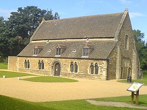
- Lyddington Bede HouseLyddington Bede HouseLyddington Bede House is a historic house in Rutland, England, owned and opened to the public by English Heritage.The existing Grade I listed building is a part of a former palace of the Bishops of Lincoln, situated next to the church in the village of Lyddington.After the Reformation, ownership...

- Normanton Hall
- OakhamOakham-Oakham's horseshoes:Traditionally, members of royalty and peers of the realm who visited or passed through the town had to pay a forfeit in the form of a horseshoe...
Buttercross - OakhamOakham-Oakham's horseshoes:Traditionally, members of royalty and peers of the realm who visited or passed through the town had to pay a forfeit in the form of a horseshoe...
Castle - Rutland County MuseumRutland County MuseumRutland County Museum is located in Oakham, Rutland, in the old Riding School of the Rutland Fencible Cavalry which was built in 1794-95. The museum, opened in 1969, houses a collection of objects relating to local rural and agricultural life, social history and archaeology. Temporary exhibitions...
, OakhamOakham-Oakham's horseshoes:Traditionally, members of royalty and peers of the realm who visited or passed through the town had to pay a forfeit in the form of a horseshoe...

- Rutland Railway MuseumRutland Railway MuseumRutland Railway Museum now trading as Rocks by Rail: The Living Ironstone Museum is a heritage railway on part of a former Midland Railway mineral branch line. It is situated NE of Oakham, in Rutland, England.-Overview:...
, AshwellAshwell, RutlandAshwell is a village and civil parish in the county of Rutland in the East Midlands of England. It is located about three miles north of Oakham....
- Rutland WaterRutland WaterRutland Water is Anglian Water's drinking water reservoir in the county of Rutland, England, just east of the county town Oakham. It was known as Empingham Reservoir during its construction and until its official opening in 1976. The centre of its dam is at British national grid reference...

- Stapleford Miniature RailwayStapleford Miniature RailwayStapleford Miniature Railway is a historic steam locomotive-hauled gauge railway at Stapleford Park, Stapleford near Melton Mowbray in Leicestershire, England....
, Nr WhissendineStapleford, LeicestershireStapleford is a village in the Melton district of Leicestershire, England, east of Melton Mowbray. It is just south of the River Eye, and is part of the civil parish of Freeby....
- Tolethorpe HallTolethorpe HallTolethope Hall in the parish of Little Casterton, Rutland, England, PE9 4BH is a country house near Stamford, Lincolnshire at . It is now the location of the Rutland Theatre of the Stamford Shakespeare Company....
- Wardley Wood

- Whissendine Windmill
See also
- Flag of RutlandFlag of RutlandThe Flag of Rutland is a banner of the arms of the Rutland County Council.The arms were granted to Rutland County Council in 1950. The description of these is: Vert, semée of acorns, a horsehoe Or. Crest: on a wreath of the colours, in front of a horseshoe an acorn Or, leaved and slipped proper...
- Lord Lieutenant of RutlandLord Lieutenant of RutlandThis is a list of people who have served as Lord-Lieutenant of Rutland. The post was abolished on 31 March 1974, with the area coming under the Lord Lieutenant of Leicestershire, but revived in 1997...
- High Sheriff of RutlandHigh Sheriff of RutlandThis is a list of High Sheriffs of Rutland. The High Sheriff is the oldest secular office under the Crown: there has been a Sheriff of Rutland since 1129...
- List of birds of Leicestershire and Rutland