

Geology of New Zealand
Encyclopedia
Earthquake
An earthquake is the result of a sudden release of energy in the Earth's crust that creates seismic waves. The seismicity, seismism or seismic activity of an area refers to the frequency, type and size of earthquakes experienced over a period of time...
s and geothermal
Geothermal
Geothermal is related to energy and may refer to:* The geothermal gradient and associated heat flows from within the Earth- Renewable technology :...
areas
Geothermal areas in New Zealand
New Zealand is a geologically active country with numerous geothermal features, including volcanoes, hot springs, geysers and volcanic lakes. Many of these features are clustered together, and they are particularly abundant throughout the central North Island's Taupo Volcanic Zone...
because of its position on the boundary of the Australian Plate and Pacific Plate
Pacific Plate
The Pacific Plate is an oceanic tectonic plate that lies beneath the Pacific Ocean. At 103 million square kilometres, it is the largest tectonic plate....
s.
New Zealand
New Zealand
New Zealand is an island country in the south-western Pacific Ocean comprising two main landmasses and numerous smaller islands. The country is situated some east of Australia across the Tasman Sea, and roughly south of the Pacific island nations of New Caledonia, Fiji, and Tonga...
was earlier part of the super-continent of Gondwana
Gondwana
In paleogeography, Gondwana , originally Gondwanaland, was the southernmost of two supercontinents that later became parts of the Pangaea supercontinent. It existed from approximately 510 to 180 million years ago . Gondwana is believed to have sutured between ca. 570 and 510 Mya,...
, along with South America
South America
South America is a continent situated in the Western Hemisphere, mostly in the Southern Hemisphere, with a relatively small portion in the Northern Hemisphere. The continent is also considered a subcontinent of the Americas. It is bordered on the west by the Pacific Ocean and on the north and east...
, Africa
Africa
Africa is the world's second largest and second most populous continent, after Asia. At about 30.2 million km² including adjacent islands, it covers 6% of the Earth's total surface area and 20.4% of the total land area...
, Madagascar
Madagascar
The Republic of Madagascar is an island country located in the Indian Ocean off the southeastern coast of Africa...
, India
India
India , officially the Republic of India , is a country in South Asia. It is the seventh-largest country by geographical area, the second-most populous country with over 1.2 billion people, and the most populous democracy in the world...
, Antarctica and Australia
Australia
Australia , officially the Commonwealth of Australia, is a country in the Southern Hemisphere comprising the mainland of the Australian continent, the island of Tasmania, and numerous smaller islands in the Indian and Pacific Oceans. It is the world's sixth-largest country by total area...
. The rocks that now form New Zealand were nestled between Eastern Australia and Western Antarctica.
Basement rocks
The oldest rocks in New Zealand date from mid CambrianCambrian
The Cambrian is the first geological period of the Paleozoic Era, lasting from Mya ; it is succeeded by the Ordovician. Its subdivisions, and indeed its base, are somewhat in flux. The period was established by Adam Sedgwick, who named it after Cambria, the Latin name for Wales, where Britain's...
times (510 Ma), although there are older rocks in the Auckland Islands
Auckland Islands
The Auckland Islands are an archipelago of the New Zealand Sub-Antarctic Islands and include Auckland Island, Adams Island, Enderby Island, Disappointment Island, Ewing Island, Rose Island, Dundas Island and Green Island, with a combined area of...
. The basement rocks are divided into the “Western Province”, consisting mainly of granite
Granite
Granite is a common and widely occurring type of intrusive, felsic, igneous rock. Granite usually has a medium- to coarse-grained texture. Occasionally some individual crystals are larger than the groundmass, in which case the texture is known as porphyritic. A granitic rock with a porphyritic...
and gneiss
Gneiss
Gneiss is a common and widely distributed type of rock formed by high-grade regional metamorphic processes from pre-existing formations that were originally either igneous or sedimentary rocks.-Etymology:...
, and an “Eastern Province”, consisting mainly of greywacke
Greywacke
Greywacke or Graywacke is a variety of sandstone generally characterized by its hardness, dark color, and poorly sorted angular grains of quartz, feldspar, and small rock fragments or lithic fragments set in a compact, clay-fine matrix. It is a texturally immature sedimentary rock generally found...
and schist
Schist
The schists constitute a group of medium-grade metamorphic rocks, chiefly notable for the preponderance of lamellar minerals such as micas, chlorite, talc, hornblende, graphite, and others. Quartz often occurs in drawn-out grains to such an extent that a particular form called quartz schist is...
. The provinces are further divided into terranes – large slices of crust, that have a different geological history, that have been brought together by tectonic activity (subduction
Subduction
In geology, subduction is the process that takes place at convergent boundaries by which one tectonic plate moves under another tectonic plate, sinking into the Earth's mantle, as the plates converge. These 3D regions of mantle downwellings are known as "Subduction Zones"...
and strike-slip faulting) to form New Zealand.
The plutonic basement rocks are subdivided into the Hohonu, Karamea, Median and Paparoa batholith
Batholith
A batholith is a large emplacement of igneous intrusive rock that forms from cooled magma deep in the Earth's crust...
s, that solidified from magma
Magma
Magma is a mixture of molten rock, volatiles and solids that is found beneath the surface of the Earth, and is expected to exist on other terrestrial planets. Besides molten rock, magma may also contain suspended crystals and dissolved gas and sometimes also gas bubbles. Magma often collects in...
deep in the crust. These rocks form the foundations beneath offshore Taranaki, and the West Coast, Buller
Buller
-People:* Sir Edward Buller, 1st Baronet * James Buller , British politician* Sir Francis Buller, 1st Baronet * Charles Buller , English politician* Walter Buller , New Zealand ornithologist...
, Northwest Nelson
Nelson, New Zealand
Nelson is a city on the eastern shores of Tasman Bay, and is the economic and cultural centre of the Nelson-Tasman region. Established in 1841, it is the second oldest settled city in New Zealand and the oldest in the South Island....
, Fiordland
Fiordland
Fiordland is a geographic region of New Zealand that is situated on the south-western corner of the South Island, comprising the western-most third of Southland. Most of Fiordland is dominated by the steep sides of the snow-capped Southern Alps, deep lakes and its ocean-flooded, steep western valleys...
and Stewart Island. Most New Zealand granites were formed in Devonian
Devonian
The Devonian is a geologic period and system of the Paleozoic Era spanning from the end of the Silurian Period, about 416.0 ± 2.8 Mya , to the beginning of the Carboniferous Period, about 359.2 ± 2.5 Mya...
-Carboniferous
Carboniferous
The Carboniferous is a geologic period and system that extends from the end of the Devonian Period, about 359.2 ± 2.5 Mya , to the beginning of the Permian Period, about 299.0 ± 0.8 Mya . The name is derived from the Latin word for coal, carbo. Carboniferous means "coal-bearing"...
time (380-335 Ma) and Jurassic
Jurassic
The Jurassic is a geologic period and system that extends from about Mya to Mya, that is, from the end of the Triassic to the beginning of the Cretaceous. The Jurassic constitutes the middle period of the Mesozoic era, also known as the age of reptiles. The start of the period is marked by...
-Cretaceous
Cretaceous
The Cretaceous , derived from the Latin "creta" , usually abbreviated K for its German translation Kreide , is a geologic period and system from circa to million years ago. In the geologic timescale, the Cretaceous follows the Jurassic period and is followed by the Paleogene period of the...
time (155-100 Ma). The rocks can be matched to similar rocks in Eastern Australia.
The sedimentary
Sedimentary rock
Sedimentary rock are types of rock that are formed by the deposition of material at the Earth's surface and within bodies of water. Sedimentation is the collective name for processes that cause mineral and/or organic particles to settle and accumulate or minerals to precipitate from a solution....
basement rocks are subdivided into the Western Province Buller and Takaka terranes, and the Eastern Province Brook Street
Brook Street
Brook Street is one of the principal streets on the Grosvenor Estate in the exclusive central London district of Mayfair. It was developed in the first half of the 18th century and runs from Hanover Square to Grosvenor Square. The continuation from Grosvenor Square to Park Lane is called Upper...
, Murihiku, Maitai, Caples, Torlesse Composite (Rakaia and Pahau) and Waipapa
Waipapa
Waipapa is a small township in the Bay of Islands, of Northland New Zealand. It is around 10 minutes drive from Kerikeri,the nearest 'urban' centre to Waipapa, located on State Highway 10. Waipapa itelf is so small, having no supermarket or school, that most people travel into Kerikeri on a daily...
Composite (Morrinsville and Hunua) terranes. The Western Province sedimentary rocks form the foundations beneath the Northwestern portion of the South Island
South Island
The South Island is the larger of the two major islands of New Zealand, the other being the more populous North Island. It is bordered to the north by Cook Strait, to the west by the Tasman Sea, to the south and east by the Pacific Ocean...
, to the West of the Alpine Fault
Alpine Fault
The Alpine Fault is a geological fault, more specifically known as a right-lateral strike-slip fault, that runs almost the entire length of New Zealand's South Island. It forms a transform boundary between the Pacific Plate and the Indo-Australian Plate. Earthquakes along the fault, and the...
, and Fiordland
Fiordland
Fiordland is a geographic region of New Zealand that is situated on the south-western corner of the South Island, comprising the western-most third of Southland. Most of Fiordland is dominated by the steep sides of the snow-capped Southern Alps, deep lakes and its ocean-flooded, steep western valleys...
. The Eastern Province sedimentary rocks form the foundation for the rest of New Zealand. They are mostly composed of greywacke together with argillite
Argillite
An argillite is a fine-grained sedimentary rock composed predominantly of indurated clay particles. Argillaceous rocks are basically lithified muds and oozes. They contain variable amounts of silt-sized particles. The argillites grade into shale when the fissile layering typical of shale is...
.
The Alpine Fault that corresponds to the line of the Southern Alps
Southern Alps
The Southern Alps is a mountain range extending along much of the length of New Zealand's South Island, reaching its greatest elevations near the island's western side...
has separated the basement rocks that used to be adjacent by about 460 km. For example, Nelson and Southland
Southland Region
Southland is New Zealand's southernmost region and is also a district within that region. It consists mainly of the southwestern portion of the South Island and Stewart Island / Rakiura...
used to be adjacent, as were Marlborough and Otago.
In general, the sedimentary basement terranes become younger from West to East across the country, as the newer terranes were scraped off the subducting paleo-Pacific Plate
Pacific Plate
The Pacific Plate is an oceanic tectonic plate that lies beneath the Pacific Ocean. At 103 million square kilometres, it is the largest tectonic plate....
, and accreted
Accretion (geology)
Accretion is a process by which material is added to a tectonic plate or a landmass. This material may be sediment, volcanic arcs, seamounts or other igneous features.-Description:...
to the boundary of Gondwana over hundreds of millions of years.
The Buller and Takaka terranes of the Western Province formed in Cambrian-Devonian time (510-400 Ma) and contain New Zealand’s oldest greywacke.
The Median Batholith represents a long-lived batholith dividing the Western and Eastern Provinces, and before the separation of Gondwana, stretched from Queensland
Queensland
Queensland is a state of Australia, occupying the north-eastern section of the mainland continent. It is bordered by the Northern Territory, South Australia and New South Wales to the west, south-west and south respectively. To the east, Queensland is bordered by the Coral Sea and Pacific Ocean...
, through what is now New Zealand, into West Antarctica. It marks the site of a former subduction zone on the edge of Gondwana.
The Central Arc Terranes (Brook Street, Murihiku and Maitai Terranes) are of Carboniferous-Jurassic age (310-165 Ma), and are believed to be related to ancient volcanic arcs. They contain sandstone
Sandstone
Sandstone is a sedimentary rock composed mainly of sand-sized minerals or rock grains.Most sandstone is composed of quartz and/or feldspar because these are the most common minerals in the Earth's crust. Like sand, sandstone may be any colour, but the most common colours are tan, brown, yellow,...
and mudstone
Mudstone
Mudstone is a fine grained sedimentary rock whose original constituents were clays or muds. Grain size is up to 0.0625 mm with individual grains too small to be distinguished without a microscope. With increased pressure over time the platey clay minerals may become aligned, with the...
derived from volcanic rock, and some limestone
Limestone
Limestone is a sedimentary rock composed largely of the minerals calcite and aragonite, which are different crystal forms of calcium carbonate . Many limestones are composed from skeletal fragments of marine organisms such as coral or foraminifera....
. The Brook Street terrane contains Glossopteris
Glossopteris
Glossopteris is the largest and best-known genus of the extinct order of seed ferns known as Glossopteridales ....
fossils, linking New Zealand to Gondwana. The Maitai terrane includes the Dun Mountain Ophiolite Belt, which contains dark serpentinised ultramafic rocks. These rocks form a line (split by the Alpine Fault) throughout the length of the country that can be detected by the magnetic anomaly
Magnetic anomaly
In geophysics, a magnetic anomaly is a local variation in the Earth's magnetic field resulting from variations in the chemistry or magnetism of the rocks. Mapping of variation over an area is valuable in detecting structures obscured by overlying material...
it produces. Ophiolites are slices of oceanic crust
Oceanic crust
Oceanic crust is the part of Earth's lithosphere that surfaces in the ocean basins. Oceanic crust is primarily composed of mafic rocks, or sima, which is rich in iron and magnesium...
and magma that have been detached from a subducting plate, and obducted
Obduction
Obduction is the overthrusting of continental crust by oceanic crust or mantle rocks at a convergent plate boundary. It can occur during an orogeny, or mountain-building episode....
onto the continental crust
Continental crust
The continental crust is the layer of igneous, sedimentary, and metamorphic rocks which form the continents and the areas of shallow seabed close to their shores, known as continental shelves. This layer is sometimes called sial due to more felsic, or granitic, bulk composition, which lies in...
above the subduction zone.
The Caples, Torlesse Composite (Rakaia and Pahau) and Waipapa Composite (Morrinsville and Hunua) terranes formed in Carboniferous-Cretaceous time (330-120 Ma). Much of the rocks were deposited as submarine fans. They have different origins, as shown by different chemical compositions and different fossils.
Many rocks in the Western Province (Paparoa
Paparoa
Paparoa is a settlement in Northland, New Zealand. The Paparoa Stream flows from the east, through the settlement, and into the Paparoa Creek to the south, which joins the Arapaoa River which is part of the Kaipara Harbour. State Highway 12 passes through Paparoa...
, Fiordland and Stewart Island) have been metamorphosed
Metamorphism
Metamorphism is the solid-state recrystallization of pre-existing rocks due to changes in physical and chemical conditions, primarily heat, pressure, and the introduction of chemically active fluids. Mineralogical, chemical and crystallographic changes can occur during this process...
into gneiss
Gneiss
Gneiss is a common and widely distributed type of rock formed by high-grade regional metamorphic processes from pre-existing formations that were originally either igneous or sedimentary rocks.-Etymology:...
. Many rocks in the Eastern Province have been metamorphosed into schist, due to exposure to high pressures and temperatures. Rocks grade continuously from greywacke (e.g., in Canterbury) to high-grade schist (e.g., around the Caples-Torlesse boundary in Otago
Otago
Otago is a region of New Zealand in the south of the South Island. The region covers an area of approximately making it the country's second largest region. The population of Otago is...
and Marlborough, and Torlesse rocks just to the East of the Alpine Fault).
Refer to the GNS Map of New Zealand's Geological Foundations.GNS Map of New Zealand's Geological Foundations
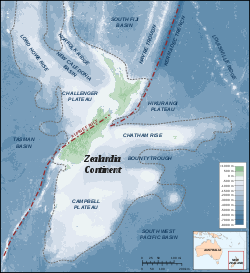
Separation from Gondwana
New ZealandNew Zealand
New Zealand is an island country in the south-western Pacific Ocean comprising two main landmasses and numerous smaller islands. The country is situated some east of Australia across the Tasman Sea, and roughly south of the Pacific island nations of New Caledonia, Fiji, and Tonga...
and New Caledonia
New Caledonia
New Caledonia is a special collectivity of France located in the southwest Pacific Ocean, east of Australia and about from Metropolitan France. The archipelago, part of the Melanesia subregion, includes the main island of Grande Terre, the Loyalty Islands, the Belep archipelago, the Isle of...
represent the visible part of a portion of continental crust
Continental crust
The continental crust is the layer of igneous, sedimentary, and metamorphic rocks which form the continents and the areas of shallow seabed close to their shores, known as continental shelves. This layer is sometimes called sial due to more felsic, or granitic, bulk composition, which lies in...
, usually referred to as Zealandia
Zealandia (continent)
Zealandia , also known as Tasmantis or the New Zealand continent, is a nearly submerged continental fragment that sank after breaking away from Australia 60–85 million years ago, having separated from Antarctica between 85 and 130 million years ago...
. The rest of Zealandia includes the Challenger Plateau
Challenger Plateau
The Challenger Plateau is a large submarine plateau west of New Zealand and south of the Lord Howe Rise. It has an approximate diameter of . The plateau originated in the Gondwanan breakup and is one of the five major submerged parts of Zealandia, a largely submerged continent....
and Lord Howe Rise
Lord Howe Rise
The Lord Howe Rise is an underwater plateau that extends from southwest of New Caledonia to the Challenger Plateau, west of New Zealand. To its west is the Tasman Basin and to the east is the New Caledonia Basin. Lord Howe Rise has a total area of about 1,500,000 square km, and generally lies about...
, which stretch from Northwest of New Zealand almost to Northern Australia, and the Campbell Plateau
Campbell Plateau
The Campbell Plateau is a large submarine plateau to the south of New Zealand and the Chatham Rise. It originated in the Gondwanan breakup and is part of Zealandia, a largely submerged continent. The Bounty Islands, Antipodes Islands, Auckland Islands and Campbell Island are on the...
and Chatham Rise
Chatham Rise
The Chatham Rise is an area of ocean floor to the east of New Zealand, forming part of the Zealandia continent. It stretches for some from near the South Island in the west, to the Chatham Islands in the east...
, to the southeast of New Zealand.
The Australia-New Zealand continental fragment of Gondwana split from the rest of Gondwana in the late Cretaceous time (95-90 Ma). Then around 83 Ma, Zealandia started to separate from Australia forming the Tasman Sea
Tasman Sea
The Tasman Sea is the large body of water between Australia and New Zealand, approximately across. It extends 2,800 km from north to south. It is a south-western segment of the South Pacific Ocean. The sea was named after the Dutch explorer Abel Janszoon Tasman, the first recorded European...
, initially separating from the south. By 75 Ma, Zealandia was essentially separate from Australia and Antarctica, although only shallow seas might have separated Zealandia and Australia in the north. The landmasses continued to separate until early Eocene
Eocene
The Eocene Epoch, lasting from about 56 to 34 million years ago , is a major division of the geologic timescale and the second epoch of the Paleogene Period in the Cenozoic Era. The Eocene spans the time from the end of the Palaeocene Epoch to the beginning of the Oligocene Epoch. The start of the...
times (53 Ma). The Tasman Sea, and part of Zealandia then locked together with Australia to form the Australian Plate (40 Ma), and a new plate boundary was created between the Australian Plate and Pacific Plate
Pacific Plate
The Pacific Plate is an oceanic tectonic plate that lies beneath the Pacific Ocean. At 103 million square kilometres, it is the largest tectonic plate....
. Zealandia ended up at a pivot point between the Pacific and Australian Plates, with spreading in the south, and convergence in the north, where the Pacific Plate was subducted beneath the Australian Plate. A precursor to the Kermadec Arc was created. The convergent part of the plate boundary propagated through Zealandia from the north, eventually forming a proto-Alpine Fault in Miocene
Miocene
The Miocene is a geological epoch of the Neogene Period and extends from about . The Miocene was named by Sir Charles Lyell. Its name comes from the Greek words and and means "less recent" because it has 18% fewer modern sea invertebrates than the Pliocene. The Miocene follows the Oligocene...
times (23 Ma). The various ridges and basins north of New Zealand relate to previous positions of the plate boundary.
Astride a plate boundary
New Zealand is currently astride the convergent boundary between the Pacific and Australian Plates. The Pacific Plate is subducted beneath the Australian Plate from around SamoaSamoa
Samoa , officially the Independent State of Samoa, formerly known as Western Samoa is a country encompassing the western part of the Samoan Islands in the South Pacific Ocean. It became independent from New Zealand in 1962. The two main islands of Samoa are Upolu and one of the biggest islands in...
and Tonga
Tonga
Tonga, officially the Kingdom of Tonga , is a state and an archipelago in the South Pacific Ocean, comprising 176 islands scattered over of ocean in the South Pacific...
in the north, through the Tonga Trench
Tonga Trench
The Tonga Trench is located in the South Pacific Ocean and is deep at its deepest point, known as the Horizon Deep.The Tonga Trench is a convergent plate boundary. The trench lies at the northern end of the Kermadec-Tonga Subduction Zone, an active subduction zone where the Pacific Plate is being...
, Kermadec Trench
Kermadec Trench
The Kermadec trench is one of Earth's deepest oceanic trenches, reaching a depth of . Formed by the subduction of the Pacific Plate under the Indo-Australian Plate, it runs over a thousand kilometres parallel with and to the east of the Kermadec Ridge and island arc, from near the northeastern tip...
, and Hikurangi Trough to the east of the North Island
North Island
The North Island is one of the two main islands of New Zealand, separated from the much less populous South Island by Cook Strait. The island is in area, making it the world's 14th-largest island...
of New Zealand, down to Cook Strait
Cook Strait
Cook Strait is the strait between the North and South Islands of New Zealand. It connects the Tasman Sea on the west with the South Pacific Ocean on the east....
, and the Marlborough Sounds
Marlborough Sounds
The Marlborough Sounds are an extensive network of sea-drowned valleys created by a combination of land subsidence and rising sea levels at the north of the South Island of New Zealand...
and Kaikoura
Kaikoura
Kaikoura is a town on the east coast of the South Island of New Zealand. It is located on State Highway 1 180 km north of Christchurch.Kaikoura became the first local authority to reach the Green Globe tourism certification standard....
region. Through most of the South Island
South Island
The South Island is the larger of the two major islands of New Zealand, the other being the more populous North Island. It is bordered to the north by Cook Strait, to the west by the Tasman Sea, to the south and east by the Pacific Ocean...
, the plates slide past each other, with slight obduction
Obduction
Obduction is the overthrusting of continental crust by oceanic crust or mantle rocks at a convergent plate boundary. It can occur during an orogeny, or mountain-building episode....
of the Pacific Plate over the Australian Plate, forming the Alpine Fault
Alpine Fault
The Alpine Fault is a geological fault, more specifically known as a right-lateral strike-slip fault, that runs almost the entire length of New Zealand's South Island. It forms a transform boundary between the Pacific Plate and the Indo-Australian Plate. Earthquakes along the fault, and the...
and Southern Alps
Southern Alps
The Southern Alps is a mountain range extending along much of the length of New Zealand's South Island, reaching its greatest elevations near the island's western side...
. From Fiordland
Fiordland
Fiordland is a geographic region of New Zealand that is situated on the south-western corner of the South Island, comprising the western-most third of Southland. Most of Fiordland is dominated by the steep sides of the snow-capped Southern Alps, deep lakes and its ocean-flooded, steep western valleys...
south, the Australian Plate subducts under the Pacific Plate forming the Puysegur Trench
Puysegur trench
The deep Puysegur Trench is a deep cleft in the floor of the south Tasman Sea formed by the subduction of the Indo-Australian Plate under the Pacific Plate to the south of New Zealand. Immediately to its east lies a ridge, a northern extension of the Macquarie Ridge, which separates the Puysegur...
.
Over time, the position of the plate boundary has altered. Around 23 Ma, the convergent plate boundary formed Northland
Northland (New Zealand electorate)
Northland is a New Zealand Parliamentary electorate, returning one Member of Parliament to the New Zealand House of Representatives. The electorate was established for the 1996 election and is currently not represented, after the only MP for the electorate so far, John Carter of the National Party,...
. Around 10 Ma, the Coromandel Range
Coromandel Range
right|thumb|250px|A true-colour image showing Auckland city , the Hauraki Gulf and the Coromandel Peninsula . The scene was acquired by NASA's Terra satellite, on October 23, 2002.The Coromandel Range is a ridge of rugged hills running the length of the Coromandel Peninsula in the North Island of...
s were formed. Activity has now moved further East, generating the Kermadec Ridge and Trench, and the Taupo Volcanic Zone
Taupo Volcanic Zone
The Taupo Volcanic Zone is a highly active volcanic V shaped area in the North Island of New Zealand that is spreading east -west at the rate of about 8mm per year...
. The Southern Alps are quite recent, only forming in the last 10 million years.
Land movement
Because New Zealand straddles a plate boundary, it is tectonically active. The Pacific Plate is colliding with the Australian Plate at a rate of about 40 mm/yr.The East coast of the North Island is being compressed and lifted by this collision, producing the North Island and Marlborough Fault System
Marlborough Fault System
The Marlborough Fault System is a set of four large dextral strike-slip faults and other related structures in the northern part of South Island, New Zealand, which transfer displacement between the mainly transform plate boundary of the Alpine fault and the mainly destructive boundary of the...
s. The East Coast of the North Island is also rotating clockwise, relative to Northland, Auckland
Auckland
The Auckland metropolitan area , in the North Island of New Zealand, is the largest and most populous urban area in the country with residents, percent of the country's population. Auckland also has the largest Polynesian population of any city in the world...
and Taranaki, stretching the Bay of Plenty
Bay of Plenty
The Bay of Plenty , often abbreviated to BOP, is a region in the North Island of New Zealand situated around the body of water of the same name...
, and producing the Hauraki Rift (Hauraki Plains and Hauraki Gulf) and Taupo Volcanic Zone
Taupo Volcanic Zone
The Taupo Volcanic Zone is a highly active volcanic V shaped area in the North Island of New Zealand that is spreading east -west at the rate of about 8mm per year...
.
The East Coast of the South Island is sliding obliquely towards the Alpine Fault, relative to Westland
Westland District
Westland District is a territorial authority on the west coast of New Zealand's South Island. Its population is - Government :The Westland District is governed by an elected Council, headed by an elected Mayor. The Mayor is elected at large. The current Mayor is Maureen Pugh. Councillors are...
, causing the Southern Alps to rise about 10 mm/yr (although they are also worn down at a similar rate).
The Hauraki Plains
Hauraki Plains
The Hauraki Plains are a geographical feature and non-administrative area located in the northern North Island of New Zealand, at the lower end of the Thames Valley...
, Hamilton
Hamilton, New Zealand
Hamilton is the centre of New Zealand's fourth largest urban area, and Hamilton City is the country's fourth largest territorial authority. Hamilton is in the Waikato Region of the North Island, approximately south of Auckland...
, Bay of Plenty, Marlborough Sounds
Marlborough Sounds
The Marlborough Sounds are an extensive network of sea-drowned valleys created by a combination of land subsidence and rising sea levels at the north of the South Island of New Zealand...
, and Christchurch
Christchurch
Christchurch is the largest city in the South Island of New Zealand, and the country's second-largest urban area after Auckland. It lies one third of the way down the South Island's east coast, just north of Banks Peninsula which itself, since 2006, lies within the formal limits of...
are sinking. The Marlborough Sounds are known for their sunken mountain ranges. As Wellington
Wellington
Wellington is the capital city and third most populous urban area of New Zealand, although it is likely to have surpassed Christchurch due to the exodus following the Canterbury Earthquake. It is at the southwestern tip of the North Island, between Cook Strait and the Rimutaka Range...
rises, and Marlborough sinks, Cook Strait
Cook Strait
Cook Strait is the strait between the North and South Islands of New Zealand. It connects the Tasman Sea on the west with the South Pacific Ocean on the east....
is being shifted further south.
Earthquakes
Deep earthquakes originate in the subducted plate. Because the Pacific Plate is subducting under the eastern side of the North Island, there are frequent deep earthquakes east of a line from the Bay of Plenty to Nelson (the approximate edge of the subducted plate), with the earthquakes being deeper to the west, and shallower to the east. Because the Australian Plate is subducting under the Pacific Plate in FiordlandFiordland
Fiordland is a geographic region of New Zealand that is situated on the south-western corner of the South Island, comprising the western-most third of Southland. Most of Fiordland is dominated by the steep sides of the snow-capped Southern Alps, deep lakes and its ocean-flooded, steep western valleys...
, there are frequent deep earthquakes near Fiordland, with the earthquakes being deeper to the east and shallower near the west. There are few deep earthquakes along the Southern Alps
Southern Alps
The Southern Alps is a mountain range extending along much of the length of New Zealand's South Island, reaching its greatest elevations near the island's western side...
, because the two sides largely slide past each other.
Shallow earthquakes are caused by stresses in the top plate. Shallow earthquakes are more widespread, occurring almost everywhere throughout New Zealand (especially the Bay of Plenty, East Cape
East Cape
East Cape is the easternmost point of the main islands of New Zealand. It is located to the north of Gisborne in the northeast of the North Island....
to Marlborough, and Alpine Fault). However, Northland, Waikato
Waikato
The Waikato Region is a local government region of the upper North Island of New Zealand. It covers the Waikato, Hauraki, Coromandel Peninsula, the northern King Country, much of the Taupo District, and parts of Rotorua District...
, and Otago
Otago
Otago is a region of New Zealand in the south of the South Island. The region covers an area of approximately making it the country's second largest region. The population of Otago is...
are very stable. Canterbury
Canterbury, New Zealand
The New Zealand region of Canterbury is mainly composed of the Canterbury Plains and the surrounding mountains. Its main city, Christchurch, hosts the main office of the Christchurch City Council, the Canterbury Regional Council - called Environment Canterbury - and the University of Canterbury.-...
had been very stable until the 7.1 Canterbury Earthquake
2010 Canterbury earthquake
The 2010 Canterbury earthquake was a 7.1 magnitude earthquake, which struck the South Island of New Zealand at 4:35 am on local time ....
on 4 September 2010. In the first three weeks following that quake, there were more than 1000 aftershocks in the region.
A Map showing the distribution of earthquakes in New Zealand can be obtained from Te Ara Encyclopedia of New Zealand.
Current earthquake and volcanic activity can be obtained from the GeoNet website.
Northland and East Cape allochthons
An allochthonAllochthon
thumb|right|250px|Schematic overview of a thrust system. The hanging wall block is called a [[nappe]]. If an [[erosion]]al hole is created in the nappe that is called a [[window |window]]...
is land that formed elsewhere, and slid on top of other land (in other words, the material of an enormous landslide). Much of the land of Northland and East Cape
East Cape
East Cape is the easternmost point of the main islands of New Zealand. It is located to the north of Gisborne in the northeast of the North Island....
were created in this manner. Around 25-22 Ma, Northland and East Cape were adjacent, with East Cape near Whangarei
Whangarei
Whangarei, pronounced , is the northernmost city in New Zealand and the regional capital of Northland Region. Although commonly classified as a city, it is officially part of the Whangarei District, administered by the Whangarei District Council a local body created in 1989 to administer both the...
. Northland-East Cape was an undersea basin. Much of the land that now forms Northland-East Cape was higher land to the Northeast (composed of rocks formed 90-25 Ma). The Pacific-Australian plate boundary was further to the Northeast, with the Pacific Plate subducting under the Australian Plate. Layers of rocks were peeled off the higher land, from the top down, and slid Southwest under the influence of gravity, to be stacked the right way up, but in reverse order. The last rocks to be slid across were slabs of oceanic crust
Oceanic crust
Oceanic crust is the part of Earth's lithosphere that surfaces in the ocean basins. Oceanic crust is primarily composed of mafic rocks, or sima, which is rich in iron and magnesium...
, mainly basalt
Basalt
Basalt is a common extrusive volcanic rock. It is usually grey to black and fine-grained due to rapid cooling of lava at the surface of a planet. It may be porphyritic containing larger crystals in a fine matrix, or vesicular, or frothy scoria. Unweathered basalt is black or grey...
. Widespread volcanic activity also occurred (23-15 Ma), and is intermixed with the foreign rocks. East Cape was later separated from Northland and moved further south and east to its present position.
Sedimentary basins
Much of New Zealand was low lying around Mid EoceneEocene
The Eocene Epoch, lasting from about 56 to 34 million years ago , is a major division of the geologic timescale and the second epoch of the Paleogene Period in the Cenozoic Era. The Eocene spans the time from the end of the Palaeocene Epoch to the beginning of the Oligocene Epoch. The start of the...
-Oligocene
Oligocene
The Oligocene is a geologic epoch of the Paleogene Period and extends from about 34 million to 23 million years before the present . As with other older geologic periods, the rock beds that define the period are well identified but the exact dates of the start and end of the period are slightly...
times (40-23 Ma). Swamps became widespread, forming coal
Coal
Coal is a combustible black or brownish-black sedimentary rock usually occurring in rock strata in layers or veins called coal beds or coal seams. The harder forms, such as anthracite coal, can be regarded as metamorphic rock because of later exposure to elevated temperature and pressure...
. The land subsided further, and marine organisms produced limestone
Limestone
Limestone is a sedimentary rock composed largely of the minerals calcite and aragonite, which are different crystal forms of calcium carbonate . Many limestones are composed from skeletal fragments of marine organisms such as coral or foraminifera....
deposits. Limestone of Oligocene-Early Miocene
Miocene
The Miocene is a geological epoch of the Neogene Period and extends from about . The Miocene was named by Sir Charles Lyell. Its name comes from the Greek words and and means "less recent" because it has 18% fewer modern sea invertebrates than the Pliocene. The Miocene follows the Oligocene...
age formed in many areas, including the King Country
King Country
The King Country is a region of the western North Island of New Zealand. It extends approximately from the Kawhia Harbour and the town of Otorohanga in the north to the upper reaches of the Whanganui River in the south, and from the Hauhungaroa and Rangitoto Ranges in the east to near the Tasman...
, known for the Waitomo Glowworm Cave
Waitomo Glowworm Cave
The Waitomo Glowworm Caves attraction is a cave at Waitomo on the North Island of New Zealand, known for its population of glowworms, Arachnocampa luminosa. These glowworms are found exclusively in New Zealand and around the size of an average mosquito...
. In the South Island, limestone is present in Buller
Buller
-People:* Sir Edward Buller, 1st Baronet * James Buller , British politician* Sir Francis Buller, 1st Baronet * Charles Buller , English politician* Walter Buller , New Zealand ornithologist...
, Nelson, and the West Coast, including the Pancake Rocks at Punakaiki
Punakaiki
Punakaiki is a small community on the West Coast of the South Island of New Zealand, between Westport and Greymouth. The community lies on the edge of the Paparoa National Park....
in Oligocene-Early Miocene times (34-15 Ma). Many of New Zealand's limestone deposits were formed in relatively cool seas.
Volcanic activity
When a plate is subducted under another plate, it causes melting in the mantle, the layer of the earth below the crust, and produces a volcanic arcVolcanic arc
A volcanic arc is a chain of volcanoes positioned in an arc shape as seen from above. Offshore volcanoes form islands, resulting in a volcanic island arc. Generally they result from the subduction of an oceanic tectonic plate under another tectonic plate, and often parallel an oceanic trench...
, composed of mainly andesitic and rhyolitic volcanoes in New Zealand, but often widely varying in composition depending on the type of island arc. Andesitic eruptions tend to form steep stratovolcanoes, including mountains such as Ruapehu
Mount Ruapehu
Mount Ruapehu, or just Ruapehu, is an active stratovolcano at the southern end of the Taupo Volcanic Zone in New Zealand. It is 23 kilometres northeast of Ohakune and 40 kilometres southwest of the southern shore of Lake Taupo, within Tongariro National Park...
, Tongariro and Taranaki, islands such as Little Barrier, White and Raoul Island
Raoul Island
Anvil-shaped Raoul Island , the largest and northernmost of the main Kermadec Islands, , has been the source of vigorous volcanic activity during the past several thousand years that was dominated by dacitic explosive eruptions.The area of the island, including fringing islets and rocks...
s, or submarine seamount
Seamount
A seamount is a mountain rising from the ocean seafloor that does not reach to the water's surface , and thus is not an island. These are typically formed from extinct volcanoes, that rise abruptly and are usually found rising from a seafloor of depth. They are defined by oceanographers as...
s like Monowai Seamount
Monowai Seamount
Monowai is a volcanic seamount to the north of New Zealand. It is one of the most active volcanoes in the Kermadec volcanic arc.The most recent eruption was in 2008....
. Rhyolitic eruptions with large amounts of water tend to cause violent eruptions, producing calderas, such as Lake Taupo
Lake Taupo
Lake Taupo is a lake situated in the North Island of New Zealand. With a surface area of , it is the largest lake by surface area in New Zealand, and the second largest freshwater lake by surface area in geopolitical Oceania after Lake Murray ....
and Lake Rotorua
Lake Rotorua
Lake Rotorua is the second largest lake in the North Island of New Zealand by surface area, and covers 79.8km2. With a mean depth of only 10 metres it is considerably smaller than nearby Lake Tarawera in terms of volume of water. It is located in the Bay of Plenty region...
. Basaltic volcanoes tend to form at intra-plate hot spots. Basaltic eruptions tend to be fairly placid, producing scoria cones and lava flows, such as the volcanic cones in the Auckland Volcanic Field
Auckland Volcanic Field
The Auckland volcanic field is a monogenetic volcanic field in the North Island of New Zealand. Basaltic in nature, it underlies much of the metropolitan area of Auckland....
, although Mount Tarawera
Mount Tarawera
Mount Tarawera is the volcano responsible for New Zealand's largest historic eruption. Located 24 kilometres southeast of Rotorua in the North Island, it consists of a series of rhyolitic lava domes that were fissured down the middle by an explosive basaltic eruption in 1886, which killed over...
's violent 1886 eruption was an exception.
The South Island has no currently active volcanoes. However, in the late Cretaceous
Cretaceous
The Cretaceous , derived from the Latin "creta" , usually abbreviated K for its German translation Kreide , is a geologic period and system from circa to million years ago. In the geologic timescale, the Cretaceous follows the Jurassic period and is followed by the Paleogene period of the...
(100-65 Ma), there was widespread volcanic activity in Marlborough, West Coast, Canterbury and Otago; and in Eocene
Eocene
The Eocene Epoch, lasting from about 56 to 34 million years ago , is a major division of the geologic timescale and the second epoch of the Paleogene Period in the Cenozoic Era. The Eocene spans the time from the end of the Palaeocene Epoch to the beginning of the Oligocene Epoch. The start of the...
times (40 Ma), there was volcanic activity in Oamaru
Oamaru
Oamaru , the largest town in North Otago, in the South Island of New Zealand, is the main town in the Waitaki District. It is 80 kilometres south of Timaru and 120 kilometres north of Dunedin, on the Pacific coast, and State Highway 1 and the railway Main South Line connects it to both...
. The most well known Miocene
Miocene
The Miocene is a geological epoch of the Neogene Period and extends from about . The Miocene was named by Sir Charles Lyell. Its name comes from the Greek words and and means "less recent" because it has 18% fewer modern sea invertebrates than the Pliocene. The Miocene follows the Oligocene...
volcanic centres are the Otago
Otago Peninsula
The Otago Peninsula is a long, hilly indented finger of land that forms the easternmost part of Dunedin, New Zealand. Volcanic in origin, it forms one wall of the eroded valley that now forms Otago Harbour. The peninsula lies south-east of Otago Harbour and runs parallel to the mainland for...
and Banks Peninsula
Banks Peninsula
Banks Peninsula is a peninsula of volcanic origin on the east coast of the South Island of New Zealand. It has an area of approximately and encompasses two large harbours and many smaller bays and coves...
s. The Otago Peninsula near Dunedin
Dunedin
Dunedin is the second-largest city in the South Island of New Zealand, and the principal city of the Otago Region. It is considered to be one of the four main urban centres of New Zealand for historic, cultural, and geographic reasons. Dunedin was the largest city by territorial land area until...
was built up by a series of mainly basaltic intra-plate volcanic eruptions in Miocene times (16-10 Ma). This has resulted in the formation of Port Chalmers
Port Chalmers
Port Chalmers is a suburb and the main port of the city of Dunedin, New Zealand, with a population of 3,000. Port Chalmers lies ten kilometres inside Otago Harbour, some 15 kilometres northeast from Dunedin's city centre....
. Banks Peninsula near Christchurch
Christchurch
Christchurch is the largest city in the South Island of New Zealand, and the country's second-largest urban area after Auckland. It lies one third of the way down the South Island's east coast, just north of Banks Peninsula which itself, since 2006, lies within the formal limits of...
was built from two mainly basaltic intra-plate volcanoes in Miocene times (12-6 Ma and 9.5-7.5 Ma), corresponding to the Lyttelton
Lyttelton Harbour
Lyttelton Harbour is one of two major inlets in Banks Peninsula, on the coast of Canterbury, New Zealand. The other is Akaroa Harbour.Approximately 15 km in length from its mouth to Teddington, the harbour was formed from a series of ancient volcanic eruptions that created a caldera, the...
and Akaroa
Akaroa
Akaroa is a village on Banks Peninsula in the Canterbury region of the South Island of New Zealand, situated within a harbour of the same name—the name Akaroa is Kāi Tahu Māori for 'Long Harbour'.- Overview :...
Harbours. Southland's Solander Islands
Solander Islands
The Solander Islands are a small chain of uninhabited volcanic islets lying at , close to the western end of the Foveaux Strait in southern New Zealand...
were active around 1 to 2 million years ago.
The North Island is home to both old and currently active volcanoes. Over time, volcanic activity has moved south and east, as the plate boundary moved eastward, and the place where subduction changed from the Pacific Plate to the Australian Plate moved south.
A volcanic arc became active to the west of the current land in Northland in Miocene times (23 Ma), and gradually moved South down to New Plymouth
New Plymouth
New Plymouth is the major city of the Taranaki Region on the west coast of the North Island of New Zealand. It is named after Plymouth, Devon, England, from where the first English settlers migrated....
, where Taranaki is still active. It produced mainly andesitic strato-volcanoes. The Northland volcanoes include the volcanoes that produced the Waipoua Plateau (site of Waipoua Forest
Waipoua Forest
Waipoua Forest preserves some of the best examples of kauri forest remaining in New Zealand. It is notable for having two of the largest living kauri trees, Tane Mahuta and Te Matua Ngahere.The forest was declared a sanctuary in 1952....
, with large Kauri trees) and Kaipara
Kaipara
Kaipara can refer to:*Kaipara Harbour, a bay in northern New Zealand**Kaipara River, a river draining into the harbour**Kaipara District, an administrative division centred around the harbour*Kaipara a former Parliamentary electorate...
volcano.
The Waitakere volcano (22-16 Ma) has mainly been eroded, but conglomerate
Conglomerate (geology)
A conglomerate is a rock consisting of individual clasts within a finer-grained matrix that have become cemented together. Conglomerates are sedimentary rocks consisting of rounded fragments and are thus differentiated from breccias, which consist of angular clasts...
from the volcano forms the Waitakere Ranges
Waitakere Ranges
The Waitakere Ranges are a chain of hills in the Auckland metropolitan area, generally running approximately 25 km from north to south, 25 km west of central Auckland, New Zealand. The maximum elevation within the ranges is 474 m...
, and produced most of the material that makes up the Waitemata sandstones and mudstones. Lahars produced the coarser Parnell Grit.
Notable visible volcanoes in the Waikato include Karioi and Pirongia
Pirongia
Pirongia is a small town in the Waipa District of the Waikato region of New Zealand's North Island.It is 12 kilometres to the west of Te Awamutu, on the banks of the Waipa River, close to the foot of the 962 metre Mount Pirongia, which lies in a forest park to the west of the town.Pirongia was...
(2.5 Ma). Taranaki is a perfectly formed andesitic strato-volcano, that last erupted in 1755.
The volcanoes off the West coast of the North Island, together with Taranaki and the Tongariro Volcanic Centre, are responsible for the black iron sand on many of the beaches between Taranaki and Auckland
Auckland
The Auckland metropolitan area , in the North Island of New Zealand, is the largest and most populous urban area in the country with residents, percent of the country's population. Auckland also has the largest Polynesian population of any city in the world...
.
Shortly after (18 Ma), a volcanic arc developed further east to create the Coromandel Range
Coromandel Range
right|thumb|250px|A true-colour image showing Auckland city , the Hauraki Gulf and the Coromandel Peninsula . The scene was acquired by NASA's Terra satellite, on October 23, 2002.The Coromandel Range is a ridge of rugged hills running the length of the Coromandel Peninsula in the North Island of...
s and undersea Colville Ridge. The initial activity was andesitic, but later became rhyolytic (12 Ma). In the Kauaeranga Valley, volcanic plugs remain, as does a lava lake that now forms the top of Table Mountain. Active geothermal systems
Geothermal Systems
A geothermal heat pump, ground source heat pump , or ground heat pump is a central heating and/or cooling system that pumps heat to or from the ground.It uses the earth as a heat source or a heat sink...
, similar to those that now exist near Rotorua
Rotorua
Rotorua is a city on the southern shores of the lake of the same name, in the Bay of Plenty region of the North Island of New Zealand. The city is the seat of the Rotorua District, a territorial authority encompassing the city and several other nearby towns...
, were present around 6 Ma, and produced the gold
Gold
Gold is a chemical element with the symbol Au and an atomic number of 79. Gold is a dense, soft, shiny, malleable and ductile metal. Pure gold has a bright yellow color and luster traditionally considered attractive, which it maintains without oxidizing in air or water. Chemically, gold is a...
and silver
Silver
Silver is a metallic chemical element with the chemical symbol Ag and atomic number 47. A soft, white, lustrous transition metal, it has the highest electrical conductivity of any element and the highest thermal conductivity of any metal...
deposits that were later mine
Mining
Mining is the extraction of valuable minerals or other geological materials from the earth, from an ore body, vein or seam. The term also includes the removal of soil. Materials recovered by mining include base metals, precious metals, iron, uranium, coal, diamonds, limestone, oil shale, rock...
d in the Coromandel gold rush. Later (5-2 Ma), volcanic activity moved further south to form the Kaimai Range.
After this, activity shifted further East to the Taupo Volcanic Zone
Taupo Volcanic Zone
The Taupo Volcanic Zone is a highly active volcanic V shaped area in the North Island of New Zealand that is spreading east -west at the rate of about 8mm per year...
, which runs from the Tongariro Volcanic Centre (Ruapehu
Mount Ruapehu
Mount Ruapehu, or just Ruapehu, is an active stratovolcano at the southern end of the Taupo Volcanic Zone in New Zealand. It is 23 kilometres northeast of Ohakune and 40 kilometres southwest of the southern shore of Lake Taupo, within Tongariro National Park...
and Tongariro), through Taupo
Taupo
Taupo is a town on the shore of Lake Taupo in the centre of the North Island of New Zealand. It is the seat of the Taupo District Council and lies in the southern Waikato Region....
, Rotorua
Rotorua
Rotorua is a city on the southern shores of the lake of the same name, in the Bay of Plenty region of the North Island of New Zealand. The city is the seat of the Rotorua District, a territorial authority encompassing the city and several other nearby towns...
, and out to sea to form the Kermadec Ridge. Activity was initiated around 2 Ma, and continues to this day. The Tongariro Volcanic Centre is composed of andesitic volcanoes, while the areas around Taupo and Rotorua are largely rhyolitic.
The Tongariro Volcanic Centre developed over the last 275,000 years and contains the active andesitic volcanic cones of Ruapehu, Tongariro, and Ngauruhoe (really a side cone of Tongariro). Ruapehu erupts about once a decade, and while the eruptions cause havoc for skiers, plane flights and hydroelectric dams, the eruptions are relatively minor. However, the sudden collapse of the crater wall caused major problems when it generated a lahar
Lahar
A lahar is a type of mudflow or debris flow composed of a slurry of pyroclastic material, rocky debris, and water. The material flows down from a volcano, typically along a river valley. The term is a shortened version of "berlahar" which originated in the Javanese language of...
in 1953, that destroyed a rail bridge, and caused 151 deaths at Tangiwai. The last significant eruption was 1995-96. Ngauruhoe last erupted 1973-75.
Lake Taupo
Lake Taupo
Lake Taupo is a lake situated in the North Island of New Zealand. With a surface area of , it is the largest lake by surface area in New Zealand, and the second largest freshwater lake by surface area in geopolitical Oceania after Lake Murray ....
, the largest lake in the North Island, is a volcanic caldera, responsible for rhyolitic eruptions about once every 1,000 years. The largest eruption in the last 65,000 years was the cataclysmic Oruanui Eruption
Oruanui eruption
The Oruanui eruption of New Zealand's Taupo Volcano was the world's largest known eruption in the past 70,000 years, with a Volcanic Explosivity Index of 8...
26,500 years ago, producing 530 cubic kilometres of magma. The most recent eruption, around 233 AD was also a major event, the biggest eruption worldwide in the last 5,000 years. The eruption caused a pyroclastic flow that devastated the land from Waiouru
Waiouru
Waiouru is a small town in the centre of the North Island of New Zealand. It is on the North Island Volcanic Plateau, 25 kilometres south-east of Mount Ruapehu, and in the Ruapehu District....
to Rotorua
Rotorua
Rotorua is a city on the southern shores of the lake of the same name, in the Bay of Plenty region of the North Island of New Zealand. The city is the seat of the Rotorua District, a territorial authority encompassing the city and several other nearby towns...
in 10 minutes.
The Okataina volcanic centre, to the East of Rotorua, is also responsible for major cataclysmic rhyolitic eruptions. The last eruption, of Tarawera
Mount Tarawera
Mount Tarawera is the volcano responsible for New Zealand's largest historic eruption. Located 24 kilometres southeast of Rotorua in the North Island, it consists of a series of rhyolitic lava domes that were fissured down the middle by an explosive basaltic eruption in 1886, which killed over...
and Lake Rotomahana
Lake Rotomahana
Lake Rotomahana is an lake in northern New Zealand, located 25 kilometres to the east of Rotorua. It is immediately southwest of the dormant volcano Mount Tarawera, and its geography was substantially altered by a major 1886 eruption of Mount Tarawera...
in 1886, was a relatively minor eruption, which destroyed the famous Pink and White Terraces
Pink and White Terraces
The Pink and White Terraces, also called Otukapuarangi or Te Tarata in Māori, were a natural wonder of New Zealand...
, and covered much of the surrounding countryside in ash, killing over 100 people.
Many lakes around Rotorua are calderas from rhyolitic eruptions. For example, Lake Rotorua
Lake Rotorua
Lake Rotorua is the second largest lake in the North Island of New Zealand by surface area, and covers 79.8km2. With a mean depth of only 10 metres it is considerably smaller than nearby Lake Tarawera in terms of volume of water. It is located in the Bay of Plenty region...
erupted around 13,500 years ago.
Earlier eruptions between Taupo and Rotorua around 1.25 Ma, and 1 Ma, were large enough to produce an ignimbrite
Ignimbrite
An ignimbrite is the deposit of a pyroclastic density current, or pyroclastic flow, a hot suspension of particles and gases that flows rapidly from a volcano, driven by a greater density than the surrounding atmosphere....
sheet that reached Auckland
Auckland
The Auckland metropolitan area , in the North Island of New Zealand, is the largest and most populous urban area in the country with residents, percent of the country's population. Auckland also has the largest Polynesian population of any city in the world...
, Napier
Napier, New Zealand
Napier is a New Zealand city with a seaport, located in Hawke's Bay on the eastern coast of the North Island. The population of Napier is about About 18 kilometres south of Napier is the inland city of Hastings. These two neighboring cities are often called "The Twin Cities" or "The Bay Cities"...
, and Gisborne
Gisborne, New Zealand
-Economy:The harbour was host to many ships in the past and had developed as a river port to provide a more secure location for shipping compared with the open roadstead of Poverty Bay which can be exposed to southerly swells. A meat works was sited beside the harbour and meat and wool was shipped...
.
Vast pumice
Pumice
Pumice is a textural term for a volcanic rock that is a solidified frothy lava typically created when super-heated, highly pressurized rock is violently ejected from a volcano. It can be formed when lava and water are mixed. This unusual formation is due to the simultaneous actions of rapid...
deposits generated from eruptions in the Taupo Volcanic Zone occur throughout the central North Island, Bay of Plenty, Waikato
Waikato
The Waikato Region is a local government region of the upper North Island of New Zealand. It covers the Waikato, Hauraki, Coromandel Peninsula, the northern King Country, much of the Taupo District, and parts of Rotorua District...
, King Country
King Country
The King Country is a region of the western North Island of New Zealand. It extends approximately from the Kawhia Harbour and the town of Otorohanga in the north to the upper reaches of the Whanganui River in the south, and from the Hauhungaroa and Rangitoto Ranges in the east to near the Tasman...
and Wanganui
Wanganui
Whanganui , also spelled Wanganui, is an urban area and district on the west coast of the North Island of New Zealand. It is part of the Manawatu-Wanganui region....
regions.
Every so often, there are swarms of earthquakes within an area of the Taupo Volcanic Zone, which last for years. These earthquake swarms indicate that some movement of magma
Magma
Magma is a mixture of molten rock, volatiles and solids that is found beneath the surface of the Earth, and is expected to exist on other terrestrial planets. Besides molten rock, magma may also contain suspended crystals and dissolved gas and sometimes also gas bubbles. Magma often collects in...
is occurring below the surface. While they have not resulted in an eruption in recent times, there is always the potential for a new volcano to be created, or a dormant volcano to come to life.
White Island
Whakaari/White Island
Whakaari/White Island is an active andesite stratovolcano, situated from the east coast of the North Island of New Zealand, in the Bay of Plenty. The nearest mainland towns are Whakatane and Tauranga....
, in the Bay of Plenty, is a very active andesitic volcano, erupting with great frequency. It has the potential to cause a tsunami in the Bay of Plenty, as does the dormant Mayor Island volcano.
A line of undersea volcanoes extends out along the Kermadec Ridge.
Intra-plate basaltic volcanic eruptions occurred near the Bay of Islands
Bay of Islands
The Bay of Islands is an area in the Northland Region of the North Island of New Zealand. Located 60 km north-west of Whangarei, it is close to the northern tip of the country....
in Northland, in the Late Miocene (10 Mya), and again more recently (0.5 Mya). The South Auckland volcanic field was active in Pleistocene
Pleistocene
The Pleistocene is the epoch from 2,588,000 to 11,700 years BP that spans the world's recent period of repeated glaciations. The name pleistocene is derived from the Greek and ....
times (1.5-0.5 Ma). The Auckland Volcanic Field
Auckland Volcanic Field
The Auckland volcanic field is a monogenetic volcanic field in the North Island of New Zealand. Basaltic in nature, it underlies much of the metropolitan area of Auckland....
started around 250,000 years ago, and is still active. It includes around 50 distinct eruptions, with most of the prominent cones formed in the last 30,000 years, and the most recent eruption, which formed Rangitoto Island
Rangitoto Island
Rangitoto Island is a volcanic island in the Hauraki Gulf near Auckland, New Zealand. The 5.5 km wide island is an iconic and widely visible landmark of Auckland with its distinctive symmetrical shield volcano cone rising 260 metres high over the Hauraki Gulf...
, around 600 years ago.
Geothermal activity
The Taupo Volcanic ZoneTaupo Volcanic Zone
The Taupo Volcanic Zone is a highly active volcanic V shaped area in the North Island of New Zealand that is spreading east -west at the rate of about 8mm per year...
is known for its geothermal
Geothermal
Geothermal is related to energy and may refer to:* The geothermal gradient and associated heat flows from within the Earth- Renewable technology :...
activity. For example, Rotorua and the surrounding area have many areas with geysers, silica terraces, fumaroles, mudpools, hot springs
Hot Springs
Hot Springs may refer to:* Hot Springs, Arkansas** Hot Springs National Park, Arkansas*Hot Springs, California**Hot Springs, Lassen County, California**Hot Springs, Modoc County, California**Hot Springs, Placer County, California...
, etc. Notable geothermal areas include Whakarewarewa
Whakarewarewa
Whakarewarewa is a geothermal area within Rotorua city in the Taupo Volcanic Zone of New Zealand...
, Tikitere
Tikitere
Tikitere, also known as "Hell's Gate", is Rotorua's most active geothermal area on State Highway 30, between Lake Rotorua and Lake Rotoiti in the Bay of Plenty, New Zealand...
, Waimangu
Waimangu Volcanic Rift Valley
Waimangu Volcanic Rift Valley is the hydrothermal system created on 10 June 1886 by the volcanic eruption of Mount Tarawera, on the North Island of New Zealand. It encompasses Lake Rotomahana, the former site of the Pink and White Terraces. It was the location of the Waimangu Geyser, which was...
, Waiotapu, Craters of the Moon
Craters of the Moon (geothermal site)
Craters of the Moon Thermal Area is a region with geothermal activity north of Taupo, New Zealand. It is a part of Wairakei, the largest geothermal field in New Zealand, with a surface area of about 25 km2, which lies in the Taupo Volcanic Zone.The name springs from the many hydrothermal eruption...
and Orakei Korako
Orakei Korako
Orakei Korako , is a highly active geothermal area most notable for its series of fault-stepped sinter terraces, located in a valley north of Taupo on the banks of the Waikato River in the Taupo Volcanic Zone, New Zealand...
. Geothermal energy is used to generate electricity at Wairakei
Wairakei
Wairakei is the name of a power station, small settlement and a geothermal area a few kilometres north of Taupo, in the centre of the North Island of New Zealand, on the Waikato River.- Geothermal field :...
, near Taupo
Taupo
Taupo is a town on the shore of Lake Taupo in the centre of the North Island of New Zealand. It is the seat of the Taupo District Council and lies in the southern Waikato Region....
. Hot pools abound throughout New Zealand.
New Zealand in the last glacial maximum
Throughout the last glacial maximumLast Glacial Maximum
The Last Glacial Maximum refers to a period in the Earth's climate history when ice sheets were at their maximum extension, between 26,500 and 19,000–20,000 years ago, marking the peak of the last glacial period. During this time, vast ice sheets covered much of North America, northern Europe and...
, global sea levels were about 130 m lower than present levels. When this happened, North Island, South Island, and Stewart Island were joined together. Temperatures dropped by about 4-5 °C. Much of the Southern Alps
Southern Alps
The Southern Alps is a mountain range extending along much of the length of New Zealand's South Island, reaching its greatest elevations near the island's western side...
and Fiordland
Fiordland
Fiordland is a geographic region of New Zealand that is situated on the south-western corner of the South Island, comprising the western-most third of Southland. Most of Fiordland is dominated by the steep sides of the snow-capped Southern Alps, deep lakes and its ocean-flooded, steep western valleys...
were glaciated, but the rest of New Zealand was largely ice-free. The land to the North of Hamilton
Hamilton, New Zealand
Hamilton is the centre of New Zealand's fourth largest urban area, and Hamilton City is the country's fourth largest territorial authority. Hamilton is in the Waikato Region of the North Island, approximately south of Auckland...
was forested, but much of the rest of New Zealand was covered in grass or shrubs.
Geological hazards
New Zealand suffers from many natural hazards, including earthquakes, volcanic and hydrothermal eruptions, tsunamis, landslides, and floods.The most severe earthquake occurred in a M8.2 earthquake in the Wairarapa
Wairarapa
Wairarapa is a geographical region of New Zealand. It occupies the south-eastern corner of the North Island, east of metropolitan Wellington and south-west of the Hawke's Bay region. It is lightly populated, having several rural service towns, with Masterton being the largest...
, in 1855, and the most deaths (261) in a M7.8 earthquake in Hawkes Bay in 1931. Widespread property damage was caused by the 2010 Canterbury earthquake
2010 Canterbury earthquake
The 2010 Canterbury earthquake was a 7.1 magnitude earthquake, which struck the South Island of New Zealand at 4:35 am on local time ....
, which measured 7.1; however there were no fatalities.
Earthquakes along the East coast of the North Island have the potential to cause tsunami, as do earthquakes in South America.
The most severe eruption since European times is the Tarawera
Mount Tarawera
Mount Tarawera is the volcano responsible for New Zealand's largest historic eruption. Located 24 kilometres southeast of Rotorua in the North Island, it consists of a series of rhyolitic lava domes that were fissured down the middle by an explosive basaltic eruption in 1886, which killed over...
eruption in 1886. However, there are many potentially dangerous volcanoes in the Taupo Volcanic Zone
Taupo Volcanic Zone
The Taupo Volcanic Zone is a highly active volcanic V shaped area in the North Island of New Zealand that is spreading east -west at the rate of about 8mm per year...
. Even a minor eruption at Ruapehu
Mount Ruapehu
Mount Ruapehu, or just Ruapehu, is an active stratovolcano at the southern end of the Taupo Volcanic Zone in New Zealand. It is 23 kilometres northeast of Ohakune and 40 kilometres southwest of the southern shore of Lake Taupo, within Tongariro National Park...
could cause the loss of electricity for Auckland, due to ash on the power lines, and in the Waikato River
Waikato River
The Waikato River is the longest river in New Zealand. In the North Island, it runs for 425 kilometres from the eastern slopes of Mount Ruapehu, joining the Tongariro River system and emptying into Lake Taupo, New Zealand's largest lake. It drains Taupo at the lake's northeastern edge, creates the...
(stopping the generation of hydroelectric power).
Much of the North Island is steep, and composed of soft mudstone, that easily generates landslides.
Parts of New Zealand, especially Northland, Coromandel Peninsula
Coromandel Peninsula
The Coromandel Peninsula lies in the North Island of New Zealand. It is part of the Waikato Region and Thames-Coromandel District and extends 85 kilometres north from the western end of the Bay of Plenty, forming a natural barrier to protect the Hauraki Gulf and the Firth of Thames in the west...
, Bay of Plenty, Gisborne, and the Manawatu can have high rainfall that can generate flooding of farmland.
Geological resources
Iron sand is plentiful on the west coast from Taranaki to AucklandAuckland
The Auckland metropolitan area , in the North Island of New Zealand, is the largest and most populous urban area in the country with residents, percent of the country's population. Auckland also has the largest Polynesian population of any city in the world...
. Gold
Gold
Gold is a chemical element with the symbol Au and an atomic number of 79. Gold is a dense, soft, shiny, malleable and ductile metal. Pure gold has a bright yellow color and luster traditionally considered attractive, which it maintains without oxidizing in air or water. Chemically, gold is a...
has been mined in the Coromandel
Coromandel Range
right|thumb|250px|A true-colour image showing Auckland city , the Hauraki Gulf and the Coromandel Peninsula . The scene was acquired by NASA's Terra satellite, on October 23, 2002.The Coromandel Range is a ridge of rugged hills running the length of the Coromandel Peninsula in the North Island of...
and Kaimai Ranges (especially the Martha Mine
Martha Mine
The Martha Mine is a gold mine owned by the Newmont Mining Corporation in the New Zealand town of Waihi.-History:William Nicholl marked out a claim, calling it "Martha" after a family member. Several smaller claims were later merged to form the Martha Company. By 1882 the first battery to break...
at Waihi
Waihi
Waihi is a town in Hauraki District in the North Island of New Zealand, especially notable for its history as a gold mine town. It had a population of 4,503 at the 2006 census....
), Westland
Westland District
Westland District is a territorial authority on the west coast of New Zealand's South Island. Its population is - Government :The Westland District is governed by an elected Council, headed by an elected Mayor. The Mayor is elected at large. The current Mayor is Maureen Pugh. Councillors are...
, Central Otago
Central Otago
Central Otago is the inland part of the New Zealand region of Otago in the South Island. The area commonly known as Central Otago includes both the Central Otago District and the Queenstown-Lakes District to the west....
, and Eastern Otago (especially Macraes Mine
Macraes Mine
Macraes Mine, in East Otago is New Zealand's largest gold mine, owned by OceanaGold Corporation, which consists of a large scale opencast mine. It is situated close to the settlement of Macraes Flat....
).
Coal
Coal
Coal is a combustible black or brownish-black sedimentary rock usually occurring in rock strata in layers or veins called coal beds or coal seams. The harder forms, such as anthracite coal, can be regarded as metamorphic rock because of later exposure to elevated temperature and pressure...
has been mined in Northland, the Waikato
Waikato
The Waikato Region is a local government region of the upper North Island of New Zealand. It covers the Waikato, Hauraki, Coromandel Peninsula, the northern King Country, much of the Taupo District, and parts of Rotorua District...
, Taranaki, Nelson and Westland, Canterbury, Otago, and Southland. The West Coast contains some of New Zealand’s best bituminous coal
Bituminous coal
Bituminous coal or black coal is a relatively soft coal containing a tarlike substance called bitumen. It is of higher quality than lignite coal but of poorer quality than Anthracite...
. The largest coal deposits occur in Southland.
The only area in New Zealand with significant known oil and gas deposits is the Taranaki area, but many other offshore areas have the potential for deposits.
Geothermal energy is used to generate electricity in the Taupo Volcanic Zone
Taupo Volcanic Zone
The Taupo Volcanic Zone is a highly active volcanic V shaped area in the North Island of New Zealand that is spreading east -west at the rate of about 8mm per year...
.
Geological maps
Geological maps of New Zealand can be obtained from GNS ScienceGNS Science
GNS Science is a New Zealand Crown Research Institute. It focuses on geology, geophysics , and nuclear science ....
, a New Zealand government research institute. A Map of New Zealand's Geological Foundations can be downloaded for free. The main maps are the 1 : 250 000 QMap series, which will completed as a series of 21 maps and booklets in 2010. Low resolution versions of these maps (without the associated booklet) can be downloaded from the GNS site for free.
Notable geologists
- Charles Fleming, (9 September 1916 – 11 September 1987) established the Wanganui Basin as a classic site for studying past sea levels and climates.
- Julius von HaastJulius von HaastSir Johann Franz "Julius" von Haast was a German geologist. He founded Canterbury Museum at Christchurch.-Biography:...
, (1 May 1824 – 16 August 1887) a German geologist who traveled to New Zealand in 1858, made a study of the geology in some areas of the South Island. - James HectorJames HectorSir James Hector was a Scottish geologist, naturalist, and surgeon who accompanied the Palliser Expedition as a surgeon and geologist...
, (16 March 1834 – 6 November 1907) an early New Zealand geologist. - Ferdinand von HochstetterFerdinand von HochstetterChristian Gottlieb Ferdinand Ritter von Hochstetter was a German geologist.He was born at Esslingen, Württemberg, the son of Christian Ferdinand Friedrich Hochstetter , a clergyman and professor at Bonn, who was also a botanist and mineralogist...
, (30 April 1829 – 18 July 1884) established geological science in New Zealand. - Patrick MarshallPatrick MarshallDr. Patrick Marshall was a geologist who lived in New Zealand. For over forty years he was an outstanding figure among New Zealand scientists, and was well known to geologists in many lands as a very versatile and productive investigator. His research was also devoted to zoology...
(1869-1950), also a zoologist, coined the terms andesite lineAndesite LineThe andesite line is the most significant regional geologic distinction in the Pacific Ocean basin. It separates the mafic basaltic volcanic rocks of the Central Pacific Basin from the partially submerged continental areas of more felsic andesitic volcanic rock on its margins. The andesite line...
and ignimbriteIgnimbriteAn ignimbrite is the deposit of a pyroclastic density current, or pyroclastic flow, a hot suspension of particles and gases that flows rapidly from a volcano, driven by a greater density than the surrounding atmosphere....
. - Harold WellmanHarold WellmanHarold Wellman DSc FRSNZ was a New Zealand geologist known for his work on plate tectonics.He is notable for his discovery of South Island's Alpine Fault. Wellman became a Fellow of the Royal Society of New Zealand in 1954, and was awarded the Hector Memorial Medal and Prize in 1957 and the McKay...
(1909–1999) is notable for discovering the Alpine FaultAlpine FaultThe Alpine Fault is a geological fault, more specifically known as a right-lateral strike-slip fault, that runs almost the entire length of New Zealand's South Island. It forms a transform boundary between the Pacific Plate and the Indo-Australian Plate. Earthquakes along the fault, and the...
that runs the entire length of the South Island.
See also
- New Zealand geologic time scaleNew Zealand geologic time scaleWhile also using the international Geologic time scale, many nations - especially those with isolated and therefore non-standard prehistories - use their own system of dividing geologic time into epochs and faunal stages....
- Earthquakes in New ZealandEarthquakes in New ZealandEarthquakes in New Zealand occur as the country forms part of the Pacific Ring of Fire, which is geologically active. About 20,000 earthquakes, most of them minor, are recorded each year. About 200 of these are strong enough to be felt...
- Zealandia (continent)Zealandia (continent)Zealandia , also known as Tasmantis or the New Zealand continent, is a nearly submerged continental fragment that sank after breaking away from Australia 60–85 million years ago, having separated from Antarctica between 85 and 130 million years ago...
- Indo-Australian PlateIndo-Australian PlateThe Indo-Australian Plate is a major tectonic plate that includes the continent of Australia and surrounding ocean, and extends northwest to include the Indian subcontinent and adjacent waters...
- Pacific PlatePacific PlateThe Pacific Plate is an oceanic tectonic plate that lies beneath the Pacific Ocean. At 103 million square kilometres, it is the largest tectonic plate....
- Alpine FaultAlpine FaultThe Alpine Fault is a geological fault, more specifically known as a right-lateral strike-slip fault, that runs almost the entire length of New Zealand's South Island. It forms a transform boundary between the Pacific Plate and the Indo-Australian Plate. Earthquakes along the fault, and the...
- Geography of New ZealandGeography of New ZealandThe geography of New Zealand encompasses two main islands and a number of smaller islands, located near the centre of the water hemisphere. New Zealand varies in climate, from cold and wet to dry and to subtropical in some areas...
Regional geology
- Geology of Northland Region, New ZealandGeology of Northland Region, New ZealandNew Zealand's Northland Region is built upon a basement consisting mainly of greywacke rocks, which are exposed on the eastern side of the peninsula. In-place Eocene coal measures outcrop at Kamo, near Whangarei, and Oligocene limestone outcrops at Hikurangi, near Whangarei.A subduction zone is...
- Geology of Auckland RegionGeology of Auckland RegionThe Auckland Region is built on a basement of greywacke rocks that form many of the islands in the Hauraki Gulf, the Hunua Ranges, and land south of Port Waikato. The Waitakere Ranges in the west are the remains of a large andesitic volcano, and Great Barrier Island was formed by the northern end...
- Auckland volcanic fieldAuckland Volcanic FieldThe Auckland volcanic field is a monogenetic volcanic field in the North Island of New Zealand. Basaltic in nature, it underlies much of the metropolitan area of Auckland....
- Auckland volcanic field
- Geology of the Waikato-King Country RegionGeology of the Waikato-King Country RegionThe Waikato and King Country regions of New Zealand are built upon a basement of greywacke rocks, which form many of the hills. Much of the land to the west of the Waikato River and in the King Country to the south has been covered by limestone and sandstone, forming bluffs and a karst landscape....
- Taupo Volcanic ZoneTaupo Volcanic ZoneThe Taupo Volcanic Zone is a highly active volcanic V shaped area in the North Island of New Zealand that is spreading east -west at the rate of about 8mm per year...
- Whakaari/White IslandWhakaari/White IslandWhakaari/White Island is an active andesite stratovolcano, situated from the east coast of the North Island of New Zealand, in the Bay of Plenty. The nearest mainland towns are Whakatane and Tauranga....
- Rotorua CalderaRotorua CalderaThe Rotorua Caldera is one of several large volcanoes located in the Taupo Volcanic Zone on the North Island of New Zealand. Its last major eruption was about 240,000 years ago. At this time, the Mamaku ignimbrite, covering about 4000 square km, was deposited. After the eruption, the magma...
- Mount TaraweraMount TaraweraMount Tarawera is the volcano responsible for New Zealand's largest historic eruption. Located 24 kilometres southeast of Rotorua in the North Island, it consists of a series of rhyolitic lava domes that were fissured down the middle by an explosive basaltic eruption in 1886, which killed over...
- Taupo VolcanoTaupo VolcanoLake Taupo, in the centre of New Zealand’s North Island is not recognised as such by most people, but it is actually the Caldera of a large rhyolitic volcano...
- Mount TongariroMount TongariroMount Tongariro is a volcanic complex in the North Island of New Zealand. It is located 20 kilometres to the southwest of Lake Taupo, and is the northernmost of the three active volcanoes that dominate the landscape of the central North Island....
- Mount NgauruhoeMount NgauruhoeMount Ngauruhoe is an active stratovolcano or composite cone in New Zealand, made from layers of lava and tephra. It is the youngest vent in the Tongariro volcanic complex on the Central Plateau of the North Island, and first erupted about 2,500 years ago...
- Mount RuapehuMount RuapehuMount Ruapehu, or just Ruapehu, is an active stratovolcano at the southern end of the Taupo Volcanic Zone in New Zealand. It is 23 kilometres northeast of Ohakune and 40 kilometres southwest of the southern shore of Lake Taupo, within Tongariro National Park...
- Whakaari/White Island
- Geology of the Raukumara RegionGeology of the Raukumara RegionThe Raukumara Region of New Zealand corresponds to the East Cape of the North Island, and associated mountain ranges.To the east of the North Island is the Hikurangi Trough, a collision zone between the Pacific Plate and the Australian Plate...
- Geology of Taranaki RegionGeology of Taranaki RegionThe Taranaki Region of New Zealand is built upon the Median Batholith in the West, and Greywacke Rocks in the East. However, no rocks older than Miocene times are visible at the surface. The dominant feature of the Taranaki Region is the andesitic stratovolcano of Mount Taranaki, which is only...
- Mount Taranaki/Egmont
- Geology of Wellington RegionGeology of Wellington RegionThe Wellington Region of New Zealand has a foundation of Torlesse Greywacke rocks, that make up the Tararua and Rimutaka Ranges, that go from Wellington in the south to the Manawatu Gorge, where they are renamed as the Ruahine Ranges, and continue further north-northeast, towards East Cape. To the...
- Geology of Nelson Region, New ZealandGeology of Nelson Region, New ZealandThe Tasman Region, and the small adjoining Nelson Region, form one of the more geologically interesting regions of New Zealand. It contains the oldest rocks of anywhere on New Zealand’s main islands. It contains all the main terranes that make up New Zealand’s basement. These basement rocks...
- Geology of Canterbury Region, New ZealandGeology of Canterbury Region, New ZealandThe Canterbury Region of New Zealand corresponds to the portion of the South Island to the east of the Southern Alps, from the Waiau River in the north, to the Waitaki River in the south....
Further reading
- Graham, Ian J. et al.;A continent on the move : New Zealand geoscience into the 21st century - The Geological Society of New Zealand in association with GNS Science, 2008. ISBN 978-1-877480-00-3
- Campbell, Hamish; Hutching, Gerard; In Search of Ancient New Zealand, Penguin Books in association with GNS Science, 2007, ISBN 978-0-14-302088-2
- Te Ara Encyclopedia of New Zealand An Overview of New Zealand Geology
- Hot Stuff to Cold Stone - Aitken, Jefley; GNS Science, 1997. ISBN 0-478-09602-X.
- Rocked and Ruptured - Aitken, Jefley; Reed Books, in association with GNS Science, 1999. ISBN 0-7900-0720-7.
- The Rise and Fall of the Southern Alps - Coates, Glenn; Canterbury University Press, 2002. ISBN 0-908812-93-0.
- Plate Tectonics for Curious Kiwis - Aitken, Jefley; GNS Science, 1996. ISBN 0-478-09555-4.
- Lava and Strata: A guide to the volcanoes and rock formations of Auckland - Homer, Lloyd; Moore, Phil & Kermode, Les; Landscape Publications and the Institute of Geological and Nuclear Sciences, 2000. ISBN 0-908800-02-9.
- Vanishing volcanoes : a guide to the landforms and rock formations of Coromandel Peninsula - Homer, Lloyd; Moore, Phil; Landscape Publications and the Institute of Geological and Nuclear Sciences, 1992. ISBN 0-908800-01-0.
- Reading the rocks : a guide to geological features of the Wairarapa Coast - Homer, Lloyd; Moore, Phil & Kermode, Les; Landscape Publications and the Institute of Geological and Nuclear Sciences, 1989. ISBN 0-908800-00-2.
External links
- Paleographic Maps of New Zealand from late Cretaceous time from GNS Science
- Geological Society of New Zealand
- New Zealand Journal of Geology and Geophysics
- A simple geological map of New Zealand from Te Ara Encyclopedia of New Zealand