

Pink and White Terraces
Encyclopedia
The Pink and White Terraces, also called Otukapuarangi ("fountain of the clouded sky") or Te Tarata ("the tattooed rock") in Māori, were a natural wonder of New Zealand
. They were thought to have been completely destroyed by a violent volcanic eruption in 1886.
 The Terraces were formed by geothermally heated water containing large amounts of silicic acid
and sodium chloride
regularly spouting from the two large above mentioned geysers. These two geysers were part of a group of 40 smaller geysers in the nearby area.
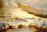
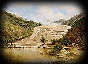
The Pink and White Terraces were two separate terraces, beside Lake Rotomahana
, 800 metres apart in a NNW direction.
The White Terraces were at the north end of Lake Rotomahana and faced away from the lake at the entrance to the kaiwaka stream. They descended to the lake edge 40 metres below, which was 280 metres above sea level. The extra sunlight they received from facing north gave them a more bleached or white appearance.
The Pink Terraces were positioned about two thirds of the way down the lake sheltered from the harsh sun on the western shores, facing south-east. Their pink appearance (near the colour of a rainbow trout
) was largely due to less sunlight reaching them and therefore less bleaching.
The foundations for both terraces were formed from alternate layers of previous volcanic fallout over a long period of time. The volcanic debris layers, alternating between rhyolitic
and sedimentary stone, formed the base for precipitation of silica.
The precipitation sloped down towards the top of the geyser and formed many pools and steps over time. Precipitation occurred in two methods. The ascending foundation over time formed a lip which would trap the descending flow and become level again. Over time this process formed attractive swimming places, both for the shape and for the warm water.. When the thermal layers sloped in the other direction away from the geyser, then silica steps formed on the surface. Both types of formation grew as silica-laden water cascaded over them, and the water also enhanced the spectacle. This process as studied in 1860 took an estimated 1000 years or more to form to the presentation as see in the accompanying photo.
The White Terraces were the larger formation, covering 3 hectares and descending over approximately 50 layers and a drop in height of 40 metres. The Pink Terraces descended 30 metres over a distance of 75 metres. The converging Pink Terraces started at the top with a width of 75-100 metres and the bottom layers were approximately 27 metres wide. The Pink Terraces were where people preferred to bathe due to the more suitable pools..
 The terraces, on the edges of Lake Rotomahana
approximately 20km southeast of Rotorua
, were New Zealand's most famous tourist attraction. The terraces started attracting tourists from all over the world from their recognition by early traders and missionaries in the 1840s. New Zealand was still relatively inaccessible and passage took several months by ship, followed by a tedious trip 150 kilometres inland to Lake Rotomahana.
. Dieffenbach and his assistant Symonds travelled from New Plymouth
via Mount Egmont (Taranaki) and Ruapehu and then around the shores of Lake Taupo
. They then travelled north, partly following the Waikato River
then east towards Maunga Kakaramea (Rainbow Mountain), reaching Rotomahana Lake late one evening. They camped overnight at the mouth of the Haumi Stream.
Dieffenbach left geological notes that gave clues as to why the lake levels varied. Because there were Pohutakawa trees around the lake, he speculated that the sea level had been much higher at some stage. It is more likely that the trees grew taller faster than the volcanic fallout accumulated. It has been observed that this species of tree has adapted to the changing environment over a long period of time.
He inspired wider interest in the Pink and White Terraces with his publications. When he had completed his short stay at Rotomahana, they continued north via Lake Tarawera
and Te Ngae to Rotorua
. Dieffenbach was employed by the New Zealand Shipping Company, his primary employer, for this excursion, and also traveled extensively throughout the North Island, making notes on flora and fauna, which can be seen in his biography at the Alexandra Turnbull Library.
When Dieffenbach completed his employment by the New Zealand Shipping Company he was forced to leave the country. His studies in the North Island were completed after he left New Zealand. When he attempted to re-enter New Zealand to continue his studies in the South Island he was refused entry.
Te Wairoa became the starting point for tourists wishing to cross Lake Tarawera to the Rotomahana tourist attractions via canoe.
This map, although not favoured by early scholars, has proven to be more accurate than several later attempts, although, as with other maps of the lake, the height above sea level was significantly incorrect in many locations. The relevant heights between lake levels and mountain peaks were in proportion, but varied as distance between reference points increased. Hochstetter was aware of this problem with using an aneroid device, and he advised several times in his original book Geology of New Zealand that the heights above sea level that he quoted were only as far he could measure due to variation in barometric preasures.
Hochstetter's studies and reports on terrace structuring in the Waipa and Rotorua areas reveal how the Terraces were formed, and he also made comments on the commercial possibilities of Rotomahana.
Being on the top of Maunga Makatiti on the night of the eruption, he had the best view of the eruption and sequence of eruption events. Warbrick was actively involved in rescuing many people affected by the eruption.
Warbrick later challenged Stephenson Percy Smith's declaration that the Pink and White terraces had been destroyed: and he held this view till his dying day.
Alfred Warbrick spent 45 years exploring and serving as a government guide in what was then referred to as the Wai-a-riki ("small water") country, never giving up on the hope that someone would listen to him, and encourage the Government of the day to uncover the Terraces and reinstate this eighth wonder of the world. He did manage to have a investigation authorised by the government. The investigation was carried out by Percy Smith who without proper justification again dismissed Warbrick's claim.
in the same area. In contrast, Stephenson Percy Smith gave the impression that the mountain top was rough but showed no sign of volcanic vents in 1873 when he reported on his findings.
.
Later revelations were to prove that both were correct although Clayton's report showed that Smith had not investigated the top of Wahanga to the same degree as Clayton. It is known that there were caves on the south west edge of Wahanga and that the symmetry of the Wahanga peak was upset by the 1886 rift.
erupted. The eruption spread from west of Wahanga Peak, five kilometres to the north, down to Lake Rotomahana. The volcano belched out hot mud, red hot boulders and immense clouds of black ash from a 17-kilometre rift that crossed the mountain, passed through the lake, and extended beyond into the Waimangu valley
. The eruption also buried several villages including the Māori and European settlement of Te Wairoa
, killing approximately 120 people.
After the eruption, a crater over 100 metres deep encompassed the former site of the terraces. After some years this filled with water to form a new Lake Rotomahana
, 30 metres higher and much larger than the old lake, due to volcanic debris blocking its outflow to Lake Tarawera
.
, Woods Hole Oceanographic Institution
, Lamont-Doherty Earth Observatory
, and Waikato University were mapping the lake floor when they discovered a portion of the Pink Terraces in February 2011. The lowest two tiers of the terraces were found in their original place at 60 metres (196.9 ft) deep (too deep for safe scuba diving
unless heliox
is used). A part of the White Terraces was rediscovered in June 2011. The announcement of the rediscovery of the White Terraces coincided with the 125th Anniversary of the eruption of Mt Tarawera in 1886. It is thought that the rest of the terraces may be buried in sediment rather than having been destroyed.
New Zealand
New Zealand is an island country in the south-western Pacific Ocean comprising two main landmasses and numerous smaller islands. The country is situated some east of Australia across the Tasman Sea, and roughly south of the Pacific island nations of New Caledonia, Fiji, and Tonga...
. They were thought to have been completely destroyed by a violent volcanic eruption in 1886.
Silicic acid
Silicic acid is a general name for a family of chemical compounds of the element silicon, hydrogen, and oxygen, with the general formula [SiOx4-2x]n...
and sodium chloride
Sodium chloride
Sodium chloride, also known as salt, common salt, table salt or halite, is an inorganic compound with the formula NaCl. Sodium chloride is the salt most responsible for the salinity of the ocean and of the extracellular fluid of many multicellular organisms...
regularly spouting from the two large above mentioned geysers. These two geysers were part of a group of 40 smaller geysers in the nearby area.
The Pink and White Terraces were two separate terraces, beside Lake Rotomahana
Lake Rotomahana
Lake Rotomahana is an lake in northern New Zealand, located 25 kilometres to the east of Rotorua. It is immediately southwest of the dormant volcano Mount Tarawera, and its geography was substantially altered by a major 1886 eruption of Mount Tarawera...
, 800 metres apart in a NNW direction.
The White Terraces were at the north end of Lake Rotomahana and faced away from the lake at the entrance to the kaiwaka stream. They descended to the lake edge 40 metres below, which was 280 metres above sea level. The extra sunlight they received from facing north gave them a more bleached or white appearance.
The Pink Terraces were positioned about two thirds of the way down the lake sheltered from the harsh sun on the western shores, facing south-east. Their pink appearance (near the colour of a rainbow trout
Rainbow trout
The rainbow trout is a species of salmonid native to tributaries of the Pacific Ocean in Asia and North America. The steelhead is a sea run rainbow trout usually returning to freshwater to spawn after 2 to 3 years at sea. In other words, rainbow trout and steelhead trout are the same species....
) was largely due to less sunlight reaching them and therefore less bleaching.
The foundations for both terraces were formed from alternate layers of previous volcanic fallout over a long period of time. The volcanic debris layers, alternating between rhyolitic
Rhyolite
This page is about a volcanic rock. For the ghost town see Rhyolite, Nevada, and for the satellite system, see Rhyolite/Aquacade.Rhyolite is an igneous, volcanic rock, of felsic composition . It may have any texture from glassy to aphanitic to porphyritic...
and sedimentary stone, formed the base for precipitation of silica.
The precipitation sloped down towards the top of the geyser and formed many pools and steps over time. Precipitation occurred in two methods. The ascending foundation over time formed a lip which would trap the descending flow and become level again. Over time this process formed attractive swimming places, both for the shape and for the warm water.. When the thermal layers sloped in the other direction away from the geyser, then silica steps formed on the surface. Both types of formation grew as silica-laden water cascaded over them, and the water also enhanced the spectacle. This process as studied in 1860 took an estimated 1000 years or more to form to the presentation as see in the accompanying photo.
The White Terraces were the larger formation, covering 3 hectares and descending over approximately 50 layers and a drop in height of 40 metres. The Pink Terraces descended 30 metres over a distance of 75 metres. The converging Pink Terraces started at the top with a width of 75-100 metres and the bottom layers were approximately 27 metres wide. The Pink Terraces were where people preferred to bathe due to the more suitable pools..
Lake Rotomahana
Lake Rotomahana is an lake in northern New Zealand, located 25 kilometres to the east of Rotorua. It is immediately southwest of the dormant volcano Mount Tarawera, and its geography was substantially altered by a major 1886 eruption of Mount Tarawera...
approximately 20km southeast of Rotorua
Rotorua
Rotorua is a city on the southern shores of the lake of the same name, in the Bay of Plenty region of the North Island of New Zealand. The city is the seat of the Rotorua District, a territorial authority encompassing the city and several other nearby towns...
, were New Zealand's most famous tourist attraction. The terraces started attracting tourists from all over the world from their recognition by early traders and missionaries in the 1840s. New Zealand was still relatively inaccessible and passage took several months by ship, followed by a tedious trip 150 kilometres inland to Lake Rotomahana.
824AD
Ferdinand von Hochstetter estimated the precipitation phase of the terraces to have commenced very close to 1036 years before his visit in 1860. His calculations were based on precipitation rates measured on site at this time against stable flow rates. He mentions reference to comparisons with The Great Geyser.in Iceland.1839-1841
One of the first Europeans to visit the Rotomahana area was Johan Karl Ernst Dieffenbach. He visited Rotomahana and the Terraces while on a mission for the New Zealand Shipping CompanyNew Zealand Shipping Company
The New Zealand Shipping Company was a shipping company whose ships ran passenger and cargo services between Great Britain and New Zealand between 1873 and 1973.-New Zealand Shipping Company:...
. Dieffenbach and his assistant Symonds travelled from New Plymouth
New Plymouth
New Plymouth is the major city of the Taranaki Region on the west coast of the North Island of New Zealand. It is named after Plymouth, Devon, England, from where the first English settlers migrated....
via Mount Egmont (Taranaki) and Ruapehu and then around the shores of Lake Taupo
Lake Taupo
Lake Taupo is a lake situated in the North Island of New Zealand. With a surface area of , it is the largest lake by surface area in New Zealand, and the second largest freshwater lake by surface area in geopolitical Oceania after Lake Murray ....
. They then travelled north, partly following the Waikato River
Waikato River
The Waikato River is the longest river in New Zealand. In the North Island, it runs for 425 kilometres from the eastern slopes of Mount Ruapehu, joining the Tongariro River system and emptying into Lake Taupo, New Zealand's largest lake. It drains Taupo at the lake's northeastern edge, creates the...
then east towards Maunga Kakaramea (Rainbow Mountain), reaching Rotomahana Lake late one evening. They camped overnight at the mouth of the Haumi Stream.
Dieffenbach left geological notes that gave clues as to why the lake levels varied. Because there were Pohutakawa trees around the lake, he speculated that the sea level had been much higher at some stage. It is more likely that the trees grew taller faster than the volcanic fallout accumulated. It has been observed that this species of tree has adapted to the changing environment over a long period of time.
He inspired wider interest in the Pink and White Terraces with his publications. When he had completed his short stay at Rotomahana, they continued north via Lake Tarawera
Lake Tarawera
Lake Tarawera is the largest of a series of lakes which surround the volcano Mount Tarawera in the North Island of New Zealand. Like the mountain, it lies within the Okataina caldera. It is located 18 kilometres to the east of Rotorua, and five kilometres to the west of the mountain...
and Te Ngae to Rotorua
Rotorua
Rotorua is a city on the southern shores of the lake of the same name, in the Bay of Plenty region of the North Island of New Zealand. The city is the seat of the Rotorua District, a territorial authority encompassing the city and several other nearby towns...
. Dieffenbach was employed by the New Zealand Shipping Company, his primary employer, for this excursion, and also traveled extensively throughout the North Island, making notes on flora and fauna, which can be seen in his biography at the Alexandra Turnbull Library.
When Dieffenbach completed his employment by the New Zealand Shipping Company he was forced to leave the country. His studies in the North Island were completed after he left New Zealand. When he attempted to re-enter New Zealand to continue his studies in the South Island he was refused entry.
1845-1870
The Reverend Seymour Mills Spencer and his wife Ellen followed an ambition to carry out the role of missionary work in New Zealand. They were American and trained for missionary work in England. Spencer was posted to New Zealand to work under the missionary Thomas Chapman at the recently formed Te Ngae branch of the Church of England Mission. He was to take over the newly formed Taupo branch but due to scandal over Spencer's purported advances toward a Māori girl, the couple moved to Lake Tarawera. There they formed the first missionary post at Lake Tarawera; working with the local Māori they built a European-styled community called Te Wairoa. Spencer visited Rotomahana and Te Ariki many times during his 35 year term there. His work with the local Māori helped develop the area, and he was also instrumental in assisting explorers and traders in the vicinity. Seymour was reinstated to the church in 1850.Te Wairoa became the starting point for tourists wishing to cross Lake Tarawera to the Rotomahana tourist attractions via canoe.
28-30 April 1859
Ferdinand von Hochstetter carried out a geographic and geological survey of Rotomahana Lake and area at the request of the New Zealand Government. His Geographic and Geological survey was prepared in just three days on the lake but gave enough data to form the first map of the area.This map, although not favoured by early scholars, has proven to be more accurate than several later attempts, although, as with other maps of the lake, the height above sea level was significantly incorrect in many locations. The relevant heights between lake levels and mountain peaks were in proportion, but varied as distance between reference points increased. Hochstetter was aware of this problem with using an aneroid device, and he advised several times in his original book Geology of New Zealand that the heights above sea level that he quoted were only as far he could measure due to variation in barometric preasures.
Hochstetter's studies and reports on terrace structuring in the Waipa and Rotorua areas reveal how the Terraces were formed, and he also made comments on the commercial possibilities of Rotomahana.
24 February 1860
Alfred Patchet Warbrick was born near the lower pools of The White Terraces. His father, Abraham Warbick, a trader from Tauranga, had married Nga-Karauma, a Māori chief's daughter. Warbrick had been associated with the Pink and White Terraces from an early age, assisting Kate Middlemass who guided tourists and gave him his first bath in the lower White Terrace pools. He became a skilled boat builder and was involved in whale boat building before and after the 10 June 1886 eruption.Being on the top of Maunga Makatiti on the night of the eruption, he had the best view of the eruption and sequence of eruption events. Warbrick was actively involved in rescuing many people affected by the eruption.
Warbrick later challenged Stephenson Percy Smith's declaration that the Pink and White terraces had been destroyed: and he held this view till his dying day.
Alfred Warbrick spent 45 years exploring and serving as a government guide in what was then referred to as the Wai-a-riki ("small water") country, never giving up on the hope that someone would listen to him, and encourage the Government of the day to uncover the Terraces and reinstate this eighth wonder of the world. He did manage to have a investigation authorised by the government. The investigation was carried out by Percy Smith who without proper justification again dismissed Warbrick's claim.
1872-1873
Stephenson Percy Smith was involved in a pre eruption survey of Mount Tarawera which was never finalised.March 1881
Dr. G. Seelhorst climbed Wahanga dome and the northern end of Ruawhai dome in search of a presumed falling star followed by reports of glowing and smoke from an area behind Wahanga. This ties in with reports of the first explosion at about 2:15 in the morning of the 10th June 1886, and lends credibility to the claim that Wahanga erupted first as suggested by Albert Warbrick.1880 to 1886
Sophia Hinerangi, sometimes known as Te Paea (Tepaea), became recognised as the principal tourist guide of the Pink and White Terraces and guided the tourists in the whaling boats from Te Wairoa to Te Ariki near Lake Rotomahana. Sophia took over as principal guide from the older Kate Middlemass in the early 1880s. Both guides are well documented for their involvement in guiding tourists to the Terraces. Kate Middlemass was instrumental in guiding Seelhorst to the alleged fallen star.Sophia Hinerangi was also the last guide to take tourists to the Terraces before the eruption. Sophia observed the pre eruption violence in the thermal wonderland and the disturbances to lake tarawera water levels days before the eruption.1884
In 1884 a surveyor named Charles Clayton was surveying for work in the Kawerau area and described the top of Wahanga dome as volcanic with several depressions, one being approximately 200 feet deep. This is proven true by recent semifluid magma flows consolidating on top of older scoriaScoria
Scoria is a volcanic rock containing many holes or vesicles. It is most generally dark in color , and basaltic or andesitic in composition. Scoria is relatively low in mass as a result of its numerous macroscopic ellipsoidal vesicles, but in contrast to pumice, all scoria has a specific gravity...
in the same area. In contrast, Stephenson Percy Smith gave the impression that the mountain top was rough but showed no sign of volcanic vents in 1873 when he reported on his findings.
.
Later revelations were to prove that both were correct although Clayton's report showed that Smith had not investigated the top of Wahanga to the same degree as Clayton. It is known that there were caves on the south west edge of Wahanga and that the symmetry of the Wahanga peak was upset by the 1886 rift.
The eruption
On 9-10 June 1886 Mount TaraweraMount Tarawera
Mount Tarawera is the volcano responsible for New Zealand's largest historic eruption. Located 24 kilometres southeast of Rotorua in the North Island, it consists of a series of rhyolitic lava domes that were fissured down the middle by an explosive basaltic eruption in 1886, which killed over...
erupted. The eruption spread from west of Wahanga Peak, five kilometres to the north, down to Lake Rotomahana. The volcano belched out hot mud, red hot boulders and immense clouds of black ash from a 17-kilometre rift that crossed the mountain, passed through the lake, and extended beyond into the Waimangu valley
Waimangu Volcanic Rift Valley
Waimangu Volcanic Rift Valley is the hydrothermal system created on 10 June 1886 by the volcanic eruption of Mount Tarawera, on the North Island of New Zealand. It encompasses Lake Rotomahana, the former site of the Pink and White Terraces. It was the location of the Waimangu Geyser, which was...
. The eruption also buried several villages including the Māori and European settlement of Te Wairoa
Te Wairoa
Te Wairoa, also known as The Buried Village is located close to the shore of Lake Tarawera in New Zealand's North Island. It was a Māori and European settlement where visitors would stay on their way to visit the Pink and White Terraces. The village was destroyed by the eruption of the volcano...
, killing approximately 120 people.
After the eruption, a crater over 100 metres deep encompassed the former site of the terraces. After some years this filled with water to form a new Lake Rotomahana
Lake Rotomahana
Lake Rotomahana is an lake in northern New Zealand, located 25 kilometres to the east of Rotorua. It is immediately southwest of the dormant volcano Mount Tarawera, and its geography was substantially altered by a major 1886 eruption of Mount Tarawera...
, 30 metres higher and much larger than the old lake, due to volcanic debris blocking its outflow to Lake Tarawera
Lake Tarawera
Lake Tarawera is the largest of a series of lakes which surround the volcano Mount Tarawera in the North Island of New Zealand. Like the mountain, it lies within the Okataina caldera. It is located 18 kilometres to the east of Rotorua, and five kilometres to the west of the mountain...
.
Rediscovery
The terraces were long thought to have been destroyed around 3 a.m. on 10 June 1886 during the eruption. However, a team including researchers from GNS ScienceGNS Science
GNS Science is a New Zealand Crown Research Institute. It focuses on geology, geophysics , and nuclear science ....
, Woods Hole Oceanographic Institution
Woods Hole Oceanographic Institution
The Woods Hole Oceanographic Institution is a private, nonprofit research and higher education facility dedicated to the study of all aspects of marine science and engineering and to the education of marine researchers. Established in 1930, it is the largest independent oceanographic research...
, Lamont-Doherty Earth Observatory
Lamont-Doherty Earth Observatory
The Lamont–Doherty Earth Observatory is a research unit of Columbia University located on a campus in Palisades, N.Y., north of Manhattan on the Hudson River.- History :...
, and Waikato University were mapping the lake floor when they discovered a portion of the Pink Terraces in February 2011. The lowest two tiers of the terraces were found in their original place at 60 metres (196.9 ft) deep (too deep for safe scuba diving
Scuba diving
Scuba diving is a form of underwater diving in which a diver uses a scuba set to breathe underwater....
unless heliox
Heliox
Heliox is a breathing gas composed of a mixture of helium and oxygen .Heliox has been used medically since the 1930s, and although the medical community adopted it initially to alleviate symptoms of upper airway obstruction, its range of medical uses has since expanded greatly, mostly because of...
is used). A part of the White Terraces was rediscovered in June 2011. The announcement of the rediscovery of the White Terraces coincided with the 125th Anniversary of the eruption of Mt Tarawera in 1886. It is thought that the rest of the terraces may be buried in sediment rather than having been destroyed.
Similar places
- Badab-e SurtBadab-e SurtBadab-e Surt is a natural site in Mazandaran Province in northern Iran, located 68 kilometers north of city of Damghan, 95 kilometers South of city of Sari, and 7 kilometers west of Orost village...
in Iran - Geothermal areas of YellowstoneGeothermal areas of YellowstoneThe geothermal areas of Yellowstone include several geyser basins in Yellowstone National Park as well as other geothermal features such as hot springs, mud pots, and fumaroles...
in the United States - PamukkalePamukkalePamukkale, meaning "cotton castle" in Turkish, is a natural site in Denizli Province in southwestern Turkey. The city contains hot springs and travertines, terraces of carbonate minerals left by the flowing water...
in Turkey - SaturniaSaturniaSaturnia is a spa town in Tuscany in north-central Italy that has been inhabited since ancient times. It is a frazione of the comune of Manciano, in the province of Grosseto. Famous for the homonym spa, its population is of 280.- Geography :...
in Italy