
Lahar
Encyclopedia
A lahar (ˈlɑːhɑr) is a type of mudflow
or debris flow
composed of a slurry
of pyroclastic material, rocky debris, and water
. The material flows down from a volcano
, typically along a river
valley
. The term is a shortened version of "berlahar" which originated in the Javanese language
of Indonesia
.
n word that describes volcanic mudflows or debris flows. Lahars have the consistency, viscosity and approximately the same density of concrete
: fluid when moving, then solid when stopped. Lahars can be huge: the Osceola lahar produced 5,600 years ago by Mount Rainier
in Washington produced a wall of mud 140 metres (459.3 ft) deep in the White River
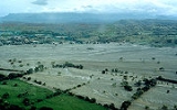
canyon and covered an area of over 330 square kilometres (127.4 sq mi) for a total volume of 2.3 cubic kilometre (0.551799344789859 cu mi), and can bulldoze through virtually any structure in its path. A lahar is capable of carving its own pathway, making the prediction of its course difficult. A Lahar quickly loses force when it leaves the channel of its flow: even frail huts may remain standing while being buried up to the roof with mud. The viscosity of a lahar decreases with time and amount of rain, although the mud solidifies quickly when it stops moving.
Lahar flows can be deadly because of their energy and speed. They can flow up to approximately 100 kilometres per hour (62.1 mph), can flow for more than 300 kilometres (186.4 mi), and can cause catastrophic destruction in their path. The lahars from the Nevado del Ruiz
eruption in Colombia
in 1985 caused the Armero tragedy, which killed an estimated 23,000 when the city of Armero
was buried under 5 metres (16 ft) of mud and debris. New Zealand
's Tangiwai disaster
in 1953, where 151 people died after a Christmas Eve express train fell into the Whangaehu River
, was caused by a lahar. Lahars have been responsible for 17% of volcano-related deaths between 1783 and 1997. Lahars can cause fatalities years after an actual eruption: for example, the Cabalantian tragedy
four years after the 1991 eruption of Mount Pinatubo
.
In particular, although lahars are typically associated with the effects of volcanic activity, lahars can occur even without any current volcanic activity, as long as the conditions are right to cause the collapse and movement of mud originating from existing volcanic ash
deposits.
 Several mountains in the world, including Mount Rainier
in the US
, Mount Ruapehu
in New Zealand
, and Galunggung
in Indonesia
, are considered particularly dangerous due to the risk of lahars. Several towns in the Puyallup River
valley in Washington state, including Orting
, are built on top of lahar deposits that are only about 500 years old. Lahars are predicted to flow through the valley every 500-1,000 years, so Orting, Sumner
, Puyallup
, Fife
, and the Port of Tacoma
face considerable risk.
The USGS has set up lahar warning sirens
in Pierce County
, so that people can flee an approaching debris flow.
A lahar warning system
has been set up at Mount Ruapehu by the New Zealand Department of Conservation
and hailed as a success after it successfully alerted officials to an impending lahar on 18 March 2007.
Since mid-June 1991, when violent eruptions triggered Mount Pinatubo
's first lahars in 500 years, a system to monitor and warn of lahars has been in operation. Radio-telemetered rain gauges provide data on rainfall in lahar source regions, acoustic flow monitors on stream banks detect ground vibration as lahars pass, and manned watchpoints further confirm that lahars are rushing down Pinatubo's slopes. This system has enabled warnings to be sounded for most but not all major lahars at Pinatubo, saving hundreds of lives. Physical preventative measures by the Philippine government were not adequate to stop over 20 feet (6.1 m) of mud from flooding many villages around Mount Pinatubo from 1992 through 1998.
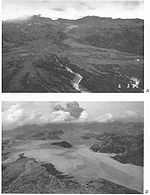
 In 1985, the volcano Nevado del Ruiz
erupted. As pyroclastic flows erupted from the volcano's crater
, they melted the mountain's glaciers, sending four enormous lahars down its slopes at 60 kilometres per hour (37.3 mph). The lahars picked up speed in gullies
and coursed into the six major rivers at the base of the volcano; they engulfed the town of Armero
, killing more than 20,000 of its almost 29,000 inhabitants. Casualties in other towns, particularly Chinchiná, brought the overall death toll to 23,000. Footage and photographs of Omayra Sánchez
, a young victim of the tragedy
, were published around the world. Other photographs of the lahars and the impact of the disaster captured attention worldwide and led to controversy over the degree to which the Colombian government was responsible for the disaster. A banner at a mass funeral in Ibague read, "The volcano didn't kill 22,000 people. The government killed them."
 The 1991 eruption of Mount Pinatubo
caused lahar flows: the first eruption itself killed only six people, but the lahar flows killed more than 1500. The eye of Typhoon Yunya passed over the volcano during its eruption on June 15, 1991. The rain from the typhoon triggered the flow of volcanic ash
, boulders, and water down the rivers surrounding the volcano
. Angeles City was damaged by the volcano's sticky mud when Sapang Balen Creek and the Abacan River became the channel for the lahar and carried it to the heart of the city. Over 20 feet (6 m) of mud destroyed or damaged Castillejos
, San Marcelino
, Botolan
, Porac
, Mabalacat
, Tarlac City, Capas
, Concepcion
, and Bamban
. The mud flow down the Sacobia Bamban River scoured all structures in its path, including the bridges and dikes by the Parua river in Concepcion
. The Tarlac River
in Tarlac City was inundated by over 20 feet (6 m) of lahar, causing the river to lose the ability to hold water.
On the morning of October 1, 1995, pyroclastic material which clung to the slopes of Pinatubo and surrounding mountains rushed down because of heavy rain, and turned into a 25 feet (8 m) lahar. The mudflow killed hundreds of people in Barangay Cabalantian in Bacolor
. The Philippine government under former president Fidel V. Ramos
ordered the construction of the FVR Mega Dike in an attempt to protect people from further mudflows.
Mudflow
A mudslide is the most rapid and fluid type of downhill mass wasting. It is a rapid movement of a large mass of mud formed from loose soil and water. Similar terms are mudflow, mud stream, debris flow A mudslide is the most rapid (up to 80 km/h, or 50 mph) and fluid type of downhill mass...
or debris flow
Debris flow
A debris flow is a fast moving, liquefied landslide of unconsolidated, saturated debris that looks like flowing concrete. It is differentiated from a mudflow in terms of the viscosity and textural properties of the flow. Flows can carry material ranging in size from clay to boulders, and may...
composed of a slurry
Slurry
A slurry is, in general, a thick suspension of solids in a liquid.-Examples of slurries:Examples of slurries include:* Lahars* A mixture of water and cement to form concrete* A mixture of water, gelling agent, and oxidizers used as an explosive...
of pyroclastic material, rocky debris, and water
Water
Water is a chemical substance with the chemical formula H2O. A water molecule contains one oxygen and two hydrogen atoms connected by covalent bonds. Water is a liquid at ambient conditions, but it often co-exists on Earth with its solid state, ice, and gaseous state . Water also exists in a...
. The material flows down from a volcano
Volcano
2. Bedrock3. Conduit 4. Base5. Sill6. Dike7. Layers of ash emitted by the volcano8. Flank| 9. Layers of lava emitted by the volcano10. Throat11. Parasitic cone12. Lava flow13. Vent14. Crater15...
, typically along a river
River
A river is a natural watercourse, usually freshwater, flowing towards an ocean, a lake, a sea, or another river. In a few cases, a river simply flows into the ground or dries up completely before reaching another body of water. Small rivers may also be called by several other names, including...
valley
Valley
In geology, a valley or dale is a depression with predominant extent in one direction. A very deep river valley may be called a canyon or gorge.The terms U-shaped and V-shaped are descriptive terms of geography to characterize the form of valleys...
. The term is a shortened version of "berlahar" which originated in the Javanese language
Javanese language
Javanese language is the language of the Javanese people from the central and eastern parts of the island of Java, in Indonesia. In addition, there are also some pockets of Javanese speakers in the northern coast of western Java...
of Indonesia
Indonesia
Indonesia , officially the Republic of Indonesia , is a country in Southeast Asia and Oceania. Indonesia is an archipelago comprising approximately 13,000 islands. It has 33 provinces with over 238 million people, and is the world's fourth most populous country. Indonesia is a republic, with an...
.
Description
"Lahar" is an IndonesiaIndonesia
Indonesia , officially the Republic of Indonesia , is a country in Southeast Asia and Oceania. Indonesia is an archipelago comprising approximately 13,000 islands. It has 33 provinces with over 238 million people, and is the world's fourth most populous country. Indonesia is a republic, with an...
n word that describes volcanic mudflows or debris flows. Lahars have the consistency, viscosity and approximately the same density of concrete
Concrete
Concrete is a composite construction material, composed of cement and other cementitious materials such as fly ash and slag cement, aggregate , water and chemical admixtures.The word concrete comes from the Latin word...
: fluid when moving, then solid when stopped. Lahars can be huge: the Osceola lahar produced 5,600 years ago by Mount Rainier
Mount Rainier
Mount Rainier is a massive stratovolcano located southeast of Seattle in the state of Washington, United States. It is the most topographically prominent mountain in the contiguous United States and the Cascade Volcanic Arc, with a summit elevation of . Mt. Rainier is considered one of the most...
in Washington produced a wall of mud 140 metres (459.3 ft) deep in the White River
White River (Washington)
The White River is a white, glacial river in the U.S. state of Washington. It flows about 75 miles from its source, the Emmons Glacier on Mount Rainier, to join the Puyallup River at Sumner...
canyon and covered an area of over 330 square kilometres (127.4 sq mi) for a total volume of 2.3 cubic kilometre (0.551799344789859 cu mi), and can bulldoze through virtually any structure in its path. A lahar is capable of carving its own pathway, making the prediction of its course difficult. A Lahar quickly loses force when it leaves the channel of its flow: even frail huts may remain standing while being buried up to the roof with mud. The viscosity of a lahar decreases with time and amount of rain, although the mud solidifies quickly when it stops moving.
Lahar flows can be deadly because of their energy and speed. They can flow up to approximately 100 kilometres per hour (62.1 mph), can flow for more than 300 kilometres (186.4 mi), and can cause catastrophic destruction in their path. The lahars from the Nevado del Ruiz
Nevado del Ruiz
The Nevado del Ruiz, also known as La Mesa de Herveo or Kumanday in the language of the local pre-Columbian indigenous people, is a volcano located on the border of the departments of Caldas and Tolima in Colombia, about west of the capital city Bogotá. It is a stratovolcano, composed of many...
eruption in Colombia
Colombia
Colombia, officially the Republic of Colombia , is a unitary constitutional republic comprising thirty-two departments. The country is located in northwestern South America, bordered to the east by Venezuela and Brazil; to the south by Ecuador and Peru; to the north by the Caribbean Sea; to the...
in 1985 caused the Armero tragedy, which killed an estimated 23,000 when the city of Armero
Armero
The Armero tragedy was one of the major consequences of the eruption of the Nevado del Ruiz stratovolcano in Tolima, Colombia on November 13, 1985...
was buried under 5 metres (16 ft) of mud and debris. New Zealand
New Zealand
New Zealand is an island country in the south-western Pacific Ocean comprising two main landmasses and numerous smaller islands. The country is situated some east of Australia across the Tasman Sea, and roughly south of the Pacific island nations of New Caledonia, Fiji, and Tonga...
's Tangiwai disaster
Tangiwai disaster
The Tangiwai disaster on 24 December 1953 was the worst rail accident in New Zealand history. An 11-carriage overnight express from Wellington to Auckland fell into the Whangaehu River at Tangiwai, ten kilometres west of Waiouru. The bridge carrying the North Island Main Trunk Railway over the...
in 1953, where 151 people died after a Christmas Eve express train fell into the Whangaehu River
Whangaehu River
The Whangaehu River is a large river in central North Island of New Zealand. Its headwaters are the crater lake of Mount Ruapehu on the central plateau, and it flows into the Tasman Sea eight kilometres southeast of Wanganui.-Length:...
, was caused by a lahar. Lahars have been responsible for 17% of volcano-related deaths between 1783 and 1997. Lahars can cause fatalities years after an actual eruption: for example, the Cabalantian tragedy
Bacolor, Pampanga
Bacolor is a 3rd class municipality in the province of Pampanga, Philippines.-Demographics:According to the latest census, it has a population of 25,238 people in 3,029 households.-History:...
four years after the 1991 eruption of Mount Pinatubo
Mount Pinatubo
Mount Pinatubo is an active stratovolcano located on the island of Luzon, near the tripoint of the Philippine provinces of Zambales, Tarlac, and Pampanga. It is located in the Tri-Cabusilan Mountain range separating the west coast of Luzon from the central plains, and is west of the dormant and...
.
Causes
Lahars have several possible causes:- SnowSnowSnow is a form of precipitation within the Earth's atmosphere in the form of crystalline water ice, consisting of a multitude of snowflakes that fall from clouds. Since snow is composed of small ice particles, it is a granular material. It has an open and therefore soft structure, unless packed by...
and glacierGlacierA glacier is a large persistent body of ice that forms where the accumulation of snow exceeds its ablation over many years, often centuries. At least 0.1 km² in area and 50 m thick, but often much larger, a glacier slowly deforms and flows due to stresses induced by its weight...
s can be melted by lava or pyroclastic flowPyroclastic flowA pyroclastic flow is a fast-moving current of superheated gas and rock , which reaches speeds moving away from a volcano of up to 700 km/h . The flows normally hug the ground and travel downhill, or spread laterally under gravity...
s during an eruption - A floodFloodA flood is an overflow of an expanse of water that submerges land. The EU Floods directive defines a flood as a temporary covering by water of land not normally covered by water...
caused by a glacier, lake breakoutLake breakoutLake breakout is a geological term that refers to the collapse of a lake. High-altitude lakes tend to form in volcanic craters – where they are called crater lakes – or in valleys dammed as the result of earthquakes or glacial or volcanic deposition...
, or heavy rainfall can release a lahar, also called glacier run or jökulhlaupJökulhlaupA jökulhlaup is a glacial outburst flood. It is an Icelandic term that has been adopted by the English language. It originally referred to the well-known subglacial outburst floods from Vatnajökull, Iceland which are triggered by geothermal heating and occasionally by a volcanic subglacial... - Water from a crater lake, combined with volcanic material in an eruption
In particular, although lahars are typically associated with the effects of volcanic activity, lahars can occur even without any current volcanic activity, as long as the conditions are right to cause the collapse and movement of mud originating from existing volcanic ash
Volcanic ash
Volcanic ash consists of small tephra, which are bits of pulverized rock and glass created by volcanic eruptions, less than in diameter. There are three mechanisms of volcanic ash formation: gas release under decompression causing magmatic eruptions; thermal contraction from chilling on contact...
deposits.
- Snow and glaciers can melt during periods of mild weather
- Earthquakes underneath or close to the volcano can shake material loose and cause it to collapse triggering a lahar avalanche.
- Rainfall or typhoons can cause the still-hanging slabs of solidified mud to come rushing down the slopes at a speed of more than 30 Kilometers per hour, causing devastating results.
Places at risk
Mount Rainier
Mount Rainier is a massive stratovolcano located southeast of Seattle in the state of Washington, United States. It is the most topographically prominent mountain in the contiguous United States and the Cascade Volcanic Arc, with a summit elevation of . Mt. Rainier is considered one of the most...
in the US
United States
The United States of America is a federal constitutional republic comprising fifty states and a federal district...
, Mount Ruapehu
Mount Ruapehu
Mount Ruapehu, or just Ruapehu, is an active stratovolcano at the southern end of the Taupo Volcanic Zone in New Zealand. It is 23 kilometres northeast of Ohakune and 40 kilometres southwest of the southern shore of Lake Taupo, within Tongariro National Park...
in New Zealand
New Zealand
New Zealand is an island country in the south-western Pacific Ocean comprising two main landmasses and numerous smaller islands. The country is situated some east of Australia across the Tasman Sea, and roughly south of the Pacific island nations of New Caledonia, Fiji, and Tonga...
, and Galunggung
Galunggung
Mount Galunggung is an active stratovolcano in West Java, Indonesia, around 80 km southeast of the West Java provincial capital, Bandung...
in Indonesia
Indonesia
Indonesia , officially the Republic of Indonesia , is a country in Southeast Asia and Oceania. Indonesia is an archipelago comprising approximately 13,000 islands. It has 33 provinces with over 238 million people, and is the world's fourth most populous country. Indonesia is a republic, with an...
, are considered particularly dangerous due to the risk of lahars. Several towns in the Puyallup River
Puyallup River
The Puyallup River is a river in the U.S. state of Washington. About long, it is formed by glaciers on the west side of Mount Rainier. It flows generally northwest, emptying into Commencement Bay, part of Puget Sound...
valley in Washington state, including Orting
Orting, Washington
Orting is a city in Pierce County, Washington, United States. The population as of the 2010 census is 6,746, according to the City of Orting.- History :...
, are built on top of lahar deposits that are only about 500 years old. Lahars are predicted to flow through the valley every 500-1,000 years, so Orting, Sumner
Sumner, Washington
Sumner is a city in northern Pierce County, Washington, United States. The population was 9,451 at the 2010 census. Nearby cities include Puyallup to the west, Auburn to the north, and Enumclaw to the east.-History:...
, Puyallup
Puyallup, Washington
Puyallup, Washington is a city in Pierce County, Washington about five miles east of Tacoma. The population was 37,022 at the 2010 Census. Named after the Puyallup Tribe of Native Americans, Puyallup means "the generous people."-History:...
, Fife
Fife, Washington
Fife is a city in Pierce County, Washington, United States. The population was 9,173 at the 2010 census.-History:In 1940, it was described as "Fife...at a valley crossroads in the midst of a thickly settled berry growing and truck-gardening district is represented by a string of markets, taverns,...
, and the Port of Tacoma
Tacoma, Washington
Tacoma is a mid-sized urban port city and the county seat of Pierce County, Washington, United States. The city is on Washington's Puget Sound, southwest of Seattle, northeast of the state capital, Olympia, and northwest of Mount Rainier National Park. The population was 198,397, according to...
face considerable risk.
The USGS has set up lahar warning sirens
Mount Rainier Volcano Lahar Warning System
The Mount Rainier Volcano Lahar Warning System is a loose-knit, emergency notification and warning system developed by the United States Geological Survey in 1998, and now operated by the Pierce County Department of Emergency Management and several cities...
in Pierce County
Pierce County, Washington
right|thumb|[[Tacoma, Washington|Tacoma]] - Seat of Pierce CountyPierce County is the second most populous county in the U.S. state of Washington. Formed out of Thurston County on December 22, 1852, by the legislature of Oregon Territory...
, so that people can flee an approaching debris flow.
A lahar warning system
Warning system
A warning system is any system of biological or technical nature deployed by an individual or group to inform of a future danger. Its purpose is to enable the deployer of the warning system to prepare for the danger and act accordingly to mitigate or avoid it....
has been set up at Mount Ruapehu by the New Zealand Department of Conservation
New Zealand Department of Conservation
The Department of Conservation , commonly known by its acronym, "DOC", is the state sector organisation which deals with the conservation of New Zealand’s natural and historic heritage...
and hailed as a success after it successfully alerted officials to an impending lahar on 18 March 2007.
Since mid-June 1991, when violent eruptions triggered Mount Pinatubo
Mount Pinatubo
Mount Pinatubo is an active stratovolcano located on the island of Luzon, near the tripoint of the Philippine provinces of Zambales, Tarlac, and Pampanga. It is located in the Tri-Cabusilan Mountain range separating the west coast of Luzon from the central plains, and is west of the dormant and...
's first lahars in 500 years, a system to monitor and warn of lahars has been in operation. Radio-telemetered rain gauges provide data on rainfall in lahar source regions, acoustic flow monitors on stream banks detect ground vibration as lahars pass, and manned watchpoints further confirm that lahars are rushing down Pinatubo's slopes. This system has enabled warnings to be sounded for most but not all major lahars at Pinatubo, saving hundreds of lives. Physical preventative measures by the Philippine government were not adequate to stop over 20 feet (6.1 m) of mud from flooding many villages around Mount Pinatubo from 1992 through 1998.
Nevado del Ruiz
Nevado del Ruiz
The Nevado del Ruiz, also known as La Mesa de Herveo or Kumanday in the language of the local pre-Columbian indigenous people, is a volcano located on the border of the departments of Caldas and Tolima in Colombia, about west of the capital city Bogotá. It is a stratovolcano, composed of many...
erupted. As pyroclastic flows erupted from the volcano's crater
Volcanic crater
A volcanic crater is a circular depression in the ground caused by volcanic activity. It is typically a basin, circular in form within which occurs a vent from which magma erupts as gases, lava, and ejecta. A crater can be of large dimensions, and sometimes of great depth...
, they melted the mountain's glaciers, sending four enormous lahars down its slopes at 60 kilometres per hour (37.3 mph). The lahars picked up speed in gullies
Gully
A gully is a landform created by running water, eroding sharply into soil, typically on a hillside. Gullies resemble large ditches or small valleys, but are metres to tens of metres in depth and width...
and coursed into the six major rivers at the base of the volcano; they engulfed the town of Armero
Armero
The Armero tragedy was one of the major consequences of the eruption of the Nevado del Ruiz stratovolcano in Tolima, Colombia on November 13, 1985...
, killing more than 20,000 of its almost 29,000 inhabitants. Casualties in other towns, particularly Chinchiná, brought the overall death toll to 23,000. Footage and photographs of Omayra Sánchez
Omayra Sánchez
Omaira Sánchez was a 13-year-old victim of the 1985 eruption of the Nevado del Ruiz volcano, which erupted on November 13, 1985, in Armero, Colombia causing massive lahars which killed nearly 25,000. Trapped for three days in water, concrete, and other debris before she died, Omayra captured the...
, a young victim of the tragedy
Tragedy (event)
A tragedy is an event in which one or more losses, usually of human life, occurs that is viewed as mournful. Such an event is said to be tragic....
, were published around the world. Other photographs of the lahars and the impact of the disaster captured attention worldwide and led to controversy over the degree to which the Colombian government was responsible for the disaster. A banner at a mass funeral in Ibague read, "The volcano didn't kill 22,000 people. The government killed them."
Mount Pinatubo
Mount Pinatubo
Mount Pinatubo is an active stratovolcano located on the island of Luzon, near the tripoint of the Philippine provinces of Zambales, Tarlac, and Pampanga. It is located in the Tri-Cabusilan Mountain range separating the west coast of Luzon from the central plains, and is west of the dormant and...
caused lahar flows: the first eruption itself killed only six people, but the lahar flows killed more than 1500. The eye of Typhoon Yunya passed over the volcano during its eruption on June 15, 1991. The rain from the typhoon triggered the flow of volcanic ash
Volcanic ash
Volcanic ash consists of small tephra, which are bits of pulverized rock and glass created by volcanic eruptions, less than in diameter. There are three mechanisms of volcanic ash formation: gas release under decompression causing magmatic eruptions; thermal contraction from chilling on contact...
, boulders, and water down the rivers surrounding the volcano
Volcano
2. Bedrock3. Conduit 4. Base5. Sill6. Dike7. Layers of ash emitted by the volcano8. Flank| 9. Layers of lava emitted by the volcano10. Throat11. Parasitic cone12. Lava flow13. Vent14. Crater15...
. Angeles City was damaged by the volcano's sticky mud when Sapang Balen Creek and the Abacan River became the channel for the lahar and carried it to the heart of the city. Over 20 feet (6 m) of mud destroyed or damaged Castillejos
Castillejos, Zambales
Castillejos is a municipality in the province of Zambales, Philippines. According to the latest census, it has a population of 42,910 people in 7,238 households.-Barangays:Castillejos is politically subdivided into 14 barangays.* Balaybay* Buenavista...
, San Marcelino
San Marcelino, Zambales
San Marcelino is a 1st class municipality in the province of Zambales, Philippines. According to the latest census, it has a population of 29,052 people in 5,866 households.-Etymology:...
, Botolan
Botolan, Zambales
Botolan is a 1st class municipality in the province of Zambales, Philippines. According to the latest census, it has a population of 51,675 people in 9,629 households.Botolan is the largest municipality in terms of land area in the province...
, Porac
Porac, Pampanga
Porac is a 1st class municipality in the province of Pampanga, Philippines. According to the latest census, it has a population of 102,962 people in 15,686 households.Porac is the largest town in Pampanga...
, Mabalacat
Mabalacat, Pampanga
Mabalacat is a 1st class municipality in the northern part of the province of Pampanga, Philippines. According to the latest census, it has a population of 203,307 people in 35,134 households....
, Tarlac City, Capas
Capas, Tarlac
Capas is a first class municipality in the province of Tarlac, Philippines. According to the latest census, it has a population of 122,084 people in 18,333 households. It is a part of the Third Municipal district of Tarlac with Mayor Antonio "TJ" Capitulo Rodriguez, Jr. as its incumbent Mayor and...
, Concepcion
Concepcion, Tarlac
Concepcion is a 1st class urban municipality in the province of Tarlac, Philippines. According to the latest census, it has a population of 135,213 people in 20,851 households. The 2007 Municipal Survey counted Concepcion with 133,011 of Population....
, and Bamban
Bamban, Tarlac
Bamban is a 3rd class municipality in the province of Tarlac, Philippines. According to the latest census, it has a population of 61,644 people in 9,113 households....
. The mud flow down the Sacobia Bamban River scoured all structures in its path, including the bridges and dikes by the Parua river in Concepcion
Concepcion, Tarlac
Concepcion is a 1st class urban municipality in the province of Tarlac, Philippines. According to the latest census, it has a population of 135,213 people in 20,851 households. The 2007 Municipal Survey counted Concepcion with 133,011 of Population....
. The Tarlac River
Tarlac River
The Tarlac River is a river in the Philippines, located in the province of Tarlac.It is visible from the dike near the Tarlac City Wet Market. It was formerly the site of traditional balsa or bamboo raft riding, until the river was heavily silted by sticky lahar or mud flow brought by Mt. Pinatubo...
in Tarlac City was inundated by over 20 feet (6 m) of lahar, causing the river to lose the ability to hold water.
On the morning of October 1, 1995, pyroclastic material which clung to the slopes of Pinatubo and surrounding mountains rushed down because of heavy rain, and turned into a 25 feet (8 m) lahar. The mudflow killed hundreds of people in Barangay Cabalantian in Bacolor
Bacolor, Pampanga
Bacolor is a 3rd class municipality in the province of Pampanga, Philippines.-Demographics:According to the latest census, it has a population of 25,238 people in 3,029 households.-History:...
. The Philippine government under former president Fidel V. Ramos
Fidel V. Ramos
Fidel "Eddie" Valdez Ramos , popularly known as FVR, was the 12th President of the Philippines from 1992 to 1998. During his six years in office, Ramos was widely credited and admired by many for revitalizing and renewing international confidence in the Philippine economy.Prior to his election as...
ordered the construction of the FVR Mega Dike in an attempt to protect people from further mudflows.