
Raoul Island
Encyclopedia
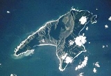
Anvil
-shaped Raoul Island (Sunday Island), the largest and northernmost of the main Kermadec Islands
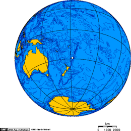
, (located at 29°15′S 177°55′W, 900 km (559.2 mi) SSW of 'Ata
Island of Tonga
and 1100 km (683.5 mi) NNE of New Zealand
's North Island
), has been the source of vigorous volcanic activity during the past several thousand years that was dominated by dacitic
explosive eruptions.
The area of the island, including fringing islets and rocks mainly in the northeast, but also a few smaller ones in the southeast, is 29.38 km² (11 sq mi). The highest elevation is Moumoukai Peak, at an elevation of 516 m (1,693 ft).
Considering offshore islets and rocks, the northernmost island of New Zealand is Nugent Island
, about 100 metres (328 ft) in diameter, located 3.6 km (2.2 mi) northeast of Raoul Island. The coordinates of the northernmost point are 29°13′52"S 177°52′09"W. Napier Island stretches almost as far north as Nugent Island, which reaches just a few metres further north.
The permanently manned Raoul Island Station has been maintained since 1937. It includes a government meteorological and radio station and hostel for Department of Conservation
(DOC) officers and volunteers. The station stands on the northern terraces of the island, about 50 m (164 ft) in elevation above the cliffs of Fleetwood Bluff. Raoul Island Station represents the northernmost outpost of New Zealand.
Two Holocene
caldera
s are found at Raoul. The older caldera cuts the center of Raoul Island is about 2.5 by 3.5 km (1.6 by 2.2 mi) long x wide. Denham caldera, formed during a major dacitic explosive eruption about 2200 years ago, truncated the western side of the island and is 6.5 by 4 km (4 by 2.5 mi) long x wide. Its long axis is parallel to the tectonic fabric of the Havre Trough that lies west of the volcanic arc. Historical eruptions at Raoul during the 19th and 20th centuries have sometimes occurred simultaneously from both calderas, and have consisted of small-to-moderate phreatic
eruptions, some of which formed ephemeral islands in Denham caldera. A 240 m (787 ft) high unnamed submarine cone, one of several located along a fissure on the lower NNE flank of Raoul volcano, has also erupted during historical time, and satellitic vents at Raoul are concentrated along two parallel NNE-trending lineaments. The Denham caldera was named for the nearby Denham Bay
, itself named by Capt M H Denham in HMS Herald came to complete a (chart) survey of the island July 2, 1854, his son Fleetwood James Denham (16yrs) died from a tropical fever, and was buried near the beach at the head of Denham Bay, where a number of the grass-grown graves of former settlers were. The brass plaque heading this grave has been preserved.
Three small lakes, Blue Lake
(1.17 km² (0.451739525553266 sq mi), about 40 % overgrown), Green Lake
(160000 m² (1,722,225.7 sq ft)) and Tui Lake (5000 m² (53,819.6 sq ft), drinking water quality) are located in the northern caldera
of Raoul Island. The plains surrounding the lakes are called Pumice Flats.
Raoul Island has a humid subtropical climate
with warm, wet weather throughout the year.
, arrived to complete the charting of the island. He arrived on the 2nd and was occupied till 24 July, during which time he frequently had to move the ship on account of the rough weather experienced. William Grant Milne
and John MacGillivray
, naturalists on board the Herald, made a small collection of plants on Raoul. This was forwarded by Captain Denham to Sir W. Hooker, and was described by Sir Joseph Hooker in the Journal of the Linnean Society for 1857.
Raoul is part of the Kermadec Islands subtropical moist forests ecoregion and is largely covered with closed-canopy forest, predominantly of the evergreen Kermadec pōhutukawa (Metrosideros kermadecensis
) and the Kermadec nikau palm (Rhopalostylis baueri
, formerly described as Rhopalostylis cheesemanii). It is just far enough south that the occasional fertile coconut from Polynesia that washes up on shore and takes root will not survive in the longterm due to a lack of warmth. The island has no native land mammals and was formerly home to vast colonies of seabird
s who nested in the forests. The islands may once have had a species of megapode (based on early settler records) and a subspecies of Kereru
. Currently native landbirds on the island include the Kermadec Red-crowned Parakeet
(Cyanoramphus novaezelandiae cyanurus), the Australasian Harrier, Pukeko, Tui
and several introduced species.
Polynesian visitors introduced the Polynesian rat
in the 14th century and Norway rats, cat
s and goat
s were introduced by European and American visitors in the 19th and 20th centuries. The rats and cats greatly reduced the seabird colonies, which mostly withdrew to offshore islets, and exterminated the Red-crowned Parakeet, the last confirmed record of resident parakeets for over a century being made in 1836. Although the goats did not eliminate the tree canopy as they did on other islands, they greatly reduced the understory
vegetation and were removed in 1986. The Department of Conservation eradicated rats and cats between 2002 and 2006, following which Red-crowned Parakeets soon returned naturally, presumably from the Herald Islets, 2 – away. The parakeets had been absent from the island for 150 years and their natural return was a notable event in parrot conservation.
There are numerous invasive plant species on the island and a large scale weeding programme involving teams of DOC workers and volunteers has been under way for a number of years in an attempt to eradicate them.
The island is part of the Kermadec Islands Marine Reserve, New Zealand's largest marine reserve
, which was created in 1990.
, a 40-second long volcanic eruption occurred at the Green Lake
. At the time, Mark Kearney, a 33-year-old DOC worker, was at the crater taking water temperature measurements. A 5 hectares (12.4 acre) area around Green Lake was affected with ash, mud and boulders. Two DOC workers were forced to turn back after going to the crater to search for Kearney.
Following the eruption, DOC decided to evacuate the remaining five staff members. A Mil Mi-8
helicopter and Piper PA-31 Navajo
aircraft took off from Taupo
at 11 a.m. that morning. They arrived at the island in the late afternoon and undertook a 45 minute search for Kearney but no sign was seen. The evacuated staff members were brought back to Auckland that evening.
A Royal New Zealand Air Force
P-3 Orion
made an overflight on 21 March to provide further information on how safe it is to approach Green Lake. The Volcanologist
s aboard decided the area was still unsafe, and that the crater lake had risen by about 8 metres (26.2 ft) compared to footage (metrage) taken on 17 March. There was no cloud or ash plume.
A group of police, the five evacuated workers, three other DOC staff and scientific staff left Tauranga
on 18 March for the three-day boat trip to Raoul aboard the RV Braveheart to recover Kearney's body. They were able to undertake a limited search, but decided that it was extremely unlikely that Kearney survived given the amount of devastation in the area around Green Lake. The Braveheart began the journey back to the mainland on 25 March, with three of the DOC workers staying on the island to continue research. The three were joined by the other four evacuated workers at the start of May 2006. Two of the three will return to the mainland after the handover.
Five hours after the eruption, the Aura
satellite passed over and found an estimated 200 t (197 LT; 220 ST) of sulfur dioxide
had been released. This confirmed that there were magma
tic gases in the eruption, and the presence of degassing magma within the volcano. By the end of April, the activity in the area had decreased significantly and the "Alert Level" was lowered to 1.
HMNZS Te Mana
left for Raoul on 24 August 2006 on a resupply mission. Also on board were Kearney's sister, Merryn McDermott; three representatives of the Ngāti Kurī
iwi
; and Chris Carter
, the Minister of Conservation. During a service held on 28 August, the Ngāti Kurī representatives performed a tapu
lifting ceremony. A plaque was erected to honour Kearney. Te Mana also allowed some volcanic monitoring to be undertaken using its SH-2G Super Seasprite
helicopter. During a dawn flight, sample bottles were filled with crater lake water.
A report by the New Zealand Department of Labour into the death was released on 14 October 2006. It cleared the Conservation Department and Geological and Nuclear Sciences of any negligence related to the death of Kearney. The report stated that the eruption was unpredictable and there was no indication of imminent seismic activity.
As a geographically active 'hotspot', the Kermadec Islands
also experience frequent earthquakes, the most recently significant of which occurred at 22:39 NZST on May 16, 2006. The epicentre was approximately 290 km (180.2 mi) SSW from Raoul and measured 7.4 on the moment magnitude scale
, and as such is classified as a 'major' earthquake by the United States Geological Survey
. It was felt as far away as Christchurch
, New Zealand some 1500 km (932.1 mi) from the epicentre. Also of note on January 31, 2007 at 4:15:55 NZST a Magnitude 6.5 (Strong) earthquake shook the island. The epicenter was approximately 40 km (24.9 mi) S of Raoul and 10 km (6.2 mi) below the seabed. On December 9, 2007 at 8.28pm NZST a magnitude 7.6 earthquake shook the area, centered approximately 350 km (217.5 mi) north of Raoul Island at a depth of 188 km (116.8 mi). On September 30, 2008 at 3:19:31 NZST a magnitude 7.0 earthquake centered 70 km (43.5 mi) S of Raoul occurred, with an approximate depth of 35 km (21.7 mi). More recently on October 22, 2011 at 05:57:17 NZST a Magnitude 7.6 earthquake originating at 28.941S 176.045W at a depth of 39 km occurred according to the United States Geological Survey.
The Ministry of Civil Defence had issued the advisory while it assessed the severity of the threat to New Zealand. The Ministry was warning people in coastal areas to stay off beaches and out of the water. People were advised to avoid sightseeing and remain on alert in case the earthquake has generated a tsunami, however by mid-morning warnings had lifted.
Anvil
An anvil is a basic tool, a block with a hard surface on which another object is struck. The inertia of the anvil allows the energy of the striking tool to be transferred to the work piece. In most cases the anvil is used as a forging tool...
-shaped Raoul Island (Sunday Island), the largest and northernmost of the main Kermadec Islands
Kermadec Islands
The Kermadec Islands are a subtropical island arc in the South Pacific Ocean northeast of New Zealand's North Island, and a similar distance southwest of Tonga...
, (located at 29°15′S 177°55′W, 900 km (559.2 mi) SSW of 'Ata
'Ata
Ata is a small, rocky island in the far south of the Tonga archipelago, situated on . It is also known as Pylstaart island. It should not be confused with Atā, which is an uninhabited, low coral island in the string of small atolls along the Piha passage along the northside of Tongatapu, nor should...
Island of Tonga
Tonga
Tonga, officially the Kingdom of Tonga , is a state and an archipelago in the South Pacific Ocean, comprising 176 islands scattered over of ocean in the South Pacific...
and 1100 km (683.5 mi) NNE of New Zealand
New Zealand
New Zealand is an island country in the south-western Pacific Ocean comprising two main landmasses and numerous smaller islands. The country is situated some east of Australia across the Tasman Sea, and roughly south of the Pacific island nations of New Caledonia, Fiji, and Tonga...
's North Island
North Island
The North Island is one of the two main islands of New Zealand, separated from the much less populous South Island by Cook Strait. The island is in area, making it the world's 14th-largest island...
), has been the source of vigorous volcanic activity during the past several thousand years that was dominated by dacitic
Dacite
Dacite is an igneous, volcanic rock. It has an aphanitic to porphyritic texture and is intermediate in composition between andesite and rhyolite. The relative proportions of feldspars and quartz in dacite, and in many other volcanic rocks, are illustrated in the QAPF diagram...
explosive eruptions.
The area of the island, including fringing islets and rocks mainly in the northeast, but also a few smaller ones in the southeast, is 29.38 km² (11 sq mi). The highest elevation is Moumoukai Peak, at an elevation of 516 m (1,693 ft).
Considering offshore islets and rocks, the northernmost island of New Zealand is Nugent Island
Nugent Island
Nugent Island is the most northerly island in the Kermadec Islands and the most northerly territory in New Zealand. It lies to the northeast of New Zealand. It is circular and approximately across....
, about 100 metres (328 ft) in diameter, located 3.6 km (2.2 mi) northeast of Raoul Island. The coordinates of the northernmost point are 29°13′52"S 177°52′09"W. Napier Island stretches almost as far north as Nugent Island, which reaches just a few metres further north.
History
Stone implements of the Polynesian type have been found on Raoul Island, and there is indication of a prehistoric settlement (see below). But the island was uninhabited when discovered by Western sailors.The permanently manned Raoul Island Station has been maintained since 1937. It includes a government meteorological and radio station and hostel for Department of Conservation
New Zealand Department of Conservation
The Department of Conservation , commonly known by its acronym, "DOC", is the state sector organisation which deals with the conservation of New Zealand’s natural and historic heritage...
(DOC) officers and volunteers. The station stands on the northern terraces of the island, about 50 m (164 ft) in elevation above the cliffs of Fleetwood Bluff. Raoul Island Station represents the northernmost outpost of New Zealand.
Geography
Two Holocene
Holocene
The Holocene is a geological epoch which began at the end of the Pleistocene and continues to the present. The Holocene is part of the Quaternary period. Its name comes from the Greek words and , meaning "entirely recent"...
caldera
Caldera
A caldera is a cauldron-like volcanic feature usually formed by the collapse of land following a volcanic eruption, such as the one at Yellowstone National Park in the US. They are sometimes confused with volcanic craters...
s are found at Raoul. The older caldera cuts the center of Raoul Island is about 2.5 by 3.5 km (1.6 by 2.2 mi) long x wide. Denham caldera, formed during a major dacitic explosive eruption about 2200 years ago, truncated the western side of the island and is 6.5 by 4 km (4 by 2.5 mi) long x wide. Its long axis is parallel to the tectonic fabric of the Havre Trough that lies west of the volcanic arc. Historical eruptions at Raoul during the 19th and 20th centuries have sometimes occurred simultaneously from both calderas, and have consisted of small-to-moderate phreatic
Phreatic
The term phreatic is used in Earth sciences to refer to matters relating to ground water below the water table . The term 'phreatic surface' indicates the location where the pore water pressure is under atmospheric conditions...
eruptions, some of which formed ephemeral islands in Denham caldera. A 240 m (787 ft) high unnamed submarine cone, one of several located along a fissure on the lower NNE flank of Raoul volcano, has also erupted during historical time, and satellitic vents at Raoul are concentrated along two parallel NNE-trending lineaments. The Denham caldera was named for the nearby Denham Bay
Denham Bay
Denham Bay is a large bay which stretches along the entire east coast of Raoul Island in New Zealand's Kermadec Islands chain, from Hutchison Bluff in the north to Smith Bluff in the south...
, itself named by Capt M H Denham in HMS Herald came to complete a (chart) survey of the island July 2, 1854, his son Fleetwood James Denham (16yrs) died from a tropical fever, and was buried near the beach at the head of Denham Bay, where a number of the grass-grown graves of former settlers were. The brass plaque heading this grave has been preserved.
Three small lakes, Blue Lake
Blue Lake, Raoul Island
Blue Lake is the name of one of two tiny crater lakes on Raoul Island in New Zealand's Kermadec Islands, the other being Green Lake. It covers an area of about 0.5 km²....
(1.17 km² (0.451739525553266 sq mi), about 40 % overgrown), Green Lake
Green Lake (Raoul Island)
Green Lake is one of two tiny crater lakes on Raoul Island in the Kermadec Islands, the other being Blue Lake. It covers an area of about 0.5 km². It erupted on 17 March 2006, killing Department of Conservation worker Mark Kearney, who was there taking lake temperature measurements.- See also...
(160000 m² (1,722,225.7 sq ft)) and Tui Lake (5000 m² (53,819.6 sq ft), drinking water quality) are located in the northern caldera
Caldera
A caldera is a cauldron-like volcanic feature usually formed by the collapse of land following a volcanic eruption, such as the one at Yellowstone National Park in the US. They are sometimes confused with volcanic craters...
of Raoul Island. The plains surrounding the lakes are called Pumice Flats.
Raoul Island has a humid subtropical climate
Humid subtropical climate
A humid subtropical climate is a climate zone characterized by hot, humid summers and mild to cool winters...
with warm, wet weather throughout the year.
Flora and fauna
The scientific categorisation of the flora and fauna of the island began in 1854 when HMS Herald, captained by Henry Mangles DenhamHenry Mangles Denham
Vice Admiral Sir Henry Mangles Denham, CMG was a Royal Navy officer who went on to be Commander-in-Chief, Pacific Station.-Early career:...
, arrived to complete the charting of the island. He arrived on the 2nd and was occupied till 24 July, during which time he frequently had to move the ship on account of the rough weather experienced. William Grant Milne
William Grant Milne
William Grant Milne , was a Scottish botanist.A gardener at the Edinburgh Botanic Garden, Milne joined the HMS Herald expedition to the southwestern Pacific as a botanist. The expedition visited, inter alia, Lord Howe Island, New South Wales and Western Australia...
and John MacGillivray
John MacGillivray
John MacGillivray was a Scottish-naturalist, active in Australia between 1842 and 1867.MacGillivray was born in Aberdeen, the son of ornithologist William MacGillivray. He took part in three of the Royal Navy's surveying voyages in the Pacific...
, naturalists on board the Herald, made a small collection of plants on Raoul. This was forwarded by Captain Denham to Sir W. Hooker, and was described by Sir Joseph Hooker in the Journal of the Linnean Society for 1857.
Raoul is part of the Kermadec Islands subtropical moist forests ecoregion and is largely covered with closed-canopy forest, predominantly of the evergreen Kermadec pōhutukawa (Metrosideros kermadecensis
Metrosideros kermadecensis
Metrosideros kermadecensis, commonly called the is an evergreen tree of the myrtle family which is endemic to the volcanic Kermadec Islands about 900 km north-east of New Zealand. The tree produces a brilliant display of red flowers, made up of a mass of stamens and is the dominant forest tree on...
) and the Kermadec nikau palm (Rhopalostylis baueri
Rhopalostylis baueri
Rhopalostylis baueri is a species of palm native to Norfolk Island and to the Kermadec Islands . Norfolk Island is the type locality. The common names on Norfolk Island are 'Norfolk Island Palm' or 'Niau'...
, formerly described as Rhopalostylis cheesemanii). It is just far enough south that the occasional fertile coconut from Polynesia that washes up on shore and takes root will not survive in the longterm due to a lack of warmth. The island has no native land mammals and was formerly home to vast colonies of seabird
Seabird
Seabirds are birds that have adapted to life within the marine environment. While seabirds vary greatly in lifestyle, behaviour and physiology, they often exhibit striking convergent evolution, as the same environmental problems and feeding niches have resulted in similar adaptations...
s who nested in the forests. The islands may once have had a species of megapode (based on early settler records) and a subspecies of Kereru
Kereru
The New Zealand Pigeon or kererū is a bird endemic to New Zealand. Māori call it Kererū in most of the country but kūkupa and kūkū in some parts of the North Island, particularly in Northland...
. Currently native landbirds on the island include the Kermadec Red-crowned Parakeet
Kermadec Red-crowned Parakeet
The Kermadec Red-crowned Parakeet , also known as the Kermadec Red-fronted Parakeet or Kermadec Parakeet, is a parrot endemic to New Zealand's Kermadec Islands in the south-west Pacific Ocean. It is a subspecies of the Red-fronted Parakeet, and sometimes considered a full species...
(Cyanoramphus novaezelandiae cyanurus), the Australasian Harrier, Pukeko, Tui
Tui (bird)
The tui is an endemic passerine bird of New Zealand. It is one of the largest members of the diverse honeyeater family....
and several introduced species.
Polynesian visitors introduced the Polynesian rat
Polynesian Rat
The Polynesian Rat, or Pacific Rat , known to the Māori as kiore, is the third most widespread species of rat in the world behind the Brown Rat and Black Rat. The Polynesian Rat originates in Southeast Asia but, like its cousins, has become well travelled – infiltrating Fiji and most Polynesian...
in the 14th century and Norway rats, cat
Cat
The cat , also known as the domestic cat or housecat to distinguish it from other felids and felines, is a small, usually furry, domesticated, carnivorous mammal that is valued by humans for its companionship and for its ability to hunt vermin and household pests...
s and goat
Goat
The domestic goat is a subspecies of goat domesticated from the wild goat of southwest Asia and Eastern Europe. The goat is a member of the Bovidae family and is closely related to the sheep as both are in the goat-antelope subfamily Caprinae. There are over three hundred distinct breeds of...
s were introduced by European and American visitors in the 19th and 20th centuries. The rats and cats greatly reduced the seabird colonies, which mostly withdrew to offshore islets, and exterminated the Red-crowned Parakeet, the last confirmed record of resident parakeets for over a century being made in 1836. Although the goats did not eliminate the tree canopy as they did on other islands, they greatly reduced the understory
Understory
Understory is the term for the area of a forest which grows at the lowest height level below the forest canopy. Plants in the understory consist of a mixture of seedlings and saplings of canopy trees together with understory shrubs and herbs...
vegetation and were removed in 1986. The Department of Conservation eradicated rats and cats between 2002 and 2006, following which Red-crowned Parakeets soon returned naturally, presumably from the Herald Islets, 2 – away. The parakeets had been absent from the island for 150 years and their natural return was a notable event in parrot conservation.
There are numerous invasive plant species on the island and a large scale weeding programme involving teams of DOC workers and volunteers has been under way for a number of years in an attempt to eradicate them.
The island is part of the Kermadec Islands Marine Reserve, New Zealand's largest marine reserve
Marine reserves of New Zealand
New Zealand has over thirty marine reserves spread around the North, the South Island, and neighbouring islands, and another two on outlying island groups...
, which was created in 1990.
Satellite islands and rocks
The two largest satellite islands are North Island and South Island of Meyer Islands.- Islands and rocks in the northeast of Raoul Island
- Fishing Rock
- Egeria Rock
- Meyer Islands
- North Island
- South Island
- Napier
- Nugent IslandNugent IslandNugent Island is the most northerly island in the Kermadec Islands and the most northerly territory in New Zealand. It lies to the northeast of New Zealand. It is circular and approximately across....
(northernmost island of New Zealand) - Herald Islets
- Dayrell Island
- Chanter Islands
- Chanter (North) Island
- South Island
- West Island
- Islands and rocks in the southwest of Raoul Island
- Milne Islands
- Dougall Rocks
2006 eruption
On March 17, 2006 at 8:21 a.m. NZDTTime in New Zealand
New Zealand has two time zones. The main islands use New Zealand Standard Time , 12 hours in advance of Coordinated Universal Time , while the outlying Chatham Islands use Chatham Standard Time , 12 hours 45 minutes in advance of UTC.During summer daylight saving time is observed and clocks are...
, a 40-second long volcanic eruption occurred at the Green Lake
Green Lake (Raoul Island)
Green Lake is one of two tiny crater lakes on Raoul Island in the Kermadec Islands, the other being Blue Lake. It covers an area of about 0.5 km². It erupted on 17 March 2006, killing Department of Conservation worker Mark Kearney, who was there taking lake temperature measurements.- See also...
. At the time, Mark Kearney, a 33-year-old DOC worker, was at the crater taking water temperature measurements. A 5 hectares (12.4 acre) area around Green Lake was affected with ash, mud and boulders. Two DOC workers were forced to turn back after going to the crater to search for Kearney.
Following the eruption, DOC decided to evacuate the remaining five staff members. A Mil Mi-8
Mil Mi-8
The Mil Mi-8 is a medium twin-turbine transport helicopter that can also act as a gunship. The Mi-8 is the world's most-produced helicopter, and is used by over 50 countries. Russia is the largest operator of the Mi-8/Mi-17 helicopter....
helicopter and Piper PA-31 Navajo
Piper PA-31 Navajo
The Piper PA-31 Navajo is a family of cabin-class, twin-engine aircraft designed and built by Piper Aircraft for the general aviation market, most using Lycoming engines. It was also licence-built in a number of Latin American countries. Targeted at small-scale cargo and feeder liner operations and...
aircraft took off from Taupo
Taupo
Taupo is a town on the shore of Lake Taupo in the centre of the North Island of New Zealand. It is the seat of the Taupo District Council and lies in the southern Waikato Region....
at 11 a.m. that morning. They arrived at the island in the late afternoon and undertook a 45 minute search for Kearney but no sign was seen. The evacuated staff members were brought back to Auckland that evening.
A Royal New Zealand Air Force
Royal New Zealand Air Force
The Royal New Zealand Air Force is the air arm of the New Zealand Defence Force...
P-3 Orion
P-3 Orion
The Lockheed P-3 Orion is a four-engine turboprop anti-submarine and maritime surveillance aircraft developed for the United States Navy and introduced in the 1960s. Lockheed based it on the L-188 Electra commercial airliner. The aircraft is easily recognizable by its distinctive tail stinger or...
made an overflight on 21 March to provide further information on how safe it is to approach Green Lake. The Volcanologist
Volcanology
Volcanology is the study of volcanoes, lava, magma, and related geological, geophysical and geochemical phenomena. The term volcanology is derived from the Latin word vulcan. Vulcan was the ancient Roman god of fire....
s aboard decided the area was still unsafe, and that the crater lake had risen by about 8 metres (26.2 ft) compared to footage (metrage) taken on 17 March. There was no cloud or ash plume.
A group of police, the five evacuated workers, three other DOC staff and scientific staff left Tauranga
Tauranga
Tauranga is the most populous city in the Bay of Plenty region, in the North Island of New Zealand.It was settled by Europeans in the early 19th century and was constituted as a city in 1963...
on 18 March for the three-day boat trip to Raoul aboard the RV Braveheart to recover Kearney's body. They were able to undertake a limited search, but decided that it was extremely unlikely that Kearney survived given the amount of devastation in the area around Green Lake. The Braveheart began the journey back to the mainland on 25 March, with three of the DOC workers staying on the island to continue research. The three were joined by the other four evacuated workers at the start of May 2006. Two of the three will return to the mainland after the handover.
Five hours after the eruption, the Aura
Aura (satellite)
Aura is a multi-national NASA scientific research satellite in orbit around the Earth, studying the Earth's ozone layer, air quality and climate. It is the third major component of the Earth Observing System following on Terra and Aqua...
satellite passed over and found an estimated 200 t (197 LT; 220 ST) of sulfur dioxide
Sulfur dioxide
Sulfur dioxide is the chemical compound with the formula . It is released by volcanoes and in various industrial processes. Since coal and petroleum often contain sulfur compounds, their combustion generates sulfur dioxide unless the sulfur compounds are removed before burning the fuel...
had been released. This confirmed that there were magma
Magma
Magma is a mixture of molten rock, volatiles and solids that is found beneath the surface of the Earth, and is expected to exist on other terrestrial planets. Besides molten rock, magma may also contain suspended crystals and dissolved gas and sometimes also gas bubbles. Magma often collects in...
tic gases in the eruption, and the presence of degassing magma within the volcano. By the end of April, the activity in the area had decreased significantly and the "Alert Level" was lowered to 1.
HMNZS Te Mana
HMNZS Te Mana (F111)
HMNZS Te Mana is one of ten Anzac class frigates and one of two serving in the Royal New Zealand Navy. The name Te Mana is Māori, approximately translating as 'status' or 'authority' ....
left for Raoul on 24 August 2006 on a resupply mission. Also on board were Kearney's sister, Merryn McDermott; three representatives of the Ngāti Kurī
Ngati Kuri
Ngāti Kurī is a Māori iwi from Northland, New Zealand.Ngāti Kurī trace their ancestry to Pōhurihanga, the captain of the waka Kurahaupō. Kurī means dog in Māori.-External links:*...
iwi
Iwi
In New Zealand society, iwi form the largest everyday social units in Māori culture. The word iwi means "'peoples' or 'nations'. In "the work of European writers which treat iwi and hapū as parts of a hierarchical structure", it has been used to mean "tribe" , or confederation of tribes,...
; and Chris Carter
Chris Carter (politician)
Christopher Joseph Carter was an independent Member of Parliament in New Zealand, and a former member of the New Zealand Labour Party until his expulsion. Carter was a senior Cabinet Minister in the Fifth Labour Government of New Zealand, serving lastly as Minister of Education, Minister...
, the Minister of Conservation. During a service held on 28 August, the Ngāti Kurī representatives performed a tapu
Tapu
Tapu, tabu or kapu is a Polynesian traditional concept denoting something holy or sacred, with "spiritual restriction" or "implied prohibition"; it involves rules and prohibitions...
lifting ceremony. A plaque was erected to honour Kearney. Te Mana also allowed some volcanic monitoring to be undertaken using its SH-2G Super Seasprite
SH-2 Seasprite
The Kaman SH-2 Seasprite is a ship-based helicopter with anti-submarine, anti-surface threat capability, including over-the-horizon targeting. This aircraft extends and increases shipboard sensor and weapon capabilities against several types of enemy threats, including submarines of all types,...
helicopter. During a dawn flight, sample bottles were filled with crater lake water.
A report by the New Zealand Department of Labour into the death was released on 14 October 2006. It cleared the Conservation Department and Geological and Nuclear Sciences of any negligence related to the death of Kearney. The report stated that the eruption was unpredictable and there was no indication of imminent seismic activity.
As a geographically active 'hotspot', the Kermadec Islands
Kermadec Islands
The Kermadec Islands are a subtropical island arc in the South Pacific Ocean northeast of New Zealand's North Island, and a similar distance southwest of Tonga...
also experience frequent earthquakes, the most recently significant of which occurred at 22:39 NZST on May 16, 2006. The epicentre was approximately 290 km (180.2 mi) SSW from Raoul and measured 7.4 on the moment magnitude scale
Moment magnitude scale
The moment magnitude scale is used by seismologists to measure the size of earthquakes in terms of the energy released. The magnitude is based on the seismic moment of the earthquake, which is equal to the rigidity of the Earth multiplied by the average amount of slip on the fault and the size of...
, and as such is classified as a 'major' earthquake by the United States Geological Survey
United States Geological Survey
The United States Geological Survey is a scientific agency of the United States government. The scientists of the USGS study the landscape of the United States, its natural resources, and the natural hazards that threaten it. The organization has four major science disciplines, concerning biology,...
. It was felt as far away as Christchurch
Christchurch
Christchurch is the largest city in the South Island of New Zealand, and the country's second-largest urban area after Auckland. It lies one third of the way down the South Island's east coast, just north of Banks Peninsula which itself, since 2006, lies within the formal limits of...
, New Zealand some 1500 km (932.1 mi) from the epicentre. Also of note on January 31, 2007 at 4:15:55 NZST a Magnitude 6.5 (Strong) earthquake shook the island. The epicenter was approximately 40 km (24.9 mi) S of Raoul and 10 km (6.2 mi) below the seabed. On December 9, 2007 at 8.28pm NZST a magnitude 7.6 earthquake shook the area, centered approximately 350 km (217.5 mi) north of Raoul Island at a depth of 188 km (116.8 mi). On September 30, 2008 at 3:19:31 NZST a magnitude 7.0 earthquake centered 70 km (43.5 mi) S of Raoul occurred, with an approximate depth of 35 km (21.7 mi). More recently on October 22, 2011 at 05:57:17 NZST a Magnitude 7.6 earthquake originating at 28.941S 176.045W at a depth of 39 km occurred according to the United States Geological Survey.
July 2011 7.6 Earthquake
July 7, 2011 - 7:03AM. A 7.6 Magnitude earthquake occurred at a depth of 48 km, 211 km east of Raoul Island. July 7, 2011 - 8.51 AM Pacific Tsunami Warning Center scientist Barry Hirshorn told Newstalk ZB the quake generated a 1.9 metre tsunami at Raoul Island.October 2011 7.3 Earthquake
October 22, 2011 - 5.57PM. A 7.3 Magnitude earthquake occurred at a depth of 16 km, 230 km east of Raoul Island. July 7, 2011 - 8.51 AM Pacific Tsunami Warning Center scientist Barry Hirshorn told Newstalk ZB the quake generated a 1.9 metre tsunami at Raoul Island.The Ministry of Civil Defence had issued the advisory while it assessed the severity of the threat to New Zealand. The Ministry was warning people in coastal areas to stay off beaches and out of the water. People were advised to avoid sightseeing and remain on alert in case the earthquake has generated a tsunami, however by mid-morning warnings had lifted.
See also
- List of extinct birds
- List of islands of New Zealand
- List of volcanoes in New Zealand
- New Zealand outlying islandsNew Zealand Outlying IslandsThe New Zealand outlying islands comprise nine island groups, located in the subtropics and subantarctic, which are part of New Zealand but lie outside of the New Zealand continental shelf. Although considered as integral parts of New Zealand, seven of the nine island groups are not part of any...
Further reading
- Oliver, R., 'The Vegetation of the Kermadec Islands'. Transactions and Proceedings of the Royal Society of New Zealand, Volume 42, 1909, p. 121. URL: RSNZ, accessed 3 January 2007.
- Polynesian stone implements