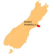
All Topics  
Banks Peninsula

 
Banks Peninsula

   Email Print
   Bookmark   Link


Banks Peninsula


Banks Peninsula is in the Canterbury
Canterbury, New Zealand

The Regions of New Zealand of Canterbury is mainly composed of the Canterbury Plains and the surrounding mountains. Its main city, Christchurch, hosts the main office of the Christchurch City Council, the Canterbury Regional Council and the University of Canterbury....
 region on the east coast of the South Island
South Island

The South Island is the larger of the two major Islands of New Zealand of New Zealand, the other being the more populous North Island. The Maori name for the South Island, Te Wai Pounamu, meaning "The Water/s of Greenstone" , possibly evolved from Te Wahi Pounamu which means "The Place Of Greenstone"....
 of New Zealand
New Zealand

New Zealand is an island country in the south-western Pacific Ocean comprising two main landmasses , and numerous Islands of New Zealand, most notably Stewart Island/Rakiura and the Chatham Islands....
, partly surrounded by the Pacific Ocean
Pacific Ocean

The Pacific Ocean is the largest of the Earth's oceanic divisions. Its name is derived from the Latin name Mare Pacificum, "peaceful sea", bestowed upon it by the Portugal explorer Ferdinand Magellan....
, and adjacent to the largest city in the South Island, Christchurch. The peninsula
Peninsula

A peninsula is a piece of Landform that is nearly surrounded by water but connected to mainland via an isthmus. Word origin: Latin paeninsula : paene, almost + insula, island....
 has a land area of approximately 1,000 kmē. The peninsula, including neighbouring areas that are not on the peninsula proper, was governed by the Banks Peninsula District Council from 1989 until 6 March 2006 when it was merged with neighbouring Christchurch City Council.


Discussion
Ask a question about 'Banks Peninsula'
Start a new discussion about 'Banks Peninsula'
Answer questions from other users
Full Discussion Forum


Encyclopedia


Nz Banks P
Banks Peninsula is in the Canterbury
Canterbury, New Zealand

The Regions of New Zealand of Canterbury is mainly composed of the Canterbury Plains and the surrounding mountains. Its main city, Christchurch, hosts the main office of the Christchurch City Council, the Canterbury Regional Council and the University of Canterbury....
 region on the east coast of the South Island
South Island

The South Island is the larger of the two major Islands of New Zealand of New Zealand, the other being the more populous North Island. The Maori name for the South Island, Te Wai Pounamu, meaning "The Water/s of Greenstone" , possibly evolved from Te Wahi Pounamu which means "The Place Of Greenstone"....
 of New Zealand
New Zealand

New Zealand is an island country in the south-western Pacific Ocean comprising two main landmasses , and numerous Islands of New Zealand, most notably Stewart Island/Rakiura and the Chatham Islands....
, partly surrounded by the Pacific Ocean
Pacific Ocean

The Pacific Ocean is the largest of the Earth's oceanic divisions. Its name is derived from the Latin name Mare Pacificum, "peaceful sea", bestowed upon it by the Portugal explorer Ferdinand Magellan....
, and adjacent to the largest city in the South Island, Christchurch. The peninsula
Peninsula

A peninsula is a piece of Landform that is nearly surrounded by water but connected to mainland via an isthmus. Word origin: Latin paeninsula : paene, almost + insula, island....
 has a land area of approximately 1,000 kmē. The peninsula, including neighbouring areas that are not on the peninsula proper, was governed by the Banks Peninsula District Council from 1989 until 6 March 2006 when it was merged with neighbouring Christchurch City Council. The population of the peninsula in 2001 was 7,833 residents (2001 census).

History

Three successive phases of Maori
Maori

The Maori are the indigenous people Polynesian people of Aotearoa . The group probably arrived in south-western Polynesia in several waves at some time before 1300....
 settlement took place on the peninsula which was known to Maori as Horomaka. Waitaha
Waitaha

Waitaha is an early historical Maori iwi. Inhabitants of the South Island of New Zealand, they were largely absorbed via marriage and conquest first by the Kati Mamoe and then Ngai Tahu from the 1500s onward....
 settled there first, followed by Kati Mamoe
Kati Mamoe

Kati Mamoe, or Ngati Mamoe, is an historic Maori iwi. Originally from the Heretaunga area they moved in the 1500s to the South Island which at the time was occupied by Waitaha....
 and then Ngai Tahu
Ngai Tahu

Ngai Tahu, or Kai Tahu, is the principal Maori iwi of the southern region of New Zealand, with the tribal authority, Te Runanga o Ngai Tahu, being based in Christchurch, New Zealand and Invercargill....
 took over in the 17th century.

The crew of Captain James Cook
James Cook

Captain James Cook Royal Society Royal Navy was an English explorer, navigator and cartographer, ultimately rising to the rank of Captain in the Royal Navy....
 became the first Europeans to sight the peninsula, during Cook's first circumnavigation of New Zealand in 1769, when he named the feature in honour of the Endeavour
HMS Endeavour

HMS Endeavour was the name of nine ships of the Royal Navy. Three ships of the Royal New Zealand Navy have been called HMNZS Endeavour....
s botanist, Joseph Banks
Joseph Banks

Sir Joseph Banks, 1st Baronet, Order of the Bath, President of the Royal Society was an England Natural history, Botany and patron of the natural sciences....
. The peninsula occasioned one of Cook's two major New Zealand cartographical errors - unable to see the low plains adjoining the peninsula, he charted it as an island. Distracted by a phantom sighting of land to the southeast, he sailed away before exploring any closer and never discovered the two good harbours.

By the 1830s, Banks Peninsula had become a European whaling
Whaling

Whaling is the hunting of whales and dates back to at least 4,000 BC. The evolution of traditional Arctic whaling developed with increasing rapidity with early organized fleets in the 17th century; competitive national whaling industries in the 18th and 19th centuries; and the introduction of factory ships along with the concept of whale "har...
 centre - to the detriment of the Maori, who succumbed in large numbers to disease and inter-tribal warfare exacerbated by the use of musket
Musket

A musket is a Muzzle -loaded, smoothbore long gun, which is intended to be fired from the shoulder.Usually, the musket is thought to be the weapon that replaced the arquebus, and was in turn replaced by the rifle....
s. Two significant events in the assumption of British sovereignty over New Zealand occurred at Akaroa
Akaroa

Akaroa is a village on Banks Peninsula in the Canterbury, New Zealand region of the South Island of New Zealand. It is 82 kilometres by road from Christchurch, New Zealand, and is the terminus of State Highway 75....
. First, in 1830 the Maori settlement at Takapuneke became the scene of a notorious incident. The Captain of the British brig
Elizabeth, John Stewart, helped North Island Ngati Toa
Ngati Toa

Ngati Toa , an iwi , traces its descent from the eponymous ancestor Toarangatira. The Ngati Toa region extends from Miria-te-kakara at Rangitikei District to Wellington, and across Cook Strait to Wairau River and Nelson, New Zealand....
 chief, Te Rauparaha
Te Rauparaha

Te Rauparaha was a Maori rangatira and war leader of the Ngati Toa tribe who took a leading part in the Musket Wars. He was influential in the original sale of land to the New Zealand Company and was a participant in the Wairau Incident in Marlborough, New Zealand....
, to capture the local Ngai Tahu chief, Te Maiharanui. The settlement of Takapuneke was sacked. (Partly as a result of this massacre, the British authorities sent an official British Resident, James Busby
James Busby

James Busby was involved in the drafting of the Declaration of the Independence of New Zealand and the Treaty of Waitangi, and is widely regarded as the "father" of the Australian wine industry, as he took the first collection of vine stock from Spain and France to Australia....
, to New Zealand in 1832 in an effort to stop such atrocities. The events at Takapuneke thus led directly to the signing of the Treaty of Waitangi
Treaty of Waitangi

The Treaty of Waitangi is a treaty first signed on February 6, 1840, by representatives of the United Kingdom The Crown, and various Maori chiefs from the northern North Island of New Zealand....
.) Then in 1838 Captain Langlois, a French whaler, decided that Akaroa would make a good settlement to service whaling ships and "purchased" the peninsula in a dubious land deal with the local Maori. He returned to France
France

France , officially the French Republic , is a country whose Metropolitan France is located in Western Europe and that also comprises various Overseas departments and territories of France....
, floated the Nanto-Bordelaise company, and set sail for New Zealand with a group of French and German families aboard the ship
Comte de Paris, with the intention of forming a French colony on a French South Island of New Zealand.

However, by the time Langlois and his colonists arrived at Banks Peninsula in August 1840, many Maori had already signed the Treaty of Waitangi (the signatories including two chiefs at Akaroa in May) and New Zealand's first British Governor, William Hobson
William Hobson

Captain William Hobson Royal Navy was the first Governor-General of New Zealand of New Zealand and co-author of the Treaty of Waitangi....
, had declared British sovereignty over the whole of New Zealand. On hearing of the French plan for colonisation, Hobson quickly dispatched the HMS
Britomart from the Bay of Islands to Akaroa with police magistrates on board. While Langlois and his colonists sheltered from unfavourable winds at Pigeon Bay on the other side of the peninsula, the British raised their flag at Greens Point between Akaroa and Takapuneke and courts of law convened to assert British sovereignty over the South Island.

From the 1850s, Lyttelton
Lyttelton, New Zealand

Lyttelton is a port town on the north shore of Lyttelton Harbour next to Banks Peninsula, 12 km by road from Christchurch, New Zealand on the eastern coast of the South Island of New Zealand....
 and then Christchurch outgrew Akaroa
Akaroa

Akaroa is a village on Banks Peninsula in the Canterbury, New Zealand region of the South Island of New Zealand. It is 82 kilometres by road from Christchurch, New Zealand, and is the terminus of State Highway 75....
, which has developed into a holiday resort and retained many French influences as well as many of its nineteenth-century buildings.

Historic harbour defence works dating from 1874 onwards survive at Ripapa Island
Ripapa Island

File:Fort Jervois Ripapa Island.jpgRipapa Island, just off the shore of Lyttelton Harbour has played many roles in the history of New Zealand or Aotearoa....
 in Lyttelton Harbour
Lyttelton Harbour

Lyttelton Harbour is one of two major inlets in Banks Peninsula, on the coast of Canterbury, New Zealand, New Zealand. It is approximately 15 km in length, from its mouth to Teddington....
, and at Godley Head.

Geology

Banks Peninsula From Space
Bankspeninsulamodel
Banks Peninsula forms the most prominent volcanic feature of the South Island. Geologically, the peninsula comprises the eroded remnants of two large shield volcano
Shield volcano

A shield volcano is a large volcano with shallow-sloping sides. The name derives from a translation of "Skjaldbrei?ur", an Icelandic shield volcano whose name means "broad shield", from its resemblance to a warrior's shield....
es (Lyttelton formed first, then Akaroa). These formed due to intraplate volcanism between approximately eleven and eight million years ago (Miocene
Miocene

The Miocene is a Geologic time scale of the Neogene period and extends from about 23.03 to 5.33 million years before the present. As with other older geologic periods, the rock beds that define the start and end are well identified but the exact dates of the start and end of the period are uncertain....
) on a continental crust. The peninsula formed as offshore islands, with the volcanoes reaching to about 1,500 m above sea level. Two dominant craters formed Lyttelton
Lyttelton, New Zealand

Lyttelton is a port town on the north shore of Lyttelton Harbour next to Banks Peninsula, 12 km by road from Christchurch, New Zealand on the eastern coast of the South Island of New Zealand....
 and Akaroa
Akaroa

Akaroa is a village on Banks Peninsula in the Canterbury, New Zealand region of the South Island of New Zealand. It is 82 kilometres by road from Christchurch, New Zealand, and is the terminus of State Highway 75....
 Harbours. The Canterbury Plains formed from the erosion of the Southern Alps
Southern Alps

The Southern Alps is a mountain range which runs along the western side of the South Island of New Zealand. It forms a natural dividing range along the entire length of the South Island....
 (an extensive and high mountain range caused by the meeting of the Indo-Australian
Indo-Australian Plate

The Indo-Australian Plate is a major tectonic plate that includes the Australia and surrounding ocean, and extends northwest to include the Indian subcontinent and adjacent waters....
 and Pacific tectonic plate
Pacific Plate

The Pacific Plate is an oceanic tectonic plate beneath the Pacific Ocean.To the north the easterly side is a divergent boundary with the Explorer Plate, the Juan de Fuca Plate and the Gorda Plate forming respectively the Explorer Ridge, the Juan de Fuca Ridge and the Gorda Ridge....
s) and from the alluvial fan
Alluvial fan

An alluvial fan is a fan -shaped deposition formed where a fast flowing stream flattens, slows, and spreads typically at the exit of a canyon onto a flatter plain....
s created by large braided river
Braided river

Not to be confused with the River Braid, Ballymena, Northern Ireland. For other uses see Braid .A braided river is one of a number of channel types and has a channel that consists of a network of small channel s separated by small and often temporary islands called braid bars or, in British usage, aits or eyots....
s. These plains reach their widest point where they meet the hilly sub-region of Banks Peninsula. A layer of loess
Loess

Loess is a homogeneous, typically nonstratified, porous, friable,slightly coherent, often calcareous, fine-grained, silty, pale yellow or buff, windblown sediment....
, a rather unstable fine silt deposited by the foehn winds which bluster across the plains, covers the northern and western flanks of the peninsula. The portion of crater rim lying between Lyttelton Harbour and Christchurch city forms the Port Hills
Port Hills

The Port Hills are a range of hills running approximately east-west, between the port of Lyttelton, New Zealand and the city of Christchurch in Canterbury, New Zealand....
.

Land use

Estimates suggest that native forest once covered 98% of the peninsula. However, Maori and European settlers successively denuded the forest cover and less than 2% remains today, although some reforestation has started. European settlers have planted many English trees, notably walnut
Walnut

Walnuts are plants in the family Juglandaceae. They are deciduous trees, 10–40 meter s tall , with pinnate leaves 200?900 millimetres long , with 5–25 leaflets; the shoots have chambered pith, a character shared with the wingnut but not the hickory in the same family....
.

Hinewai Reserve
Hinewai Reserve

File:Gorse at Hinewai Reserve.JPGHinewai Reserve is a private nature reserve on Banks Peninsula in New Zealand.It started off as a 109 ha block bought by the Maurice White Native Forest Trust in September 1987 and is now comprised of 1230 ha of gorse and regenerating native The bush....
, a private nature reserve
Nature reserve

A nature reserve is a protected area of importance for wildlife, flora , fauna or features of geological or other special interest, which is reserved and managed for Conservation ethic and to provide special opportunities for study or research....
, has been established on the peninsula to allow for native forest to regenerate on land that was once farmed.

Several sites off the coast of the peninsula serve for mariculture
Mariculture

Mariculture is a specialized branch of aquaculture involving the cultivation of marine organisms for food and other products in the open ocean, an enclosed section of the ocean, or in tanks, ponds or Raceway which are filled with seawater....
 cultivation of mussel
Mussel

The common name mussel is used for members of several different families of clams or bivalve molluscs, from both saltwater and freshwater habitats....
s.

A large Marine Mammal Sanctuary, mainly restricting set-net fishing, surrounds much of the peninsula. This has the principal aim of the conservation of Hector's dolphin
Hector's Dolphin

Hector's Dolphin or White-headed Dolphin is the best-known of the four dolphins in the genus Cephalorhynchus. At about 1.4 m in length, it is one of the smallest cetaceans....
, the smallest of all dolphin
Dolphin

File:Bottlenose_Dolphin_KSC04pd0178.jpgDolphins are marine mammals that are closely related to whales and porpoises. There are almost forty species of dolphin in seventeen genus....
 species. Eco-tourism based around the playful dolphins has now become a significant industry in Akaroa.

A relatively small marine reserve
Marine reserve

For the United States Marine Corps Reserve see: Marine Forces ReserveA marine reserve is an area of the sea which has legal protection against fishing or development....
 called Pohatu centres on Flea Bay on the south-east side of the peninsula.

The Summit Road forms a notable feature on the peninsula. Built in the 1930s, the road is in two sections:
  • one section runs along the crest of the Port Hills from Godley Head (the northern head of Lyttelton Harbour) to Gebbies Pass at the head of the harbour
  • the other section runs around the crater rim of Akaroa Harbour from 'Hill Top' - the junction with the main Christchurch-Akaroa highway - to a point above Akaroa. Both roads afford spectacular views as well as providing vehicular access to many parks, walkways, and other recreational features.


Tourism

A popular attraction for trampers/bushwalkers is the Banks Peninsula Track
Banks Peninsula Track

The Banks Peninsula Track is a 35 kilometre tramping track on the Banks Peninsula on the South Island of New Zealand in the Canterbury, New Zealand region....
.

Statistics

  • Highest point: Mount Herbert (919 m)
  • Permanent population: 7600


External links