

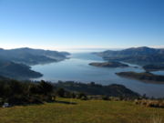
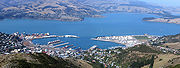
Lyttelton Harbour
Encyclopedia
Banks Peninsula
Banks Peninsula is a peninsula of volcanic origin on the east coast of the South Island of New Zealand. It has an area of approximately and encompasses two large harbours and many smaller bays and coves...
, on the coast of Canterbury
Canterbury, New Zealand
The New Zealand region of Canterbury is mainly composed of the Canterbury Plains and the surrounding mountains. Its main city, Christchurch, hosts the main office of the Christchurch City Council, the Canterbury Regional Council - called Environment Canterbury - and the University of Canterbury.-...
, New Zealand
New Zealand
New Zealand is an island country in the south-western Pacific Ocean comprising two main landmasses and numerous smaller islands. The country is situated some east of Australia across the Tasman Sea, and roughly south of the Pacific island nations of New Caledonia, Fiji, and Tonga...
. The other is Akaroa
Akaroa
Akaroa is a village on Banks Peninsula in the Canterbury region of the South Island of New Zealand, situated within a harbour of the same name—the name Akaroa is Kāi Tahu Māori for 'Long Harbour'.- Overview :...
Harbour.
Approximately 15 km in length from its mouth to Teddington, the harbour was formed from a series of ancient volcanic eruptions that created a caldera
Caldera
A caldera is a cauldron-like volcanic feature usually formed by the collapse of land following a volcanic eruption, such as the one at Yellowstone National Park in the US. They are sometimes confused with volcanic craters...
, the steep sides of which form the Port Hills
Port Hills
The Port Hills form the northern rim of the ancient Lyttelton volcano, separating the port of Lyttelton from the city of Christchurch in Canterbury, New Zealand...
on its northern shore.
The harbour's main population centre is Lyttelton
Lyttelton, New Zealand
Lyttelton is a port town on the north shore of Lyttelton Harbour close to Banks Peninsula, a suburb of Christchurch on the eastern coast of the South Island of New Zealand....
, which serves the city of Christchurch
Christchurch
Christchurch is the largest city in the South Island of New Zealand, and the country's second-largest urban area after Auckland. It lies one third of the way down the South Island's east coast, just north of Banks Peninsula which itself, since 2006, lies within the formal limits of...
, connected to Christchurch by the single-track Lyttelton rail tunnel
Lyttelton rail tunnel
The Lyttelton Rail Tunnel, initially called the Moorhouse Tunnel, links the city of Christchurch with the port of Lyttelton in the Canterbury region of New Zealand’s South Island. It is the country’s oldest operational rail tunnel, and is on one of the first railway lines in the district...
(opened 1867), a two lane road tunnel (opened 1964) and two roads over the Port Hills. Diamond Harbour
Diamond Harbour, New Zealand
Diamond Harbour is a small settlement on Banks Peninsula, in Canterbury, New Zealand. It is on the peninsula's northern coast, on the southern shores of Lyttelton Harbour, and is administratively part of the city of Christchurch....
lies to the south and the Māori village of Rāpaki to the west. At the head of the harbour is the settlement of Governors Bay. The reserve of Quail Island lies near the harbour head and Ripapa (Ripa) Island
Ripapa Island
Ripapa Island, just off the shore of Lyttelton Harbour has played many roles in the history of New Zealand. The island initially played a key role in an internal struggle for the south island Ngāi Tahu tribe in the early 19th Century...
is located just off its south shore at the entrance to Purau Bay.
Oil depot
An oil depot is an industrial facility for the storage of oil and/or petrochemical products and from which these products are usually transported to end users or further storage facilities...
and a modern container and cargo terminal
Container terminal
A container terminal is a facility where cargo containers are transshipped between different transport vehicles, for onward transportation. The transshipment may be between container ships and land vehicles, for example trains or trucks, in which case the terminal is described as a maritime...
.
The island of Ripapa has extensive fortifications and was used during World War I
World War I
World War I , which was predominantly called the World War or the Great War from its occurrence until 1939, and the First World War or World War I thereafter, was a major war centred in Europe that began on 28 July 1914 and lasted until 11 November 1918...
for the internment of German nationals, the most famous being Count Felix von Luckner
Felix von Luckner
Felix Graf von Luckner was a German nobleman, navy officer, author and noted sailor who earned the epithet Der Seeteufel -- and his crew that of Die Piraten des Kaisers -- for his exploits in command of the sailing commerce raider SMS Seeadler in...
. Quail Island was used as a leper colony
Leper colony
A leper colony, leprosarium, or lazar house is a place to quarantine leprous people.-History:Leper colonies or houses became widespread in the Middle Ages, particularly in Europe and India, and often run by monastic orders...
by early European settlers and has since become a nature reserve
Nature reserve
A nature reserve is a protected area of importance for wildlife, flora, fauna or features of geological or other special interest, which is reserved and managed for conservation and to provide special opportunities for study or research...
.
Hector's Dolphin
Hector's Dolphin
Hector's dolphin is the best-known of the four dolphins in the genus Cephalorhynchus and is found only in New Zealand. At about 1.4 m in length, it is one of the smallest cetaceans....
s, an endemic species to New Zealand can be found along with New Zealand Fur Seal
New Zealand Fur Seal
The Australian fur seal , or New Zealand fur seal or southern fur seal, is a species of fur seal found around the south coast of Australia, the coast of the South Island of New Zealand, and some of the small islands to the south and east of there...
s.