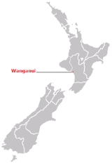
Home      Discussion      Topics      Dictionary      Almanac
Signup       Login
Wanganui

Wanganui

Overview
Wanganui is an urban area and district on the west coast of the North Island
North Island
The North Island is one of the two main islands of New Zealand, separated from the South Island by Cook Strait. The island is in area, making it the world's 14th-largest island...

 of New Zealand
New Zealand
New Zealand is an island country in the south-western Pacific Ocean comprising two main landmasses , and numerous smaller islands, most notably Stewart Island/Rakiura and the Chatham Islands. The indigenous Māori named New Zealand Aotearoa, commonly translated as The Land of the Long White Cloud...

. It is part of the Manawatu-Wanganui
Manawatu-Wanganui
Manawatu-Wanganui is a region in the lower half of the North Island of New Zealand, around the city of Palmerston North and the town of Wanganui.-Administration:...

 region.

Like several New Zealand centres, it was officially designated a city until administrative reorganisation in 1989, and is now run by a District Council. Despite this, it is still regarded as a city by most New Zealanders.

There is a recommendation from the New Zealand Geographic Board
New Zealand Geographic Board
The New Zealand Geographic Board is constituted under the New Zealand Geographic Board Act 2008, formerly under the New Zealand Geographic Board Act 1946. Although an independent institution, it is responsible to the Minister for Land Information...

 that the name be changed to "Whanganui", but this has yet to be approved by the Minister for Land Information.

Wanganui is located on the South Taranaki Bight
South Taranaki Bight
The South Taranaki Bight is the name given to the large bay which extends south and east from the south coast of Taranaki in New Zealand's North Island. With more symmetry than poetry or originality, it is matched by the North Taranaki Bight to the north of Cape Egmont.The size of the bight...

, close to the mouth of the Whanganui River
Whanganui River
The Whanganui River is a major river in the North Island of New Zealand.Known for many years as the Wanganui River, the river's name reverted to Whanganui in 1991, according with the wishes of local iwi. Part of the reason was also to avoid confusion with the Wanganui River in the South Island...

.
Discussion
Ask a question about 'Wanganui'
Start a new discussion about 'Wanganui'
Answer questions from other users
Full Discussion Forum
 
Encyclopedia
Wanganui is an urban area and district on the west coast of the North Island
North Island
The North Island is one of the two main islands of New Zealand, separated from the South Island by Cook Strait. The island is in area, making it the world's 14th-largest island...

 of New Zealand
New Zealand
New Zealand is an island country in the south-western Pacific Ocean comprising two main landmasses , and numerous smaller islands, most notably Stewart Island/Rakiura and the Chatham Islands. The indigenous Māori named New Zealand Aotearoa, commonly translated as The Land of the Long White Cloud...

. It is part of the Manawatu-Wanganui
Manawatu-Wanganui
Manawatu-Wanganui is a region in the lower half of the North Island of New Zealand, around the city of Palmerston North and the town of Wanganui.-Administration:...

 region.

Like several New Zealand centres, it was officially designated a city until administrative reorganisation in 1989, and is now run by a District Council. Despite this, it is still regarded as a city by most New Zealanders.

There is a recommendation from the New Zealand Geographic Board
New Zealand Geographic Board
The New Zealand Geographic Board is constituted under the New Zealand Geographic Board Act 2008, formerly under the New Zealand Geographic Board Act 1946. Although an independent institution, it is responsible to the Minister for Land Information...

 that the name be changed to "Whanganui", but this has yet to be approved by the Minister for Land Information.

Wanganui City


Wanganui is located on the South Taranaki Bight
South Taranaki Bight
The South Taranaki Bight is the name given to the large bay which extends south and east from the south coast of Taranaki in New Zealand's North Island. With more symmetry than poetry or originality, it is matched by the North Taranaki Bight to the north of Cape Egmont.The size of the bight...

, close to the mouth of the Whanganui River
Whanganui River
The Whanganui River is a major river in the North Island of New Zealand.Known for many years as the Wanganui River, the river's name reverted to Whanganui in 1991, according with the wishes of local iwi. Part of the reason was also to avoid confusion with the Wanganui River in the South Island...

. It is 200 kilometres north of Wellington
Wellington
Wellington is the capital of New Zealand, at the southwestern tip of the North Island between Cook Strait and the Rimutaka Range. The Wellington urban area is the major population centre of the southern North Island and is New Zealand's third most populous urban area with residents. There are ...

 and 75 kilometres northwest of Palmerston North
Palmerston North
Palmerston North is the main city of the Manawatu-Wanganui region of the North Island of New Zealand. It is an inland city with a population of In 2008 it was the 11th-largest city in New Zealand, and the centre of the seventh-largest urban area...

, at the junction of State Highways 3 and 4
New Zealand State Highway network
The New Zealand State Highway network is the major national highway network in New Zealand. Just under 100 roads in both the North and South Islands are State Highways...

. Most of the town lies on the river's northwestern bank, although some suburbs are located on the opposite side of the river.

It enjoys a temperate climate, with slightly above the national average sunshine (2100 hours per annum), and about 900 mm of annual rainfall. Several frosts are experienced in winter.

It is administered by Wanganui District Council. The current mayor is Michael Laws
Michael Laws
Michael Laws is a New Zealand politician, broadcaster and writer/columnist. He served two terms as a Member of the New Zealand Parliament, representing the National Party and New Zealand First . He was elected as Mayor of Wanganui in 2004 and won re-election in 2007...

.

History


The area around the mouth of the Whanganui was a major site of pre-European Māori
Māori
The Māori are the indigenous Polynesian people of New Zealand . The group probably arrived in southwestern Polynesia in several waves at some time before 1300...

 settlement. In the 1820s coastal tribes in the area assaulted the Kapiti Island
Kapiti Island
Kapiti Island is a small but conspicuous island about 8 km off the west coast of the lower North Island of New Zealand. It is 10 kilometres long, running southwest/northeast, and roughly 2 kilometres wide, being more or less rectangular in shape, and has an area of 19.65 km² .The island...

 of Ngāti Toa
Ngati Toa
Ngāti Toa , an iwi , traces its descent from the eponymous ancestor Toarangatira. The Ngāti Toa region extends from Miria-te-kakara at Rangitikei to Wellington, and across Cook Strait to Wairau and Nelson....

 chief Te Rauparaha
Te Rauparaha
Te Rauparaha was a Māori rangatira and war leader of the Ngāti Toa tribe who took a leading part in the Musket Wars. He was influential in the original sale of land to the New Zealand Company and was a participant in the Wairau Incident in Marlborough.- Early days :At some time around 1815,...

. Te Rauparaha retaliated in 1830 sacking Putiki
Pa (Maori)
The word pā traditionally refers to a Māori village or settlement. In contemporary Western usage, it has come to refer to a Māori hillfort from the 17th - 19th centuries, that was fortified with palisades and earthworks such as defensive terraces. Prior to the 1960s, any Māori settlement,...

 and slaughtering the inhabitants.
The first European traders arrived in 1831, followed in 1840 by missionaries Octavius Hadfield
Octavius Hadfield
Octavius Hadfield was Archdeacon of Kapiti, Bishop of Wellington from 1870 to 1893 and Primate of New Zealand from 1890 to 1893. A missionary for thirty years, he was recognised as an authority on Maori customs and language...

 and Henry Williams
Henry Williams
United States* Henry Williams : Member of the U.S. House of Representatives from Massachusetts in the 1840s* Henry Williams , pastor of Gillfield Baptist Church, Virginia and elected to Petersburg, VA City Council during Reconstruction* Henry L...

 who collected signatures for the Treaty of Waitangi
Treaty of Waitangi
The Treaty of Waitangi is a treaty first signed on February 6, 1840, by representatives of the British Crown, and various Māori chiefs from the northern North Island of New Zealand. The Treaty established a British governor in New Zealand, recognised Māori ownership of their lands and other...

. After the New Zealand Company
New Zealand Company
The New Zealand Company originated in 1839 in London with the aim of promoting the "systematic" colonisation of New Zealand. The Company intended to follow the colonising principles of Edward Gibbon Wakefield, who envisaged the creation of a new-model English society in the southern hemisphere...

 had settled in Wellington
Wellington
Wellington is the capital of New Zealand, at the southwestern tip of the North Island between Cook Strait and the Rimutaka Range. The Wellington urban area is the major population centre of the southern North Island and is New Zealand's third most populous urban area with residents. There are ...

 the company looked for more suitable places for settlers. Edward Wakefield, son of Edward Gibbon Wakefield
Edward Gibbon Wakefield
Edward Gibbon Wakefield was a British politician, the driving force behind much of the early colonization of South Australia, and later New Zealand. Wakefield, who in 1816 married Eliza Pattle , was the eldest son of Edward Wakefield and Susanna Crash...

, negotiated the sale of 40,000 acres in 1840. A town, originally known as Petre was established at the river mouth shortly after. The name was officially changed to Wanganui on 20 January 1854.

The early years of the new town were problematic. Purchase of land from the local tribes had been haphazard and irregular, and as such many Māori were angered with the influx of Pākehā
Pakeha
Pākehā are New Zealanders who are not of Māori blood lines. They are mostly descended from British and to a lesser extent Irish settlers of the nineteenth and twentieth centuries, although some Pākehā have Dutch, Scandinavian, German, Yugoslav or other ancestry...

 onto land that they still claimed. It was not until the town had been established for eight years that agreements were finally reached between the colonials and local tribes, and some resentment continued (and still filters through to the present day).

Wanganui grew rapidly after this time, with land being cleared for pasture. The town was a major military centre during the Land Wars
New Zealand land wars
The New Zealand Wars, sometimes called the Land Wars and also once called the Māori Wars, were a series of armed conflicts that took place in New Zealand between 1845 and 1872...

 of the 1860s, although local Māori at Putiki remained friendly to the town's settlers. In 1871 a town bridge was opened followed six years later by the railway bridge at Aramoho. The town was linked by rail to both New Plymouth
New Plymouth
New Plymouth is the major city of the Taranaki region on the west coast of the North Island of New Zealand. It is named after Plymouth, Devon, England, from where the first English settlers came....

 and Wellington
Wellington
Wellington is the capital of New Zealand, at the southwestern tip of the North Island between Cook Strait and the Rimutaka Range. The Wellington urban area is the major population centre of the southern North Island and is New Zealand's third most populous urban area with residents. There are ...

 by 1886.

Wanganui was incorporated as a Borough
Borough
A borough is an administrative division of various countries. In principle, the term borough designates a self-governing township although, in practice, official use of the term varies widely....

 on 1 February 1872 and declared a city on 1 July 1924.

Perhaps the city's biggest scandal happened in 1920, when the Mayor, Charles Mackay, shot and wounded a young poet, D'Arcy Cresswell, who had been blackmailing him over his homosexuality
Homosexuality
Homosexuality is the romantic or sexual attraction or behavior among members of the same sex, situationally or as an enduring disposition. As a sexual orientation, homosexuality is considered to lie within the heterosexual-homosexual continuum of human sexuality, and refers to an individual’s...

. Mackay served seven years in prison and his name was erased from the city's civic monuments, while Cresswell (himself homosexual) was praised as a "wholesome-minded young man".

The Whanganui River
Whanganui River
The Whanganui River is a major river in the North Island of New Zealand.Known for many years as the Wanganui River, the river's name reverted to Whanganui in 1991, according with the wishes of local iwi. Part of the reason was also to avoid confusion with the Wanganui River in the South Island...

 catchment is seen as a sacred area to Māori, and the Wanganui region is still seen as a focal point for any resentment over land ownership. In 1995, Moutoa Gardens
Moutoa Gardens
Moutoa Gardens, also known as Pakaitore, is a park in the city of Wanganui, New Zealand. Named after the Battle of Moutua Island in the Second Taranaki War, it contains a memorial to the battle inscribed “To the memory of the brave men who fell at Moutoa, 14 May 1864, in defence of law and order...

 in Wanganui, known to local Māori as Pakaitore, were occupied for 79 days in a mainly peaceful protest by the Whanganui iwi over land claims.

Wanganui was the site of the New Zealand Police
New Zealand Police
The New Zealand Police is the national police force of New Zealand, responsible for enforcing criminal law, enhancing public safety, maintaining order and keeping the peace throughout New Zealand...

 Law Enforcement System
National Law Enforcement System
The National Law Enforcement System, better known as the Wanganui Computer, was a database set up in 1976 by the State Services Commission in Wanganui, New Zealand...

(LES) from 1976 to 1995. An early Sperry
Sperry
-Persons:*Armstrong Sperry , American author and illustrator*Brett Sperry , American video game designer*Carlos A. Sperry, Democratic President of the West Virginia Senate from Greenbrier County, served 1872-1872...

 mainframe computer
Mainframe computer
Mainframes are computers used mainly by large organizations for critical applications, typically bulk data processing such as census, industry and consumer statistics, enterprise resource planning, and financial transaction processing.The term probably had originated from the early mainframes, as...

 based intelligence and data management system, it was known colloquially as the "Wanganui Computer". The data centre housing the LES was subject to New Zealand's highest profile suicide bombing in 1982 when anarchist Neil Roberts detonated a gelignite
Gelignite
Gelignite, also known as blasting gelatin, is an explosive material consisting of collodion-cotton dissolved in nitroglycerine and mixed with wood pulp and saltpetre...

 bomb in the entry foyer. Roberts was the only casualty of the bombing.

The name


Whāngā nui means big bay or big harbour. Europeans called it Petre (pronounced Peter), after Lord Petre, an officer of the New Zealand Company
New Zealand Company
The New Zealand Company originated in 1839 in London with the aim of promoting the "systematic" colonisation of New Zealand. The Company intended to follow the colonising principles of Edward Gibbon Wakefield, who envisaged the creation of a new-model English society in the southern hemisphere...

, but the name did not persist.

Wanganui or Whanganui?


In the local accent, Māori
Māori
The Māori are the indigenous Polynesian people of New Zealand . The group probably arrived in southwestern Polynesia in several waves at some time before 1300...

 say wh as w followed by a glottal stop, and the name as something like "W'anganui", hard to reproduce by non-locals. Until recently it was generally written as "Wanganui" and pronounced with a w by non-speakers of Māori
Māori
The Māori are the indigenous Polynesian people of New Zealand . The group probably arrived in southwestern Polynesia in several waves at some time before 1300...

 and a wh by those Māori speakers from other areas who knew its derivation.

Following an article about the river by David Young in the New Zealand Geographic
New Zealand Geographic
New Zealand Geographic is a magazine published in Auckland, New Zealand. It is in the format popularised by National Geographic but focusing on the biodiversity, geography and culture of New Zealand; New Zealand's interests abroad, and that of the adjoining region: Antarctica and nearby Pacific...

 magazine that used "Whanganui" throughout, in accord with the wishes of the local iwi
Iwi
In New Zealand society, iwi form the largest everyday social units in Māori populations. The word iwi means "people" or "folk"; in many contexts it may mean "tribe" or "clan", and sometimes a larger grouping of tribes...

, the spelling of the river's name reverted to Whanganui in 1991. The region's name is now sometimes also spelt "Whanganui", but the city has kept the spelling "Wanganui".

As a result, many people from outside the area now take pains to pronounce the river and the region as "Whanganui" and the city as "Wanganui", though the variant spellings do not reflect any difference in the underlying name.

A non-binding referendum
Referendum
A referendum , ballot question, or plebiscite is a direct vote in which an entire electorate is asked to either accept or reject a particular proposal...

 was held in Wanganui in 2006, where 82 percent voted for Wanganui without an 'h'. Turnout was 55.4 percent.http://www.stuff.co.nz/national/politics/2300853/Wanganui-spelling-change-slammed

In February 2009, the New Zealand Geographic Board
New Zealand Geographic Board
The New Zealand Geographic Board is constituted under the New Zealand Geographic Board Act 2008, formerly under the New Zealand Geographic Board Act 1946. Although an independent institution, it is responsible to the Minister for Land Information...

 received a proposal that the city's name should be spelt "Whanganui", and in late March found there was a good case for the change. The public was given three months to comment on the proposed change, beginning in mid May. About equal numbers of submissions supported and opposed the change. Wanganui Mayor Michael Laws spoke strongly against the proposed change. Another referendum was held in Wanganui in May 2009 and residents again rejected changing the city name 77-22. Turnout was 60%. The Geographic Board decided in September 2009 that the name should be spelled "Whanganui", but the decision will be reviewed by the Minister for Land Information.

City features


Prominent buildings of the city include the Sarjeant Art Gallery
Sarjeant Gallery
The Sarjeant Art Gallery is located in Queen's Park, Wanganui. The Gallery was built as the result of a bequest to the city by Henry Sarjeant in 1912, and is listed as a Category I Historic Place....

, and the Royal Wanganui Opera House
Royal Wanganui Opera House
The Royal Wanganui Opera House is New Zealand's last Victorian theatre. Located in St Hill Street in central Wanganui, the 106-year-old theatre seats 830 and is the venue for many local, national and international events....

, which was built in 1901.

Cook's Gardens are a major sporting venue, used for cricket, cycling, and athletics. On January 27 1962, a world record time for running the mile was set by Peter Snell
Peter Snell
Sir Peter George Snell, KNZM, OBE,KBE, is a former New Zealand athlete, now resident in Texas. He had one of the shortest careers of world famous international sportsmen, yet achieved so much that he was voted New Zealand’s "Sports Champion of the Century"...

 on the grass track at the gardens.

Much of the city is on the river's northwest bank. The river is crossed by four bridges - Cobham Bridge, City Bridge, Dublin Street Bridge and Aramoho Railway Bridge (rail and pedestrians only). Close to the southeast end of the City Bridge is one of Wanganui's more unusual features, an elevator leading to a monument on the top of Durie Hill.

Suburbs of the city include (clockwise from due south), Gonville, Castlecliff, Springvale, St. Johns Hill, Aramoho, Wanganui East, Bastia Hill, Durie Hill and Putiki. Of these, all except Wanganui East, Bastia Hill, Durie Hill and Putiki are on the northwest bank.

Economy


A considerable proportion of Wanganui's economy relates directly to the fertile and prosperous farming area that surrounds the city. Heads Road is Wanganui's main industrial area and s home to a number of manufacturing and engineering operations. The Wanganui Port, once the centre of industrial transport, still has some traffic but is more noted for the world famous Q-West Boat Builders, who operate from here.

Tourism is now becoming a major income stream for the district and the local Council has undertaken a number of tourism initiatives. Planning to relocate the local i-SITE Visitor Centre to a higher profile and specialised building is currently underway as well as the upgrading of a number of local landmarks (including the new riverfront walkway). Council has also taken actions to raise the profile of its main tourism wanganui.com website (http://www.wanganui.com) as this has been recognised as the leading source of information on Wanganui for visitor information.

Wanganui district


Wanganui District Council resulted from amalgamation of Wanganui and Waitotara county councils and Wanganui City Council.
The district has an area of 2,373 km². Much of the land in Wanganui district is rough hill country surrounding the valley of the Whanganui River. A large proportion of this is within the Whanganui National Park
Whanganui National Park
The Whanganui National Park is a national park located in the North Island of New Zealand. Established in 1986, it covers an area of 742 km² bordering the Whanganui River. It incorporates areas of Crown land, former state forest and a number of former reserves. The river itself is not technically...

.

All but some people in the Wanganui district live in the city itself, meaning there are few prominent outlying settlements. A small but notable village is Jerusalem
Jerusalem, New Zealand
Jerusalem was once an important kainga on the Whanganui River in New Zealand where a Roman Catholic mission was first established in 1854....

.

Sport

style="font-size:12px" align="bottom"> Sport Team's Colours
Blue
Black
Blue
Shorts/Skirt

Rugby


Wanganui is one of the oldest rugby
Rugby football
Rugby football may refer to a number of sports through history descended from a common form of football developed in different areas of the United Kingdom. Today it refers to either rugby league or rugby union.- History :...

 unions in New Zealand, but has never held the Ranfurly Shield
Ranfurly Shield
The Ranfurly Shield, colloquially known as the Log o' Wood, is perhaps the most prestigious trophy in New Zealand's domestic rugby union competition. First played for in 1904, the Ranfurly Shield is based on a challenge system, rather than a league or knockout competition as with most football...

. The Wanganui environs have produced many All Blacks
All Blacks
The New Zealand national rugby union team, known as the All Blacks, is the representative side of New Zealand in rugby union. Rugby union is regarded as the country's national sport...

 including Andrew Donald, Bill Osborne, Buff Milner, George Bullock-Douglas, Harrison Rowley, John Blair, John Hogan, Moke Belliss, Mona Thomson, Pat Potaka, Peina Taituha, Peter Johns, Peter McDonnell, Peter Murray, Peter Henderson, Sandy McNicol, Glenn Osborne and Keith Gudsell who also played three tests for the Wallabies
Australia national rugby union team
The Australian national rugby union team is the representative side of Australia in rugby union. The national team is nicknamed the Wallabies and competes annually with New Zealand and South Africa in the Tri-Nations Series, in which they also contest the Bledisloe Cup with New Zealand and the...

.

In 2008 the Wanganui representative rugby team under the captaincy of David Gower, won the NZRFU's Heartland Championship (Meads Cup) by defeating Mid Canterbury 27-12 in the final. They had previously been the defeated finalist in 2006 and 2007. The 2008 side had an undefeated season - the first since 1947. The rugby squad, including coach and management, was accorded the honour of 'Freedom of the City' by the Wanganui District Council - the first time the award had been given to any sporting team.

Sister cities


Toowoomba
Toowoomba, Queensland
Toowoomba is a city in South East Queensland, Australia. It is located west of Queensland's capital city, Brisbane. With an urban population of 95,265...

, Queensland
Queensland
Queensland is a state of Australia that occupies the north-eastern section of the mainland continent. It is bordered by the Northern Territory to the west, South Australia to the south-west and New South Wales to the south. To the east, Queensland is bordered by the Coral Sea and Pacific Ocean...

, Australia
Australia
Australia , officially the Commonwealth of Australia, is a country in the Southern Hemisphere comprising the continental mainland , the island of Tasmania, and numerous smaller islands in the Indian and Pacific Oceans...

 since 1983 Nagaizumi-cho
Nagaizumi, Shizuoka
is a town located in Suntō District, Shizuoka, Japan.As of 2009, the town has an estimated population of 39,865 and a density of 1,500 persons per km². The total area is 26.51 km².-Overview:...

, Japan
Japan
is an island country in East Asia. Located in the Pacific Ocean, it lies to the east of the Sea of Japan, People's Republic of China, North Korea, South Korea and Russia, stretching from the Sea of Okhotsk in the north to the East China Sea and Taiwan in the south...

 since 1988 Reno
Reno, Nevada
Reno is a city in and the county seat of Washoe County, Nevada, United States. The population was 180,480 at the 2000 census; in 2008, its population was estimated at 217,016, making it the fourth-largest city in the state after Las Vegas, Henderson and North Las Vegas, and the largest outside of...

, Nevada
Nevada
Nevada is a state located in the western region of the United States. The capital is Carson City and the largest city is Las Vegas. The state's nickname is Silver State, due to the large number of silver deposits that were discovered and mined there...

, USA was a sister city from 1974 to 2009.

External links