

Marlborough Sounds
Encyclopedia
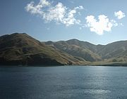
Ria
A ria is a coastal inlet formed by the partial submergence of an unglaciated river valley. It is a drowned river valley that remains open to the sea. Typically, rias have a dendritic, treelike outline although they can be straight and without significant branches. This pattern is inherited from the...
s created by a combination of land subsidence
Subsidence
Subsidence is the motion of a surface as it shifts downward relative to a datum such as sea-level. The opposite of subsidence is uplift, which results in an increase in elevation...
and rising sea levels at the north of the South Island
South Island
The South Island is the larger of the two major islands of New Zealand, the other being the more populous North Island. It is bordered to the north by Cook Strait, to the west by the Tasman Sea, to the south and east by the Pacific Ocean...
of New Zealand
New Zealand
New Zealand is an island country in the south-western Pacific Ocean comprising two main landmasses and numerous smaller islands. The country is situated some east of Australia across the Tasman Sea, and roughly south of the Pacific island nations of New Caledonia, Fiji, and Tonga...
. According to Māori mythology
Maori mythology
Māori mythology and Māori traditions are the two major categories into which the legends of the Māori of New Zealand may usefully be divided...
, the sounds are the prows of the sunken waka (canoe)
Waka (canoe)
Waka are Māori watercraft, usually canoes ranging in size from small, unornamented canoes used for fishing and river travel, to large decorated war canoes up to long...
of Aoraki.
Overview
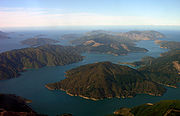
Covering some 4,000 km² of sounds, islands, and peninsulas, the Marlborough Sounds lie at the South Island's north-easternmost point, between Tasman BayTasman Bay
Tasman Bay is a large V-shaped bay at the north end of New Zealand's South Island. Located in the centre of the island's northern coast, it stretches along of coastline and is across at its widest point. It is an arm of the Tasman Sea, lying on the western approach to Cook Strait.At the bay's...
in the west and Cloudy Bay
Cloudy Bay
Cloudy Bay is located at the northeast of New Zealand's South Island, to the south of the Marlborough Sounds. The area lends its name to one of the best known New World white wines although the grapes used in production of that wine are grown in the Marlborough wine region further inland.The bay...
in the south-east. The almost fractal
Fractal
A fractal has been defined as "a rough or fragmented geometric shape that can be split into parts, each of which is a reduced-size copy of the whole," a property called self-similarity...
coastline has 1/5 of the length of New Zealand's coasts.
The steep, wooded hills and small quiet bays of the sounds are sparsely populated, as access is difficult. Many of the small settlements and isolated houses are only accessible by boat. The main large port is Picton
Picton, New Zealand
Picton is a town in the Marlborough region of New Zealand. It is close to the head of Queen Charlotte Sound near the north-east corner of the South Island. The population was 2928 in the 2006 Census, a decrease of 72 from 2001...
on the mainland, at the head of Queen Charlotte Sound
Queen Charlotte Sound, New Zealand
Queen Charlotte Sound is the easternmost of the main sounds of the Marlborough Sounds, in New Zealand's South Island. It is, like the other sounds, a drowned river valley , and like the majority of its neighbours it runs southwest to northeast before joining Cook Strait.The town of Picton, the...
. It is at the northern terminus of the South Island's main railway and State Highway
New Zealand State Highway network
The New Zealand State Highway network is the major national highway network in New Zealand. Just under 100 roads in both the North and South Islands are State Highways...
networks. The main small boat port is Waikawa
Waikawa, Marlborough
Waikawa is a small settlement to the north east of Picton, Marlborough, New Zealand. Waikawa Bay opens onto Queen Charlotte Sound.The population was 1158 in the 2006 Census, an increase of 168 from 2001....
which is one of New Zealand's largest and provides a base for leisure sailors and vacationers.
The main sounds, other than Queen Charlotte Sound, are Pelorus Sound
Pelorus Sound
Pelorus Sound is the largest of the sounds which make up the Marlborough Sounds at the north of the South Island, New Zealand. The Marlborough Sounds is a system of drowned river valleys, which were formed after the last ice age around 10,000 years ago...
and Kenepuru Sound
Kenepuru Sound
Kenepuru Sound is one of the larger of the Marlborough Sounds in the South Island of New Zealand. The drowned valley is an arm of Pelorus Sound, it runs for 25 kilometres from the northeast to southwest, joining Pelorus Sound a quarter of the way down the latter's path to the Cook Strait.Queen...
. Tory Channel
Tory Channel
Tory Channel is one of the drowned valleys that form the Marlborough Sounds in New Zealand.Tory Channel is named after the "Tory", a pioneer ship that brought British colonists to Wellington in 1840. It lies to the south of Arapawa Island, separating it from the mainland. At its western end it...
is a major arm of Queen Charlotte Sound, and between them they isolate the hills of Arapawa Island
Arapawa Island
Arapawa Island is a small island located in the Marlborough Sounds, at the north east tip of the South Island of New Zealand.The island has a land area of...
from the mainland. Other islands in the sounds include D'Urville Island
D'Urville Island, New Zealand
D'Urville Island is an island in the Marlborough Sounds along the northern coast of the South Island of New Zealand. It was named after the French explorer Jules Dumont d'Urville. With an area of approximately , it is the eighth-largest island of New Zealand, and has around 52 permanent...
.
The DOC manages a total of over 50 reserves in the area.
Pre-modern era
The sounds were extensively travelled and partly inhabited by Māori groups before the coming of the Europeans, using the sounds as shelter from bad weather and partaking of the rich food sources. They were also known to carry their canoes over some stretches of land on portagePortage
Portage or portaging refers to the practice of carrying watercraft or cargo over land to avoid river obstacles, or between two bodies of water. A place where this carrying occurs is also called a portage; a person doing the carrying is called a porter.The English word portage is derived from the...
paths. However, like in most areas of the South Island, populations were smaller than in the North Island.
European history of the area is considered to start with Captain Cook's visit to the sounds in 1770s, discovering a plant (Cooks Scurvy Grass) high in vitamin C
Vitamin C
Vitamin C or L-ascorbic acid or L-ascorbate is an essential nutrient for humans and certain other animal species. In living organisms ascorbate acts as an antioxidant by protecting the body against oxidative stress...
which helped to cure scurvy
Scurvy
Scurvy is a disease resulting from a deficiency of vitamin C, which is required for the synthesis of collagen in humans. The chemical name for vitamin C, ascorbic acid, is derived from the Latin name of scurvy, scorbutus, which also provides the adjective scorbutic...
amongst his crew. On Motuara Island, Cook also proclaimed British sovereignty over the South Island. Some parts of the sounds also later developed a significant whaling
Whaling
Whaling is the hunting of whales mainly for meat and oil. Its earliest forms date to at least 3000 BC. Various coastal communities have long histories of sustenance whaling and harvesting beached whales...
history, and much of the sounds was (thinly) settled by European farmers in the late 19th and early 20th century.
Ferries and marine farms
Cook Strait
Cook Strait is the strait between the North and South Islands of New Zealand. It connects the Tasman Sea on the west with the South Pacific Ocean on the east....
at the north-east extreme. At this point, the North Island
North Island
The North Island is one of the two main islands of New Zealand, separated from the much less populous South Island by Cook Strait. The island is in area, making it the world's 14th-largest island...
is at its closest to the South Island, and the inter-island road, rail, and passenger ferry
Ferry
A ferry is a form of transportation, usually a boat, but sometimes a ship, used to carry primarily passengers, and sometimes vehicles and cargo as well, across a body of water. Most ferries operate on regular, frequent, return services...
service between Picton and Wellington travels through the sounds.
Marine farming, especially of salmon
Salmon
Salmon is the common name for several species of fish in the family Salmonidae. Several other fish in the same family are called trout; the difference is often said to be that salmon migrate and trout are resident, but this distinction does not strictly hold true...
and mussel
Mussel
The common name mussel is used for members of several families of clams or bivalvia mollusca, from saltwater and freshwater habitats. These groups have in common a shell whose outline is elongated and asymmetrical compared with other edible clams, which are often more or less rounded or oval.The...
s, is increasingly common, having started in the 1960. However, the wake
Wake
A wake is the region of recirculating flow immediately behind a moving or stationary solid body, caused by the flow of surrounding fluid around the body.-Fluid dynamics:...
s caused by fast catamaran
Catamaran
A catamaran is a type of multihulled boat or ship consisting of two hulls, or vakas, joined by some structure, the most basic being a frame, formed of akas...
vehicular ferry services to the North Island have allegedly damaged farms and destroyed crab
Crab
True crabs are decapod crustaceans of the infraorder Brachyura, which typically have a very short projecting "tail" , or where the reduced abdomen is entirely hidden under the thorax...
grounds. They were also blamed for stripping the local beaches bare of sand, and damaging landings and other facilities built close to the water's edge. This resulted in a dispute heard in the New Zealand Environment Court in the early 1990s, brought forward by the 'Guardians of the Sounds' group. The court, however, not only refused to restrict the fast ferries, but also awarded NZ$ 300,000 in court costs against the citizen group which had brought the case. This was seen as a strong blow against civic action, and a curtailing of the powers of the Resource Management Act
Resource Management Act
The Resource Management Act passed in 1991 in New Zealand is a significant, and at times, controversial Act of Parliament. The RMA promotes the sustainable management of natural and physical resources such as land, air and water...
.
However, as damage increasingly became visible, and protests continued, the fast ferries (which only operated for the summer season) were eventually restricted to a lower speed of 18 kn in the sounds (officially for safety reasons), reducing their time advantage over the conventional ferries. They have since been discontinued.
In July/August 2007, the 'Guardians of the Sounds' environmentalist group planned a 100-ship flotilla protest against scallop
Scallop
A scallop is a marine bivalve mollusk of the family Pectinidae. Scallops are a cosmopolitan family, found in all of the world's oceans. Many scallops are highly prized as a food source...
dredging in the sounds, which they consider damages the ecosystem of the sounds similar to bottom trawling
Trawling
Trawling is a method of fishing that involves pulling a fishing net through the water behind one or more boats. The net that is used for trawling is called a trawl....
in the open sea. The protest was intended to call attention to what they allege is the Ministry of Fisheries ignoring the detrimental effect of the practice. Commercial scallops harvesting companies have warned that protests could endanger lives if the protesters engaged in dangerous manoeuvres, while the Ministry of Fisheries has also noted that only 6% of the sounds are set aside for the dredging, though this had been much more extensive in the past.
Dangerous waters
The main channels of the Marlborough Sounds have calm water and are popular for sailingSailing
Sailing is the propulsion of a vehicle and the control of its movement with large foils called sails. By changing the rigging, rudder, and sometimes the keel or centre board, a sailor manages the force of the wind on the sails in order to move the boat relative to its surrounding medium and...
. Cook Strait
Cook Strait
Cook Strait is the strait between the North and South Islands of New Zealand. It connects the Tasman Sea on the west with the South Pacific Ocean on the east....
, however, is infamous for its strong currents and rough waters, especially when the wind is from the south or north. Because of this, some of the narrow channels closer to the Strait are dangerous. Notable amongst these is French Pass
French Pass
French Pass is a narrow and treacherous stretch of water that separates D'Urville Island, at the north end of the South Island of New Zealand, from the mainland coast. At one end is Tasman Bay, and at the other end the outer Pelorus Sound leads out to Cook Strait.French Pass has the fastest tidal...
at the southern end of D'Urville Island, which has several vortices
Whirlpool
A whirlpool is a swirling body of water usually produced by ocean tides. The vast majority of whirlpools are not very powerful. More powerful ones are more properly termed maelstroms. Vortex is the proper term for any whirlpool that has a downdraft...
.
The most notable shipwreck in the sounds is that of the Russian cruise liner Mikhail Lermontov
Mikhail Lermontov (ship)
MS Mikhail Lermontov was an ocean liner owned by the Soviet Union's Baltic Shipping Company, built in 1972 by V.E.B. Mathias-Thesen Werft, Wismar, East Germany. She was later converted into a cruise ship...
, which sank in 1986 in Port Gore
Port Gore, New Zealand
Port Gore is a bay and natural harbour at the northern end of the Marlborough Sounds in New Zealand. It is located close to the northern tip of the South Island, at the western end of Cook Strait...
, close to the mouth of Queen Charlotte Sound, after striking rocks. One life was lost in the incident. The ship is now a popular dive wreck.