

Oruanui eruption
Encyclopedia
New Zealand
New Zealand is an island country in the south-western Pacific Ocean comprising two main landmasses and numerous smaller islands. The country is situated some east of Australia across the Tasman Sea, and roughly south of the Pacific island nations of New Caledonia, Fiji, and Tonga...
's Taupo Volcano
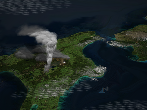
Taupo Volcano
Lake Taupo, in the centre of New Zealand’s North Island is not recognised as such by most people, but it is actually the Caldera of a large rhyolitic volcano...
was the world's largest known eruption in the past 70,000 years, with a Volcanic Explosivity Index
Volcanic Explosivity Index
The Volcanic Explosivity Index was devised by Chris Newhall of the U.S. Geological Survey and Stephen Self at the University of Hawaii in 1982 to provide a relative measure of the explosiveness of volcanic eruptions....
of 8. It occurred around 26,500 years ago in the Late Pleistocene
Late Pleistocene
The Late Pleistocene is a stage of the Pleistocene Epoch. The beginning of the stage is defined by the base of the Eemian interglacial phase before the final glacial episode of the Pleistocene 126,000 ± 5,000 years ago. The end of the stage is defined exactly at 10,000 Carbon-14 years BP...
and generated approximately 430 km³ (103.2 cu mi) of pyroclastic fall
Pyroclastic fall
A pyroclastic fall is a uniform deposit of material which has been ejected from a volcanic eruption or plume such as an ash fall or tuff. Pyroclastic air fall deposits are a result of:...
deposits, 320 km³ (76.8 cu mi) of pyroclastic density current (PDC) deposits (mostly ignimbrite
Ignimbrite
An ignimbrite is the deposit of a pyroclastic density current, or pyroclastic flow, a hot suspension of particles and gases that flows rapidly from a volcano, driven by a greater density than the surrounding atmosphere....
) and 420 km³ (100.8 cu mi) of primary intracaldera material, equivalent to 530 km³ (127.2 cu mi) of magma
Magma
Magma is a mixture of molten rock, volatiles and solids that is found beneath the surface of the Earth, and is expected to exist on other terrestrial planets. Besides molten rock, magma may also contain suspended crystals and dissolved gas and sometimes also gas bubbles. Magma often collects in...
. The eruption is divided into 10 phases on the basis of nine mappable fall units and a tenth, poorly preserved but volumetrically dominant fall unit.
Modern Lake Taupo
Lake Taupo
Lake Taupo is a lake situated in the North Island of New Zealand. With a surface area of , it is the largest lake by surface area in New Zealand, and the second largest freshwater lake by surface area in geopolitical Oceania after Lake Murray ....
partly fills the caldera
Caldera
A caldera is a cauldron-like volcanic feature usually formed by the collapse of land following a volcanic eruption, such as the one at Yellowstone National Park in the US. They are sometimes confused with volcanic craters...
generated during this eruption; a 140 km² (54.1 sq mi) structural collapse area is concealed beneath the lake, while the lake outline reflects coeval peripheral and volcano-tectonic collapse. Early eruption phases saw shifting vent positions; development of the caldera to its maximum extent (indicated by lithic lag breccia
Breccia
Breccia is a rock composed of broken fragments of minerals or rock cemented together by a fine-grained matrix, that can be either similar to or different from the composition of the fragments....
s) occurred during phase 10.
The Oruanui eruption shows many unusual features; its episodic nature, wide range of depositional conditions in fall deposits of very wide dispersal, and complex interplay of falls and pyroclastic flows.
Tephra
Tephra
200px|thumb|right|Tephra horizons in south-central [[Iceland]]. The thick and light coloured layer at center of the photo is [[rhyolitic]] tephra from [[Hekla]]....
from the eruption covered much of the central North Island
North Island
The North Island is one of the two main islands of New Zealand, separated from the much less populous South Island by Cook Strait. The island is in area, making it the world's 14th-largest island...
with ignimbrite up to 200 metres (656.2 ft) deep. Most of New Zealand was affected by ashfall, with even an 18 cm (7 in) ash layer left on the Chatham Islands
Chatham Islands
The Chatham Islands are an archipelago and New Zealand territory in the Pacific Ocean consisting of about ten islands within a radius, the largest of which are Chatham Island and Pitt Island. Their name in the indigenous language, Moriori, means Misty Sun...
, 1000 km (621.4 mi) away. Later erosion and sedimentation had long-lasting effects on the landscape, and caused the Waikato River
Waikato River
The Waikato River is the longest river in New Zealand. In the North Island, it runs for 425 kilometres from the eastern slopes of Mount Ruapehu, joining the Tongariro River system and emptying into Lake Taupo, New Zealand's largest lake. It drains Taupo at the lake's northeastern edge, creates the...
to shift from the Hauraki Plains
Hauraki Plains
The Hauraki Plains are a geographical feature and non-administrative area located in the northern North Island of New Zealand, at the lower end of the Thames Valley...
to its current course through the Waikato to the Tasman Sea
Tasman Sea
The Tasman Sea is the large body of water between Australia and New Zealand, approximately across. It extends 2,800 km from north to south. It is a south-western segment of the South Pacific Ocean. The sea was named after the Dutch explorer Abel Janszoon Tasman, the first recorded European...
.