

Bay of Islands
Encyclopedia
North Island
The North Island is one of the two main islands of New Zealand, separated from the much less populous South Island by Cook Strait. The island is in area, making it the world's 14th-largest island...
of New Zealand
New Zealand
New Zealand is an island country in the south-western Pacific Ocean comprising two main landmasses and numerous smaller islands. The country is situated some east of Australia across the Tasman Sea, and roughly south of the Pacific island nations of New Caledonia, Fiji, and Tonga...
. Located 60 km north-west of Whangarei
Whangarei
Whangarei, pronounced , is the northernmost city in New Zealand and the regional capital of Northland Region. Although commonly classified as a city, it is officially part of the Whangarei District, administered by the Whangarei District Council a local body created in 1989 to administer both the...
, it is close to the northern tip of the country.
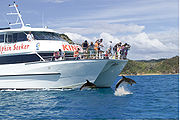
It is one of the most popular fishing, sailing and tourist destinations in the country, and has been renowned internationally for its big-game fishing since American author Zane Grey
Zane Grey
Zane Grey was an American author best known for his popular adventure novels and stories that presented an idealized image of the Old West. Riders of the Purple Sage was his bestselling book. In addition to the success of his printed works, they later had second lives and continuing influence...
publicised it in the 1930s.
Geography
The bay itself is an irregular 16 km-wide inlet in the north-eastern coast of the island. A natural harbour, it has several arms which extend into the land, notably Waikare Inlet in the south and KerikeriKerikeri
Kerikeri, the largest town in the Northland Region of New Zealand, is a popular tourist destination about three hours drive north of Auckland, and 80 km north of Whangarei...
and Te Puna (Mangonui) inlets in the north-west. The small town of Russell
Russell, New Zealand
Russell, formerly known as Kororareka, was the first permanent European settlement and sea port in New Zealand. It is situated in the Bay of Islands, in the far north of the North Island. As at the 2006 census it had a resident population of 816, an increase of 12 from 2001...
is located at the end of a short peninsula that extends into the bay from the southeast. Several islands lie to the north of this peninsula, notably Urupukapuka Island
Urupukapuka Island
Urupukapuka Island is an island in the Bay of Islands of New Zealand, located about 7.3 km from Paihia.-History:Urupukapuka Island was previously settled by the Ngare Raumati tribe, one of the oldest tribes of the area...
to the east and Moturoa Island to the north. The Purerua Peninsula
Purerua Peninsula
Purerua Peninsula is a peninsula on the northwest side of the Bay of Islands in Northland, New Zealand. Te Puna Inlet lies to the south of the peninsula. Communities on the peninsula are Purerua, Te Tii and Taronui Bay...
extends to the west of the bay, north of Te Puna Inlet, and Cape Brett
Cape Brett
Cape Brett is a promontory on the northern North Island coast in New Zealand. Located at the end of the Cape Brett Peninsula, the head extends north into the Pacific Ocean at the eastern end of the Bay of Islands....
Peninsula extends 10 km into the Pacific Ocean at the eastern end of the bay.
History
About 700 years ago, the MataatuaMataatua
In Māori tradition, Mataatua was one of the great voyaging canoes by which Polynesians migrated to New Zealand. Māori traditions say that the Mataatua was initially sent from Hawaiki to bring supplies of kūmara to Māori settlements in New Zealand...
, one of the large Māori migration canoes
Maori migration canoes
Various Māori traditions recount how their ancestors set out from their homeland in great ocean-going canoes . Some of these traditions name a mythical homeland called Hawaiki....
which journeyed to New Zealand from Hawaiki
Hawaiki
In Māori mythology, Hawaiki is the homeland of the Māori, the original home of the Māori, before they travelled across the sea to New Zealand...
, was sailed to the Bay Of Islands (from the Bay of Plenty) by Puhi, a progenitor of the Ngāpuhi
Ngapuhi
Ngāpuhi is a Māori iwi located in the Northland region of New Zealand, and centred in the Hokianga, the Bay of Islands and Whāngārei.Ngāpuhi has the largest affiliation of any New Zealand iwi, with 122,214 people registered , and formed from 150 hapu, with 55 marae.-Foundations:The founding...
Iwi (tribe)
Iwi
In New Zealand society, iwi form the largest everyday social units in Māori culture. The word iwi means "'peoples' or 'nations'. In "the work of European writers which treat iwi and hapū as parts of a hierarchical structure", it has been used to mean "tribe" , or confederation of tribes,...
which today is the largest in the country. Māori settled and multiplied throughout the bay and on several of its many islands to establish various tribes such as the Ngāti-Miru at Kerikeri
Kerikeri
Kerikeri, the largest town in the Northland Region of New Zealand, is a popular tourist destination about three hours drive north of Auckland, and 80 km north of Whangarei...
. Many notable Māori were born in the Bay Of Islands, including Hone Heke
Hone Heke
Hone Wiremu Heke Pokai was a Māori rangatira and war leader in Northern New Zealand and a nephew of Hongi Hika, an earlier war leader of the Ngāpuhi iwi. Hone Heke is considered the principal instigator of the Flagstaff War....
who several times cut down the flagpole at Kororareka (Russell)
Russell, New Zealand
Russell, formerly known as Kororareka, was the first permanent European settlement and sea port in New Zealand. It is situated in the Bay of Islands, in the far north of the North Island. As at the 2006 census it had a resident population of 816, an increase of 12 from 2001...
to start the Flagstaff War
Flagstaff War
The Flagstaff War – also known as Hone Heke's Rebellion, the Northern War and erroneously as the First Māori War – was fought between 11 March 1845 and 11 January 1846 in and around the Bay of Islands, New Zealand...
.
Many of the Māori settlements later played important roles in the development of New Zealand, such as Okiato
Okiato
Okiato or Old Russell is a small holiday spot in the Bay of Islands, New Zealand, seven km south of present-day Russell. It was New Zealand's first national capital, for a short time from 1840 to 1841, before the seat of government was moved to Auckland...
(the nation’s first capital), Waitangi
Waitangi, Northland
For the main port and settlement at the Chatham Islands, see Waitangi, Chatham IslandsWaitangi is a township located in the Bay of Islands on the North Island of New Zealand. It is located close to the town of Paihia , 60 kilometres north of Whangarei...
(where the Treaty of Waitangi
Treaty of Waitangi
The Treaty of Waitangi is a treaty first signed on 6 February 1840 by representatives of the British Crown and various Māori chiefs from the North Island of New Zealand....
would later be signed) and Kerikeri, (which was an important departure point for inland Māori going to sea, and later site of the first permanent mission station
Mission House
The Mission House at Kerikeri in New Zealand was completed in 1822 as part of the Kerikeri Mission Station by the Church Missionary Society, and is New Zealand’s oldest surviving building...
in the country). Some of the islands became notable as well, such as Te Pahi Island where 60 of Chief Te Pahi’s people were killed as revenge after he was wrongly accused of being responsible for the Boyd Massacre at Whangaroa
Whangaroa
Whangaroa is a locality on the harbour of the same name in Northland, New Zealand.Whangaroa is 8km north-west from Kaeo and 45km north from Okaihau. The harbour is almost landlocked and is popular both as a fishing spot in its own right and as a base for deep-sea fishing.The harbour was the scene...
.
The first European to visit the area was Captain Cook, who named the region in 1769. The Bay of Islands was the first area in New Zealand to be settled by Europeans. Whaler
Whaler
A whaler is a specialized ship, designed for whaling, the catching and/or processing of whales. The former included the whale catcher, a steam or diesel-driven vessel with a harpoon gun mounted at its bows. The latter included such vessels as the sail or steam-driven whaleship of the 16th to early...
s arrived towards the end of the 18th century, while the first missionaries settled in 1814. The first full-blooded European child recorded as being born in the country, Thomas King, was born in 1815 at Oihi Bay in the Bay of Islands. (There have been unsubstantiated claims that a European girl was born earlier at the Dusky Sound
Dusky Sound
Dusky Sound is a fiord on the south west corner of New Zealand, in Fiordland National Park.-Geography:One of the most complex of the many fjords on this coast, it is also one of the largest, 40 kilometres in length and eight kilometres wide at its widest point...
settlement in the South Island
South Island
The South Island is the larger of the two major islands of New Zealand, the other being the more populous North Island. It is bordered to the north by Cook Strait, to the west by the Tasman Sea, to the south and east by the Pacific Ocean...
).
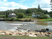
The bay has many interesting historic towns including Paihia
Paihia
Paihia is the main tourist town in the Bay of Islands in the far north of the North Island of New Zealand. It is located close to the historic towns of Russell, and Kerikeri, 60 kilometres north of Whangarei. The origin of the name Paihia is obscure. One, possibily apocryphal, attribution is to...
, Russell
Russell, New Zealand
Russell, formerly known as Kororareka, was the first permanent European settlement and sea port in New Zealand. It is situated in the Bay of Islands, in the far north of the North Island. As at the 2006 census it had a resident population of 816, an increase of 12 from 2001...
, Waitangi
Waitangi, Northland
For the main port and settlement at the Chatham Islands, see Waitangi, Chatham IslandsWaitangi is a township located in the Bay of Islands on the North Island of New Zealand. It is located close to the town of Paihia , 60 kilometres north of Whangarei...
and Kerikeri
Kerikeri
Kerikeri, the largest town in the Northland Region of New Zealand, is a popular tourist destination about three hours drive north of Auckland, and 80 km north of Whangarei...
. Russell, formerly known as Kororareka, was the first permanent European settlement in New Zealand, and dates from the early 19th century. Kerikeri contains many historic sites from the earliest European colonial settlement in the country. These include the Mission House
Mission House
The Mission House at Kerikeri in New Zealand was completed in 1822 as part of the Kerikeri Mission Station by the Church Missionary Society, and is New Zealand’s oldest surviving building...
, also called Kemp House, which is the oldest wooden structure still standing in New Zealand. The Stone Store
Stone Store
The Stone Store at Kerikeri in the Bay of Islands is New Zealand’s oldest surviving stone building.Part of the first Church Missionary Society station in New Zealand, the store was designed by John Hobbs to replace an earlier wooden store house. The Stone Store was erected between 1832 and 1836 by...
, a former storehouse, is the oldest stone building in New Zealand, construction having begun on 19 April 1832.
In a 2006 study, the Bay of Islands was found to have the second bluest sky
Diffuse sky radiation
Diffuse sky radiation is solar radiation reaching the Earth's surface after having been scattered from the direct solar beam by molecules or suspensoids in the atmosphere. It is also called skylight, diffuse skylight, or sky radiation and is the reason for changes in the colour of the sky...
in the world, after Rio de Janeiro
Rio de Janeiro
Rio de Janeiro , commonly referred to simply as Rio, is the capital city of the State of Rio de Janeiro, the second largest city of Brazil, and the third largest metropolitan area and agglomeration in South America, boasting approximately 6.3 million people within the city proper, making it the 6th...
.
The Cream Trip
In 1886, Albert Ernest Fuller launched the "Undine" sailing ship in the Bay of Islands to deliver coal supplies to the islands within the Bay. With the fitting of a motor in the early 20th century, Fuller was able to deliver the coal and essential supplies to communities as far out as Cape Brett.In 1927 Fuller acquired the "Cream Trip" from Eddie Lane - with the facilities on board to transport cream from the islands, and by the 1960s, the newly commissioned "Bay Belle" started this run. Although a modern catamaran now takes this historical route of the original The Cream Trip, the Bay Belle continues to transport visitors and locals between Paihia and Russell throughout the day.
External links
- Bay of Islands Travel Guide
- Fullers GreatSights Bay of Islands
- Bay of Islands information bayofislands.net
- Bay of Islands maps
- New Zealand Community site
- Bay of Islands Street Map
- Bay of Islands Area Guide
- The rock overnight cruise
- Carino Sailing and Dolphin Adventures
- Local & Tourist Information on the Bay of Islands