

Geology of Taranaki Region
Encyclopedia
The Taranaki Region of New Zealand
is built upon the Median Batholith in the West, and Greywacke
Rocks in the East. However, no rocks older than Miocene times are visible at the surface. The dominant feature of the Taranaki Region is the andesitic stratovolcano of Mount Taranaki
, which is only about 130,000 years old. The dissected hill country to the West of the Taranaki Peninsula, and East of the Central Volcanic Plateau (Ruapehu
and Tongariro) is composed of soft Miocene
to Pleistocene
sandstone
and mudstone
. The coastal lowlands around Wanganui
to the South have well-developed Quaternary marine terrace
s, and coastal sand dunes.
The Taranaki Basin is the only area in New Zealand with significant known oil and gas deposits, many of them offshore.
and Manaia.
To the East of this line are, in order, the Brook Street, Murihiku, Dun Mountain-Maitai, Caples, Waipapa (Morrinsville), and Torlesse (Kaweka) Terranes, mostly composed of Greywacke (apart from the Dun Mountain-Maitai Terrane).
All basement rocks are covered by more recent sediments.
times (37-34 Ma). The land sunk and the sea transgressed, and calcareous sandstone, mudstone, and limestone
were deposited in Oligocene
times (34-24 Ma). These rocks underlie more recent Miocene
rocks, around the Taranaki Peninsula and surrounding seas. The Eocene rocks often provide oil and gas deposits of the Taranaki Region. Mudstone anticlines often provide a suitable sealing cover.
The coastal lowlands around Wanganui
have well-developed Quaternary marine terraces (caused by sea-level fluctuations and tectonic uplift), and coastal sand dunes.
The volcanic plugs, Paritutu, forming part of New Plymouth’s harbour, and Sugar Loaf Islands, offshore from New Plymouth, are the remnants of a large volcano that erupted 1.8 Ma ago.
Kaitake, near the coast to the Northwest of Mount Taranaki, erupted 0.6 Ma ago.
Pouakai, on the Northwest side of Mount Taranaki, erupted around 255,000-215,000 years ago.
Pukeiti is probably around 17,000 years old.
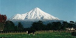 Mount Taranaki, together with its parasitic cone of Fanthams Peak, is the dominant topographical feature of the Taranaki Peninsula. The ancestral Taranaki volcano is likely to have existed for at least 130,000 years, repeatedly forming and collapsing over its history. The lava around Dawson Falls has been dated as 18,000 years old. The lava flows that formed the upper cone have been dated as no older than 7,000 years. Fanthams Peak has lava flows dated as 3,200 years old. The lava forming the dome of Mount Taranaki was emplaced in 1755 CE.
The Central Volcanic Plateau (Ruapehu and Tongariro), is also active. The main effects of eruptions from this area on the Taranaki Region, is the generation of Lahars down the Whangaehu River (from Ruapehu), and the Whanganui River (from both Ruapehu and Tongariro).
, Maui
, and Pohokura
(see also Oil and gas industry in New Zealand
). The rocks above the deposits have an appropriate shape, and are of a suitable composition to create a seal, and trap the oil and gas as it migrates up towards the surface. The continental shelf West of the Taranaki Peninsula is shallow, making it easy to drill for oil and gas.
The Taranaki Region is well known for its black sand, which is mined for iron and other products.
GNS provides a free Map of New Zealand's Geological Foundations.GNS Map of New Zealand's Geological Foundations
The main maps are the 1 : 250 000 QMap series, which will be completed as a series of 21 maps in 2010. Low resolution versions of these maps (without the associated booklet) can be downloaded from the GNS site for free. The map for the Taranaki Area was published in 2008.
New Zealand
New Zealand is an island country in the south-western Pacific Ocean comprising two main landmasses and numerous smaller islands. The country is situated some east of Australia across the Tasman Sea, and roughly south of the Pacific island nations of New Caledonia, Fiji, and Tonga...
is built upon the Median Batholith in the West, and Greywacke
Greywacke
Greywacke or Graywacke is a variety of sandstone generally characterized by its hardness, dark color, and poorly sorted angular grains of quartz, feldspar, and small rock fragments or lithic fragments set in a compact, clay-fine matrix. It is a texturally immature sedimentary rock generally found...
Rocks in the East. However, no rocks older than Miocene times are visible at the surface. The dominant feature of the Taranaki Region is the andesitic stratovolcano of Mount Taranaki
Mount Taranaki
Mount Taranaki, or Mount Egmont, is an active but quiescent stratovolcano in the Taranaki region on the west coast of New Zealand's North Island. Although the mountain is more commonly referred to as Taranaki, it has two official names under the alternative names policy of the New Zealand...
, which is only about 130,000 years old. The dissected hill country to the West of the Taranaki Peninsula, and East of the Central Volcanic Plateau (Ruapehu
Mount Ruapehu
Mount Ruapehu, or just Ruapehu, is an active stratovolcano at the southern end of the Taupo Volcanic Zone in New Zealand. It is 23 kilometres northeast of Ohakune and 40 kilometres southwest of the southern shore of Lake Taupo, within Tongariro National Park...
and Tongariro) is composed of soft Miocene
Miocene
The Miocene is a geological epoch of the Neogene Period and extends from about . The Miocene was named by Sir Charles Lyell. Its name comes from the Greek words and and means "less recent" because it has 18% fewer modern sea invertebrates than the Pliocene. The Miocene follows the Oligocene...
to Pleistocene
Pleistocene
The Pleistocene is the epoch from 2,588,000 to 11,700 years BP that spans the world's recent period of repeated glaciations. The name pleistocene is derived from the Greek and ....
sandstone
Sandstone
Sandstone is a sedimentary rock composed mainly of sand-sized minerals or rock grains.Most sandstone is composed of quartz and/or feldspar because these are the most common minerals in the Earth's crust. Like sand, sandstone may be any colour, but the most common colours are tan, brown, yellow,...
and mudstone
Mudstone
Mudstone is a fine grained sedimentary rock whose original constituents were clays or muds. Grain size is up to 0.0625 mm with individual grains too small to be distinguished without a microscope. With increased pressure over time the platey clay minerals may become aligned, with the...
. The coastal lowlands around Wanganui
Wanganui
Whanganui , also spelled Wanganui, is an urban area and district on the west coast of the North Island of New Zealand. It is part of the Manawatu-Wanganui region....
to the South have well-developed Quaternary marine terrace
Marine terrace
A marine terrace, coastal terrace, raised beach or perched coastline is a relatively flat, horizontal or gently inclined surface of marine origin, mostly an old abrasion platform which has been lifted out of the sphere of wave activity . Thus it lies above or under the current sea level, depending...
s, and coastal sand dunes.
The Taranaki Basin is the only area in New Zealand with significant known oil and gas deposits, many of them offshore.
Basement rocks
The Median Batholith lies to the West of a line between New PlymouthNew Plymouth
New Plymouth is the major city of the Taranaki Region on the west coast of the North Island of New Zealand. It is named after Plymouth, Devon, England, from where the first English settlers migrated....
and Manaia.
To the East of this line are, in order, the Brook Street, Murihiku, Dun Mountain-Maitai, Caples, Waipapa (Morrinsville), and Torlesse (Kaweka) Terranes, mostly composed of Greywacke (apart from the Dun Mountain-Maitai Terrane).
All basement rocks are covered by more recent sediments.
Te Kuiti Group Coal and Limestone
Throughout much of the West of the North Island, rocks containing coal were formed from swampland in Late EoceneEocene
The Eocene Epoch, lasting from about 56 to 34 million years ago , is a major division of the geologic timescale and the second epoch of the Paleogene Period in the Cenozoic Era. The Eocene spans the time from the end of the Palaeocene Epoch to the beginning of the Oligocene Epoch. The start of the...
times (37-34 Ma). The land sunk and the sea transgressed, and calcareous sandstone, mudstone, and limestone
Limestone
Limestone is a sedimentary rock composed largely of the minerals calcite and aragonite, which are different crystal forms of calcium carbonate . Many limestones are composed from skeletal fragments of marine organisms such as coral or foraminifera....
were deposited in Oligocene
Oligocene
The Oligocene is a geologic epoch of the Paleogene Period and extends from about 34 million to 23 million years before the present . As with other older geologic periods, the rock beds that define the period are well identified but the exact dates of the start and end of the period are slightly...
times (34-24 Ma). These rocks underlie more recent Miocene
Miocene
The Miocene is a geological epoch of the Neogene Period and extends from about . The Miocene was named by Sir Charles Lyell. Its name comes from the Greek words and and means "less recent" because it has 18% fewer modern sea invertebrates than the Pliocene. The Miocene follows the Oligocene...
rocks, around the Taranaki Peninsula and surrounding seas. The Eocene rocks often provide oil and gas deposits of the Taranaki Region. Mudstone anticlines often provide a suitable sealing cover.
Miocene to Recent Sediment
In early Miocene times (24 Ma), plate convergence caused regional compression. Since then, sedimentation has occurred throughout the Taranaki Region, generating sandstones, soft mudstones, and some limestone.The coastal lowlands around Wanganui
Wanganui
Whanganui , also spelled Wanganui, is an urban area and district on the west coast of the North Island of New Zealand. It is part of the Manawatu-Wanganui region....
have well-developed Quaternary marine terraces (caused by sea-level fluctuations and tectonic uplift), and coastal sand dunes.
Mohakatino Volcanic Arc
The volcanic arc that developed to the West of Northland and Auckland in Miocene times (23 Ma) extended further South towards Taranaki. These andesitic and basaltic volcanoes were mostly active in middle Miocene times (14-11 Ma), but some were still active in late Miocene times (5 Ma). They have all eroded away.Recent Volcanic Activity
Several largely andesitic volcanoes have erupted in Taranaki in the last two million years. They align in a Northwest-Southeast direction, generally getting younger to the Southeast. Mount Taranaki is the most recent, and still potentially active.The volcanic plugs, Paritutu, forming part of New Plymouth’s harbour, and Sugar Loaf Islands, offshore from New Plymouth, are the remnants of a large volcano that erupted 1.8 Ma ago.
Kaitake, near the coast to the Northwest of Mount Taranaki, erupted 0.6 Ma ago.
Pouakai, on the Northwest side of Mount Taranaki, erupted around 255,000-215,000 years ago.
Pukeiti is probably around 17,000 years old.
The Central Volcanic Plateau (Ruapehu and Tongariro), is also active. The main effects of eruptions from this area on the Taranaki Region, is the generation of Lahars down the Whangaehu River (from Ruapehu), and the Whanganui River (from both Ruapehu and Tongariro).
Geological Resources
The Taranaki Peninsula and surrounding sea provides New Zealand with its only known commercial oil and gas fields, including KapuniKapuni
Kapuni is a small hydrocarbons field and drilling site in the North Island of New Zealand. It is located within a dairy farming area in Taranaki, south of New Plymouth....
, Maui
Maui gas field
The Maui natural gas field is the largest gas, natural gas condensate and oil field in New Zealand, producing nearly three-quarters of the country's hydrocarbons, as well as providing energy for electricity generation. It is located in the Tasman Sea, 35 km off the coast of Taranaki and to the...
, and Pohokura
Pohokura field
The Pohokura field is an oil and gas field located 4 km offshore of north Taranaki in New Zealand, in approximately 30 m of water. The field was discovered in 2000 by Fletcher Challenge and has total estimated reserves of 996 Bcf of gas and 59.4 mmbbls of condensate.The field has 6 offshore and 3...
(see also Oil and gas industry in New Zealand
Oil and gas industry in New Zealand
The oil and gas industry in New Zealand explores and develops oil and gas fields, and produces petroleum products and natural gas.In 2008, New Zealand's self sufficiency in oil was 47%, i.e. the country imports over half its petroleum product needs...
). The rocks above the deposits have an appropriate shape, and are of a suitable composition to create a seal, and trap the oil and gas as it migrates up towards the surface. The continental shelf West of the Taranaki Peninsula is shallow, making it easy to drill for oil and gas.
The Taranaki Region is well known for its black sand, which is mined for iron and other products.
Geological Sites Worth Visiting
- Mount Taranaki is well worth hiking around.
- Paratutu and Sugar Loaf Islands can be seen near New Plymouth.
- The coastal highway North of Taranaki has rugged sandstone cliffs, and black sand beaches.
- The coastal highway from New Plymouth South to Wanganui is also of interest, with black sand beaches, and marine terraces.
- The highway from Stratford to Taumarunui, or Wanganui to Raetahi via the Whanganui River shows the sandstones and mudstones of the area.
Maps
Geological maps of New Zealand can be obtained from the New Zealand Institute of Geological and Nuclear Science (GNS Science), a New Zealand Government Research Institute.GNS provides a free Map of New Zealand's Geological Foundations.GNS Map of New Zealand's Geological Foundations
The main maps are the 1 : 250 000 QMap series, which will be completed as a series of 21 maps in 2010. Low resolution versions of these maps (without the associated booklet) can be downloaded from the GNS site for free. The map for the Taranaki Area was published in 2008.
Further reading
- Graham, Ian J. et al.;A continent on the move : New Zealand geoscience into the 21st century - The Geological Society of New Zealand in association with GNS Science, 2008. ISBN 9781877480003