

Geology of Northland Region, New Zealand
Encyclopedia
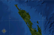
New Zealand
New Zealand is an island country in the south-western Pacific Ocean comprising two main landmasses and numerous smaller islands. The country is situated some east of Australia across the Tasman Sea, and roughly south of the Pacific island nations of New Caledonia, Fiji, and Tonga...
's Northland Region is built upon a basement
Basement (geology)
In geology, the terms basement and crystalline basement are used to define the rocks below a sedimentary platform or cover, or more generally any rock below sedimentary rocks or sedimentary basins that are metamorphic or igneous in origin...
consisting mainly of greywacke
Greywacke
Greywacke or Graywacke is a variety of sandstone generally characterized by its hardness, dark color, and poorly sorted angular grains of quartz, feldspar, and small rock fragments or lithic fragments set in a compact, clay-fine matrix. It is a texturally immature sedimentary rock generally found...
rocks, which are exposed on the eastern side of the peninsula. In-place Eocene
Eocene
The Eocene Epoch, lasting from about 56 to 34 million years ago , is a major division of the geologic timescale and the second epoch of the Paleogene Period in the Cenozoic Era. The Eocene spans the time from the end of the Palaeocene Epoch to the beginning of the Oligocene Epoch. The start of the...
coal measures outcrop at Kamo, near Whangarei
Whangarei
Whangarei, pronounced , is the northernmost city in New Zealand and the regional capital of Northland Region. Although commonly classified as a city, it is officially part of the Whangarei District, administered by the Whangarei District Council a local body created in 1989 to administer both the...
, and Oligocene
Oligocene
The Oligocene is a geologic epoch of the Paleogene Period and extends from about 34 million to 23 million years before the present . As with other older geologic periods, the rock beds that define the period are well identified but the exact dates of the start and end of the period are slightly...
limestone outcrops at Hikurangi, near Whangarei.
A subduction
Subduction
In geology, subduction is the process that takes place at convergent boundaries by which one tectonic plate moves under another tectonic plate, sinking into the Earth's mantle, as the plates converge. These 3D regions of mantle downwellings are known as "Subduction Zones"...
zone is believed to have existed to the northeast of Northland in early Miocene
Miocene
The Miocene is a geological epoch of the Neogene Period and extends from about . The Miocene was named by Sir Charles Lyell. Its name comes from the Greek words and and means "less recent" because it has 18% fewer modern sea invertebrates than the Pliocene. The Miocene follows the Oligocene...
times, causing the Northland Allochthon to thrust over much of the peninsula and volcanic belt
Volcanic belt
A volcanic belt is a large volcanically active region. Other terms are used for smaller areas of activity, such as volcanic fields. Volcanic belts are found above zones of unusually high temperature where magma is created by partial melting of solid material in the Earth's crust and upper mantle....
s to develop on either side of the peninsula. Intra-plate basaltic volcanic activity has occurred around Kaikohe
Kaikohe
Kaikohe is the central service area for the Far North District of New Zealand, about 260 km from Auckland, situated on State Highway 12 at...
, the Bay of Islands
Bay of Islands
The Bay of Islands is an area in the Northland Region of the North Island of New Zealand. Located 60 km north-west of Whangarei, it is close to the northern tip of the country....
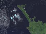
, and Whangarei since late Miocene times. Sand dunes sourced from volcanoes further south occupy much of the western coast, and the Aupouri Peninsula
Aupouri Peninsula
The Aupouri Peninsula is a tombolo at the northern tip of the North Island of New Zealand. It projects between the Tasman Sea to the west and the Pacific Ocean to the east...
joins previously separate islands to the mainland to form a large tombolo
Tombolo
A tombolo, from the Italian tombolo, derived from the Latin tumulus, meaning 'mound,' and sometimes translated as ayre , is a deposition landform in which an island is attached to the mainland by a narrow piece of land such as a spit or bar. Once attached, the island is then known as a tied island...
.
Basement rocks
As with most of New ZealandNew Zealand
New Zealand is an island country in the south-western Pacific Ocean comprising two main landmasses and numerous smaller islands. The country is situated some east of Australia across the Tasman Sea, and roughly south of the Pacific island nations of New Caledonia, Fiji, and Tonga...
, the basement rocks of the Northland Region are mainly composed of greywacke
Greywacke
Greywacke or Graywacke is a variety of sandstone generally characterized by its hardness, dark color, and poorly sorted angular grains of quartz, feldspar, and small rock fragments or lithic fragments set in a compact, clay-fine matrix. It is a texturally immature sedimentary rock generally found...
(indurated sandstone
Sandstone
Sandstone is a sedimentary rock composed mainly of sand-sized minerals or rock grains.Most sandstone is composed of quartz and/or feldspar because these are the most common minerals in the Earth's crust. Like sand, sandstone may be any colour, but the most common colours are tan, brown, yellow,...
), argillite
Argillite
An argillite is a fine-grained sedimentary rock composed predominantly of indurated clay particles. Argillaceous rocks are basically lithified muds and oozes. They contain variable amounts of silt-sized particles. The argillites grade into shale when the fissile layering typical of shale is...
, and chert
Chert
Chert is a fine-grained silica-rich microcrystalline, cryptocrystalline or microfibrous sedimentary rock that may contain small fossils. It varies greatly in color , but most often manifests as gray, brown, grayish brown and light green to rusty red; its color is an expression of trace elements...
, together with volcanic rock
Volcanic rock
Volcanic rock is a rock formed from magma erupted from a volcano. In other words, it is an igneous rock of volcanic origin...
s, such as basalt
Basalt
Basalt is a common extrusive volcanic rock. It is usually grey to black and fine-grained due to rapid cooling of lava at the surface of a planet. It may be porphyritic containing larger crystals in a fine matrix, or vesicular, or frothy scoria. Unweathered basalt is black or grey...
pillow lava
Pillow lava
Pillow lavas are lavas that contain characteristic pillow-shaped structures that are attributed to the extrusion of the lava under water, or subaqueous extrusion. Pillow lavas in volcanic rock are characterized by thick sequences of discontinuous pillow-shaped masses, commonly up to one metre in...
. The basement rocks are divided into a number of terrane
Terrane
A terrane in geology is short-hand term for a tectonostratigraphic terrane, which is a fragment of crustal material formed on, or broken off from, one tectonic plate and accreted or "sutured" to crust lying on another plate...
s, that are believed to have been combined together by subduction or strike-slip processes
Strike-slip tectonics
Strike-slip tectonics is concerned with the structures formed by, and the tectonic processes associated with, zones of lateral displacement within the crust or lithosphere.-Deformation styles:-Riedel shear structures:...
, by mid Cretaceous times (100 Ma).
Murihiku Terrane rocks lies beneath the Northland Region on the western side, but do not outcrop. The Murihiku Terrane was formed in Late Triassic
Triassic
The Triassic is a geologic period and system that extends from about 250 to 200 Mya . As the first period of the Mesozoic Era, the Triassic follows the Permian and is followed by the Jurassic. Both the start and end of the Triassic are marked by major extinction events...
to Late Jurassic
Jurassic
The Jurassic is a geologic period and system that extends from about Mya to Mya, that is, from the end of the Triassic to the beginning of the Cretaceous. The Jurassic constitutes the middle period of the Mesozoic era, also known as the age of reptiles. The start of the period is marked by...
times (220-145 Ma).
A line of Dun Mountain-Maitai Terrane rocks pass NNW-SSE through the centre of the Northland Region, separating the Murihiku Terrane from the more easterly terranes, and produce a detectable Junction Magnetic Anomaly (JMA), but do not outcrop.
Caples Terrane rocks outcrop to form the Waipapa Horst (Omahuta and Puketi forest area). The Caples Terrane was formed in Permian
Permian
The PermianThe term "Permian" was introduced into geology in 1841 by Sir Sir R. I. Murchison, president of the Geological Society of London, who identified typical strata in extensive Russian explorations undertaken with Edouard de Verneuil; Murchison asserted in 1841 that he named his "Permian...
to Triassic times (300-200 Ma).
Hunua Terrane rocks (part of the Waipapa Composite Terrane) outcrop throughout much of eastern Northland, south of Whangaroa. The rocks are generally fine grained and highly deformed. The Hunua Terrane was formed in Triassic to Jurassic times (250-145 Ma).
Mount Camel Terrane rocks outcrop near Mount Camel and the Karikari Peninsula. They were formed in the early Cretaceous
Cretaceous
The Cretaceous , derived from the Latin "creta" , usually abbreviated K for its German translation Kreide , is a geologic period and system from circa to million years ago. In the geologic timescale, the Cretaceous follows the Jurassic period and is followed by the Paleogene period of the...
(131-104 Ma).
Te Kuiti group coal and limestone
The Te Kuiti Group Rocks overlie the basement rocks, and are present in Northland, AucklandAuckland
The Auckland metropolitan area , in the North Island of New Zealand, is the largest and most populous urban area in the country with residents, percent of the country's population. Auckland also has the largest Polynesian population of any city in the world...
, the Waikato
Waikato
The Waikato Region is a local government region of the upper North Island of New Zealand. It covers the Waikato, Hauraki, Coromandel Peninsula, the northern King Country, much of the Taupo District, and parts of Rotorua District...
, and King Country
King Country
The King Country is a region of the western North Island of New Zealand. It extends approximately from the Kawhia Harbour and the town of Otorohanga in the north to the upper reaches of the Whanganui River in the south, and from the Hauhungaroa and Rangitoto Ranges in the east to near the Tasman...
, although they have often been eroded or covered. Rocks containing coal were formed from swampland in Late Eocene times (37-34 Ma). The land sank, the sea transgressed
Transgression (geology)
A marine transgression is a geologic event during which sea level rises relative to the land and the shoreline moves toward higher ground, resulting in flooding. Transgressions can be caused either by the land sinking or the ocean basins filling with water...
, and calcareous sandstone, mudstone
Mudstone
Mudstone is a fine grained sedimentary rock whose original constituents were clays or muds. Grain size is up to 0.0625 mm with individual grains too small to be distinguished without a microscope. With increased pressure over time the platey clay minerals may become aligned, with the...
, and limestone
Limestone
Limestone is a sedimentary rock composed largely of the minerals calcite and aragonite, which are different crystal forms of calcium carbonate . Many limestones are composed from skeletal fragments of marine organisms such as coral or foraminifera....
were deposited in Oligocene times (34-24 Ma).
Eocene coal measures outcrop in the east, between Kerikeri
Kerikeri
Kerikeri, the largest town in the Northland Region of New Zealand, is a popular tourist destination about three hours drive north of Auckland, and 80 km north of Whangarei...
and Waipu
Waipu
Waipu is a small town in Bream Bay, in the Northland Region of New Zealand, with a Scottish heritage. The population was 1,491 in the 2006 Census, an increase of 222 from 2001. A highlight of the town's calendar is the annual Highland Games held at New Year...
. Coal has been mined around Kamo
Kamo, New Zealand
Kamo is a small township north of Whangarei, approximately five minutes drive from the Whangarei CBD. The name is a Māori word meaning "eyelash", but has also been said to mean "to bubble up", referring to hot springs in the area. Mount Parakiore is a volcanic dome rising 391 m to the northwest of...
, north of Whangarei.
Limestone outcrops around Whangarei, with an interesting display at the Waro Rocks Scenic Reserve, north of Hikurangi.
The Northland Allochthon
In Early Miocene times (24-21 Ma), a series of thrust sheets was emplaced over Northland, extending as far south as the Kaipara HarbourKaipara Harbour
Kaipara Harbour is a large enclosed harbour estuary complex on the north western side of the North Island of New Zealand. The northern part of the harbour is administered by the Kaipara District and the southern part is administered by the Rodney District...
and Albany areas. The rocks came from the northeast (perhaps beyond the Vening Meinesz Fracture Zone), and were emplaced in reverse order, but the right way up. The original rocks are of Cretaceous to Oligocene age (90-25 Ma), and include mudstone, limestone and basalt lava
Lava
Lava refers both to molten rock expelled by a volcano during an eruption and the resulting rock after solidification and cooling. This molten rock is formed in the interior of some planets, including Earth, and some of their satellites. When first erupted from a volcanic vent, lava is a liquid at...
. The allochthon
Allochthon
thumb|right|250px|Schematic overview of a thrust system. The hanging wall block is called a [[nappe]]. If an [[erosion]]al hole is created in the nappe that is called a [[window |window]]...
includes displaced Te Kuiti group rocks. The basalt lava of the Tangihua Complex is believed to represent sea floor, that has been thrust onto Northland to form high standing massifs, such as the Reinga, Ahipara, Warawara, Mangakahia, and Maungataniwha massifs. Isolated bodies of serpentine occur at North Cape, and south of Maungaturoto.
The Northland and East Cape Allochthons are assumed to constitute part of a single allochthon, that have later separated, due to the clockwise rotation of the eastern part of the North Island, relative to the western part.
Early Miocene volcanism
Andesite
Andesite is an extrusive igneous, volcanic rock, of intermediate composition, with aphanitic to porphyritic texture. In a general sense, it is the intermediate type between basalt and dacite. The mineral assemblage is typically dominated by plagioclase plus pyroxene and/or hornblende. Magnetite,...
stratovolcano
Stratovolcano
A stratovolcano, also known as a composite volcano, is a tall, conical volcano built up by many layers of hardened lava, tephra, pumice, and volcanic ash. Unlike shield volcanoes, stratovolcanoes are characterized by a steep profile and periodic, explosive eruptions...
es. Most of these volcanoes have been eroded, but remnants form the Waipoua Plateau (basaltic, 19-18 Ma), and Waitakere Ranges (andesitic, 22-16 Ma).
An eastern volcanic belt formed mainly andesitic volcanoes around Karikari (22.3-19.8 Ma), Whangaroa (20.5-17.5 Ma), Whangarei Heads (21.5-16.1 Ma), Bream Head, and created the Hen and Chicken Islands (19.5-16.5 Ma).
Waitemata sandstone
Miocene volcanoes and the Northland Allochthon eroded to form the Waitemata sandstone, between Whangarei and Auckland, on the eastern side of Northland.Uplift
By middle Miocene, Northland was uplifted above sea level, with a slight westward tilt, exposing basement rocks on the eastern side, and resulting in a tendency for rivers to flow in a westerly direction.Recent basaltic volcanism
Intra-plate basaltic volcanism has occurred in Northland from late Miocene to QuaternaryQuaternary
The Quaternary Period is the most recent of the three periods of the Cenozoic Era in the geologic time scale of the ICS. It follows the Neogene Period, spanning 2.588 ± 0.005 million years ago to the present...
times. The Kerikeri volcanic group covered the area from Kaikohe, Kerikeri, to Whangarei. Activity began about 9 Ma, and the youngest cones are probably only tens of thousands of years old.
Little Barrier Island is the emergent part of a large dacitic
Dacite
Dacite is an igneous, volcanic rock. It has an aphanitic to porphyritic texture and is intermediate in composition between andesite and rhyolite. The relative proportions of feldspars and quartz in dacite, and in many other volcanic rocks, are illustrated in the QAPF diagram...
-rhyodacitic stratovolcano, formed through two eruptive periods (3 Ma, and 1.6-1.2 Ma).
Coastal dunes
Kaipara Harbour
Kaipara Harbour is a large enclosed harbour estuary complex on the north western side of the North Island of New Zealand. The northern part of the harbour is administered by the Kaipara District and the southern part is administered by the Rodney District...
, are essentially consolidated sand dunes, built up over the last few million years. Similar dunes have formed in the north from Ahipara
Ahipara
Ahipara is a town and locality in Northland, New Zealand. It is at the southern end of Ninety Mile Beach, with the Tauroa Peninsula to the west and Herekino Forest to the east. Ahipara Bay is to the north west...
to Cape Reinga
Cape Reinga
Cape Reinga is the northwesternmost tip of the Aupouri Peninsula, at the northern end of the North Island of New Zealand. Cape Reinga is located over 100 km north of the nearest small town of Kaitaia. State Highway 1 extends all the way to the Cape, but until 2010 was unsealed gravel road for the...
, connecting what used to be isolated islands
Tied island
Tied islands, or land-tied islands, as they are often known, are a landform where the island is only connected to land by a tombolo—a spit of beach materials connected to land at both ends. The Isle of Portland on the south coast of England is an example of this; it was once an island but is now...
to the rest of the North Island, thus creating a large tombolo
Tombolo
A tombolo, from the Italian tombolo, derived from the Latin tumulus, meaning 'mound,' and sometimes translated as ayre , is a deposition landform in which an island is attached to the mainland by a narrow piece of land such as a spit or bar. Once attached, the island is then known as a tied island...
. Sand on the eastern coast tends to be more pure quartz, and appears white.
Geothermal areas
Hot springs exist at Ngawha SpringsNgawha Springs
Ngawha Springs is a small settlement approximately five kilometres east of the town of Kaikohe, Northland in New Zealand.It is the location of Ngawha Springs, a hot water spring that reputedly has therapeutic properties for those who bathe in its waters, and is the source of the steam used at the...
, with temperatures around 40-50°C. There are also hot springs at Waiwera
Waiwera
Waiwera is a locality situated in the north of the Auckland Region in New Zealand. The name is of Māori origin and means "Hot Water" . Its main claim to fame are the hot water springs which were well-known in pre-European times and reputedly visited by Māori from as far away as Thames...
and Parakai
Parakai
Parakai is a township in the North Island of New Zealand. It is sited 43 kilometres northwest of Auckland, close to the southern extremity of the Kaipara Harbour...
, north of Auckland. All are used for hot pools. The Ngawha geothermal field
Ngawha geothermal field
The Ngawha geothermal field is a geothermal area in the North Island of New Zealand. It is situated approximately 5 km east of Kaikohe and is centred around the village of Ngawha Springs. The field covers an area of around 25 km² and as such, is much smaller than the only other geothermal...
is also used for the generation of electricity.
Geological resources
Copper has been mined at Kaeo, silver, gold and mercury at Puhipuhi, and antimony at Russell.Coal has been mined at Kawakawa, Hikurangi, Kamo and Kiripaka.
The Northland Basin, to the west of the Northland Peninsula is considered as having potential for oil
Petroleum
Petroleum or crude oil is a naturally occurring, flammable liquid consisting of a complex mixture of hydrocarbons of various molecular weights and other liquid organic compounds, that are found in geologic formations beneath the Earth's surface. Petroleum is recovered mostly through oil drilling...
and gas
Natural gas
Natural gas is a naturally occurring gas mixture consisting primarily of methane, typically with 0–20% higher hydrocarbons . It is found associated with other hydrocarbon fuel, in coal beds, as methane clathrates, and is an important fuel source and a major feedstock for fertilizers.Most natural...
.
Halloysite
Halloysite
Halloysite is a 1:1 aluminosilicate clay mineral with the empirical formula Al2Si2O54. Its main constituents are aluminium , silicon , and hydrogen . Halloysite typically forms by hydrothermal alteration of alumino-silicate minerals. It can occur intermixed with dickite, kaolinite, montmorillonite...
clay is mined at Matauri Bay and Mahimahi.
High quality quartz
Quartz
Quartz is the second-most-abundant mineral in the Earth's continental crust, after feldspar. It is made up of a continuous framework of SiO4 silicon–oxygen tetrahedra, with each oxygen being shared between two tetrahedra, giving an overall formula SiO2. There are many different varieties of quartz,...
sand is dredged from near Parengarenga Harbour.
Geological hazards
The main geological hazard in Northland is the potential for landslides, particularly in mudstones and sandstones of the Northland Allochthon. Northland has the least incidence of earthquakes of anywhere in New Zealand. However, tsunamiTsunami
A tsunami is a series of water waves caused by the displacement of a large volume of a body of water, typically an ocean or a large lake...
s generated by earthquake
Earthquake
An earthquake is the result of a sudden release of energy in the Earth's crust that creates seismic waves. The seismicity, seismism or seismic activity of an area refers to the frequency, type and size of earthquakes experienced over a period of time...
s around the Pacific can occur on the east coast.
Geological sites of interest
Hunua Terrane can be seen along much of the coast between the Bay of Islands and Whangarei. Mount Camel Terrane can be seen at Parerake Bay, Karikari Peninsula.Kamo coal measures can be seen near Kamo. Whangarei Limestone can be seen at Waro Rocks Scenic Reserve, north of Hikurangi.
Many of the hills in Northland are formed from the Tangihua Complex rocks of the Northland Allochthon.
Maungaraho, north of Tokatoka, gives a good example of a remnant of an early Miocene andesitic volcano. Whangarei Heads represents another example.
Sand dunes can be seen on either side of the coast between Kaitaia and Cape Reinga.
Maps
Geological maps of New Zealand can be obtained from the New Zealand Institute of Geological and Nuclear Science (GNS Science), a New Zealand Government Research Institute.GNS provides a free Map of New Zealand's Geological Foundations.GNS Map of New Zealand's Geological Foundations
The main maps are the 1 : 250 000 QMap series, which will be completed as a series of 21 maps and booklets in 2010. Low resolution versions of these maps (without the associated booklet) can be downloaded from the GNS site for free.
The map for the Kaitaia Area was published in 1996.
The map for the Whangarei Area was published in 2009.
The map for the Auckland Area was published in 2002.
There is also a 1 : 25 000 map of the Whangarei Urban Area, published in 2003.
Further reading
- Graham, Ian J. et al.;A continent on the move : New Zealand geoscience into the 21st century - The Geological Society of New Zealand in association with GNS Science, 2008. ISBN 9781877480003
- Christie, A. B. and Barker, R. G. (2007). Mineral resource assessment of the Northland Region, New Zealand. GNS Science science report 2007/06, May 2007.