

U.S. Highway 101 in California
Encyclopedia
In the U.S. state
of California
, U.S. Route 101 (US 101) is one of the last remaining and longest U.S. Routes
still active in the state, and the longest highway of any kind in California. US 101 was also one of the original U.S. Routes established in 1926.
Although it has been replaced in overall importance for transport through the state by Interstate 5
, US 101 remains a major coastal north–south route that links the Greater Los Angeles Area
, the Central Coast
, the San Francisco Bay Area
, and the North Coast.
, about one mile (1.6 km) east of downtown Los Angeles at the East Los Angeles Interchange
, also known as the "Commuters' Complex." This southernmost portion is named the Santa Ana Freeway
, inheriting that title as the northerly extension of the roadway now known as Interstate 5.
After merging with westbound traffic from the San Bernardino Freeway (I-10)
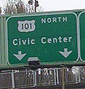
, U.S. Route 101 then proceeds northwest via the Downtown Slot under the northern edge of Los Angeles' Civic Center to State Route 110 at the Four Level Interchange
. From here, U.S. 101 becomes the Hollywood Freeway
. It then heads to Hollywood
and up through the Cahuenga Pass
before reaching the San Fernando Valley
.
Highway 101 then intersects with State Route 134 and State Route 170
at the interchange known as the Hollywood Split. Here, the alignment of U.S. 101 'shifts' to the alignment of SR 134 (i.e. heading northbound, the road's alignment turns left, or westbound) and thereafter is referred to as the Ventura Freeway
until it reaches Ventura
. Confusingly, the "Hollywood Freeway" name continues northward from this interchange on SR 170, and the "Ventura Freeway" name continues eastward to SR 134.
From the Hollywood Split, U.S. 101 is an east–west highway until it reaches Gaviota State Park
in Santa Barbara County
where it shifts back to a north–south alignment. Along the way, it meets with Interstate 405
. This interchange was named the worst interchange for traffic in the United States. The east–west geographical alignment of the Ventura Freeway and the north–south designation on freeway signs can be confusing to visitors; the same freeway entrance can often be signed as "101 North" and "101 West"; this is most common in the San Fernando Valley
.
Upon reaching Ventura, there is an interchange with SR 126, aka the Santa Paula Freeway.
. The last traffic signals along this stretch of the route were removed in the early 1990s when the section through downtown Santa Barbara
was constructed to freeway standards after years of resistance from the local community.
From Ventura and through Santa Barbara
, Highway 101 closely follows the Pacific coast
line (generally no more than one to two miles (3 km) from the shore
) until Gaviota State Park
, about 23 miles (37 km) west of Goleta
. At Gaviota State Park, the highway shifts back from an east–west highway to a north–south alignment. About 1 miles (1.6 km) north of this point, U.S. 101 passes through the Gaviota Tunnel
.
A few miles north of the Gaviota Tunnel, State Route 1 splits from U.S. 101 and heads northwest, running along the Pacific coastline parallel and to the west of U.S. 101.
Farther north, State Route 1
rejoins 101 for a section between Pismo Beach
and San Luis Obispo
. Then U.S. 101 takes an inland route through the Salinas Valley
, while Highway 1 heads northwest, running along the Pacific coastline in California, parallel and to the west of U.S. 101.
A steep segment (7% grade) between San Luis Obispo
and Atascadero
is known as the Cuesta Grade. North of Atascadero, the highway joins State Route 46 (SR 46) for about three miles (5 km) through Paso Robles
.
From Paso Robles to Salinas
, U.S. 101 is an expressway known as the Salinas River Valley Highway, since the Salinas River Valley extends from Santa Margarita
to the State Route 156 junction in Prunedale
. The highway passes Camp Roberts
south of Bradley
as well as the San Ardo Oil Field
about five miles (8 km) south of the town of San Ardo
. Near this point, the wide agricultural bottomlands of the Salinas Valley begins. Upon leaving Salinas, after going past the southern terminus of State Route 156, U.S. 101 remains mostly a four-lane highway until it reaches Gilroy
.
 When U.S. 101 reaches Gilroy
, it becomes the South Valley Freeway, and at the same time, it expands to three lanes in each direction. It then heads through the suburb
of Morgan Hill
, but shortly afterwards expands to four lanes in each direction before reaching San Jose
. From San Jose to San Francisco, Highway 101 is known as the Bayshore Freeway
as it passes through Palo Alto
and the other major communities along the San Francisco Peninsula
. This segment was originally Bayshore Boulevard, later redesignated the 101A bypass and upgraded to freeway by the late 1950s. This section of 101 from San Jose north to San Francisco is very heavily travelled. The stretch between Redwood City and South San Francisco was the Bay Area's first freeway when it opened in 1947; over the next 20 years the stretches from San Jose to Redwood City and South San Francisco to San Francisco were upgraded to freeway.
 Highway 101 is called the James Lick Freeway, named for James Lick
, a philanthropist
, from the San Francisco county/city line, through the interchange with I-280
at the Alemany Maze
, until the junction with the San Francisco Skyway (Interstate 80) and the Central Freeway
near the city's Civic Center
. Highway 101 continues in a northwestern direction on the Central Freeway, and then leaves the freeway to run north on Van Ness Avenue. At the intersection of Van Ness Avenue and Lombard Street
, Highway 101 heads west on Lombard Street, and then on Richardson Avenue, entering The Presidio
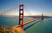
, where it becomes a divided highway again (known as Doyle Drive). It is then joined by Route 1 before approaching and crossing the Golden Gate Bridge
.
From San Francisco north the highway is heavily traveled by commuters through to Windsor, just north of Santa Rosa. North of the Golden Gate Bridge, U.S. 101 enters Marin County
and is known as the Redwood Highway. After crossing the bridge, U.S. 101 climbs the Waldo Grade
and passes through the Waldo Tunnel, the first of its kind in 300 miles (the other being the Gaviota Tunnel
in Santa Barbara County), before passing through San Rafael
and Novato
. The section between Novato in Marin County and Petaluma
in Sonoma County
changes from its original six or eight lanes through Marin to four lanes, and is thus called the "Novato Narrows" by locals. The entire area between Novato and Petaluma is also the voter approved Novato–Petaluma Community Separator, which forbids most development.
Upon entering Sonoma County it continues as a four lane freeway until Santa Rosa, where it turns into a six-lane freeway to Windsor. (In Cotati
and Rohnert Park
, the freeway is under construction, being expanded from four lanes to six.) After leaving Healdsburg, it proceeds up the Alexander Valley
with the Russian River
before leaving Sonoma County and entering Mendocino County
.
 The freeway portion ends north of Cloverdale
near the Mendocino County
line, and it narrows to an expressway through the Russian River
canyon and eventually a two-lane road south of Hopland
, the first time since leaving San Francisco
. There are plans for a proposed bypass to the east of Hopland which would make US 101 from its inception in Los Angeles to Ukiah
a four-lane road. In the community of Calpella, State Route 20 merges with US 101, where it will remain that way until reaching the city of Willits
. South of Willits, US 101 ascends 1953 feet (595.3 m) Ridgewood Summit, the highest elevation along the route's 807 miles (1,298.7 km) trek through California. SR 20 splits from US 101 in downtown Willits. US 101 leaves Willits as a two-lane road, but it soon widens to a four-lane expressway until the intersection with the western portion of State Route 162, where it reverts back to a two-lane road. North of Laytonville, US 101 ascends Rattlesnake summit (1796 feet (547.4 m)) before a descent to follow the South Fork Eel River
and Eel River
all the way to Fortuna
near the mouth of the river. About 12 miles (19.3 km) northwest of Laytonville, US 101 becomes an undivided freeway near the community of Cummings. SR 271
is the old portion of US 101 through this area. At Leggett, US 101 meets SR 1
for the last time, and from this point until Piercy, US 101 runs along a section of highway with frequent landslides. Cal Trans bypassed the most difficult section in 2009 with unique construction of two bridges known collectively as the Confusion Hill Bridges
. This project, funded by an emergency act from the State Legislature, moved the highway across the Eel River away from the troubled spots to prevent disruption in commerce and travel from infrequent, but costly, winter closures on the main transportation route to the far North Coast. North of Piercy, the freeway portion again ends and the road narrows down to two lanes, before another stretch of divided highway.
Arriving in Humboldt County
, another narrow two lane portion of highway 101 bisects Richardson Grove State Park
. Just after the park boundary, the highway becomes a divided freeway, which continuing north by northwest, passes through the 53000 acres (214.5 km²) Humboldt Redwoods State Park
, California's third largest State Park and the site of the largest remaining Redwood old growth forest in the world. A preserved portion of the original, bypassed highway route, known as the Avenue of the Giants for the huge, centuries-old redwood trees, parallels the highway for over 30 miles (48.3 km) in southern Humboldt County
. There is also a section of freeway through Rio Dell
. After the junction for State Route 36
(also the western terminus for that route), US 101 becomes a freeway again between Fortuna
and Eureka
. North of Humboldt Hill
, the road enters the City of Eureka (a potential bypass of the city was successfully blocked repeatedly). As the route traverses Eureka, the southern portion is known as "Broadway" and then as it bears east along Humboldt Bay, the Highway is aligned on a one-way couplet (4th and 5th Streets). Five miles later the highway leaves Eureka's northern city limit and continues north. The expressway style section between Eureka and Arcata
, which is also a safety corridor, is named the "Michael J. Burns Freeway," in honor of the State Senator who was a proponent of California's Highways. The Highway becomes an unobstructed Freeway through the center of Arcata, passing the junction for State Route 299
(also the western terminus for that route), in the Valley West (northernmost) part of the college town. The highway continues north as it skirts westerly around McKinleyville
on a high bluff north of the Mad River
. As the highway reaches Clam Beach
(a county park), motorists get their first magnificent full view of the Pacific Ocean north of the Golden Gate. North of Trinidad
, the highway narrows to one lane in each direction after crossing Big Lagoon
to pass inland of Stone Lagoon
and follow the coastal bar between Freshwater Lagoon
and the Pacific Ocean
south of Orick, California
. After a 14 miles (22.5 km) freeway through Redwood National and State Parks
running inland east of the Prairie Creek Redwoods State Park
boundary, the highway again narrows to one lane in each direction at the Klamath River
. The original placement of the highway near giant Coast Redwoods led to increased awareness of the destruction of the redwoods after decades of extensive logging, which ultimately led to the establishment of Redwood National Park in 1968. The original highway segment through Prairie Creek Redwoods State Park is now a scenic alternate similar to Avenue of the Giants, named Newton B. Drury
Scenic Parkway in honor of the fourth director of the National Park Service
and executive director of the Save-the-Redwoods League
. North of the town of Klamath
just inside Del Norte County, the highway closely follows the Pacific coast again. In Crescent City
, the highway once again separates into a one-way couplet (L and M Streets) for nine blocks. As it leaves Crescent City, U.S. 101 becomes a divided freeway for the last time in California (built slightly to the west of the original two-lane alignment, now called Parkway Drive). As the 3-mile divided freeway portion ends, U.S. 101 intersects the southern terminus of U.S. Route 199
, which heads northeast as the Redwood Highway, terminating in Grants Pass, Oregon
. Highway 101 (no longer called the "Redwood Highway" at this point) is reduced to two lanes and continues north along the California coast until it reaches the Oregon border.
to the United States–Mexico border
in San Ysidro. However, this part was deleted in the late 1960s in favor of Interstate 5. The only remnant of the old route is a mileage sign at the Santa Barbara
/Ventura County
line, which lists the distance to San Diego, even though Highway 101 ends in Los Angeles.
The old alignment in San Diego County
from Oceanside
to Del Mar
is now known as San Diego County Route S21. It is signed unofficially in many places as "Historic Route 101". Before I-5's implementation in the 1960s, long sections of 101 in this area (through USMC's Camp Pendleton and south to the northern reaches of San Diego) were three lanes, with the center lane being a 'passing lane' for both northbound and southbound drivers. Horrific and fatal head on collisions were not uncommon. In newspaper accounts, it was often referred to as the "suicide lane".
Significant portions of 101 were originally known as the Royal Road or El Camino Real
. The name, El Camino Real, continues in widespread use from South San Francisco to San Diego for surface routes, most of which are close to, and parallel to 101.
The primary control city
that is listed on freeway signs along northbound 101 through the Central Coast region is San Francisco. Although San Jose surpassed San Francisco population decades after the highway was built, there has been no push to change all the signs.
Under the California Streets and Highways Code § 401, the Golden Gate Bridge is legally not part of Highway 101. The portion of Route 101 starting from Los Angeles ends at "the approach to the Golden Gate Bridge" and then resumes at "a point in Marin County opposite San Francisco" to the Oregon state line. The bridge itself is maintained by the Golden Gate Bridge, Highway and Transportation District
instead of Caltrans
.
A segment of the Redwood Highway, U.S. 101, located in the Redwood National and State Parks
near Klamath
was added to the National Register of Historic Places
in 1979.
In 2003, the segment of U.S. 101 between Morgan Hill
and San Jose
, also known as the Sig Sanchez Freeway, expanded to eight lanes between Cochrane Road and SR 85
exits. Originally, the ten-mile segment was only two lanes in each direction. The improved segment is to alleviate the consistent congestion that has expanded as far as Masten Avenue coming from Gilroy
, and as far south as Bernal Road coming from San Jose.
, a National Park Service
unit in the United States
National Historic Trail
and National Millennium Trail
programs. A Brochure Map for driving and detailed Anza Maps by County, with a Historical destinations-events Guide, an Anza Trail Guide for hiking , and the official NPS: Juan Bautista de Anza National Historic Trail website are all available for information.
In 2005, Caltrans began posting signs on roads that overlap with the historic 1776 Juan Bautista de Anza
trail route, so that California drivers can now follow the trail.
{| class=wikitable
!County
!Location
!Postmile
!Exit
!Destinations
!Notes
|-
|rowspan=65|Los Angeles
LA S0.00-38.19
|rowspan=57|Los Angeles
|rowspan=3 bgcolor=#ffdddd|S0.00
|bgcolor=#ffdddd|
|bgcolor=#ffdddd|
|bgcolor=#ffdddd|Southbound exit and northbound entrance
|-bgcolor=#ffdddd
|
|Euclid Avenue
|Southbound exit and northbound entrance
|-bgcolor=#ffdddd
|1
|
|Southbound exit and northbound entrance
|-bgcolor=#ffdddd
|23.10
|1A
|Seventh Street
|Southbound exit and northbound entrance
|-bgcolor=#ffdddd
|21.62
|1B
|Fourth Street
|Signed as exit 1B southbound; no northbound entrance
|-bgcolor=#ffdddd
|18.91
|1C
|First Street
|Signed as exit 1C southbound; no southbound entrance
|-bgcolor=#ffdddd
|
|1D
|Cesar Chavez Avenue
|Northbound exit only
|-bgcolor=#ffdddd
|S1.33
0.00
|1E
|
|No southbound entrance; left exit southbound
|-bgcolor=#ffdddd
|
|2A
|Mission Road
|No northbound exit
|-bgcolor=#ffdddd
|0.39
|2B
|Vignes Street
|Northbound exit and entrance
|-
|0.76
|2C
|Alameda Street – Union Station
|
|-bgcolor=#ffdddd
|0.87
|2C
|Los Angeles Street
|No northbound exit
|-bgcolor=#ffdddd
|1.01
|2D
|Spring Street
|Northbound exit only
|-bgcolor=#ffdddd
|1.08
|2E
|Broadway
|Southbound exit and northbound entrance
|-
|1.32
|3A
|Grand Avenue, Temple Street
|Northbound exit is part of exit 3
|-
|1.62
|3B
|
|Signed as exit 3 northbound
|-
|2.48
|4A
|Glendale Boulevard
, Echo Park Avenue, Union Avenue, Belmont Avenue
|
|-bgcolor=#ddffdd
|2.86
|4B
|
|South end of SR 2 overlap
|-
|3.34
|5A
|Rampart Boulevard, Benton Way
|
|-
|3.76
|5B
|Silver Lake Boulevard
|
|-
|4.40
|6A
|Vermont Avenue
|
|-
|4.85
|6B
|Melrose Avenue
, Normandie Avenue
|
|-bgcolor=#ddffdd
|5.55
|7
|
|North end of SR 2 overlap
|-bgcolor=#ffdddd
|6.25
|8A
|Sunset Boulevard
|No northbound entrance
|-
|6.52
|8B
|Hollywood Boulevard
|
|-
|6.91
|8C
|Gower Street
|
|-bgcolor=#ffdddd
|7.06
|9A
|Vine Street
|Southbound exit only
|-bgcolor=#ffdddd
|7.46
|9B
|Cahuenga Boulevard – Hollywood Bowl
|No northbound entrance; signed as exit 9A northbound
|-bgcolor=#ddffdd
|7.84
|9C
|Highland Avenue
(SR 170 south) – Hollywood Bowl
|South end of SR 170 overlap; signed as exit 9B northbound
|-
|9.22
|11A
|Barham Boulevard – Burbank
|Signed as exit 11 southbound
|-bgcolor=#ffdddd
|9.60
|11B
|Universal Studios Boulevard
|Northbound exit and entrance; serves Universal Studios Hollywood
|-
|10.34
|12A
|Lankershim Boulevard
– Universal City
|
|-bgcolor=#ffdddd
|10.56
|12B
|Ventura Boulevard
|No southbound exit
|-
|11.11
|12C
|Vineland Avenue
|Signed as exit 12B southbound
|-bgcolor=#ffdddd
|11.65
|13B
|
|Southbound exit and northbound entrance
|-bgcolor=#ddffdd
|11.80
|13
|
|North end of SR 170 overlap, northbound exit and southbound entrance
|-bgcolor=#ffdddd
|11.83
|13A
|Tujunga Avenue
|Southbound exit and northbound entrance
|-
|12.85
|14
|Laurel Canyon Boulevard
– Studio City
|
|-
|13.88
|15
|Coldwater Canyon Avenue
|
|-
|14.89
|16
|Woodman Avenue
|
|-
|15.91
|17
|Van Nuys Boulevard
|
|-bgcolor=#ffdddd
|16.94
|18
|Sepulveda Boulevard
|Northbound exit and southbound entrance
|-
|17.17
|19A
|
|Former SR 7
|-bgcolor=#ffdddd
|17.50
|19B
|Haskell Avenue
|No southbound entrance
|-bgcolor=#ffdddd
|18.61
|20
|Hayvenhurst Avenue
|Northbound exit and southbound entrance
|-
|19.22
|21
|Balboa Boulevard
– Encino
|
|-
|20.23
|22
|White Oak Avenue
|
|-
|21.25
|23
|Reseda Boulevard
|
|-
|22.25
|24
|Tampa Avenue
|
|-
|23.26
|25
|Winnetka Avenue – Woodland Hills
|
|-
|24.31
|26A
|De Soto Avenue, Serrania Avenue
|Signed as exit 26 southbound
|-bgcolor=#ffdddd
|24.85
|26B
|Canoga Avenue
|Northbound exit and southbound entrance
|-
|25.34
|27
|
|Signed as exits 27A (north) and 27B (south) northbound; Ventura Boulevard was former US 101
|-bgcolor=#ffdddd
|25.76
|27C
|Shoup Avenue
|Northbound exit and southbound entrance
|-bgcolor=#ffdddd
|26.45
|28
|Fallbrook Avenue
|Southbound exit only
|-bgcolor=#ffdddd
|26.86
|28
|Woodlake Avenue
|Northbound exit and entrance
|-
|27.36
|29
|Mulholland Drive
, Valley Circle Boulevard
|
|-
|rowspan=3|Calabasas
|28.29
|30
|Parkway Calabasas
|
|-
|31.06
|32
|Las Virgenes Road – Malibu Canyon
|
|-
|31.92
|33
|Lost Hills Road
|
|-
|rowspan=4|Agoura Hills
|32.79
|34
|Liberty Canyon Road
|
|-
|33.69
|35
|Chesebro Road – Agoura Hills
|
|-
|35.04
|36
|Kanan Road
|
|-
|36.18
|38
|Reyes Adobe Road
|
|-
|Westlake Village
|37.54
|39
|Lindero Canyon Road
|
|-
|rowspan=36|Ventura
VEN 0.00-R43.62
|rowspan=9|Thousand Oaks
|bgcolor=#ddffdd|0.70
|bgcolor=#ddffdd|40
|bgcolor=#ddffdd|
|bgcolor=#ddffdd|South end of SR 23 overlap
|-
|1.62
|41
|Hampshire Road
|
|-
|3.02
|43A
|Rancho Road
|Signed as exit 43B northbound
|-bgcolor=#ddffdd
|3.11
|43B
|
|North end of SR 23 overlap; signed as exit 43A northbound
|-
|4.06
|44
|Moorpark Road – Thousand Oaks
|
|-
|5.05
|45
|Lynn Road
|
|-
|6.19
|46
|Ventu Park Road – Newbury Park
|
|-
|7.02
|47A
|Rancho Conejo Boulevard, Borchard Road
|Signed as exits 47A (Rancho Conejo Boulevard) and 47B (Borchard Road) northbound
|-
|7.89
|47B
|Wendy Drive – Newbury Park
|Signed as exit 47C northbound
|-
|rowspan=7|Camarillo
|10.74
|50
|Camarillo Springs Road – Camarillo Grove County Park
|
|-
|12.30
|52
|Santa Rosa Road, Pleasant Valley Road
|
|-
|13.75
|53A
|Flynn Road, Dawson Drive
|
|-
|13.85
|53B
|
|
|-
|14.80
|54
|Carmen Drive – Camarillo
|
|-
|15.89
|55
|Las Posas Road
|
|-
|17.75
|57
|Central Avenue
|
|-
|rowspan=6|Oxnard
|19.17
|59
|Del Norte Boulevard
|
|-
|20.08
|60
|Santa Clara Avenue, Rice Avenue
|
|-
|21.01
|61
|Rose Avenue
|
|-
|22.01
|62A
|
|
|-bgcolor=#ddffdd
|22.73
|62B
|
|South end of SR 1 overlap
|-bgcolor=#ffdddd
|
|63A
|Ventura Road
|Southbound exit only
|-
|rowspan=10|Ventura
|R23.45
|63B
|Johnson Drive – Montalvo
|Signed as exit 63 northbound
|-
|R24.65
|64
|Victoria Avenue – Channel Island Harbor
|
|-
|25.97
|65
|Telephone Road
|
|-bgcolor=#ffdddd
|26.39
|66A
|
|Signed as exit 66 southbound; no southbound entrance
|-bgcolor=#ffdddd
|26.72
|66B
|Main Street (US 101 Bus. north) – Ventura
|Northbound exit and entrance
|-
|28.45
|68
|Seaward Avenue
|
|-bgcolor=#ffdddd
|29.45
|69
|Sanjon Road, Vista del Mar Drive
|Northbound exit only
|-
|30.15
|70A
|California Street, Ventura Avenue
|
|-
|30.91
|70B
|
|Former US 399
|-bgcolor=#ffdddd
|31.50
|71
|Main Street (US 101 Bus. south) – Ventura
|Southbound exit and northbound entrance
|-
|Solimar Beach
|bgcolor=#ddffdd|R32.70
|bgcolor=#ddffdd|72
|bgcolor=#ddffdd|State Beaches (SR 1
north)
|bgcolor=#ddffdd|North end of SR 1 overlap; northbound exit and southbound entrance
|-
|Seacliff
|bgcolor=#ddffdd|R38.98
|bgcolor=#ddffdd|78
|bgcolor=#ddffdd|Seacliff
(SR 1
south)
|bgcolor=#ddffdd|South end of SR 1 overlap
|-
|align=center colspan=5|Gap in freeway
|-
|
|R43.57
|83
|Bates Road
|
|-
|rowspan=63|Santa Barbara
SB R0.00-90.99
|rowspan=6|Carpinteria
|R0.63
|84
|, Lake Casitas
|
|-
|1.61
|85
|Bailard Avenue
|
|-
|2.64
|86A
|Casitas Pass Road
|Signed as exit 86 northbound
|-bgcolor=#ffdddd
|3.06
|86B
|Linden Avenue
|Southbound exit and northbound entrance
|-
|3.77
|87A
|Santa Monica Road
|Signed as exit 87 northbound
|-bgcolor=#ffdddd
|
|87B
|Carpinteria Avenue
|Southbound exit only
|-
|
|R5.28
|88
|Padaro Lane, Santa Claus Lane
|
|-
|
|R7.14
|90
|Padaro Lane – Summerland
|
|-
|
|R8.26
|91
|Evans Avenue – Summerland
|
|-
|Montecito
|9.00
|92
|Sheffield Drive
|
|-
|
|10.02
|93
|San Ysidro Road
|
|-
|rowspan=15|Santa Barbara
|bgcolor=#ffdddd|10.54
|bgcolor=#ffdddd|94A
|bgcolor=#ffdddd|Olive Mill Road, Coast Village Road
|bgcolor=#ffdddd|No northbound entrance
|-bgcolor=#ffdddd
|
|94B
|Hermosillo Drive
|Northbound exit only
|-bgcolor=#ffdddd
|11.41
|94C
|Cabrillo Boulevard, Coast Village Road
|Signed as exit 94B southbound, no southbound entrance
|-bgcolor=#ffdddd
|
|95
|(no name)
|Southbound exit only
|-bgcolor=#ffdddd
|
|95
|Salinas Street
|Northbound exit and entrance
|-
|12.75
|96A
|Milpas Street
|Former SR 144
|-
|13.49
|96B
|Laguna Street, Garden Street
|
|-
|R14.19
|97
|Bath Street, Castillo Street (SR 225 west
) – Santa Barbara Harbor
|
|-
|R14.76
|98A
|Carrillo Street – Downtown Santa Barbara
|Signed as exit 98 southbound
|-bgcolor=#ffdddd
|
|98B
|Arrellaga Street
|Northbound exit and entrance
|-
|R15.73
|99A
|Mission Street
|Signed as exit 99 southbound
|-bgcolor=#ffdddd
|
|99B
|Pueblo Street
|Northbound exit only
|-
|16.55
|100
|
|
|-
|17.78
|101A
|La Cumbre Road, Hope Avenue
|
|-
|18.38
|101B
| – Cachuma Lake
|
|-
|
|bgcolor=#ffdddd|
|bgcolor=#ffdddd|102
|bgcolor=#ffdddd|El Sueno Road
|bgcolor=#ffdddd|Northbound exit and entrance
|-
|
|20.06
|103
|Turnpike Road
|
|-
|rowspan=6|Goleta
|21.15
|104A
|Patterson Avenue
|Signed as exit 104 southbound
|-bgcolor=#ffdddd
|21.41
|104B
| – Airport
, UCSB
|Northbound exit and southbound entrance
|-
|22.53
|105
|Fairview Avenue
|
|-
|23.72
|107
|Los Carneros Road
|
|-
|24.77
|108
|Glen Annie Road, Storke Road
|
|-
|26.91
|110
|Winchester Canyon Road, Hollister Avenue
|
|-
|align=center colspan=5|Gap in freeway
|-
|
|30.06
|113
|Dos Pueblos Canyon Road
|
|-
|align=center colspan=5|Gap in freeway
|-
|
|32.84
|116
|El Capitan Ranch Road
|
|-
|
|33.85
|117
|El Capitan State Beach
|
|-
|
|36.62
|120
|Refugio Road – Refugio State Beach
|
|-
|align=center colspan=5|North end of freeway
|-
|
|44.82
|128
|Mariposa Reina
|Interchange
|-
|
|
|
|Gaviota State Beach
|
|-
|
|47.19
|align=center colspan=3|Gaviota Gorge Tunnel (northbound only)
|-
|align=center colspan=5|South end of freeway
|-
|Las Cruces
|bgcolor=#ddffdd|R48.85
|bgcolor=#ddffdd|132
|bgcolor=#ddffdd|, Vandenberg AFB
|bgcolor=#ddffdd|North end of SR 1 overlap
|-
|align=center colspan=5|Gap in freeway
|-
|rowspan=3|Buellton
|R56.46
|139
|Santa Rosa Road
|
|-
|R57.12
|140A
|
|
|-
|R57.55
|140B
|McMurray Road, Avenue of the Flags
|
|-
|align=center colspan=5|Gap in freeway
|-
|Zaca
|62.67
|146
|, Cachuma Lake
|
|-
|align=center colspan=5|Gap in freeway
|-
|
|70.92
|154
|, Vandenberg AFB
|
|-
|align=center colspan=5|Gap in freeway
|-
|
|78.69
|161
|(no name)
|
|-
|Santa Maria
|82.18
|164
|Clark Avenue – Orcutt
|
|-
|
|84.34
|167
|Santa Maria Way (US 101 Bus. north)
|
|-
|
|86.59
|169
|Betteravia Road – Sisquoc
|
|-
|
|87.60
|170
|Stowell Road
|
|-
|rowspan=3|Santa Maria
|bgcolor=#ddffdd|88.60
|bgcolor=#ddffdd|171
|bgcolor=#ddffdd|
|bgcolor=#ddffdd|South end of SR 166 overlap
|-
|89.69
|172
|Donovan Road
|
|-
|90.75
|173
|
|
|-
|rowspan=52|San Luis Obispo
SLO 0.00-R69.32
|
|bgcolor=#ddffdd|0.81
|bgcolor=#ddffdd|175
|bgcolor=#ddffdd|
|bgcolor=#ddffdd|North end of SR 166 overlap
|-
|
|4.85
|179
|Tefft Street – Nipomo
|
|-
|
|7.84
|182
|Thompson Road, Los Berros Road
|
|-
|align=center colspan=5|Gap in freeway
|-
|rowspan=3|Arroyo Grande
|bgcolor=#ffdddd|12.52
|bgcolor=#ffdddd|186
|bgcolor=#ffdddd|Traffic Way (US 101 Bus. north), Fair Oaks Avenue
|bgcolor=#ffdddd|No northbound entrance
|-
|13.17
|187A
|
|
|-
|13.75
|187B
|Brisco Road, Halcyon Drive
|
|-
|rowspan=5|Pismo Beach
|14.61
|188
|Oak Park Road
|
|-
|15.58
|189
|4th Street, Five Cities Drive
|Signed as exits 189 (4th Street) and 190A (Five Cities Drive) southbound
|-bgcolor=#ffdddd
|16.40
|190B
|Price Street (US 101 Bus. north), Hinds Avenue
|No northbound entrance; signed as exit 190 northbound
|-bgcolor=#ffdddd
|16.88
|191A
|
|Southbound exit only
|-bgcolor=#ddffdd
|17.76
|191B
|Shell Beach Road, Price Street (SR 1
south, US 101 Bus. south)
|South end of SR 1 overlap
|-
|
|R19.81
|193
|Spyglass Drive, Shell Beach Road
|
|-
|
|R21.11
|195
|Avilla Beach Drive
|
|-
|
|R22.29
|196
|San Luis Bay Drive – See Canyon, Avila Beach
|
|-
|
|R24.30
|198
|Higuera Street
|
|-
|rowspan=10|San Luis Obispo
|25.91
|200A
|Los Osos Valley Road
|Signed as exit 200 southbound
|-bgcolor=#ffdddd
|
|200B
|Prado Road, Elks Lane
|Northbound exit and entrance
|-
|27.50
|201
|
|
|-
|28.07
|202A
|Marsh Street
|
|-
|28.81
|202B
|Broad Street
|
|-
|29.08
|203A
|Osos Street, Santa Rosa Street
|
|-bgcolor=#ddffdd
|29.08
|203B
|, Hearst Castle
|North end of SR 1 overlap
|-
|29.40
|203C
|California Boulevard
|
|-bgcolor=#ffdddd
|29.77
|203D
|Grand Avenue – Cal Poly
|Northbound exit and southbound entrance
|-bgcolor=#ffdddd
|29.99
|204
|Monterey Street
|No southbound entrance
|-
|align=center colspan=5|Gap in freeway
|-
|Santa Margarita
|37.85
|211
|
|
|-
|
|42.27
|216A
|Santa Barbara Road
|Signed as exit 216 southbound
|-
|
|bgcolor=#ffdddd|
|bgcolor=#ffdddd|216B
|bgcolor=#ffdddd|San Diego Way
|bgcolor=#ffdddd|Northbound exit and southbound entrance
|-
|rowspan=5|Atascadero
|44.01
|218A
|Santa Rosa Road
|
|-
|44.84
|218B
|Curbaril Avenue
|
|-
|45.57
|219
|
|
|-
|45.96
|220A
|Traffic Way (US 101 Bus. north)
|
|-
|46.87
|220B
|San Anselmo Road
|
|-
|
|48.33
|222
|Del Rio Road (US 101 Bus. south)
|
|-
|
|49.32
|223
|San Ramon Road, Santa Cruz Road
|
|-
|rowspan=3|Templeton
|50.64
|224
|Vineyard Drive (US 101 Bus. north)
|
|-
|51.45
|225
|Las Tablas Road
|
|-
|52.44
|226
|Main Street (US 101 Bus. south)
|
|-
|rowspan=7|Paso Robles
|bgcolor=#ddffdd|53.89
|bgcolor=#ddffdd|228
|bgcolor=#ddffdd|, Hearst Castle
|bgcolor=#ddffdd|South end of SR 46 overlap
|-bgcolor=#ffdddd
|55.67
|229
|Spring Street (US 101 Bus. north)
|Northbound exit and southbound entrance; Former US 101
|-bgcolor=#ffdddd
|
|230
|Pine Street
|Southbound exit and entrance
|-bgcolor=#ffdddd
|
|230
|Paso Robles Street
|Northbound exit only
|-bgcolor=#ffdddd
|56.88
|231A
|16th Street
|Southbound exit and northbound entrance
|-bgcolor=#ddffdd
|57.92
|231B
|
|North end of SR 46 overlap; signed as exit 231 northbound
|-bgcolor=#ffdddd
|58.76
|232
|Spring Street (US 101 Bus. south)
|No southbound entrance; Former US 101
|-
|align=center colspan=5|Gap in freeway
|-
|rowspan=2|San Miguel
|bgcolor=#ffdddd|65.08
|bgcolor=#ffdddd|239A
|bgcolor=#ffdddd|Mission Street – San Miguel
|bgcolor=#ffdddd|Northbound exit and southbound left entrance
|-
|65.56
|239B
|10th Street
|Signed as exit 239 southbound
|-
|
|bgcolor=#ffdddd|67.23
|bgcolor=#ffdddd|241A
|bgcolor=#ffdddd|Mission Street – San Miguel
|bgcolor=#ffdddd|Southbound exit and northbound entrance
|-
|
|R67.71
|241B
|Camp Roberts
|Signed as exit 241 northbound
|-
|rowspan=50|Monterey
MON R0.00-101.32
|
|R0.84
|244
|Camp Roberts
|
|-
|
|R2.15
|245
|East Garrison
|
|-
|
|R7.94
|251
|Bradley
|
|-
|
|R9.67
|252
|
|
|-
|
|R15.47
|258
|Alvarado Road
|
|-
|
|R17.86
|260
|Los Lobos Road
|
|-
|
|R21.99
|263
|Paris Valley Road – San Ardo
|
|-
|
|R29.90
|271
|Paris Valley Road – Lockwood
|
|-
|San Lucas
|R32.02
|273
|
|
|-
|
|R37.31
|278
|Wild Horse Road
|
|-
|rowspan=3|King City
|R39.77
|281
|First Street (US 101 Bus. north, CR G13, CR G15) – King City
|
|-
|R40.72
|282A
|Canal Street
|
|-
|R41.18
|282B
|Broadway (US 101 Bus. south) – King City
|
|-
|
|R41.95
|283
|
|
|-
|align=center colspan=5|North end of freeway
|-
|
|
|
|Central Avenue
|
|-
|align=center colspan=5|South end of freeway
|-
|
|52.66
|293
|Espinosa Road (US 101 Bus. north, CR G16) – Greenfield
|Former US 101
|-
|Greenfield
|53.36
|294A
|Oak Avenue
|
|-
|
|53.86
|294B
|Walnut Avenue
|
|-
|
|54.79
|295
|Thorne Road (US 101 Bus. south) – Greenfield
|Former US 101
|-
|align=center colspan=5|Gap in freeway
|-
|
|60.40
|301
|Arroyo Seco Road
|
|-
|Soledad
|61.59
|302
|
|Former US 101
|-
|
|62.70
|303
|Front Street (US 101 Bus. south)
|
|-
|
|64.63
|305
|Camphora Gloria Road
|
|-
|
|66.40
|307
|Soledad Correctional Facility
|
|-
|
|69.37
|310
|Gloria Road (US 101 Bus. north) – Gonzales
|Former US 101
|-
|
|70.86
|311
|5th Street
|
|-
|
|72.61
|313
|Old Stage Road (US 101 Bus. south) – Gonzales
|
|-
|
|76.97
|317
|Chualar
|
|-
|align=center colspan=5|North end of freeway
|-
|
|bgcolor=#ffdddd|82.47
|bgcolor=#ffdddd|
|bgcolor=#ffdddd|Abbott Street (US 101 Bus. north) – Spreckels
|bgcolor=#ffdddd|Interchange; northbound exit and southbound entrance
|-
|align=center colspan=5|South end of freeway
|-
|rowspan=7|Salinas
|85.62
|326A
|Airport Boulevard
|
|-bgcolor=#ffdddd
|
|326B
|Fairview Avenue
|Northbound exit only
|-
|86.12
|326C
|Monterey Peninsula
|Signed as exit 326B southbound
|-
|86.82
|327
|
|
|-
|87.30
|328
|
|
|-bgcolor=#ffdddd
|
|329
|North Main Street (US 101 Bus. north)
|Northbound exit and southbound entrance
|-bgcolor=#ffdddd
|R88.24
|329
|Main Street (SR 183, US 101 Bus. south) – Salinas
|Southbound exit and northbound entrance
|-
|
|R89.27
|330
|Laurel Drive
|
|-
|
|R91.01
|331
|Boronda Road (US 101 Bus. south)
|
|-
|align=center colspan=5|North end of freeway
|-
|
|bgcolor=#ffdddd|R91.90
|bgcolor=#ffdddd|
|bgcolor=#ffdddd|Russell Road
|bgcolor=#ffdddd|Interchange; northbound exit and entrance
|-
|
|bgcolor=#ffdddd|91.90
|bgcolor=#ffdddd|
|bgcolor=#ffdddd|Espinosa Road
|bgcolor=#ffdddd|No northbound entrance
|-
|
|bgcolor=#ddffdd|95.44
|bgcolor=#ddffdd|336
|bgcolor=#ddffdd|
|bgcolor=#ddffdd|Interchange; south end of SR 156 overlap
|-
|
|96.14
|337
|San Miguel Canyon Road (CR G12)
|Interchange
|-
|
|bgcolor=#ffdddd|100.39
|bgcolor=#ffdddd|
|bgcolor=#ffdddd|Dumbarton Road to San Juan Road (CR G11) – Aromas
, Watsonville
|bgcolor=#ffdddd|No northbound entrance
|-
|
|bgcolor=#ffdddd|
|bgcolor=#ffdddd|
|bgcolor=#ffdddd|San Juan Road (CR G11) – Aromas
, Watsonville
|bgcolor=#ffdddd|No northbound exit
|-
|rowspan=5|San Benito
SBT 0.00-R7.52
|align=center colspan=5|South end of freeway
|-
|
|bgcolor=#ddffdd|3.01
|bgcolor=#ddffdd|345
|bgcolor=#ddffdd|
|bgcolor=#ddffdd|North end of SR 156 overlap
|-
|
|R4.90
|347
|
|
|-
|
|R6.49
|349
|Betabel Road, Y Road
|
|-
|align=center colspan=5|North end of freeway
|-
|rowspan=49|Santa Clara
SCL R0.03-52.55
|
|3.16
|353
|
|Interchange
|-
|
|bgcolor=#ffdddd|
|bgcolor=#ffdddd|
|bgcolor=#ffdddd|Gavilan College
|bgcolor=#ffdddd|No left turn from US 101 north to Gavilan College
|-
|align=center colspan=5|South end of freeway
|-
|
|R4.94
|355
|Monterey Street (US 101 Bus. north) – Gilroy
|
|-
|rowspan=2|Gilroy
|bgcolor=#ddffdd|R6.08
|bgcolor=#ddffdd|356
|bgcolor=#ddffdd|
|bgcolor=#ddffdd|South end of SR 152 overlap
|-bgcolor=#ddffdd
|R7.53
|357
|
|North end of SR 152 overlap
|-
|
|R10.27
|360
|Masten Avenue
|
|-
|
|R12.46
|362
|San Martin Avenue
|
|-
|rowspan=3|Morgan Hill
|R15.07
|365
|Tennant Avenue
|
|-
|R16.01
|366
|East Dunne Avenue – Morgan Hill
|
|-
|R17.82
|367
|Cochrane Road (US 101 Bus. south)
|
|-
|rowspan=19|San Jose
|R21.25
|371
|Coyote Creek Golf Drive
|
|-
|R23.10
|373
|Bailey Avenue
|
|-bgcolor=#ffdddd
|R26.78
|377A
|
|Signed as exit 377B southbound; no northbound entrance
|-
|R27.00
|377B
|Silicon Valley Boulevard, Bernal Road
|Signed as exit 377A southbound
|-
|R28.61
|378
|
|
|-
|30.10
|380
|Hellyer Avenue
|
|-
|31.00
|381
|Yerba Buena Road
|Southbound exit is part of exit 382
|-
|31.70
|382
|Capitol Expressway (CR G21)
|
|-
|33.03
|383
|Tully Road
|
|-
|34.55
|385A
|Story Road
|Signed as exit 385 northbound
|-
|34.87
|385B
|
|Signed as exit 384 northbound
|-
|R35.76
|386A
|
|
|-
|R36.14
|386B
|McKee Road, Julian Street
|
|-
|37.73
|388A
|Oakland Road, 13th Street
|Former SR 238
|-
|38.30
|388
|
|Signed as exits 388B (north) and 388C (south)
|-bgcolor=#ffdddd
|38.80
|389A
|Old Bayshore Highway
|Northbound exit and entrance
|-
|39.29
|389B
|Brokaw Road, First Street
|Signed as exit 389 southbound
|-bgcolor=#ffdddd
|39.93
|390
|
|Southbound exit and northbound entrance
|-
|rowspan=2|40.70
|rowspan=2|391
|rowspan=2|Trimble Road, De la Cruz Boulevard – Santa Clara
|rowspan=2|Signed as exits 391A (Trimble Road) and 391B (De la Cruz Boulevard) southbound
|-
|rowspan=3|Santa Clara
|-
|41.98
|392
|San Tomas Expressway, Montague Expressway (CR G4)
|
|-
|42.73
|393
|Great America Parkway, Bowers Avenue
|
|-
|rowspan=6|Sunnyvale
|43.85
|394
|Lawrence Expressway (CR G2)
|
|-
|44.83
|395
|Fair Oaks Avenue
|Signed as exits 395A (north) and 395B (south) southbound
|-bgcolor=#ffdddd
|45.68
|396A
| Malthilda Avenue north to SR 237
east
|Northbound exit and southbound entrance
|-
|45.68
|396B
|Mathilda Avenue south – Sunnyvale
|Signed as exit 396A southbound; former SR 85
|-bgcolor=#ffdddd
|46.13
|396B
|
|Southbound exit and northbound entrance
|-bgcolor=#ffdddd
|46.13
|396C
|
|Northbound exit and southbound entrance
|-
|rowspan=7|Mountain View
|47.01
|397
|Ellis Street
|
|-
|47.89
|398A
|Moffett Boulevard, NASA Parkway
|Signed as exit 398 northbound
|-bgcolor=#ffdddd
|48.10
|398B
|
|Southbound exit and northbound entrance
|-
|48.60
|399A
|Shoreline Boulevard – Mountain View
|Signed as exit 399 southbound
|-bgcolor=#ffdddd
|48.97
|399B
|Old Middlefield Way
|Northbound exit and southbound entrance
|-
|49.61
|400A
|Amphitheatre Parkway, Rengstorff Avenue
|Signed as exits 400A (Amphitheatre Parkway) and 400B (Rengstorff Avenue) northbound
|-
|rowspan=2|50.32
|rowspan=2|400C
|rowspan=2|San Antonio Road
|rowspan=2|Signed as exits 400B (north) and 400C (south) southbound
|-
|rowspan=3|Palo Alto
|-
|52.01
|402
|Oregon Expressway (CR G3)
|
|-
|52.17
|402
|Embarcadero Road
|
|-
|rowspan=31|San Mateo
SM 0.00-26.11
|rowspan=2|East Palo Alto
|0.89
|403
|University Avenue (to SR 109
)
|
|-
|rowspan=2|1.87
|rowspan=2|404
|rowspan=2|Willow Road (SR 114
, to SR 84
)
|rowspan=2|Signed as exits 404A (east) and 404B (west)
|-
|rowspan=2|Menlo Park
|-bgcolor=#ddffdd
|3.59
|406
|
|South end of SR 84 overlap
|-
|rowspan=2|Redwood City
|bgcolor=#ddffdd|5.39
|bgcolor=#ddffdd|408
|bgcolor=#ddffdd|
|bgcolor=#ddffdd|North end of SR 84 overlap
|-
|6.62
|409
|Whipple Avenue – Redwood City
|
|-
|rowspan=2|San Carlos
|bgcolor=#ffdddd|
|bgcolor=#ffdddd|411
|bgcolor=#ffdddd|Brittan Avenue
|bgcolor=#ffdddd|Southbound exit and entrance
|-
|8.40
|411
|Holly Street, Redwood Shores Parkway – San Carlos
|
|-
|
|bgcolor=#ffdddd|
|bgcolor=#ffdddd|412
|bgcolor=#ffdddd|Harbor Boulevard
|bgcolor=#ffdddd|Southbound exit and entrance
|-
|Belmont
|9.55
|412
|Marine Parkway, Ralston Avenue – Belmont
|Former Legislative Route 214
|-
|rowspan=8|San Mateo
|11.15
|414A
|Hillsdale Boulevard – Foster City
|
|-
|11.90
|414B
|
|
|-bgcolor=#ffdddd
|11.90
|414B
|Fashion Island Boulevard
|No northbound exit
|-bgcolor=#ffdddd
|12.69
|415
|Kehoe Avenue
|Northbound exit and entrance
|-
|13.46
|416
|3rd Avenue
|Former SR 92
|-bgcolor=#ffdddd
|14.33
|417A
|Dore Avenue
|Northbound exit only
|-bgcolor=#ffdddd
|14.33
|417
|Poplar Avenue
|Southbound exit and entrance
|-bgcolor=#ffdddd
|14.69
|417B
|Peninsula Avenue – Burlingame
|Northbound exit and entrance
|-
|rowspan=2|Burlingame
|bgcolor=#ffdddd|
|bgcolor=#ffdddd|419A
|bgcolor=#ffdddd|Anza Boulevard
|bgcolor=#ffdddd|Northbound exit and entrance
|-
|16.58
|419B
|Broadway – Burlingame
|
|-
|Millbrae
|17.95
|420
|Millbrae Avenue – Millbrae
|
|-
|rowspan=3|San Bruno
|19.12
|422
|San Francisco International Airport
|Southbound exit is part of exit 423A
|-
|R20.39
|423A
|San Bruno Avenue
|
|-
|R20.72
|423B
|
|
|-
|rowspan=5|South San Francisco
|R20.72
|423C
|North Access Road – North Cargo Area
|Southbound exit is part of exit 423A
|-
|21.69
|424
|South Airport Boulevard
|
|-bgcolor=#ffdddd
|21.92
|425A
|Grand Avenue – Downtown South San Francisco
|No southbound entrance
|-
|22.71
|425B
|Oyster Point Boulevard
|
|-bgcolor=#ffdddd
|
|425C
|South San Francisco
(Airport Boulevard)
|Southbound exit and entrance
|-
|rowspan=2|Brisbane
|bgcolor=#ffdddd|23.39
|bgcolor=#ffdddd|426A
|bgcolor=#ffdddd|Brisbane
, Cow Palace
(Bayshore Boulevard)
|bgcolor=#ffdddd|Northbound exit only
|-
|23.66
|426B
|Sierra Point Parkway, Marina Boulevard – Brisbane
|Signed as exit 426 southbound; southbound exit and entrance are located 1.2 miles (1.9 km) north of northbound exit and entrance
|-
|rowspan=24 colspan=2|San Francisco
SF 0.00-11.18
|0.03
|429A
|Tunnel Avenue – Candlestick Park
|
|-
|0.77
|429B
|Third Street
– Cow Palace
|
|-bgcolor=#ffdddd
|1.11
|429C
|Paul Avenue
|No northbound entrance; signed as exit 430A southbound
|-bgcolor=#ffdddd
|1.77
|430B
|Silver Avenue
|No northbound entrance
|-bgcolor=#ffdddd
|1.98
|430A
|
|Northbound exit and southbound entrance
|-
|1.98
|430A
|
|Signed as exit 431 southbound
|-bgcolor=#ffdddd
|2.00
|431
|Alemany Boulevard
, Bayshore Boulevard
|No southbound exit
|-
|2.92
|432
|Cesar Chavez Street, Potrero Avenue
|
|-bgcolor=#ffdddd
|4.10
|433A
|Vermont Street
|Northbound exit only
|-
|4.24
|433B
|
|Signed as exit 433 southbound
|-bgcolor=#ffdddd
|
|433C
|Ninth Street – Civic Center
|Northbound exit and southbound entrance
|-bgcolor=#ffdddd
|
|434A
|Duboce Avenue
|Northbound exit and southbound entrance
|-bgcolor=#ffdddd
|
|434B
|Octavia Boulevard
to Fell Street
|Northbound exit and southbound entrance
|-
|align=center colspan=4|North end of freeway
|-
|R5.07
|
|Mission Street
, Otis Street
|
|-bgcolor=#ffdddd
|
|
|Market Street
|No left turns
|-
|6.71
|
|Van Ness Avenue
, Lombard Street
– Fisherman's Wharf
|
|-
|7.80
|
|Broderick Street, Lombard Street
, Richardson Avenue – Presidio
|
|-
|align=center colspan=4|South end of freeway
|-bgcolor=#ffdddd
|
|
|Presidio, Crissy Field
|Northbound exit only
|-bgcolor=#ffdddd
|L8.59
|437
|Marina Boulevard – Marina
|Southbound exit and northbound entrance
|-bgcolor=#ddffdd
|9.40
|438
|
|South end of SR 1 overlap
|-
|9.71
|439
|25th Avenue – View Area, Presidio, Golden Gate NRA
, Fort Point
|
|-
|align=center rowspan=2 colspan=4|Golden Gate Bridge
over Golden Gate
|-
|rowspan=31|Marin
MRN L0.00-27.63
|rowspan=8|Sausalito
|-bgcolor=#ffdddd
|
|
|Vista Point
|Northbound exit and entrance
|-
|0.32
|442
|Alexander Avenue – Sausalito
|
|-
|0.89
|align=center colspan=3|Waldo Tunnel under Waldo Grade
|-
|1.52
|443
|Spencer Avenue, Monte Mar Drive
|
|-bgcolor=#ffdddd
|2.48
|444
|Rodeo Avenue
|No access across US 101
|-
|3.33
|445A
|Sausalito
, Marin City
|
|-bgcolor=#ddffdd
|4.46
|445B
|
|North end of SR 1 overlap
|-
|rowspan=2|Strawberry
|
|446
|Seminary Drive
|
|-
|5.70
|447
|
|
|-
|rowspan=3|Corte Madera
|7.37
|449A
|Paradise Drive, Tamalpais Drive
|Signed as exit 449 northbound
|-bgcolor=#ffdddd
|7.66
|449B
|Madera Boulevard
|Southbound exit and entrance
|-
|8.02
|450A
|Lucky Drive, Doherty Drive
|
|-
|Larkspur
|8.60
|450B
|Sir Francis Drake Boulevard
– San Anselmo
, Richmond Bridge, Kentfield
|
|-
|rowspan=8|San Rafael
|bgcolor=#ffdddd|9.63
|bgcolor=#ffdddd|451A
|bgcolor=#ffdddd|Andersen Drive
|bgcolor=#ffdddd|Southbound exit and entrance
|-bgcolor=#ffdddd
|10.00
|451
|.svg.png) Francisco Boulevard to I-580
Francisco Boulevard to I-580
east – Richmond Bridge
|Northbound exit only
|-bgcolor=#ffdddd
|10.00
|451B
|
|Southbound exit and northbound entrance
|-
|10.72
|452
|Central San Rafael
|
|-bgcolor=#ffdddd
|12.19
|454A
|Lincoln Avenue
|No northbound exit
|-
|12.69
|454B
|North San Pedro Road
|Signed as exit 454 northbound
|-
|13.71
|455
|Freitas Parkway – Terra Linda
|
|-
|14.71
|456
|Lucas Valley Road, Smith Ranch Road
|
|-
|
|15.57
|457
|St. Vincent Drive – Marinwood
|
|-
|
|16.64
|458
|Nave Drive, Alameda del Prado – Hamilton Field
|
|-
|
|18.09
|459
|Ignacio Boulevard, Bel Marin Keys Boulevard, Entrada Drive – Hamilton Field
|
|-
|rowspan=4|Novato
|18.94
|460
|
|Signed as exits 460A (SR 37) and 460B (South Novato Boulevard) northbound
|-
|R20.19
|462A
|Rowland Boulevard (US 101 Bus. north)
|
|-
|R21.11
|462B
|De Long Avenue – Downtown Novato
|
|-
|R22.00
|463
|Atherton Avenue, San Marin Drive (US 101 Bus. south)
|
|-
|align=center colspan=5|North end of freeway
|-
|
|bgcolor=#ffdddd|26.90
|bgcolor=#ffdddd|
|bgcolor=#ffdddd|San Antonio Road
|bgcolor=#ffdddd|No northbound entrance
|-
|rowspan=40|Sonoma
SON 0.00-R56.22
|
|bgcolor=#ffdddd|
|bgcolor=#ffdddd|
|bgcolor=#ffdddd|San Antonio Road
|bgcolor=#ffdddd|Interchange; no northbound exit
|-
|align=center colspan=5|South end of freeway
|-
|
|2.94
|472A
|Petaluma Boulevard South (US 101 Bus. north)
|
|-
|rowspan=3|Petaluma
|bgcolor=#ddffdd|3.58
|bgcolor=#ddffdd|472B
|bgcolor=#ddffdd|
|bgcolor=#ddffdd|South end of SR 116 overlap
|-
|4.76
|474
|East Washington Street – Central Petaluma
|
|-
|5.76
|476
|Old Redwood Highway, Petaluma Boulevard North (US 101 Bus. south) – Penngrove
|
|-
|
|bgcolor=#ffdddd|10.67
|bgcolor=#ffdddd|479
|bgcolor=#ffdddd|Railroad Avenue
|bgcolor=#ffdddd|Northbound exit and southbound entrance
|-
|rowspan=2|Cotati
|bgcolor=#ffdddd|12.00
|bgcolor=#ffdddd|481A
|bgcolor=#ffdddd|West Sierra Avenue – Cotati
|bgcolor=#ffdddd|Northbound exit and southbound entrance
|-bgcolor=#ddffdd
|12.69
|481B
|
|North end of SR 116 overlap; signed as exit 481 southbound
|-
|rowspan=2|Rohnert Park
|13.88
|483
|Rohnert Park Expressway
|
|-
|15.02
|484A
|Golf Course Drive, Wilfred Avenue
|Signed as exit 484 southbound
|-
|
|bgcolor=#ffdddd|15.53
|bgcolor=#ffdddd|484B
|bgcolor=#ffdddd|Santa Rosa Avenue (US 101 Bus. north)
|bgcolor=#ffdddd|Northbound exit and southbound entrance
|-
|
|16.54
|485
|Todd Road
|
|-
|
|18.49
|487
|Yolanda Avenue, Hearn Avenue
|
|-
|
|19.00
|488A
|Baker Avenue, Santa Rosa Avenue, Corby Avenue
|
|-
|rowspan=6|Santa Rosa
|19.66
|488B
|
|
|-
|20.09
|489
|Downtown Santa Rosa
|
|-
|20.74
|490
|College Avenue
|
|-
|21.74
|491A
|Steele Lane, Guerneville Road
|Signed as exit 491 southbound
|-bgcolor=#ffdddd
|22.52
|491B
|Bicentennial Way
|Northbound exit and southbound entrance
|-
|22.81
|492
|Hopper Avenue, Mendocino Avenue (US 101 Bus. south), Old Redwood Highway
|
|-
|
|24.86
|494
|River Road – Guerneville
, Calistoga
|
|-
|
|25.90
|495A
|Fulton Road – Fulton
|
|-
|
|26.33
|495B
|Airport Boulevard
|
|-
|
|27.62
|496
|Shiloh Road
|
|-
|
|29.35
|498
|Windsor
|
|-
|
|bgcolor=#ffdddd|30.67
|bgcolor=#ffdddd|499
|bgcolor=#ffdddd|Arata Lane
|bgcolor=#ffdddd|No northbound entrance
|-
|
|33.48
|502
|Healdsburg Avenue, Old Redwood Highway
|
|-
|rowspan=2|Healdsburg
|bgcolor=#ffdddd|34.55
|bgcolor=#ffdddd|503
|bgcolor=#ffdddd|Central Healdsburg
|bgcolor=#ffdddd|Northbound exit and southbound entrance
|-bgcolor=#ffdddd
|34.88
|504
|Westside Road – Guerneville
|Southbound exit and northbound entrance
|-
|
|36.27
|505
|Dry Creek Road – Healdsburg
|
|-
|
|R38.56
|507
|Lytton Springs Road, Alexander Valley Road
|
|-
|
|R40.03
|509
|Independence Lane
|
|-
|rowspan=2|Geyserville
|R41.43
|510
| Geyserville Avenue to SR 128
east – Geyserville
|
|-bgcolor=#ddffdd
|R43.37
|512
|
|South end of SR 128 overlap
|-
|
|R47.85
|517
|Asti
|
|-
|
|R49.05
|518
|Dutcher Creek Road – Stewarts Point
|
|-
|
|R50.43
|519
|South Cloverdale Boulevard (US 101 Bus. north, SR 128 Bus. west)
|
|-
|Cloverdale
|R51.62
|520
|Citrus Fair Drive
|
|-
|
|bgcolor=#ddffdd|R53.40
|bgcolor=#ddffdd|522
|bgcolor=#ddffdd|
|bgcolor=#ddffdd|North end of SR 128 overlap
|-
|rowspan=28|Mendocino
MEN R0.10-T106.80
|
|0.48
|525
|Geysers Road
|
|-
|align=center colspan=5|North end of freeway
|-
|
|
|
|Old River Road
|
|-
|Hopland
|10.89
|
|
|
|-
|align=center colspan=5|South end of freeway
|-
|
|19.68
|544
|Burke Hill Drive
|
|-
|
|20.71
|545
|Cox-Shrader Road
|
|-
|
|R21.59
|546
|
|
|-
|rowspan=3|Ukiah
|R23.45
|548A
|Talmage
(SR 222
)
|
|-
|R24.06
|548B
|Gobbi Street
|
|-
|R24.53
|549
|Perkins Street, Vichy Springs Road – Central Ukiah
|
|-
|
|R26.16
|551
|North State Street – Ukiah
|
|-
|
|27.41
|552
|Lake Mendocino Drive
|
|-
|
|30.43
|555A
|Calpella
|
|-
|
|bgcolor=#ddffdd|30.83
|bgcolor=#ddffdd|555B
|bgcolor=#ddffdd|
|bgcolor=#ddffdd|South end of SR 20 overlap
|-
|
|R32.63
|557
|West Road – Redwood Valley
|
|-
|align=center colspan=5|North end of freeway
|-
|Willits
|bgcolor=#ddffdd|46.36
|bgcolor=#ddffdd|
|bgcolor=#ddffdd|
|bgcolor=#ddffdd|North end of SR 20 overlap
|-
|Longvale
|59.31
|
|
|
|-
|Laytonville
|69.49
|
|Branscomb
, Dos Rios
|
|-
|align=center colspan=5|South end of freeway
|-
|
|R84.69
|609
|
|Former US 101 north
|-
|South Leggett
|R89.57
|614
|South Leggett
(SR 271
)
|Former US 101
|-
|align=center colspan=5|North end of freeway
|-
|Leggett
|T91.25
|
|
|Former SR 208 south
|-
|align=center colspan=5|South end of freeway
|-
|Reynolds
|R101.89
|625
|
|Former US 101
|-
|Piercy
|R103.81
|627
|Piercy
(SR 271
)
|Former US 101
|-
|rowspan=64|Humboldt
HUM T0.00-R137.44
|align=center colspan=5|North end of freeway
|-
|Cooks Valley
|T0.08
|
|
|Former US 101 south
|-
|align=center colspan=5|South end of freeway
|-
|Benbow
|R8.60
|636
|Benbow
|
|-
|rowspan=2|Garberville
|bgcolor=#ffdddd|R11.13
|bgcolor=#ffdddd|639A
|bgcolor=#ffdddd|Sprowel Creek Road (US 101 Bus. north) – Garberville
|bgcolor=#ffdddd|No northbound entrance
|-bgcolor=#ffdddd
|R11.50
|639B
|Garberville
, Redway
|No southbound entrance
|-
|
|R14.31
|642
|Redwood Drive (US 101 Bus. south) – Redway
|
|-
|
|R17.91
|645
|Avenue of the Giants (SR 254
), Hooker Creek Road – Phillipsville
|
|-
|
|R22.44
|650
|Miranda
, Phillipsville
|
|-
|
|25.01
|653
|Salmon Creek Road
|
|-
|Myers Flat
|27.94
|656
|Myers Flat
(SR 254
)
|
|-
|
|33.22
|661
|Weott
|
|-
|
|35.70
|663
|South Fork, Honeydew
(SR 254
)
|
|-
|
|bgcolor=#ffdddd|39.16
|bgcolor=#ffdddd|667A
|bgcolor=#ffdddd|Avenue of the Giants (SR 254
)
|bgcolor=#ffdddd|Southbound exit only
|-
|
|R39.67
|667
|Redcrest
, Holmes
|
|-
|
|R43.32
|671
|Pepperwood
, Redcrest
, Holmes
|
|-
|
|R45.90
|674
|Avenue of the Giants (SR 254
), Jordan Road – Pepperwood
|
|-
|
|R47.95
|676
|Stafford Road
|
|-
|align=center colspan=5|Gap in freeway
|-
|
|R51.84
|679
|Rio Dell
, Scotia
(SR 283
, US 101 Bus. north)
|
|-
|rowspan=2|Rio Dell
|R52.60
|680
|Davis Street
|
|-
|R53.38
|681
|Wildwood Avenue (US 101 Bus. south) – Rio Dell
|
|-
|align=center colspan=5|Gap in freeway
|-
|Alton
|57.69
|685
|
|
|-
|Fortuna
|59.50
|687
|Kenmar Road (US 101 Bus. north) – Fortuna
|
|-
|
|60.49
|688
|12th Street
|
|-
|Fortuna
|61.53
|689
|Main Street (US 101 Bus. south)
|
|-
|
|62.23
|690
|Palmer Boulevard
|
|-
|rowspan=2|Fernbridge
|bgcolor=#ffdddd|63.10
|bgcolor=#ffdddd|691
|bgcolor=#ffdddd|Fernbridge
, Ferndale
(to SR 211
)
|bgcolor=#ffdddd|Northbound exit and southbound entrance
|-
|64.30
|692
|Loleta
, Fernbridge
, Ferndale
(SR 211
)
|
|-
|
|65.95
|694
|Loleta Drive
|
|-
|
|68.21
|696
|Hookton Road – Loleta
|
|-
|rowspan=9|Eureka
|70.61
|698
|College of the Redwoods
|
|-
|72.03
|699
|Fields Landing
|
|-
|72.88
|700
|King Salmon Avenue
|
|-
|73.72
|701
|Humboldt Hill
|
|-
|74.77
|702
|Herrick Avenue, Elk River Road
|
|-
|align=center colspan=4|North end of freeway
|-
|79.17
|
|
|
|-
|
|
|Jacobs Avenue
|
|-
|82.68
|
|Indianola Cutoff
|
|-
|rowspan=9|Arcata
|83.92
|
|Bayside Cutoff
|
|-
|align=center colspan=4|South end of freeway
|-bgcolor=#ffdddd
|85.03
|712
|South G Street
|Southbound exit and entrance
|-
|85.83
|713
|
|
|-bgcolor=#ffdddd
|86.50
|714A
|14th Street – Humboldt State University
|Northbound exit and southbound entrance
|-
|86.94
|714B
|Sunset Avenue – Arcata
, Humboldt State University
|Signed as exit 714 southbound
|-
|88.27
|716A
|
|
|-
|88.80
|716B
|Giuntoli Lane, Janes Road
|
|-
|R90.13
|718
|Central Avenue (US 101 Bus. north), North Bank Road (SR 200
) – McKinleyville
|
|-
|rowspan=3|McKinleyville
|R91.47
|719
|School Road
|
|-
|R93.00
|721
|Murray Road
|
|-
|R93.85
|722
|Arcata-Eureka Airport
|
|-
|
|R95.62
|723
|North Central Avenue (US 101 Bus. south) – McKinleyville
|
|-
|
|R97.02
|725
|Crannell Road
|
|-
|
|98.07
|726A
|Westhaven Drive
|Northbound exit and southbound entrance
|-
|
|98.36
|726B
|6th Avenue – Westhaven
|Signed as exit 726 southbound
|-
|Trinidad
|100.71
|728
|Trinidad
|
|-
|
|R103.37
|731
|Seawood Drive
|
|-
|
|R106.06
|734
|Patricks Point Drive
|
|-
|align=center colspan=5|North end of freeway
|-
|
|122.25
|
|Bald Hill Road – Lady Bird Johnson Grove
|
|-
|align=center colspan=5|South end of freeway
|-
|
|R126.09
|753
|Newton B. Drury Scenic Parkway
|Former US 101 north
|-
|rowspan=19|Del Norte
DN M0.00-46.49
|
|R0.15
|765
|Newton B. Drury Scenic Parkway
|Former US 101 south
|-
|
|R3.56
|768
|Klamath Beach Road (CR D8)
|
|-
|Klamath
|R4.64
|769
|
|
|-
|align=center colspan=5|North end of freeway
|-
|Requa
|8.18
|
|Minot Creek Road, Requa Road
|
|-
|rowspan=3|Crescent City
|
|
|Elk Valley Road (CR D2), Huston Street
|
|-
|25.84
|
|Elk Valley Road (CR D2) – Elk Valley Rancheria
|
|-
|27.01
|
|
|
|-
|
|bgcolor=#ffdddd|
|bgcolor=#ffdddd|
|bgcolor=#ffdddd|Parkway Drive to Washington Boulevard
|bgcolor=#ffdddd|Interchange; northbound exit and entrance
|-
|align=center colspan=5|South end of freeway
|-
|
|bgcolor=#ffdddd|R27.87
|bgcolor=#ffdddd|791
|bgcolor=#ffdddd|Washington Boulevard (CR D1)
|bgcolor=#ffdddd|Southbound exit and northbound entrance
|-
|
|bgcolor=#ffdddd|R30.81
|bgcolor=#ffdddd|794
|bgcolor=#ffdddd| – Grants Pass
|bgcolor=#ffdddd|Northbound exit and southbound entrance
|-
|align=center colspan=5|North end of freeway
|-
|
|31.19
|
|.svg.png) Elk Valley Cross Road to US 199 – Grants Pass
Elk Valley Cross Road to US 199 – Grants Pass
|
|-
|
|
|
|Lake Earl Drive (CR D3) – Pelican Bay State Prison
|
|-
|
|36.26
|
|
|
|-
|Smith River
|39.83
|
|Fred D. Haight Drive (CR D4) – Smith River
|
|-
|
|
|
|Sarina Road, Ocean View Drive (CR D5)
|
|-
|
|46.49
|align=center colspan=3|Oregon state line
U.S. state
A U.S. state is any one of the 50 federated states of the United States of America that share sovereignty with the federal government. Because of this shared sovereignty, an American is a citizen both of the federal entity and of his or her state of domicile. Four states use the official title of...
of California
California
California is a state located on the West Coast of the United States. It is by far the most populous U.S. state, and the third-largest by land area...
, U.S. Route 101 (US 101) is one of the last remaining and longest U.S. Routes
United States Numbered Highways
The system of United States Numbered Highways is an integrated system of roads and highways in the United States numbered within a nationwide grid...
still active in the state, and the longest highway of any kind in California. US 101 was also one of the original U.S. Routes established in 1926.
Although it has been replaced in overall importance for transport through the state by Interstate 5
Interstate 5
Interstate 5 is the main Interstate Highway on the West Coast of the United States, running largely parallel to the Pacific Ocean coastline from Canada to Mexico . It serves some of the largest cities on the U.S...
, US 101 remains a major coastal north–south route that links the Greater Los Angeles Area
Greater Los Angeles Area
The Greater Los Angeles Area, or the Southland, is a term used for the Combined Statistical Area sprawled over five counties in the southern part of California, namely Los Angeles County, Orange County, San Bernardino County, Riverside County and Ventura County...
, the Central Coast
Central Coast of California
The Central Coast is an area of California, United States, roughly spanning the area between the Monterey Bay and Point Conception. It extends through Santa Cruz County, San Benito County, Monterey County, San Luis Obispo County, and Santa Barbara County...
, the San Francisco Bay Area
San Francisco Bay Area
The San Francisco Bay Area, commonly known as the Bay Area, is a populated region that surrounds the San Francisco and San Pablo estuaries in Northern California. The region encompasses metropolitan areas of San Francisco, Oakland, and San Jose, along with smaller urban and rural areas...
, and the North Coast.
Los Angeles to Ventura
The south terminus of U.S. Route 101 is in Los AngelesLos Ángeles
Los Ángeles is the capital of the province of Biobío, in the commune of the same name, in Region VIII , in the center-south of Chile. It is located between the Laja and Biobío rivers. The population is 123,445 inhabitants...
, about one mile (1.6 km) east of downtown Los Angeles at the East Los Angeles Interchange
East Los Angeles Interchange
The East Los Angeles Interchange complex is the busiest freeway interchange in the world, with its southern portion handling over 550,000 vehicles per day . The northern portion, called the San Bernardino Split, is often considered a separate interchange. The interchange was named the Eugene A....
, also known as the "Commuters' Complex." This southernmost portion is named the Santa Ana Freeway
Santa Ana Freeway
The Santa Ana Freeway is one of the principal freeways in Southern California, connecting Los Angeles and its southeastern suburbs including the freeway's namesake, the city of Santa Ana. The freeway begins at the Four Level Interchange in downtown Los Angeles, signed as U.S. Route 101...
, inheriting that title as the northerly extension of the roadway now known as Interstate 5.
After merging with westbound traffic from the San Bernardino Freeway (I-10)
San Bernardino Freeway
The San Bernardino Freeway, formerly known as the Ramona Freeway is a freeway in Los Angeles and Orange Counties in the southern part of the U.S. state of California. It refers to the following two segments:...
, U.S. Route 101 then proceeds northwest via the Downtown Slot under the northern edge of Los Angeles' Civic Center to State Route 110 at the Four Level Interchange
Four Level Interchange
The Four Level Interchange was the first stack interchange in the world. Completed in 1949 and fully opened in 1953 at the northern edge of downtown Los Angeles, California, USA, it connects U.S...
. From here, U.S. 101 becomes the Hollywood Freeway
Hollywood Freeway
The Hollywood Freeway is one of the principal freeways of Los Angeles, California and one of the busiest in the United States. It is the principal route over the Cahuenga Pass, the primary shortcut between the Los Angeles Basin and the San Fernando Valley...
. It then heads to Hollywood
Hollywood, Los Angeles, California
Hollywood is a famous district in Los Angeles, California, United States situated west-northwest of downtown Los Angeles. Due to its fame and cultural identity as the historical center of movie studios and movie stars, the word Hollywood is often used as a metonym of American cinema...
and up through the Cahuenga Pass
Cahuenga Pass
The Cahuenga Pass is a mountain pass through the eastern end of the Santa Monica Mountains in the Hollywood district of the City of Los Angeles, California....
before reaching the San Fernando Valley
San Fernando Valley
The San Fernando Valley is an urbanized valley located in the Los Angeles metropolitan area of southern California, United States, defined by the dramatic mountains of the Transverse Ranges circling it...
.
Highway 101 then intersects with State Route 134 and State Route 170
State Route 170 (California)
State Route 170 is a California State Highway in the city of Los Angeles that runs in a north–south direction. It is composed of two distinct sections. The first is the part of Highland Avenue that starts from Santa Monica Boulevard and ends at U.S. Route 101...
at the interchange known as the Hollywood Split. Here, the alignment of U.S. 101 'shifts' to the alignment of SR 134 (i.e. heading northbound, the road's alignment turns left, or westbound) and thereafter is referred to as the Ventura Freeway
Ventura Freeway
The Ventura Freeway is a freeway in southern California running from Ventura to Pasadena. It is the principal east-west route through Ventura County and in the southern San Fernando Valley in Los Angeles County. From Ventura to its intersection with the Hollywood Freeway in the southeastern San...
until it reaches Ventura
Ventura, California
Ventura is the county seat of Ventura County, California, United States, incorporated in 1866. The population was 106,433 at the 2010 census, up from 100,916 at the 2000 census. Ventura is accessible via U.S...
. Confusingly, the "Hollywood Freeway" name continues northward from this interchange on SR 170, and the "Ventura Freeway" name continues eastward to SR 134.
From the Hollywood Split, U.S. 101 is an east–west highway until it reaches Gaviota State Park
Gaviota State Park
Gaviota State Park is a California State Park located in southern Santa Barbara County, California, U.S., about 33 miles west of the city of Santa Barbara. It consists of 2,790 acres extending from the Pacific coast to the crest of the Santa Ynez Mountains, and is adjacent to Los Padres National...
in Santa Barbara County
Santa Barbara County, California
Santa Barbara County is a county located in the southern portion of the U.S. state of California, on the Pacific coast. As of 2010 the county had a population of 423,895. The county seat is Santa Barbara and the largest city is Santa Maria.-History:...
where it shifts back to a north–south alignment. Along the way, it meets with Interstate 405
Interstate 405 (California)
Interstate 405 is a major north–south Interstate Highway in Southern California. It is a bypass of Interstate 5, running along the western areas of the Greater Los Angeles Area from Irvine in the south to near San Fernando in the north...
. This interchange was named the worst interchange for traffic in the United States. The east–west geographical alignment of the Ventura Freeway and the north–south designation on freeway signs can be confusing to visitors; the same freeway entrance can often be signed as "101 North" and "101 West"; this is most common in the San Fernando Valley
San Fernando Valley
The San Fernando Valley is an urbanized valley located in the Los Angeles metropolitan area of southern California, United States, defined by the dramatic mountains of the Transverse Ranges circling it...
.
Upon reaching Ventura, there is an interchange with SR 126, aka the Santa Paula Freeway.
Central Coast
North of Ventura, U.S. 101 switches intermittently between freeway and expressway status (i.e. there is occasional cross-traffic), but there are no traffic signals until San FranciscoSan Francisco, California
San Francisco , officially the City and County of San Francisco, is the financial, cultural, and transportation center of the San Francisco Bay Area, a region of 7.15 million people which includes San Jose and Oakland...
. The last traffic signals along this stretch of the route were removed in the early 1990s when the section through downtown Santa Barbara
Santa Barbara, California
Santa Barbara is the county seat of Santa Barbara County, California, United States. Situated on an east-west trending section of coastline, the longest such section on the West Coast of the United States, the city lies between the steeply-rising Santa Ynez Mountains and the Pacific Ocean...
was constructed to freeway standards after years of resistance from the local community.
From Ventura and through Santa Barbara
Santa Barbara, California
Santa Barbara is the county seat of Santa Barbara County, California, United States. Situated on an east-west trending section of coastline, the longest such section on the West Coast of the United States, the city lies between the steeply-rising Santa Ynez Mountains and the Pacific Ocean...
, Highway 101 closely follows the Pacific coast
Coast
A coastline or seashore is the area where land meets the sea or ocean. A precise line that can be called a coastline cannot be determined due to the dynamic nature of tides. The term "coastal zone" can be used instead, which is a spatial zone where interaction of the sea and land processes occurs...
line (generally no more than one to two miles (3 km) from the shore
Shore
A shore or shoreline is the fringe of land at the edge of a large body of water, such as an ocean, sea, or lake. In Physical Oceanography a shore is the wider fringe that is geologically modified by the action of the body of water past and present, while the beach is at the edge of the shore,...
) until Gaviota State Park
Gaviota State Park
Gaviota State Park is a California State Park located in southern Santa Barbara County, California, U.S., about 33 miles west of the city of Santa Barbara. It consists of 2,790 acres extending from the Pacific coast to the crest of the Santa Ynez Mountains, and is adjacent to Los Padres National...
, about 23 miles (37 km) west of Goleta
Goleta, California
Goleta is a city in southern Santa Barbara County, California, USA. It was incorporated as a city in 2002, after a long period as the largest unincorporated, populated area in the county. As of the 2000 census, the Census-designated place had a total population of 55,204, however, a significant...
. At Gaviota State Park, the highway shifts back from an east–west highway to a north–south alignment. About 1 miles (1.6 km) north of this point, U.S. 101 passes through the Gaviota Tunnel
Gaviota Tunnel
The Gaviota Tunnel is a tunnel on U.S. Route 101 completed in 1953 north of Gaviota State Park, 33 miles northwest of Santa Barbara, California. It is long and tall. Only the northbound lanes of U.S...
.
A few miles north of the Gaviota Tunnel, State Route 1 splits from U.S. 101 and heads northwest, running along the Pacific coastline parallel and to the west of U.S. 101.
Farther north, State Route 1
California State Route 1
State Route 1 , more often called Highway 1, is a state highway that runs along much of the Pacific coast of the U.S. state of California. It is famous for running along some of the most beautiful coastlines in the world, leading to its designation as an All-American Road.Highway 1 does not run...
rejoins 101 for a section between Pismo Beach
Pismo Beach, California
Pismo Beach is a city in San Luis Obispo County, California, United States. The population was 7,655 at the 2010 census, down from 8,551 at the 2000 census...
and San Luis Obispo
San Luis Obispo, California
San Luis Obispo is a city in California, located roughly midway between San Francisco and Los Angeles on the Central Coast. Founded in 1772 by Spanish Fr. Junipero Serra, San Luis Obispo is one of California’s oldest communities...
. Then U.S. 101 takes an inland route through the Salinas Valley
Salinas Valley
The Salinas Valley lies south of San Francisco, California.The word "salina" is spanish for salt marsh, salt lake or salt pan.-Geography:The Salinas Valley runs approximately south-east from Salinas towards King City. The valley lends its name to the geologic province in which it's located, the...
, while Highway 1 heads northwest, running along the Pacific coastline in California, parallel and to the west of U.S. 101.
A steep segment (7% grade) between San Luis Obispo
San Luis Obispo, California
San Luis Obispo is a city in California, located roughly midway between San Francisco and Los Angeles on the Central Coast. Founded in 1772 by Spanish Fr. Junipero Serra, San Luis Obispo is one of California’s oldest communities...
and Atascadero
Atascadero, California
Atascadero is a city in San Luis Obispo County, California, about equidistant from San Francisco and Los Angeles on U-S Highway 101. Atascadero is farther inland than most other San Luis Obispo County cities, and as a result, usually experiences warmer, drier summers and cooler winters than...
is known as the Cuesta Grade. North of Atascadero, the highway joins State Route 46 (SR 46) for about three miles (5 km) through Paso Robles
Paso Robles, California
Paso Robles is a city in San Luis Obispo County, California, United States. Paso Robles is the fastest growing city in San Luis Obispo County: Its population at the 2000 census was 24,297; in 2010 it recorded some 29,793 residentsLocated on the Salinas River north of San Luis Obispo, California,...
.
From Paso Robles to Salinas
Salinas, California
Salinas is the county seat and the largest municipality of Monterey County, California. Salinas is located east-southeast of the mouth of the Salinas River, at an elevation of about 52 feet above sea level. The population was 150,441 at the 2010 census...
, U.S. 101 is an expressway known as the Salinas River Valley Highway, since the Salinas River Valley extends from Santa Margarita
Santa Margarita, California
Santa Margarita is a census-designated place located in San Luis Obispo County, California. It was founded in 1897 near Cuesta Peak and San Luis Obispo along State Route 58. The town's name comes from the Mexican Alta California land grant. It is home to the Santa Margarita de Cortona Asistencia...
to the State Route 156 junction in Prunedale
Prunedale, California
Prunedale is a census-designated place in Monterey County, California, United States. Prunedale is located north of Salinas, at an elevation of 92 feet . The population was 17,560 residents at the time of the 2010 census, up from 16,432 at the 2000 census...
. The highway passes Camp Roberts
Camp Roberts, California
Camp Roberts is a California National Guard post in central California, located on both sides of the Salinas River in Monterey and San Luis Obispo counties, now run by the California Army National Guard. It is named after Harold W. Roberts, a World War I Medal of Honor recipient...
south of Bradley
Bradley, California
Bradley is a census-designated place in Monterey County, California, United States. Bradley is located on the Salinas River south-southeast of San Ardo, at an elevation of 548 feet...
as well as the San Ardo Oil Field
San Ardo Oil Field
The San Ardo Oil Field is a large oil field in Monterey County, California, in the United States. It is in the upper Salinas Valley, about five miles south of the small town of San Ardo, and about twenty miles north of Paso Robles...
about five miles (8 km) south of the town of San Ardo
San Ardo, California
San Ardo is a census-designated place in Monterey County, California, United States. San Ardo is located southeast of King City, at an elevation of 449 feet...
. Near this point, the wide agricultural bottomlands of the Salinas Valley begins. Upon leaving Salinas, after going past the southern terminus of State Route 156, U.S. 101 remains mostly a four-lane highway until it reaches Gilroy
Gilroy, California
Gilroy is the southernmost city in Santa Clara County, California, United States. The population was 48,821 at the 2010 census. Gilroy is well-known for its garlic crop and for the annual Gilroy Garlic Festival, featuring various garlicky foods, including garlic ice cream. Gilroy also produces...
.
San Francisco Bay Area
Gilroy, California
Gilroy is the southernmost city in Santa Clara County, California, United States. The population was 48,821 at the 2010 census. Gilroy is well-known for its garlic crop and for the annual Gilroy Garlic Festival, featuring various garlicky foods, including garlic ice cream. Gilroy also produces...
, it becomes the South Valley Freeway, and at the same time, it expands to three lanes in each direction. It then heads through the suburb
Suburb
The word suburb mostly refers to a residential area, either existing as part of a city or as a separate residential community within commuting distance of a city . Some suburbs have a degree of administrative autonomy, and most have lower population density than inner city neighborhoods...
of Morgan Hill
Morgan Hill, California
Morgan Hill is a city located in the southern part of Santa Clara County, California, United States. Founded on November 10, 1906, the city was named after Hiram Morgan Hill, a San Franciscan who built a country retreat home there in 1884...
, but shortly afterwards expands to four lanes in each direction before reaching San Jose
San Jose, California
San Jose is the third-largest city in California, the tenth-largest in the U.S., and the county seat of Santa Clara County which is located at the southern end of San Francisco Bay...
. From San Jose to San Francisco, Highway 101 is known as the Bayshore Freeway
Bayshore Freeway
The Bayshore Freeway is a part of U.S. Route 101 in the San Francisco Bay Area of the U.S. state of California. It runs along the west shore of the San Francisco Bay, connecting San Jose with San Francisco. Within the city of San Francisco, the freeway is also known as James Lick Freeway...
as it passes through Palo Alto
Palo Alto, California
Palo Alto is a California charter city located in the northwest corner of Santa Clara County, in the San Francisco Bay Area of California, United States. The city shares its borders with East Palo Alto, Mountain View, Los Altos, Los Altos Hills, Stanford, Portola Valley, and Menlo Park. It is...
and the other major communities along the San Francisco Peninsula
San Francisco Peninsula
The San Francisco Peninsula is a peninsula in the San Francisco Bay Area that separates the San Francisco Bay from the Pacific Ocean. On its northern tip is the City and County of San Francisco. Its southern base is in Santa Clara County, including the cities of Palo Alto, Los Altos, and Mountain...
. This segment was originally Bayshore Boulevard, later redesignated the 101A bypass and upgraded to freeway by the late 1950s. This section of 101 from San Jose north to San Francisco is very heavily travelled. The stretch between Redwood City and South San Francisco was the Bay Area's first freeway when it opened in 1947; over the next 20 years the stretches from San Jose to Redwood City and South San Francisco to San Francisco were upgraded to freeway.
James Lick
James Lick was an American carpenter, piano builder, land baron, and patron of the sciences. At the time of his death, he was the wealthiest man in California, and left the majority of his estate to social and scientific causes.-Early years:James Lick was born in Stumpstown Pennsylvania on August...
, a philanthropist
Philanthropist
A philanthropist is someone who engages in philanthropy; that is, someone who donates his or her time, money, and/or reputation to charitable causes...
, from the San Francisco county/city line, through the interchange with I-280
Interstate 280 (California)
Interstate 280 is a 57-mile long north–south Interstate Highway in the San Francisco Bay Area of Northern California. It connects San Jose and San Francisco, running along just to the west of the cities of San Francisco Peninsula for most of its route.I-280 from its northern end at King...
at the Alemany Maze
Alemany Maze
Alemany Maze is the name given to the interchange between the James Lick Freeway and the John F. Foran Freeway in the city of San Francisco...
, until the junction with the San Francisco Skyway (Interstate 80) and the Central Freeway
Central Freeway
The Central Freeway is a roughly one-mile elevated freeway in San Francisco, California, United States, connecting the Bayshore/James Lick Freeway with the Hayes Valley neighborhood. Most of the freeway is part of US 101, which exits at Mission Street on the way to the Golden Gate Bridge...
near the city's Civic Center
Civic Center, San Francisco, California
The Civic Center in San Francisco, California, is an area of a few blocks north of the intersection of Market Street and Van Ness Avenue that contains many of the city's largest government and cultural institutions. It has two large plazas and a number of buildings in classical architectural style...
. Highway 101 continues in a northwestern direction on the Central Freeway, and then leaves the freeway to run north on Van Ness Avenue. At the intersection of Van Ness Avenue and Lombard Street
Lombard Street (San Francisco)
Lombard Street is an east–west street in San Francisco, California. It is famous for having a steep, one-block section that consists of eight tight hairpin turns.-Route description:...
, Highway 101 heads west on Lombard Street, and then on Richardson Avenue, entering The Presidio
Presidio of San Francisco
The Presidio of San Francisco is a park on the northern tip of the San Francisco Peninsula in San Francisco, California, within the Golden Gate National Recreation Area...
, where it becomes a divided highway again (known as Doyle Drive). It is then joined by Route 1 before approaching and crossing the Golden Gate Bridge
Golden Gate Bridge
The Golden Gate Bridge is a suspension bridge spanning the Golden Gate, the opening of the San Francisco Bay into the Pacific Ocean. As part of both U.S. Route 101 and California State Route 1, the structure links the city of San Francisco, on the northern tip of the San Francisco Peninsula, to...
.
From San Francisco north the highway is heavily traveled by commuters through to Windsor, just north of Santa Rosa. North of the Golden Gate Bridge, U.S. 101 enters Marin County
Marin County, California
Marin County is a county located in the North San Francisco Bay Area of the U.S. state of California, across the Golden Gate Bridge from San Francisco. As of 2010, the population was 252,409. The county seat is San Rafael and the largest employer is the county government. Marin County is well...
and is known as the Redwood Highway. After crossing the bridge, U.S. 101 climbs the Waldo Grade
Waldo Grade
The Waldo Grade is the name of a hill before the Golden Gate Bridge leading into San Francisco when traveling southbound on U.S. Route 101, and leading to Marin City when traveling northbound. This grade is generally defined as the stretch of roadway between the Spencer Offramp and Marin City,...
and passes through the Waldo Tunnel, the first of its kind in 300 miles (the other being the Gaviota Tunnel
Gaviota Tunnel
The Gaviota Tunnel is a tunnel on U.S. Route 101 completed in 1953 north of Gaviota State Park, 33 miles northwest of Santa Barbara, California. It is long and tall. Only the northbound lanes of U.S...
in Santa Barbara County), before passing through San Rafael
San Rafael, California
San Rafael is a city and the county seat of Marin County, California, United States. The city is located in the North Bay region of the San Francisco Bay Area...
and Novato
Novato, California
Novato is a city located in the North Bay region of the San Francisco Bay Area, in northern Marin County. Novato is located about north-northwest of San Rafael, at an elevation of 30 feet above sea level . The 2010 U.S. Census estimated the city population to be about 51,904. Novato is about ...
. The section between Novato in Marin County and Petaluma
Petaluma, California
Petaluma is a city in Sonoma County, California, in the United States. In the 2010 Census the population was 57,941.Located in Petaluma is the Rancho Petaluma Adobe, a National Historic Landmark. It was built beginning in 1836 by General Mariano Guadalupe Vallejo, then Commandant of the San...
in Sonoma County
Sonoma County, California
Sonoma County, located on the northern coast of the U.S. state of California, is the largest and northernmost of the nine San Francisco Bay Area counties. Its population at the 2010 census was 483,878. Its largest city and county seat is Santa Rosa....
changes from its original six or eight lanes through Marin to four lanes, and is thus called the "Novato Narrows" by locals. The entire area between Novato and Petaluma is also the voter approved Novato–Petaluma Community Separator, which forbids most development.
Upon entering Sonoma County it continues as a four lane freeway until Santa Rosa, where it turns into a six-lane freeway to Windsor. (In Cotati
Cotati, California
Cotati is an incorporated city in Sonoma County, California, U.S.A., located about north of San Francisco in the 101 corridor between Rohnert Park and Petaluma....
and Rohnert Park
Rohnert Park, California
Rohnert Park is a city in Sonoma County, California, United States, located approximately north of San Francisco. The population at the 2010 United States Census was 40,971. It is an early planned city, modeled directly after Levittown, New York and Levittown, Pennsylvania. Rohnert Park is the...
, the freeway is under construction, being expanded from four lanes to six.) After leaving Healdsburg, it proceeds up the Alexander Valley
Alexander Valley
The Alexander Valley is a Californian American Viticultural Area just north of Healdsburg in Sonoma County. It is home to many wineries and vineyards, as well as the city of Cloverdale. It is the largest and most fully planted wine region in Sonoma. Highway 101 runs through the valley, and the...
with the Russian River
Russian River (California)
The Russian River, a southward-flowing river, drains of Sonoma and Mendocino counties in Northern California. With an annual average discharge of approximately , it is the second largest river flowing through the nine county Greater San Francisco Bay Area with a mainstem 110 miles ...
before leaving Sonoma County and entering Mendocino County
Mendocino County, California
Mendocino County is a county located on the north coast of the U.S. state of California, north of the greater San Francisco Bay Area and west of the Central Valley. As of the 2010 census, the population was 87,841, up from 86,265 at the 2000 census...
.
North Coast
Cloverdale, California
Cloverdale is a city in Sonoma County, California, United States. The San Francisco and North Pacific Railroad reached Cloverdale in 1872. The Cloverdale Rancheria of Pomo Indians of California is headquartered here...
near the Mendocino County
Mendocino County, California
Mendocino County is a county located on the north coast of the U.S. state of California, north of the greater San Francisco Bay Area and west of the Central Valley. As of the 2010 census, the population was 87,841, up from 86,265 at the 2000 census...
line, and it narrows to an expressway through the Russian River
Russian River (California)
The Russian River, a southward-flowing river, drains of Sonoma and Mendocino counties in Northern California. With an annual average discharge of approximately , it is the second largest river flowing through the nine county Greater San Francisco Bay Area with a mainstem 110 miles ...
canyon and eventually a two-lane road south of Hopland
Hopland, California
Hopland is a census-designated place in Mendocino County, California. It is located on the west bank of the Russian River south-southeast of Ukiah, at an elevation of 502 feet . The population was 756 at the 2010 census....
, the first time since leaving San Francisco
San Francisco, California
San Francisco , officially the City and County of San Francisco, is the financial, cultural, and transportation center of the San Francisco Bay Area, a region of 7.15 million people which includes San Jose and Oakland...
. There are plans for a proposed bypass to the east of Hopland which would make US 101 from its inception in Los Angeles to Ukiah
Ukiah, California
The average high temperature is 73.5 °F . Average low temperature is 46.1 °F . Temperatures reach 90 °F on an average of 65.6 days annually and 100 °F on an average of 14.4 days annually. Due to frequent low humidity, summer temperatures normally drop into the fifties at night. Freezing...
a four-lane road. In the community of Calpella, State Route 20 merges with US 101, where it will remain that way until reaching the city of Willits
Willits, California
Willits is a city in Mendocino County, California, United States. Willits is located north-northwest of Ukiah, at an elevation of 1391 feet . The population was 4,888 at the 2010 census, down from 5,073 at the 2000 census. Willits is at the center of Mendocino County and its redwood forests...
. South of Willits, US 101 ascends 1953 feet (595.3 m) Ridgewood Summit, the highest elevation along the route's 807 miles (1,298.7 km) trek through California. SR 20 splits from US 101 in downtown Willits. US 101 leaves Willits as a two-lane road, but it soon widens to a four-lane expressway until the intersection with the western portion of State Route 162, where it reverts back to a two-lane road. North of Laytonville, US 101 ascends Rattlesnake summit (1796 feet (547.4 m)) before a descent to follow the South Fork Eel River
South Fork Eel River
The South Fork Eel River is the longest and largest tributary of the Eel River, in the north-central part of the U.S. state of California. The river flows north from Laytonville to Dyerville/Founders' Grove where it joins the Eel River on the left bank...
and Eel River
Eel River (California)
The Eel River is a major river system of the northern Pacific coast of the U.S. state of California. Approximately 200 miles long, it drains a rugged area in the California Coast Ranges between the Sacramento Valley and the ocean. For most of its course, the river flows northwest, parallel to the...
all the way to Fortuna
Fortuna, California
Fortuna is a city in western-central Humboldt County, California, United States. The population was 11,926 at the 2010 census, up from 10,497 at the 2000 census. The city lies on the northeast shore of the Eel River , and is on U.S...
near the mouth of the river. About 12 miles (19.3 km) northwest of Laytonville, US 101 becomes an undivided freeway near the community of Cummings. SR 271
California State Route 271
State Route 271 is a state highway in northern California, USA. It is a former routing of U.S. Route 101 , now reduced to being a frontage road for that route in discontiguous segments. It also connects with Route 1 just before that route's terminus with US 101 in Leggett...
is the old portion of US 101 through this area. At Leggett, US 101 meets SR 1
California State Route 1
State Route 1 , more often called Highway 1, is a state highway that runs along much of the Pacific coast of the U.S. state of California. It is famous for running along some of the most beautiful coastlines in the world, leading to its designation as an All-American Road.Highway 1 does not run...
for the last time, and from this point until Piercy, US 101 runs along a section of highway with frequent landslides. Cal Trans bypassed the most difficult section in 2009 with unique construction of two bridges known collectively as the Confusion Hill Bridges
Confusion Hill Bridges
The Confusion Hill Bridges are a pair of high bridges carrying two lanes of U.S. Highway 101 over the South Fork Eel River in Mendocino County in the U.S. state of California...
. This project, funded by an emergency act from the State Legislature, moved the highway across the Eel River away from the troubled spots to prevent disruption in commerce and travel from infrequent, but costly, winter closures on the main transportation route to the far North Coast. North of Piercy, the freeway portion again ends and the road narrows down to two lanes, before another stretch of divided highway.
Arriving in Humboldt County
Humboldt County, California
Humboldt County is a county in the U.S. state of California, located on the far North Coast 200 miles north of San Francisco. According to 2010 Census Data, the county’s population was 134,623...
, another narrow two lane portion of highway 101 bisects Richardson Grove State Park
Richardson Grove State Park
Richardson Grove State Park is located at the southernmost border of Humboldt County, south of Eureka, California, United States, and north of San Francisco. The year-round park, which has approximately , straddles US 101, causing the narrowest point of its entire distance. Local residents refer...
. Just after the park boundary, the highway becomes a divided freeway, which continuing north by northwest, passes through the 53000 acres (214.5 km²) Humboldt Redwoods State Park
Humboldt Redwoods State Park
Humboldt Redwoods State Park is located south of Eureka, California in southern Humboldt County, within northern California. Established by the Save-the-Redwoods League in 1921 with the dedication of the Raynal Bolling Memorial Grove, it has grown to become the third largest park in the California...
, California's third largest State Park and the site of the largest remaining Redwood old growth forest in the world. A preserved portion of the original, bypassed highway route, known as the Avenue of the Giants for the huge, centuries-old redwood trees, parallels the highway for over 30 miles (48.3 km) in southern Humboldt County
Humboldt County, California
Humboldt County is a county in the U.S. state of California, located on the far North Coast 200 miles north of San Francisco. According to 2010 Census Data, the county’s population was 134,623...
. There is also a section of freeway through Rio Dell
Rio Dell, California
Rio Dell is a city in Humboldt County, California, United States. Rio Dell is located on the west bank of the Eel River north of Scotia, at an elevation of 161 feet...
. After the junction for State Route 36
California State Route 36
State Route 36 is an east–west state highway in the U.S. state of California that is routed from U.S. Route 101 in Humboldt County to U.S. Route 395 just east of Susanville in Lassen County. The portion of SR 36 travelling past Lassen Volcanic National Park and Lake Almanor is part of the...
(also the western terminus for that route), US 101 becomes a freeway again between Fortuna
Fortuna, California
Fortuna is a city in western-central Humboldt County, California, United States. The population was 11,926 at the 2010 census, up from 10,497 at the 2000 census. The city lies on the northeast shore of the Eel River , and is on U.S...
and Eureka
Eureka, California
Eureka is the principal city and the county seat of Humboldt County, California, United States. Its population was 27,191 at the 2010 census, up from 26,128 at the 2000 census....
. North of Humboldt Hill
Humboldt Hill, California
Humboldt Hill is a census-designated place in Humboldt County, California, United States. Humboldt Hill lies at an elevation of 194 feet . The population was 3,414 at the 2010 census, up from 3,246 at the 2000 census...
, the road enters the City of Eureka (a potential bypass of the city was successfully blocked repeatedly). As the route traverses Eureka, the southern portion is known as "Broadway" and then as it bears east along Humboldt Bay, the Highway is aligned on a one-way couplet (4th and 5th Streets). Five miles later the highway leaves Eureka's northern city limit and continues north. The expressway style section between Eureka and Arcata
Arcata, California
-Demographics:-2010 Census data:The 2010 United States Census reported that Arcata had a population of 17,231. The population density was 1,567.4 people per square mile...
, which is also a safety corridor, is named the "Michael J. Burns Freeway," in honor of the State Senator who was a proponent of California's Highways. The Highway becomes an unobstructed Freeway through the center of Arcata, passing the junction for State Route 299
California State Route 299
State Route 299 is a state highway in the U.S. state of California that runs across the northern part of the state. It runs from Arcata on the Pacific Ocean to the border with Nevada. Between Arcata and Redding, Route 299 junctions with State Route 96 and is briefly co-signed with State Route 3. In...
(also the western terminus for that route), in the Valley West (northernmost) part of the college town. The highway continues north as it skirts westerly around McKinleyville
McKinleyville, California
McKinleyville is a census-designated place in Humboldt County, California, United States. McKinleyville is located north of Arcata, at an elevation of . The population was 15,177 at the 2010 census, up from 13,599 at the 2000 census. This unincorporated community is the third largest community,...
on a high bluff north of the Mad River
Mad River (California)
The Mad River is a river in upper Northern California. It flows for in a roughly northwest direction through Trinity County and then Humboldt County, draining a watershed into the Pacific Ocean north of the college town of Arcata near Arcata-Eureka Airport in McKinleyville...
. As the highway reaches Clam Beach
Clam Beach, California
Clam Beach is an locality in Humboldt County, California. It is located north of Arcata, at an elevation of ....
(a county park), motorists get their first magnificent full view of the Pacific Ocean north of the Golden Gate. North of Trinidad
Trinidad, California
Trinidad is a seaside city in Humboldt County, located on the Pacific Ocean north of the Arcata-Eureka Airport and north of the college town of Arcata...
, the highway narrows to one lane in each direction after crossing Big Lagoon
Big Lagoon (California)
Big Lagoon is the southernmost and largest of three similar lagoons along the Humboldt County, California coast between Trinidad to the south and Orick at the mouth of Redwood Creek to the north. The lagoons are shallow bays between rocky headlands where coastal wave action has formed a sandy bar...
to pass inland of Stone Lagoon
Stone Lagoon
Stone Lagoon is the second of three similar lagoons along the Humboldt County, California coast between Trinidad to the south and Orick at the mouth of Redwood Creek to the north. The lagoons are shallow bays between rocky headlands where coastal wave action has formed a sandy bar separating each...
and follow the coastal bar between Freshwater Lagoon
Freshwater Lagoon
Freshwater Lagoon is the northernmost and smallest of three similar lagoons along the Humboldt County, California coast between Trinidad to the south and Orick at the mouth of Redwood Creek to the north. The lagoons are shallow bays between rocky headlands where coastal wave action has formed a...
and the Pacific Ocean
Pacific Ocean
The Pacific Ocean is the largest of the Earth's oceanic divisions. It extends from the Arctic in the north to the Southern Ocean in the south, bounded by Asia and Australia in the west, and the Americas in the east.At 165.2 million square kilometres in area, this largest division of the World...
south of Orick, California
Orick, California
Orick is a census-designated place situated on the banks of the Redwood Creek in Humboldt County, California. It is located north of Eureka, at an elevation of 26 feet . The ZIP Code is 95555...
. After a 14 miles (22.5 km) freeway through Redwood National and State Parks
Redwood National and State Parks
The Redwood National and State Parks are located in the United States, along the coast of northern California. Comprising Redwood National Park and California's Del Norte Coast, Jedediah Smith, and Prairie Creek Redwoods State Parks , the combined RNSP contain...
running inland east of the Prairie Creek Redwoods State Park
Prairie Creek Redwoods State Park
Prairie Creek Redwoods State Park is a state park, located in Humboldt County, California, near the town of Orick and 50 miles north of Eureka...
boundary, the highway again narrows to one lane in each direction at the Klamath River
Klamath River
The Klamath River is an American river that flows southwest through Oregon and northern California, cutting through the Cascade Range to empty into the Pacific Ocean. The river drains an extensive watershed of almost that stretches from the high desert country of the Great Basin to the temperate...
. The original placement of the highway near giant Coast Redwoods led to increased awareness of the destruction of the redwoods after decades of extensive logging, which ultimately led to the establishment of Redwood National Park in 1968. The original highway segment through Prairie Creek Redwoods State Park is now a scenic alternate similar to Avenue of the Giants, named Newton B. Drury
Newton B. Drury
Newton Bishop Drury was the fourth director of the American National Park Service and the executive director of the Save-the-Redwoods League.-Early life and career:...
Scenic Parkway in honor of the fourth director of the National Park Service
National Park Service
The National Park Service is the U.S. federal agency that manages all national parks, many national monuments, and other conservation and historical properties with various title designations...
and executive director of the Save-the-Redwoods League
Save-the-Redwoods League
The Save the Redwoods League is an organization dedicated to the protection of the remaining Coast Redwood trees in the state of California. It was founded in 1918 by Frederick Russell Burnham, Madison Grant, John C. Merriam, and Henry Fairfield Osborn....
. North of the town of Klamath
Klamath, California
Klamath is an unincorporated, rural, census-designated place in Del Norte County, California, situated on US Route 101 inland from the mouth of the Klamath River. The population was 779 at the 2010 census, up from 651 at the 2000 census...
just inside Del Norte County, the highway closely follows the Pacific coast again. In Crescent City
Crescent City, California
Crescent City is the county seat and only incorporated city in Del Norte County, California. Named for the crescent-shaped stretch of sandy beach south of the city, Crescent City had a total population of 7,643 in the 2010 census, up from 4,006 in the 2000 census...
, the highway once again separates into a one-way couplet (L and M Streets) for nine blocks. As it leaves Crescent City, U.S. 101 becomes a divided freeway for the last time in California (built slightly to the west of the original two-lane alignment, now called Parkway Drive). As the 3-mile divided freeway portion ends, U.S. 101 intersects the southern terminus of U.S. Route 199
U.S. Route 199
U.S. Route 199 is a U.S. highway in the U.S. states of California and Oregon. The highway was established in 1926 as a spur of U.S. Route 99, which has since been replaced by Interstate 5. US 199 stretches from U.S. Route 101 near Crescent City, California northeast to Interstate 5 in Grants...
, which heads northeast as the Redwood Highway, terminating in Grants Pass, Oregon
Grants Pass, Oregon
-Rogue River:The Rogue River runs through Grants Pass.-Demographics:As of the census of 2000, there were 23,003 people, 9,376 households, and 5,925 families residing in the city. The population density was . There were 9,885 housing units at an average density of 1,303.3 per square mile . By 2008,...
. Highway 101 (no longer called the "Redwood Highway" at this point) is reduced to two lanes and continues north along the California coast until it reaches the Oregon border.
History
Instead of terminating in Los Angeles, Highway 101 used to travel all the way south through San DiegoSan Diego, California
San Diego is the eighth-largest city in the United States and second-largest city in California. The city is located on the coast of the Pacific Ocean in Southern California, immediately adjacent to the Mexican border. The birthplace of California, San Diego is known for its mild year-round...
to the United States–Mexico border
United States–Mexico border
The United States–Mexico border is the international border between the United States and Mexico. It runs from Imperial Beach, California, and Tijuana, Baja California, in the west to Matamoros, Tamaulipas, and Brownsville, Texas, in the east, and traverses a variety of terrains, ranging from major...
in San Ysidro. However, this part was deleted in the late 1960s in favor of Interstate 5. The only remnant of the old route is a mileage sign at the Santa Barbara
Santa Barbara County, California
Santa Barbara County is a county located in the southern portion of the U.S. state of California, on the Pacific coast. As of 2010 the county had a population of 423,895. The county seat is Santa Barbara and the largest city is Santa Maria.-History:...
/Ventura County
Ventura County, California
Ventura County is a county in the southern part of the U.S. state of California. It is located on California's Pacific coast. It is often referred to as the Gold Coast, and has a reputation of being one of the safest populated places and one of the most affluent places in the country...
line, which lists the distance to San Diego, even though Highway 101 ends in Los Angeles.
The old alignment in San Diego County
San Diego County, California
San Diego County is a large county located in the southwestern corner of the US state of California. Hence, San Diego County is also located in the southwestern corner of the 48 contiguous United States. Its county seat and largest city is San Diego. Its population was about 2,813,835 in the 2000...
from Oceanside
Oceanside, California
-2010:The 2010 United States Census reported that Oceanside had a population of 167,086. The population density was 3,961.8 people per square mile...
to Del Mar
Del Mar, California
Del Mar is an upscale beach town in San Diego County, California. The population was 4,161 at the 2010 census, down from 4,389 at the 2000 census. The San Diego County Fair is hosted on the Del Mar Fairgrounds every summer. Del Mar is Spanish for "of the sea" or "by the sea", because it is located...
is now known as San Diego County Route S21. It is signed unofficially in many places as "Historic Route 101". Before I-5's implementation in the 1960s, long sections of 101 in this area (through USMC's Camp Pendleton and south to the northern reaches of San Diego) were three lanes, with the center lane being a 'passing lane' for both northbound and southbound drivers. Horrific and fatal head on collisions were not uncommon. In newspaper accounts, it was often referred to as the "suicide lane".
Significant portions of 101 were originally known as the Royal Road or El Camino Real
El Camino Real (California)
El Camino Real and sometimes associated with Calle Real usually refers to the 600-mile California Mission Trail, connecting the former Alta California's 21 missions , 4 presidios, and several pueblos, stretching from Mission San Diego de Alcalá in San Diego...
. The name, El Camino Real, continues in widespread use from South San Francisco to San Diego for surface routes, most of which are close to, and parallel to 101.
The primary control city
Control city
A control city is a city or locality posted on a traffic sign indicating forward destinations on a certain route. These destinations aid motorists using the highway system to reach destinations along the various routes...
that is listed on freeway signs along northbound 101 through the Central Coast region is San Francisco. Although San Jose surpassed San Francisco population decades after the highway was built, there has been no push to change all the signs.
Under the California Streets and Highways Code § 401, the Golden Gate Bridge is legally not part of Highway 101. The portion of Route 101 starting from Los Angeles ends at "the approach to the Golden Gate Bridge" and then resumes at "a point in Marin County opposite San Francisco" to the Oregon state line. The bridge itself is maintained by the Golden Gate Bridge, Highway and Transportation District
Golden Gate Bridge, Highway and Transportation District
The Golden Gate Bridge, Highway and Transportation District is a quasi-governmental corporation that owns and operates three regional transportation assets in the San Francisco Bay Area:* Golden Gate Bridge* Golden Gate Transit* Golden Gate Ferry...
instead of Caltrans
California Department of Transportation
The California Department of Transportation is a government department in the U.S. state of California. Its mission is to improve mobility across the state. It manages the state highway system and is actively involved with public transportation systems throughout the state...
.
A segment of the Redwood Highway, U.S. 101, located in the Redwood National and State Parks
Redwood National and State Parks
The Redwood National and State Parks are located in the United States, along the coast of northern California. Comprising Redwood National Park and California's Del Norte Coast, Jedediah Smith, and Prairie Creek Redwoods State Parks , the combined RNSP contain...
near Klamath
Klamath, California
Klamath is an unincorporated, rural, census-designated place in Del Norte County, California, situated on US Route 101 inland from the mouth of the Klamath River. The population was 779 at the 2010 census, up from 651 at the 2000 census...
was added to the National Register of Historic Places
National Register of Historic Places
The National Register of Historic Places is the United States government's official list of districts, sites, buildings, structures, and objects deemed worthy of preservation...
in 1979.
In 2003, the segment of U.S. 101 between Morgan Hill
Morgan Hill, California
Morgan Hill is a city located in the southern part of Santa Clara County, California, United States. Founded on November 10, 1906, the city was named after Hiram Morgan Hill, a San Franciscan who built a country retreat home there in 1884...
and San Jose
San Jose, California
San Jose is the third-largest city in California, the tenth-largest in the U.S., and the county seat of Santa Clara County which is located at the southern end of San Francisco Bay...
, also known as the Sig Sanchez Freeway, expanded to eight lanes between Cochrane Road and SR 85
California State Route 85
State Route 85 is a freeway which connects Mountain View and southern San Jose. The entire freeway is named the West Valley Freeway. The majority of the route is also named the Norman Y. Mineta Highway, with the exception of the portion of Highway 85 passing through Saratoga which is named the CHP...
exits. Originally, the ten-mile segment was only two lanes in each direction. The improved segment is to alleviate the consistent congestion that has expanded as far as Masten Avenue coming from Gilroy
Gilroy, California
Gilroy is the southernmost city in Santa Clara County, California, United States. The population was 48,821 at the 2010 census. Gilroy is well-known for its garlic crop and for the annual Gilroy Garlic Festival, featuring various garlicky foods, including garlic ice cream. Gilroy also produces...
, and as far south as Bernal Road coming from San Jose.
Juan Bautista de Anza National Historic Trail
The U.S. 101 Highway is part of the auto tour route of the Juan Bautista de Anza National Historic TrailJuan Bautista de Anza National Historic Trail
thumb|325px|MAP: [[Juan Bautista de Anza]] National Historic Trail routes in [[Arizona]] and [[California]].The Juan Bautista de Anza National Historic Trail is a National Park Service unit in the United States National Historic Trail and National Millennium Trail programs...
, a National Park Service
National Park Service
The National Park Service is the U.S. federal agency that manages all national parks, many national monuments, and other conservation and historical properties with various title designations...
unit in the United States
United States
The United States of America is a federal constitutional republic comprising fifty states and a federal district...
National Historic Trail
National Historic Trail
National Historic Trail is a designation for a protected area in the United States containing historic trails and surrounding areas. They are part of the National Trails System....
and National Millennium Trail
National Millennium Trail
National Millennium Trails are 16 long-distance trails selected from 58 nominees as visionary trails that reflect defining aspects America's history and culture...
programs. A Brochure Map for driving and detailed Anza Maps by County, with a Historical destinations-events Guide, an Anza Trail Guide for hiking , and the official NPS: Juan Bautista de Anza National Historic Trail website are all available for information.
In 2005, Caltrans began posting signs on roads that overlap with the historic 1776 Juan Bautista de Anza
Juan Bautista de Anza
Juan Bautista de Anza Bezerra Nieto was a Novo-Spanish explorer and Governor of New Mexico for the Spanish Empire.-Early life:...
trail route, so that California drivers can now follow the trail.
Major intersections
- Note: Except where prefixed with a letter, postmiles were measured in 1964, based on the alignment as it existed at that time, and do not necessarily reflect current mileage. The numbers reset at county lines; the start and end postmiles in each county are given in the county column.
{| class=wikitable
!County
!Location
!Postmile
!Exit
Exit number
An exit number is a number assigned to a road junction, usually an exit from a freeway. It is usually marked on the same sign as the destinations of the exit, as well as a sign in the gore....
!Destinations
!Notes
|-
|rowspan=65|Los Angeles
Los Angeles County, California
Los Angeles County is a county in the U.S. state of California. As of 2010 U.S. Census, the county had a population of 9,818,605, making it the most populous county in the United States. Los Angeles County alone is more populous than 42 individual U.S. states...
LA S0.00-38.19
|rowspan=57|Los Angeles
Los Ángeles
Los Ángeles is the capital of the province of Biobío, in the commune of the same name, in Region VIII , in the center-south of Chile. It is located between the Laja and Biobío rivers. The population is 123,445 inhabitants...
|rowspan=3 bgcolor=#ffdddd|S0.00
|bgcolor=#ffdddd|
|bgcolor=#ffdddd|
|bgcolor=#ffdddd|Southbound exit and northbound entrance
|-bgcolor=#ffdddd
|
|Euclid Avenue
|Southbound exit and northbound entrance
|-bgcolor=#ffdddd
|1
|
|Southbound exit and northbound entrance
|-bgcolor=#ffdddd
|23.10
|1A
|Seventh Street
|Southbound exit and northbound entrance
|-bgcolor=#ffdddd
|21.62
|1B
|Fourth Street
|Signed as exit 1B southbound; no northbound entrance
|-bgcolor=#ffdddd
|18.91
|1C
|First Street
|Signed as exit 1C southbound; no southbound entrance
|-bgcolor=#ffdddd
|
|1D
|Cesar Chavez Avenue
|Northbound exit only
|-bgcolor=#ffdddd
|S1.33
0.00
|1E
|
|No southbound entrance; left exit southbound
|-bgcolor=#ffdddd
|
|2A
|Mission Road
|No northbound exit
|-bgcolor=#ffdddd
|0.39
|2B
|Vignes Street
|Northbound exit and entrance
|-
|0.76
|2C
|Alameda Street – Union Station
Union Station (Los Angeles)
Los Angeles Union Station is the main railway station in Los Angeles, California. The station has rail services by Amtrak and Amtrak California and Metrolink; light rail/subways are the Metro Rail Red Line, Purple Line, Gold Line. Bus rapid transport runs on the Silver Line...
|
|-bgcolor=#ffdddd
|0.87
|2C
|Los Angeles Street
|No northbound exit
|-bgcolor=#ffdddd
|1.01
|2D
|Spring Street
|Northbound exit only
|-bgcolor=#ffdddd
|1.08
|2E
|Broadway
Broadway (Los Angeles)
Broadway is a major thoroughfare in Los Angeles, California, that runs from Lincoln Heights on the Eastside, through Chinatown, passing through Central Plaza and the Dragon Gate, the Los Angeles Civic Center, passing the Los Angeles Times building at First Street, and Broadway's historic commercial...
|Southbound exit and northbound entrance
|-
|1.32
|3A
|Grand Avenue, Temple Street
|Northbound exit is part of exit 3
|-
|1.62
|3B
|
|Signed as exit 3 northbound
|-
|2.48
|4A
|Glendale Boulevard
Glendale Boulevard
Glendale Boulevard is a north–south street in Los Angeles that starts off as Lucas Avenue at 7th Street west of Downtown LA. The name changes at Beverly Boulevard. Echo Park is located north of the 101 at Bellevue Avenue. State Route 2 runs from Alvarado Street until the freeway entrance...
, Echo Park Avenue, Union Avenue, Belmont Avenue
|
|-bgcolor=#ddffdd
|2.86
|4B
|
|South end of SR 2 overlap
|-
|3.34
|5A
|Rampart Boulevard, Benton Way
|
|-
|3.76
|5B
|Silver Lake Boulevard
|
|-
|4.40
|6A
|Vermont Avenue
Vermont Avenue
Vermont Avenue is one of the longest running north/south streets in Los Angeles, California with a length of about . Located just west of the Harbor Freeway for the major portion south of Downtown Los Angeles, it starts in Griffith Park at the Greek Theatre in the Los Feliz neighborhood as a...
|
|-
|4.85
|6B
|Melrose Avenue
Melrose Avenue
Melrose Avenue is an internationally renowned shopping, dining and entertainment destination in Los Angeles that starts from Santa Monica Boulevard at the border between Beverly Hills and West Hollywood and ends at Lucille Avenue in Silver Lake...
, Normandie Avenue
Normandie Avenue
Normandie Avenue is one of Los Angeles County's longest north-south streets. With a stretch of about 22.5 miles , it lies between Vermont Avenue and Western Avenue, starting off north of Franklin Avenue. At Wilshire Boulevard, the Metro Purple Line intersects at an underground subway station. ...
|
|-bgcolor=#ddffdd
|5.55
|7
|
|North end of SR 2 overlap
|-bgcolor=#ffdddd
|6.25
|8A
|Sunset Boulevard
Sunset Boulevard
Sunset Boulevard is a street in the western part of Los Angeles County, California, that stretches from Figueroa Street in downtown Los Angeles to the Pacific Coast Highway at the Pacific Ocean in the Pacific Palisades...
|No northbound entrance
|-
|6.52
|8B
|Hollywood Boulevard
Hollywood Boulevard
-Revitalization:In recent years successful efforts have been made at cleaning up Hollywood Blvd., as the street had gained a reputation for crime and seediness. Central to these efforts was the construction of the Hollywood and Highland shopping center and adjacent Kodak Theatre in 2001...
|
|-
|6.91
|8C
|Gower Street
Gower Street (Hollywood)
Gower Street is a street in Los Angeles, California that has played an important role in the ongoing evolution of Hollywood, particularly as the home to several prominent Poverty Row studios during the area's Golden Age...
|
|-bgcolor=#ffdddd
|7.06
|9A
|Vine Street
Vine Street
Vine is a street in Hollywood, Los Angeles, California that runs north-south from Melrose Avenue up past Hollywood Boulevard. The intersection of Hollywood and Vine was once a symbol of Hollywood itself...
|Southbound exit only
|-bgcolor=#ffdddd
|7.46
|9B
|Cahuenga Boulevard – Hollywood Bowl
Hollywood Bowl
The Hollywood Bowl is a modern amphitheater in the Hollywood area of Los Angeles, California, United States that is used primarily for music performances...
|No northbound entrance; signed as exit 9A northbound
|-bgcolor=#ddffdd
|7.84
|9C
|Highland Avenue
Highland Avenue (Los Angeles)
Highland Avenue is a major north/south road that runs from Cahuenga Boulevard & the U.S. Route 101 in Hollywood, Los Angeles from the north end to Olympic Boulevard in Mid-City Los Angeles on the south end. Highland Avenue is a major north/south road that runs from Cahuenga Boulevard & the U.S....
(SR 170 south) – Hollywood Bowl
Hollywood Bowl
The Hollywood Bowl is a modern amphitheater in the Hollywood area of Los Angeles, California, United States that is used primarily for music performances...
|South end of SR 170 overlap; signed as exit 9B northbound
|-
|9.22
|11A
|Barham Boulevard – Burbank
Burbank, California
Burbank is a city in Los Angeles County in Southern California, United States, north of downtown Los Angeles. The estimated population in 2010 was 103,340....
|Signed as exit 11 southbound
|-bgcolor=#ffdddd
|9.60
|11B
|Universal Studios Boulevard
|Northbound exit and entrance; serves Universal Studios Hollywood
Universal Studios Hollywood
Universal Studios Hollywood is a movie studio and theme park in the unincorporated Universal City community of Los Angeles County, California, United States. It is one of the oldest and most famous Hollywood movie studios still in use...
|-
|10.34
|12A
|Lankershim Boulevard
Lankershim Boulevard
-Geography:Lankershim Boulevard starts off at San Fernando Road in the Sun Valley portion of the San Fernando Valley. In addition to Sun Valley, it runs through North Hollywood and Universal City. It runs for about 7.3 miles before ending directly south of Ventura Boulevard...
– Universal City
Universal City, California
Universal City is a community in the San Fernando Valley region of Los Angeles County, California, that encompasses the 415 acre property of Universal Studios...
|
|-bgcolor=#ffdddd
|10.56
|12B
|Ventura Boulevard
Ventura Boulevard
Ventura Boulevard is one of the primary east–west thouroughfares in the San Fernando Valley, USA; as it was originally a part of the El Camino Real , Ventura Boulevard is one of the oldest routes in the San Fernando Valley. It was also U.S...
|No southbound exit
|-
|11.11
|12C
|Vineland Avenue
|Signed as exit 12B southbound
|-bgcolor=#ffdddd
|11.65
|13B
|
|Southbound exit and northbound entrance
|-bgcolor=#ddffdd
|11.80
|13
|
|North end of SR 170 overlap, northbound exit and southbound entrance
|-bgcolor=#ffdddd
|11.83
|13A
|Tujunga Avenue
|Southbound exit and northbound entrance
|-
|12.85
|14
|Laurel Canyon Boulevard
Laurel Canyon Boulevard
Laurel Canyon Boulevard is a major street in the city of Los Angeles, California. It starts off at Polk Street in Sylmar in the northern San Fernando Valley near the junction of the San Diego and the Golden State ) freeways. Laurel Canyon Boulevard bypasses the city of San Fernando to the west,...
– Studio City
|
|-
|13.88
|15
|Coldwater Canyon Avenue
|
|-
|14.89
|16
|Woodman Avenue
|
|-
|15.91
|17
|Van Nuys Boulevard
Van Nuys Boulevard
Van Nuys Boulevard is a major north-south arterial road that runs through the central San Fernando Valley of Los Angeles County, California. The boulevard was notable for its cruising lifestyle that was prevalent in the 1960s and '70s, which was depicted in the 1979 film Van Nuys Blvd..-The...
|
|-bgcolor=#ffdddd
|16.94
|18
|Sepulveda Boulevard
Sepulveda Boulevard
Sepulveda Boulevard is a street in Los Angeles, California, which stretches some 42.8 miles from Rinaldi Street at the north end of the San Fernando Valley to the city limits of Hermosa Beach, where it "jumps" east and continues on to Long Beach. It generally runs north-south, passing underneath...
|Northbound exit and southbound entrance
|-
|17.17
|19A
|
|Former SR 7
|-bgcolor=#ffdddd
|17.50
|19B
|Haskell Avenue
|No southbound entrance
|-bgcolor=#ffdddd
|18.61
|20
|Hayvenhurst Avenue
|Northbound exit and southbound entrance
|-
|19.22
|21
|Balboa Boulevard
Balboa Boulevard
Balboa Boulevard is a major north-south street in the city of Los Angeles, California, and it cuts through many communities and is one of the main thoroughfares in the San Fernando Valley....
– Encino
|
|-
|20.23
|22
|White Oak Avenue
|
|-
|21.25
|23
|Reseda Boulevard
Reseda Boulevard
Reseda Boulevard is a major north-south arterial road that runs through the western San Fernando Valley of Los Angeles County, California.Reseda Boulevard runs approximately from the Santa Monica Mountains at the Marvin Braude Mulholland Gateway Park in the south to the Santa Susana Mountains and...
|
|-
|22.25
|24
|Tampa Avenue
|
|-
|23.26
|25
|Winnetka Avenue – Woodland Hills
|
|-
|24.31
|26A
|De Soto Avenue, Serrania Avenue
|Signed as exit 26 southbound
|-bgcolor=#ffdddd
|24.85
|26B
|Canoga Avenue
|Northbound exit and southbound entrance
|-
|25.34
|27
|
|Signed as exits 27A (north) and 27B (south) northbound; Ventura Boulevard was former US 101
|-bgcolor=#ffdddd
|25.76
|27C
|Shoup Avenue
|Northbound exit and southbound entrance
|-bgcolor=#ffdddd
|26.45
|28
|Fallbrook Avenue
|Southbound exit only
|-bgcolor=#ffdddd
|26.86
|28
|Woodlake Avenue
|Northbound exit and entrance
|-
|27.36
|29
|Mulholland Drive
Mulholland Drive
Mulholland Drive is a street and road in the eastern Santa Monica Mountains of Southern California. It is named after Los Angeles pioneer civil engineer William Mulholland...
, Valley Circle Boulevard
|
|-
|rowspan=3|Calabasas
Calabasas, California
Calabasas is an affluent city in Los Angeles County, California in the western United States. It is located in the hills in the southwestern San Fernando Valley and the Santa Monica Mountains between Woodland Hills, Agoura Hills, West Hills, and Malibu, California. As of the 2010 census, the city...
|28.29
|30
|Parkway Calabasas
|
|-
|31.06
|32
|Las Virgenes Road – Malibu Canyon
|
|-
|31.92
|33
|Lost Hills Road
|
|-
|rowspan=4|Agoura Hills
Agoura Hills, California
Agoura Hills is a city in Los Angeles County, California, and has the ZIP code 91301. The population was 20,330 at the 2010 census, down from 20,537 at the 2000 census. It is located in the eastern Conejo Valley between the Simi Hills and the Santa Monica Mountains. This city on the Ventura...
|32.79
|34
|Liberty Canyon Road
|
|-
|33.69
|35
|Chesebro Road – Agoura Hills
Agoura Hills, California
Agoura Hills is a city in Los Angeles County, California, and has the ZIP code 91301. The population was 20,330 at the 2010 census, down from 20,537 at the 2000 census. It is located in the eastern Conejo Valley between the Simi Hills and the Santa Monica Mountains. This city on the Ventura...
|
|-
|35.04
|36
|Kanan Road
|
|-
|36.18
|38
|Reyes Adobe Road
|
|-
|Westlake Village
Westlake Village, California
Westlake Village is a planned community that straddles the Los Angeles and Ventura county line. The eastern portion is the incorporated city Westlake Village, located on the western edge of Los Angeles County, California. The city, located in the region known as the Conejo Valley, encompasses half...
|37.54
|39
|Lindero Canyon Road
|
|-
|rowspan=36|Ventura
Ventura County, California
Ventura County is a county in the southern part of the U.S. state of California. It is located on California's Pacific coast. It is often referred to as the Gold Coast, and has a reputation of being one of the safest populated places and one of the most affluent places in the country...
VEN 0.00-R43.62
|rowspan=9|Thousand Oaks
Thousand Oaks, California
Thousand Oaks is a city in southeastern Ventura County, California, in the United States. It was named after the many oak trees that grace the area, and the city seal is adorned with an oak....
|bgcolor=#ddffdd|0.70
|bgcolor=#ddffdd|40
|bgcolor=#ddffdd|
|bgcolor=#ddffdd|South end of SR 23 overlap
|-
|1.62
|41
|Hampshire Road
|
|-
|3.02
|43A
|Rancho Road
|Signed as exit 43B northbound
|-bgcolor=#ddffdd
|3.11
|43B
|
|North end of SR 23 overlap; signed as exit 43A northbound
|-
|4.06
|44
|Moorpark Road – Thousand Oaks
Thousand Oaks, California
Thousand Oaks is a city in southeastern Ventura County, California, in the United States. It was named after the many oak trees that grace the area, and the city seal is adorned with an oak....
|
|-
|5.05
|45
|Lynn Road
|
|-
|6.19
|46
|Ventu Park Road – Newbury Park
Newbury Park, California
The community of Newbury Park, California is located in the western portion of the city of Thousand Oaks and Casa Conejo, an unincorporated area of southeastern Ventura County's Conejo Valley, which is also in the northwestern Greater Los Angeles Area...
|
|-
|7.02
|47A
|Rancho Conejo Boulevard, Borchard Road
|Signed as exits 47A (Rancho Conejo Boulevard) and 47B (Borchard Road) northbound
|-
|7.89
|47B
|Wendy Drive – Newbury Park
Newbury Park, California
The community of Newbury Park, California is located in the western portion of the city of Thousand Oaks and Casa Conejo, an unincorporated area of southeastern Ventura County's Conejo Valley, which is also in the northwestern Greater Los Angeles Area...
|Signed as exit 47C northbound
|-
|rowspan=7|Camarillo
Camarillo, California
Camarillo is a city in Ventura County, California, United States. The population was 65,201 at the 2010 census, up from 57,084 at the 2000 census. The Ventura Freeway Camarillo is a city in Ventura County, California, United States. The population was 65,201 at the 2010 census, up from 57,084 at...
|10.74
|50
|Camarillo Springs Road – Camarillo Grove County Park
|
|-
|12.30
|52
|Santa Rosa Road, Pleasant Valley Road
|
|-
|13.75
|53A
|Flynn Road, Dawson Drive
|
|-
|13.85
|53B
|
|
|-
|14.80
|54
|Carmen Drive – Camarillo
Camarillo, California
Camarillo is a city in Ventura County, California, United States. The population was 65,201 at the 2010 census, up from 57,084 at the 2000 census. The Ventura Freeway Camarillo is a city in Ventura County, California, United States. The population was 65,201 at the 2010 census, up from 57,084 at...
|
|-
|15.89
|55
|Las Posas Road
|
|-
|17.75
|57
|Central Avenue
|
|-
|rowspan=6|Oxnard
Oxnard, California
Oxnard is the 113th largest city in the United States, 19th largest city in California and largest city in Ventura County, California, by way of population. It is located at the western edge of the fertile Oxnard Plain, and is an important agricultural center, with its distinction as the...
|19.17
|59
|Del Norte Boulevard
|
|-
|20.08
|60
|Santa Clara Avenue, Rice Avenue
|
|-
|21.01
|61
|Rose Avenue
|
|-
|22.01
|62A
|
|
|-bgcolor=#ddffdd
|22.73
|62B
|
|South end of SR 1 overlap
|-bgcolor=#ffdddd
|
|63A
|Ventura Road
|Southbound exit only
|-
|rowspan=10|Ventura
Ventura, California
Ventura is the county seat of Ventura County, California, United States, incorporated in 1866. The population was 106,433 at the 2010 census, up from 100,916 at the 2000 census. Ventura is accessible via U.S...
|R23.45
|63B
|Johnson Drive – Montalvo
|Signed as exit 63 northbound
|-
|R24.65
|64
|Victoria Avenue – Channel Island Harbor
|
|-
|25.97
|65
|Telephone Road
|
|-bgcolor=#ffdddd
|26.39
|66A
|
|Signed as exit 66 southbound; no southbound entrance
|-bgcolor=#ffdddd
|26.72
|66B
|Main Street (US 101 Bus. north) – Ventura
Ventura, California
Ventura is the county seat of Ventura County, California, United States, incorporated in 1866. The population was 106,433 at the 2010 census, up from 100,916 at the 2000 census. Ventura is accessible via U.S...
|Northbound exit and entrance
|-
|28.45
|68
|Seaward Avenue
|
|-bgcolor=#ffdddd
|29.45
|69
|Sanjon Road, Vista del Mar Drive
|Northbound exit only
|-
|30.15
|70A
|California Street, Ventura Avenue
|
|-
|30.91
|70B
|
|Former US 399
|-bgcolor=#ffdddd
|31.50
|71
|Main Street (US 101 Bus. south) – Ventura
Ventura, California
Ventura is the county seat of Ventura County, California, United States, incorporated in 1866. The population was 106,433 at the 2010 census, up from 100,916 at the 2000 census. Ventura is accessible via U.S...
|Southbound exit and northbound entrance
|-
|Solimar Beach
|bgcolor=#ddffdd|R32.70
|bgcolor=#ddffdd|72
|bgcolor=#ddffdd|State Beaches (SR 1
California State Route 1
State Route 1 , more often called Highway 1, is a state highway that runs along much of the Pacific coast of the U.S. state of California. It is famous for running along some of the most beautiful coastlines in the world, leading to its designation as an All-American Road.Highway 1 does not run...
north)
|bgcolor=#ddffdd|North end of SR 1 overlap; northbound exit and southbound entrance
|-
|Seacliff
Seacliff, California
Seacliff is a census-designated place in Santa Cruz County, California. Seacliff sits at an elevation of . The 2010 United States census reported Seacliff's population was 3,267.-Geography:...
|bgcolor=#ddffdd|R38.98
|bgcolor=#ddffdd|78
|bgcolor=#ddffdd|Seacliff
Seacliff, California
Seacliff is a census-designated place in Santa Cruz County, California. Seacliff sits at an elevation of . The 2010 United States census reported Seacliff's population was 3,267.-Geography:...
(SR 1
California State Route 1
State Route 1 , more often called Highway 1, is a state highway that runs along much of the Pacific coast of the U.S. state of California. It is famous for running along some of the most beautiful coastlines in the world, leading to its designation as an All-American Road.Highway 1 does not run...
south)
|bgcolor=#ddffdd|South end of SR 1 overlap
|-
|align=center colspan=5|Gap in freeway
|-
|
|R43.57
|83
|Bates Road
|
|-
|rowspan=63|Santa Barbara
Santa Barbara County, California
Santa Barbara County is a county located in the southern portion of the U.S. state of California, on the Pacific coast. As of 2010 the county had a population of 423,895. The county seat is Santa Barbara and the largest city is Santa Maria.-History:...
SB R0.00-90.99
|rowspan=6|Carpinteria
Carpinteria, California
Carpinteria is a small oceanside city located in southeastern Santa Barbara County, California, east of Santa Barbara and northwest of Ventura. The population was 13,040 at the 2010 census, down from 14,194 at the 2000 census....
|R0.63
|84
|, Lake Casitas
Lake Casitas
Lake Casitas is an artificial lake in the Los Padres National Forest of Ventura County, California, created by the construction of Casitas Dam on Coyote Creek, two miles before it joins the Ventura River. Santa Ana Creek and North Fork Coyote Creek also flow into the lake. The dam was constructed...
|
|-
|1.61
|85
|Bailard Avenue
|
|-
|2.64
|86A
|Casitas Pass Road
|Signed as exit 86 northbound
|-bgcolor=#ffdddd
|3.06
|86B
|Linden Avenue
|Southbound exit and northbound entrance
|-
|3.77
|87A
|Santa Monica Road
|Signed as exit 87 northbound
|-bgcolor=#ffdddd
|
|87B
|Carpinteria Avenue
|Southbound exit only
|-
|
|R5.28
|88
|Padaro Lane, Santa Claus Lane
|
|-
|
|R7.14
|90
|Padaro Lane – Summerland
Summerland, California
Summerland is a census-designated place in Santa Barbara County, California, United States. The population was 1,448 at the 2010 census, down from 1,545 at the 2000 census.The town includes a school and a Presbyterian Church...
|
|-
|
|R8.26
|91
|Evans Avenue – Summerland
Summerland, California
Summerland is a census-designated place in Santa Barbara County, California, United States. The population was 1,448 at the 2010 census, down from 1,545 at the 2000 census.The town includes a school and a Presbyterian Church...
|
|-
|Montecito
Montecito, California
Montecito is an unincorporated community in Santa Barbara County, California. As a census-designated place, it had a population of 8,965 in 2010. This does not include areas such as Coast Village Road, that, while usually considered part of Montecito, are actually within the city limits of Santa...
|9.00
|92
|Sheffield Drive
|
|-
|
|10.02
|93
|San Ysidro Road
|
|-
|rowspan=15|Santa Barbara
Santa Barbara, California
Santa Barbara is the county seat of Santa Barbara County, California, United States. Situated on an east-west trending section of coastline, the longest such section on the West Coast of the United States, the city lies between the steeply-rising Santa Ynez Mountains and the Pacific Ocean...
|bgcolor=#ffdddd|10.54
|bgcolor=#ffdddd|94A
|bgcolor=#ffdddd|Olive Mill Road, Coast Village Road
|bgcolor=#ffdddd|No northbound entrance
|-bgcolor=#ffdddd
|
|94B
|Hermosillo Drive
|Northbound exit only
|-bgcolor=#ffdddd
|11.41
|94C
|Cabrillo Boulevard, Coast Village Road
|Signed as exit 94B southbound, no southbound entrance
|-bgcolor=#ffdddd
|
|95
|(no name)
|Southbound exit only
|-bgcolor=#ffdddd
|
|95
|Salinas Street
|Northbound exit and entrance
|-
|12.75
|96A
|Milpas Street
|Former SR 144
California State Route 144
State Route 144 runs from Route 101 at Milpas Street in Santa Barbara, California to State Route 192 through the Sycamore Canyon.-Route description:...
|-
|13.49
|96B
|Laguna Street, Garden Street
|
|-
|R14.19
|97
|Bath Street, Castillo Street (SR 225 west
California State Route 225
-Route description:The route that closely follows the beaches of the city of Santa Barbara. It starts off near the Earl Warren Showgrounds at the junction of U.S. Route 101 and Las Positas Road and heads south towards the coast before turning east on Cliff Drive...
) – Santa Barbara Harbor
|
|-
|R14.76
|98A
|Carrillo Street – Downtown Santa Barbara
Santa Barbara, California
Santa Barbara is the county seat of Santa Barbara County, California, United States. Situated on an east-west trending section of coastline, the longest such section on the West Coast of the United States, the city lies between the steeply-rising Santa Ynez Mountains and the Pacific Ocean...
|Signed as exit 98 southbound
|-bgcolor=#ffdddd
|
|98B
|Arrellaga Street
|Northbound exit and entrance
|-
|R15.73
|99A
|Mission Street
|Signed as exit 99 southbound
|-bgcolor=#ffdddd
|
|99B
|Pueblo Street
|Northbound exit only
|-
|16.55
|100
|
|
|-
|17.78
|101A
|La Cumbre Road, Hope Avenue
|
|-
|18.38
|101B
| – Cachuma Lake
Lake Cachuma
Lake Cachuma is an artificial lake located in the Santa Ynez Valley of central Santa Barbara County, California on the Santa Ynez River adjoining the north side of California State Route 154. The reservoir was created by the construction of Bradbury Dam, a earth-fill structure built by the U.S....
|
|-
|
|bgcolor=#ffdddd|
|bgcolor=#ffdddd|102
|bgcolor=#ffdddd|El Sueno Road
|bgcolor=#ffdddd|Northbound exit and entrance
|-
|
|20.06
|103
|Turnpike Road
|
|-
|rowspan=6|Goleta
Goleta, California
Goleta is a city in southern Santa Barbara County, California, USA. It was incorporated as a city in 2002, after a long period as the largest unincorporated, populated area in the county. As of the 2000 census, the Census-designated place had a total population of 55,204, however, a significant...
|21.15
|104A
|Patterson Avenue
|Signed as exit 104 southbound
|-bgcolor=#ffdddd
|21.41
|104B
| – Airport
Santa Barbara Airport
Santa Barbara Airport , also known as Santa Barbara Municipal Airport, is a public airport located west of downtown Santa Barbara, California, United States....
, UCSB
University of California, Santa Barbara
The University of California, Santa Barbara, commonly known as UCSB or UC Santa Barbara, is a public research university and one of the 10 general campuses of the University of California system. The main campus is located on a site in Goleta, California, from Santa Barbara and northwest of Los...
|Northbound exit and southbound entrance
|-
|22.53
|105
|Fairview Avenue
|
|-
|23.72
|107
|Los Carneros Road
|
|-
|24.77
|108
|Glen Annie Road, Storke Road
|
|-
|26.91
|110
|Winchester Canyon Road, Hollister Avenue
|
|-
|align=center colspan=5|Gap in freeway
|-
|
|30.06
|113
|Dos Pueblos Canyon Road
|
|-
|align=center colspan=5|Gap in freeway
|-
|
|32.84
|116
|El Capitan Ranch Road
|
|-
|
|33.85
|117
|El Capitan State Beach
El Capitán State Beach
El Capitán State Beach is a protected beach in southern California, United States, located about 20 miles west of downtown Santa Barbara. El Capitan has a day use beach as well as a campground with 131 sites, 6 of which are RV only, and 5 group sites...
|
|-
|
|36.62
|120
|Refugio Road – Refugio State Beach
Refugio State Beach
Refugio State Beach is a protected state beach park located west of Santa Barbara, California.It is west of El Capitán State Beach.-External links:*...
|
|-
|align=center colspan=5|North end of freeway
|-
|
|44.82
|128
|Mariposa Reina
|Interchange
|-
|
|
|
|Gaviota State Beach
|
|-
|
|47.19
|align=center colspan=3|Gaviota Gorge Tunnel (northbound only)
|-
|align=center colspan=5|South end of freeway
|-
|Las Cruces
Las Cruces, California
Las Cruces, California is an unincorporated community in Santa Barbara County, California. It lies at the split between California State Route 1, which travels north to Lompoc, and U.S. Route 101, which travels north to Buellton. The community lies within area code 805.-References:...
|bgcolor=#ddffdd|R48.85
|bgcolor=#ddffdd|132
|bgcolor=#ddffdd|, Vandenberg AFB
Vandenberg Air Force Base
Vandenberg Air Force Base is a United States Air Force Base, located approximately northwest of Lompoc, California. It is under the jurisdiction of the 30th Space Wing, Air Force Space Command ....
|bgcolor=#ddffdd|North end of SR 1 overlap
|-
|align=center colspan=5|Gap in freeway
|-
|rowspan=3|Buellton
Buellton, California
Buellton is a small city in Santa Barbara County, California, United States. The city of Buellton is one of the communities that make up the Santa Ynez Valley...
|R56.46
|139
|Santa Rosa Road
|
|-
|R57.12
|140A
|
|
|-
|R57.55
|140B
|McMurray Road, Avenue of the Flags
|
|-
|align=center colspan=5|Gap in freeway
|-
|Zaca
|62.67
|146
|, Cachuma Lake
Lake Cachuma
Lake Cachuma is an artificial lake located in the Santa Ynez Valley of central Santa Barbara County, California on the Santa Ynez River adjoining the north side of California State Route 154. The reservoir was created by the construction of Bradbury Dam, a earth-fill structure built by the U.S....
|
|-
|align=center colspan=5|Gap in freeway
|-
|
|70.92
|154
|, Vandenberg AFB
Vandenberg Air Force Base
Vandenberg Air Force Base is a United States Air Force Base, located approximately northwest of Lompoc, California. It is under the jurisdiction of the 30th Space Wing, Air Force Space Command ....
|
|-
|align=center colspan=5|Gap in freeway
|-
|
|78.69
|161
|(no name)
|
|-
|Santa Maria
Santa Maria, California
Santa Maria is a city in Santa Barbara County, on the Central Coast of California. The 2010 census population was 100,062, putting it ahead of Santa Barbara for the first time and making it the largest city in the county...
|82.18
|164
|Clark Avenue – Orcutt
Orcutt, California
Orcutt is an unincorporated township located in the Santa Maria Valley of California, and a census-designated place; it is in Santa Barbara County, California, United States. Orcutt is named for William W. Orcutt, the manager of the Geological, Land and Engineering Departments of the Union Oil...
|
|-
|
|84.34
|167
|Santa Maria Way (US 101 Bus. north)
|
|-
|
|86.59
|169
|Betteravia Road – Sisquoc
Sisquoc, California
Sisquoc is a census-designated place in Santa Barbara County, California located east of U.S. Route 101 about southeast of Santa Maria and south of Garey. The ZIP Code is 93454, and the community is inside area code 805. Sisquoc has a fire station, a church, a Preschool-8 school and a store. It...
|
|-
|
|87.60
|170
|Stowell Road
|
|-
|rowspan=3|Santa Maria
Santa Maria, California
Santa Maria is a city in Santa Barbara County, on the Central Coast of California. The 2010 census population was 100,062, putting it ahead of Santa Barbara for the first time and making it the largest city in the county...
|bgcolor=#ddffdd|88.60
|bgcolor=#ddffdd|171
|bgcolor=#ddffdd|
|bgcolor=#ddffdd|South end of SR 166 overlap
|-
|89.69
|172
|Donovan Road
|
|-
|90.75
|173
|
|
|-
|rowspan=52|San Luis Obispo
San Luis Obispo County, California
San Luis Obispo County is a county located along the Pacific Ocean in the Central Coast of the U.S. state of California, between Los Angeles and the San Francisco Bay Area. As of the 2010 census its population was 269,637, up from 246,681 at the 2000 census...
SLO 0.00-R69.32
|
|bgcolor=#ddffdd|0.81
|bgcolor=#ddffdd|175
|bgcolor=#ddffdd|
|bgcolor=#ddffdd|North end of SR 166 overlap
|-
|
|4.85
|179
|Tefft Street – Nipomo
Nipomo, California
Nipomo is a census-designated place in San Luis Obispo County, California, United States. The population was 12,626 at the 2000 census, and grew to 16,714 for the 2010 census.-Geography:Nipomo is located at ....
|
|-
|
|7.84
|182
|Thompson Road, Los Berros Road
|
|-
|align=center colspan=5|Gap in freeway
|-
|rowspan=3|Arroyo Grande
Arroyo Grande, California
Arroyo Grande is a city in San Luis Obispo County, California, United States. The population was 17,252 at the 2010 census.-Geography:Arroyo Grande is a small coastal town with historic, suburban, and rural elements located at...
|bgcolor=#ffdddd|12.52
|bgcolor=#ffdddd|186
|bgcolor=#ffdddd|Traffic Way (US 101 Bus. north), Fair Oaks Avenue
|bgcolor=#ffdddd|No northbound entrance
|-
|13.17
|187A
|
|
|-
|13.75
|187B
|Brisco Road, Halcyon Drive
|
|-
|rowspan=5|Pismo Beach
Pismo Beach, California
Pismo Beach is a city in San Luis Obispo County, California, United States. The population was 7,655 at the 2010 census, down from 8,551 at the 2000 census...
|14.61
|188
|Oak Park Road
|
|-
|15.58
|189
|4th Street, Five Cities Drive
|Signed as exits 189 (4th Street) and 190A (Five Cities Drive) southbound
|-bgcolor=#ffdddd
|16.40
|190B
|Price Street (US 101 Bus. north), Hinds Avenue
|No northbound entrance; signed as exit 190 northbound
|-bgcolor=#ffdddd
|16.88
|191A
|
|Southbound exit only
|-bgcolor=#ddffdd
|17.76
|191B
|Shell Beach Road, Price Street (SR 1
California State Route 1
State Route 1 , more often called Highway 1, is a state highway that runs along much of the Pacific coast of the U.S. state of California. It is famous for running along some of the most beautiful coastlines in the world, leading to its designation as an All-American Road.Highway 1 does not run...
south, US 101 Bus. south)
|South end of SR 1 overlap
|-
|
|R19.81
|193
|Spyglass Drive, Shell Beach Road
|
|-
|
|R21.11
|195
|Avilla Beach Drive
|
|-
|
|R22.29
|196
|San Luis Bay Drive – See Canyon, Avila Beach
Avila Beach, California
Avila Beach , pronounced AH-vuh-luh, is a census-designated place in San Luis Obispo County, California, USA and located about 160 miles northwest of Los Angeles, and about 200 miles south of San Francisco. The ZIP Code is 93424. The community is inside area code 805...
|
|-
|
|R24.30
|198
|Higuera Street
|
|-
|rowspan=10|San Luis Obispo
San Luis Obispo, California
San Luis Obispo is a city in California, located roughly midway between San Francisco and Los Angeles on the Central Coast. Founded in 1772 by Spanish Fr. Junipero Serra, San Luis Obispo is one of California’s oldest communities...
|25.91
|200A
|Los Osos Valley Road
|Signed as exit 200 southbound
|-bgcolor=#ffdddd
|
|200B
|Prado Road, Elks Lane
|Northbound exit and entrance
|-
|27.50
|201
|
|
|-
|28.07
|202A
|Marsh Street
|
|-
|28.81
|202B
|Broad Street
|
|-
|29.08
|203A
|Osos Street, Santa Rosa Street
|
|-bgcolor=#ddffdd
|29.08
|203B
|, Hearst Castle
Hearst Castle
Hearst Castle is a National Historic Landmark mansion located on the Central Coast of California, United States. It was designed by architect Julia Morgan between 1919 and 1947 for newspaper magnate William Randolph Hearst, who died in 1951. In 1957, the Hearst Corporation donated the property to...
|North end of SR 1 overlap
|-
|29.40
|203C
|California Boulevard
|
|-bgcolor=#ffdddd
|29.77
|203D
|Grand Avenue – Cal Poly
California Polytechnic State University
California Polytechnic State University, or Cal Poly, is a public university located in San Luis Obispo, California, United States. The university is one of two polytechnic campuses in the 23-member California State University system....
|Northbound exit and southbound entrance
|-bgcolor=#ffdddd
|29.99
|204
|Monterey Street
|No southbound entrance
|-
|align=center colspan=5|Gap in freeway
|-
|Santa Margarita
Santa Margarita, California
Santa Margarita is a census-designated place located in San Luis Obispo County, California. It was founded in 1897 near Cuesta Peak and San Luis Obispo along State Route 58. The town's name comes from the Mexican Alta California land grant. It is home to the Santa Margarita de Cortona Asistencia...
|37.85
|211
|
|
|-
|
|42.27
|216A
|Santa Barbara Road
|Signed as exit 216 southbound
|-
|
|bgcolor=#ffdddd|
|bgcolor=#ffdddd|216B
|bgcolor=#ffdddd|San Diego Way
|bgcolor=#ffdddd|Northbound exit and southbound entrance
|-
|rowspan=5|Atascadero
Atascadero, California
Atascadero is a city in San Luis Obispo County, California, about equidistant from San Francisco and Los Angeles on U-S Highway 101. Atascadero is farther inland than most other San Luis Obispo County cities, and as a result, usually experiences warmer, drier summers and cooler winters than...
|44.01
|218A
|Santa Rosa Road
|
|-
|44.84
|218B
|Curbaril Avenue
|
|-
|45.57
|219
|
|
|-
|45.96
|220A
|Traffic Way (US 101 Bus. north)
|
|-
|46.87
|220B
|San Anselmo Road
|
|-
|
|48.33
|222
|Del Rio Road (US 101 Bus. south)
|
|-
|
|49.32
|223
|San Ramon Road, Santa Cruz Road
|
|-
|rowspan=3|Templeton
Templeton, California
Templeton is a census-designated place in San Luis Obispo County, California. The population was 7,674 at the 2010 census, up from 4,687 at the 2000 census.-Geography:...
|50.64
|224
|Vineyard Drive (US 101 Bus. north)
|
|-
|51.45
|225
|Las Tablas Road
|
|-
|52.44
|226
|Main Street (US 101 Bus. south)
|
|-
|rowspan=7|Paso Robles
Paso Robles, California
Paso Robles is a city in San Luis Obispo County, California, United States. Paso Robles is the fastest growing city in San Luis Obispo County: Its population at the 2000 census was 24,297; in 2010 it recorded some 29,793 residentsLocated on the Salinas River north of San Luis Obispo, California,...
|bgcolor=#ddffdd|53.89
|bgcolor=#ddffdd|228
|bgcolor=#ddffdd|, Hearst Castle
Hearst Castle
Hearst Castle is a National Historic Landmark mansion located on the Central Coast of California, United States. It was designed by architect Julia Morgan between 1919 and 1947 for newspaper magnate William Randolph Hearst, who died in 1951. In 1957, the Hearst Corporation donated the property to...
|bgcolor=#ddffdd|South end of SR 46 overlap
|-bgcolor=#ffdddd
|55.67
|229
|Spring Street (US 101 Bus. north)
|Northbound exit and southbound entrance; Former US 101
|-bgcolor=#ffdddd
|
|230
|Pine Street
|Southbound exit and entrance
|-bgcolor=#ffdddd
|
|230
|Paso Robles Street
|Northbound exit only
|-bgcolor=#ffdddd
|56.88
|231A
|16th Street
|Southbound exit and northbound entrance
|-bgcolor=#ddffdd
|57.92
|231B
|
|North end of SR 46 overlap; signed as exit 231 northbound
|-bgcolor=#ffdddd
|58.76
|232
|Spring Street (US 101 Bus. south)
|No southbound entrance; Former US 101
|-
|align=center colspan=5|Gap in freeway
|-
|rowspan=2|San Miguel
|bgcolor=#ffdddd|65.08
|bgcolor=#ffdddd|239A
|bgcolor=#ffdddd|Mission Street – San Miguel
|bgcolor=#ffdddd|Northbound exit and southbound left entrance
|-
|65.56
|239B
|10th Street
|Signed as exit 239 southbound
|-
|
|bgcolor=#ffdddd|67.23
|bgcolor=#ffdddd|241A
|bgcolor=#ffdddd|Mission Street – San Miguel
|bgcolor=#ffdddd|Southbound exit and northbound entrance
|-
|
|R67.71
|241B
|Camp Roberts
Camp Roberts, California
Camp Roberts is a California National Guard post in central California, located on both sides of the Salinas River in Monterey and San Luis Obispo counties, now run by the California Army National Guard. It is named after Harold W. Roberts, a World War I Medal of Honor recipient...
|Signed as exit 241 northbound
|-
|rowspan=50|Monterey
Monterey County, California
Monterey County is a county located on the Pacific coast of the U.S. state of California, its northwestern section forming the southern half of Monterey Bay. The northern half of the bay is in Santa Cruz County. As of 2010, the population was 415,057. The county seat and largest city is Salinas...
MON R0.00-101.32
|
|R0.84
|244
|Camp Roberts
Camp Roberts, California
Camp Roberts is a California National Guard post in central California, located on both sides of the Salinas River in Monterey and San Luis Obispo counties, now run by the California Army National Guard. It is named after Harold W. Roberts, a World War I Medal of Honor recipient...
|
|-
|
|R2.15
|245
|East Garrison
East Garrison, California
East Garrison is an unincorporated community in Monterey County, California. It is located west of the Salinas River on the Fort Ord Military Reservation, at an elevation of 151 feet ....
|
|-
|
|R7.94
|251
|Bradley
Bradley, California
Bradley is a census-designated place in Monterey County, California, United States. Bradley is located on the Salinas River south-southeast of San Ardo, at an elevation of 548 feet...
|
|-
|
|R9.67
|252
|
|
|-
|
|R15.47
|258
|Alvarado Road
|
|-
|
|R17.86
|260
|Los Lobos Road
|
|-
|
|R21.99
|263
|Paris Valley Road – San Ardo
San Ardo, California
San Ardo is a census-designated place in Monterey County, California, United States. San Ardo is located southeast of King City, at an elevation of 449 feet...
|
|-
|
|R29.90
|271
|Paris Valley Road – Lockwood
Lockwood, California
Lockwood is a census-designated place in Monterey County, California. It is located east-southeast of Jolon, 1.8 miles north of the mouth of Tule Canyon, 3 miles north of San Antonio River, and 9.3 miles north of Bryson, at an elevation of 971 feet .Lockwood is in southern Monterey County and...
|
|-
|San Lucas
San Lucas, California
San Lucas is a census-designated place in Monterey County, California, United States. San Lucas is located on the Salinas River southeast of King City, at an elevation of 410 feet...
|R32.02
|273
|
|
|-
|
|R37.31
|278
|Wild Horse Road
|
|-
|rowspan=3|King City
King City, California
King City is a city in Monterey County, California, United States. King City is located on the Salinas River southeast of Salinas, at an elevation of 335 feet . It lies along U.S. Route 101 in the Salinas Valley of the Central Coast of California. King City is a member of the Association of...
|R39.77
|281
|First Street (US 101 Bus. north, CR G13, CR G15) – King City
King City, California
King City is a city in Monterey County, California, United States. King City is located on the Salinas River southeast of Salinas, at an elevation of 335 feet . It lies along U.S. Route 101 in the Salinas Valley of the Central Coast of California. King City is a member of the Association of...
|
|-
|R40.72
|282A
|Canal Street
|
|-
|R41.18
|282B
|Broadway (US 101 Bus. south) – King City
King City, California
King City is a city in Monterey County, California, United States. King City is located on the Salinas River southeast of Salinas, at an elevation of 335 feet . It lies along U.S. Route 101 in the Salinas Valley of the Central Coast of California. King City is a member of the Association of...
|
|-
|
|R41.95
|283
|
|
|-
|align=center colspan=5|North end of freeway
|-
|
|
|
|Central Avenue
|
|-
|align=center colspan=5|South end of freeway
|-
|
|52.66
|293
|Espinosa Road (US 101 Bus. north, CR G16) – Greenfield
Greenfield, California
Greenfield is a city in Monterey County, California, United States. Greenfield is located southeast of Salinas, at an elevation of 289 feet . The city was the fastest growing in the county during the 2000s, the population was 12,583 in 2000, increasing to 16,330 in the 2010 census. Its most...
|Former US 101
|-
|Greenfield
Greenfield, California
Greenfield is a city in Monterey County, California, United States. Greenfield is located southeast of Salinas, at an elevation of 289 feet . The city was the fastest growing in the county during the 2000s, the population was 12,583 in 2000, increasing to 16,330 in the 2010 census. Its most...
|53.36
|294A
|Oak Avenue
|
|-
|
|53.86
|294B
|Walnut Avenue
|
|-
|
|54.79
|295
|Thorne Road (US 101 Bus. south) – Greenfield
Greenfield, California
Greenfield is a city in Monterey County, California, United States. Greenfield is located southeast of Salinas, at an elevation of 289 feet . The city was the fastest growing in the county during the 2000s, the population was 12,583 in 2000, increasing to 16,330 in the 2010 census. Its most...
|Former US 101
|-
|align=center colspan=5|Gap in freeway
|-
|
|60.40
|301
|Arroyo Seco Road
|
|-
|Soledad
Soledad, California
Soledad, meaning "solitude" and "loneliness" in Spanish, is a city in Monterey County, California, United States. Soledad is located southeast of Salinas, at an elevation of 190 feet...
|61.59
|302
|
|Former US 101
|-
|
|62.70
|303
|Front Street (US 101 Bus. south)
|
|-
|
|64.63
|305
|Camphora Gloria Road
|
|-
|
|66.40
|307
|Soledad Correctional Facility
|
|-
|
|69.37
|310
|Gloria Road (US 101 Bus. north) – Gonzales
Gonzales, California
Gonzales is a city in Monterey County, California, United States. Gonzales is located southeast of Salinas, at an elevation of 135 feet . The population was 8,187 at the 2010 census, up from 7,525 at the 2000 census. Gonzales is a member of the Association of Monterey Bay Area...
|Former US 101
|-
|
|70.86
|311
|5th Street
|
|-
|
|72.61
|313
|Old Stage Road (US 101 Bus. south) – Gonzales
Gonzales, California
Gonzales is a city in Monterey County, California, United States. Gonzales is located southeast of Salinas, at an elevation of 135 feet . The population was 8,187 at the 2010 census, up from 7,525 at the 2000 census. Gonzales is a member of the Association of Monterey Bay Area...
|
|-
|
|76.97
|317
|Chualar
Chualar, California
Chualar is a census-designated place in Monterey County, California, United States. Chualar is located southeast of Salinas, at an elevation of 115 feet...
|
|-
|align=center colspan=5|North end of freeway
|-
|
|bgcolor=#ffdddd|82.47
|bgcolor=#ffdddd|
|bgcolor=#ffdddd|Abbott Street (US 101 Bus. north) – Spreckels
Spreckels, California
Spreckels is a census-designated place located in the Salinas Valley of Monterey County, California, United States. Spreckels is located south of Salinas, at an elevation of 62 feet . The population was 673 at the 2010 census, up from 485 at the 2000 census.Spreckels is one of the best-preserved...
|bgcolor=#ffdddd|Interchange; northbound exit and southbound entrance
|-
|align=center colspan=5|South end of freeway
|-
|rowspan=7|Salinas
Salinas, California
Salinas is the county seat and the largest municipality of Monterey County, California. Salinas is located east-southeast of the mouth of the Salinas River, at an elevation of about 52 feet above sea level. The population was 150,441 at the 2010 census...
|85.62
|326A
|Airport Boulevard
|
|-bgcolor=#ffdddd
|
|326B
|Fairview Avenue
|Northbound exit only
|-
|86.12
|326C
|Monterey Peninsula
Monterey Peninsula
The Monterey Peninsula is located on the central California coast and comprises the cities of Monterey, Carmel, and Pacific Grove, and unincorporated areas of Monterey County including the resort and community of Pebble Beach.-Monterey:...
|Signed as exit 326B southbound
|-
|86.82
|327
|
|
|-
|87.30
|328
|
|
|-bgcolor=#ffdddd
|
|329
|North Main Street (US 101 Bus. north)
|Northbound exit and southbound entrance
|-bgcolor=#ffdddd
|R88.24
|329
|Main Street (SR 183, US 101 Bus. south) – Salinas
Salinas, California
Salinas is the county seat and the largest municipality of Monterey County, California. Salinas is located east-southeast of the mouth of the Salinas River, at an elevation of about 52 feet above sea level. The population was 150,441 at the 2010 census...
|Southbound exit and northbound entrance
|-
|
|R89.27
|330
|Laurel Drive
|
|-
|
|R91.01
|331
|Boronda Road (US 101 Bus. south)
|
|-
|align=center colspan=5|North end of freeway
|-
|
|bgcolor=#ffdddd|R91.90
|bgcolor=#ffdddd|
|bgcolor=#ffdddd|Russell Road
|bgcolor=#ffdddd|Interchange; northbound exit and entrance
|-
|
|bgcolor=#ffdddd|91.90
|bgcolor=#ffdddd|
|bgcolor=#ffdddd|Espinosa Road
|bgcolor=#ffdddd|No northbound entrance
|-
|
|bgcolor=#ddffdd|95.44
|bgcolor=#ddffdd|336
|bgcolor=#ddffdd|
|bgcolor=#ddffdd|Interchange; south end of SR 156 overlap
|-
|
|96.14
|337
|San Miguel Canyon Road (CR G12)
|Interchange
|-
|
|bgcolor=#ffdddd|100.39
|bgcolor=#ffdddd|
|bgcolor=#ffdddd|Dumbarton Road to San Juan Road (CR G11) – Aromas
Aromas, California
Aromas is a census-designated place in Monterey County, and San Benito County, California, United States. The CDP straddles the border of the two counties, with Monterey County to the west and San Benito County to the east. The Santa Cruz County line is less than a mile to the Northwest, and...
, Watsonville
Watsonville, California
Watsonville is a city in Santa Cruz County, California, United States. The population was 51,199 according to the 2010 census.Located on the central coast of California, the economy centers predominantly around the farming industry. It is known for growing strawberries, apples, lettuce and a host...
|bgcolor=#ffdddd|No northbound entrance
|-
|
|bgcolor=#ffdddd|
|bgcolor=#ffdddd|
|bgcolor=#ffdddd|San Juan Road (CR G11) – Aromas
Aromas, California
Aromas is a census-designated place in Monterey County, and San Benito County, California, United States. The CDP straddles the border of the two counties, with Monterey County to the west and San Benito County to the east. The Santa Cruz County line is less than a mile to the Northwest, and...
, Watsonville
Watsonville, California
Watsonville is a city in Santa Cruz County, California, United States. The population was 51,199 according to the 2010 census.Located on the central coast of California, the economy centers predominantly around the farming industry. It is known for growing strawberries, apples, lettuce and a host...
|bgcolor=#ffdddd|No northbound exit
|-
|rowspan=5|San Benito
San Benito County, California
San Benito County is a county located in the Coast Range Mountains of the U.S. state of California, south of San Jose. As of 2010 the population was 55,269. The county seat is Hollister, which includes nearly two-thirds of the county's population. El Camino Real passes through the county and...
SBT 0.00-R7.52
|align=center colspan=5|South end of freeway
|-
|
|bgcolor=#ddffdd|3.01
|bgcolor=#ddffdd|345
|bgcolor=#ddffdd|
|bgcolor=#ddffdd|North end of SR 156 overlap
|-
|
|R4.90
|347
|
|
|-
|
|R6.49
|349
|Betabel Road, Y Road
|
|-
|align=center colspan=5|North end of freeway
|-
|rowspan=49|Santa Clara
Santa Clara County, California
Santa Clara County is a county located at the southern end of the San Francisco Bay Area in the U.S. state of California. As of 2010 it had a population of 1,781,642. The county seat is San Jose. The highly urbanized Santa Clara Valley within Santa Clara County is also known as Silicon Valley...
SCL R0.03-52.55
|
|3.16
|353
|
|Interchange
|-
|
|bgcolor=#ffdddd|
|bgcolor=#ffdddd|
|bgcolor=#ffdddd|Gavilan College
Gavilan College
Gavilan College is a community college located in Gilroy, California.The college was established in 1919 as the San Benito County Junior College. It operated as such until 1963, when a new community college district was drawn that included both San Benito County and southern Santa Clara County...
|bgcolor=#ffdddd|No left turn from US 101 north to Gavilan College
|-
|align=center colspan=5|South end of freeway
|-
|
|R4.94
|355
|Monterey Street (US 101 Bus. north) – Gilroy
Gilroy, California
Gilroy is the southernmost city in Santa Clara County, California, United States. The population was 48,821 at the 2010 census. Gilroy is well-known for its garlic crop and for the annual Gilroy Garlic Festival, featuring various garlicky foods, including garlic ice cream. Gilroy also produces...
|
|-
|rowspan=2|Gilroy
Gilroy, California
Gilroy is the southernmost city in Santa Clara County, California, United States. The population was 48,821 at the 2010 census. Gilroy is well-known for its garlic crop and for the annual Gilroy Garlic Festival, featuring various garlicky foods, including garlic ice cream. Gilroy also produces...
|bgcolor=#ddffdd|R6.08
|bgcolor=#ddffdd|356
|bgcolor=#ddffdd|
|bgcolor=#ddffdd|South end of SR 152 overlap
|-bgcolor=#ddffdd
|R7.53
|357
|
|North end of SR 152 overlap
|-
|
|R10.27
|360
|Masten Avenue
|
|-
|
|R12.46
|362
|San Martin Avenue
|
|-
|rowspan=3|Morgan Hill
Morgan Hill, California
Morgan Hill is a city located in the southern part of Santa Clara County, California, United States. Founded on November 10, 1906, the city was named after Hiram Morgan Hill, a San Franciscan who built a country retreat home there in 1884...
|R15.07
|365
|Tennant Avenue
|
|-
|R16.01
|366
|East Dunne Avenue – Morgan Hill
Morgan Hill, California
Morgan Hill is a city located in the southern part of Santa Clara County, California, United States. Founded on November 10, 1906, the city was named after Hiram Morgan Hill, a San Franciscan who built a country retreat home there in 1884...
|
|-
|R17.82
|367
|Cochrane Road (US 101 Bus. south)
|
|-
|rowspan=19|San Jose
San Jose, California
San Jose is the third-largest city in California, the tenth-largest in the U.S., and the county seat of Santa Clara County which is located at the southern end of San Francisco Bay...
|R21.25
|371
|Coyote Creek Golf Drive
|
|-
|R23.10
|373
|Bailey Avenue
|
|-bgcolor=#ffdddd
|R26.78
|377A
|
|Signed as exit 377B southbound; no northbound entrance
|-
|R27.00
|377B
|Silicon Valley Boulevard, Bernal Road
|Signed as exit 377A southbound
|-
|R28.61
|378
|
|
|-
|30.10
|380
|Hellyer Avenue
|
|-
|31.00
|381
|Yerba Buena Road
|Southbound exit is part of exit 382
|-
|31.70
|382
|Capitol Expressway (CR G21)
|
|-
|33.03
|383
|Tully Road
|
|-
|34.55
|385A
|Story Road
|Signed as exit 385 northbound
|-
|34.87
|385B
|
|Signed as exit 384 northbound
|-
|R35.76
|386A
|
|
|-
|R36.14
|386B
|McKee Road, Julian Street
|
|-
|37.73
|388A
|Oakland Road, 13th Street
|Former SR 238
California State Route 238
State Route 238 is a north–south highway in the U.S. state of California. The route is a divided multilane surface highway in the southeastern part of the San Francisco Bay Area. SR 238 connects Interstate 580 in Castro Valley and Interstate 680 in Fremont.-Route description:SR 238 goes...
|-
|38.30
|388
|
|Signed as exits 388B (north) and 388C (south)
|-bgcolor=#ffdddd
|38.80
|389A
|Old Bayshore Highway
|Northbound exit and entrance
|-
|39.29
|389B
|Brokaw Road, First Street
|Signed as exit 389 southbound
|-bgcolor=#ffdddd
|39.93
|390
|
|Southbound exit and northbound entrance
|-
|rowspan=2|40.70
|rowspan=2|391
|rowspan=2|Trimble Road, De la Cruz Boulevard – Santa Clara
Santa Clara, California
Santa Clara , founded in 1777 and incorporated in 1852, is a city in Santa Clara County, in the U.S. state of California. The city is the site of the eighth of 21 California missions, Mission Santa Clara de Asís, and was named after the mission. The Mission and Mission Gardens are located on the...
|rowspan=2|Signed as exits 391A (Trimble Road) and 391B (De la Cruz Boulevard) southbound
|-
|rowspan=3|Santa Clara
Santa Clara, California
Santa Clara , founded in 1777 and incorporated in 1852, is a city in Santa Clara County, in the U.S. state of California. The city is the site of the eighth of 21 California missions, Mission Santa Clara de Asís, and was named after the mission. The Mission and Mission Gardens are located on the...
|-
|41.98
|392
|San Tomas Expressway, Montague Expressway (CR G4)
|
|-
|42.73
|393
|Great America Parkway, Bowers Avenue
|
|-
|rowspan=6|Sunnyvale
Sunnyvale, California
Sunnyvale is a city in Santa Clara County, California, United States. It is one of the major cities that make up the Silicon Valley located in the San Francisco Bay Area...
|43.85
|394
|Lawrence Expressway (CR G2)
|
|-
|44.83
|395
|Fair Oaks Avenue
|Signed as exits 395A (north) and 395B (south) southbound
|-bgcolor=#ffdddd
|45.68
|396A
|
California State Route 237
State Route 237 runs from El Camino Real in Mountain View to Interstate 680 in Milpitas. It runs south of the San Francisco Bay, connecting the East Bay to the Peninsula.This route is part of the California Freeway and Expressway System....
east
|Northbound exit and southbound entrance
|-
|45.68
|396B
|Mathilda Avenue south – Sunnyvale
Sunnyvale, California
Sunnyvale is a city in Santa Clara County, California, United States. It is one of the major cities that make up the Silicon Valley located in the San Francisco Bay Area...
|Signed as exit 396A southbound; former SR 85
California State Route 85
State Route 85 is a freeway which connects Mountain View and southern San Jose. The entire freeway is named the West Valley Freeway. The majority of the route is also named the Norman Y. Mineta Highway, with the exception of the portion of Highway 85 passing through Saratoga which is named the CHP...
|-bgcolor=#ffdddd
|46.13
|396B
|
|Southbound exit and northbound entrance
|-bgcolor=#ffdddd
|46.13
|396C
|
|Northbound exit and southbound entrance
|-
|rowspan=7|Mountain View
Mountain View, California
-Downtown:Mountain View has a pedestrian-friendly downtown centered on Castro Street. The downtown area consists of the seven blocks of Castro Street from the Downtown Mountain View Station transit center in the north to the intersection with El Camino Real in the south...
|47.01
|397
|Ellis Street
|
|-
|47.89
|398A
|Moffett Boulevard, NASA Parkway
|Signed as exit 398 northbound
|-bgcolor=#ffdddd
|48.10
|398B
|
|Southbound exit and northbound entrance
|-
|48.60
|399A
|Shoreline Boulevard – Mountain View
Mountain View, California
-Downtown:Mountain View has a pedestrian-friendly downtown centered on Castro Street. The downtown area consists of the seven blocks of Castro Street from the Downtown Mountain View Station transit center in the north to the intersection with El Camino Real in the south...
|Signed as exit 399 southbound
|-bgcolor=#ffdddd
|48.97
|399B
|Old Middlefield Way
|Northbound exit and southbound entrance
|-
|49.61
|400A
|Amphitheatre Parkway, Rengstorff Avenue
|Signed as exits 400A (Amphitheatre Parkway) and 400B (Rengstorff Avenue) northbound
|-
|rowspan=2|50.32
|rowspan=2|400C
|rowspan=2|San Antonio Road
|rowspan=2|Signed as exits 400B (north) and 400C (south) southbound
|-
|rowspan=3|Palo Alto
Palo Alto, California
Palo Alto is a California charter city located in the northwest corner of Santa Clara County, in the San Francisco Bay Area of California, United States. The city shares its borders with East Palo Alto, Mountain View, Los Altos, Los Altos Hills, Stanford, Portola Valley, and Menlo Park. It is...
|-
|52.01
|402
|Oregon Expressway (CR G3)
|
|-
|52.17
|402
|Embarcadero Road
|
|-
|rowspan=31|San Mateo
San Mateo County, California
San Mateo County is a county located in the San Francisco Bay Area of the U.S. state of California. It covers most of the San Francisco Peninsula just south of San Francisco, and north of Santa Clara County. San Francisco International Airport is located at the northern end of the county, and...
SM 0.00-26.11
|rowspan=2|East Palo Alto
East Palo Alto, California
East Palo Alto is a city in San Mateo County, California, United States.-Overview:As of the 2010 census, the population of East Palo Alto was 28,155. It is situated on the San Francisco Peninsula, roughly halfway between the cities of San Francisco and San Jose...
|0.89
|403
|University Avenue (to SR 109
California State Route 109
State Route 109 is a short, unsigned state highway in the U.S. state of California. It is the portion of University Avenue that runs between U.S. Route 101 and State Route 84 in East Palo Alto and Menlo Park. The route is unsigned; however, it is noted on programs like Yahoo Maps.-Route...
)
|
|-
|rowspan=2|1.87
|rowspan=2|404
|rowspan=2|Willow Road (SR 114
California State Route 114
State Route 114 is a short state highway in the U.S. state of California that runs between U.S. Route 101 and State Route 84 in East Palo Alto and Menlo Park...
, to SR 84
California State Route 84
State Route 84 is a split-section California State Highway consisting of two sections. The first section is an east–west arterial road running from San Gregorio to Menlo Park, across the Dumbarton Bridge through Fremont and Newark and ending at I-580 in Livermore. The route overlaps the...
)
|rowspan=2|Signed as exits 404A (east) and 404B (west)
|-
|rowspan=2|Menlo Park
Menlo Park, California
Menlo Park, California is a city at the eastern edge of San Mateo County, in the San Francisco Bay Area of California, in the United States. It is bordered by San Francisco Bay on the north and east; East Palo Alto, Palo Alto, and Stanford to the south; Atherton, North Fair Oaks, and Redwood City...
|-bgcolor=#ddffdd
|3.59
|406
|
|South end of SR 84 overlap
|-
|rowspan=2|Redwood City
Redwood City, California
Redwood City is a California charter city located on the San Francisco Peninsula in Northern California, approximately 27 miles south of San Francisco, and 24 miles north of San Jose. Redwood City's history spans from its earliest inhabitation by the Ohlone people, to its tradition as a port for...
|bgcolor=#ddffdd|5.39
|bgcolor=#ddffdd|408
|bgcolor=#ddffdd|
|bgcolor=#ddffdd|North end of SR 84 overlap
|-
|6.62
|409
|Whipple Avenue – Redwood City
Redwood City, California
Redwood City is a California charter city located on the San Francisco Peninsula in Northern California, approximately 27 miles south of San Francisco, and 24 miles north of San Jose. Redwood City's history spans from its earliest inhabitation by the Ohlone people, to its tradition as a port for...
|
|-
|rowspan=2|San Carlos
San Carlos, California
San Carlos is a city in San Mateo County, California, USA on the San Francisco Peninsula, about halfway between San Francisco and San Jose. It is an affluent small residential suburb located between Belmont to the north and Redwood City to the south. San Carlos' ZIP code is 94070, and it is within...
|bgcolor=#ffdddd|
|bgcolor=#ffdddd|411
|bgcolor=#ffdddd|Brittan Avenue
|bgcolor=#ffdddd|Southbound exit and entrance
|-
|8.40
|411
|Holly Street, Redwood Shores Parkway – San Carlos
San Carlos, California
San Carlos is a city in San Mateo County, California, USA on the San Francisco Peninsula, about halfway between San Francisco and San Jose. It is an affluent small residential suburb located between Belmont to the north and Redwood City to the south. San Carlos' ZIP code is 94070, and it is within...
|
|-
|
|bgcolor=#ffdddd|
|bgcolor=#ffdddd|412
|bgcolor=#ffdddd|Harbor Boulevard
|bgcolor=#ffdddd|Southbound exit and entrance
|-
|Belmont
Belmont, California
Belmont is a city in San Mateo County, California, United States. It is in the San Francisco Bay Area, located half-way down the San Francisco Peninsula between San Mateo and San Carlos. It was originally part of the Rancho de las Pulgas, for which one of its main roads, the Alameda de las Pulgas,...
|9.55
|412
|Marine Parkway, Ralston Avenue – Belmont
Belmont, California
Belmont is a city in San Mateo County, California, United States. It is in the San Francisco Bay Area, located half-way down the San Francisco Peninsula between San Mateo and San Carlos. It was originally part of the Rancho de las Pulgas, for which one of its main roads, the Alameda de las Pulgas,...
|Former Legislative Route 214
|-
|rowspan=8|San Mateo
San Mateo, California
San Mateo is a city in San Mateo County, California, United States, in the San Francisco Bay Area. With a population of approximately 100,000 , it is one of the larger suburbs on the San Francisco Peninsula, located between Burlingame to the north, Foster City to the east, Belmont to the south,...
|11.15
|414A
|Hillsdale Boulevard – Foster City
Foster City, California
Foster City is an affluent planned city located in San Mateo County, California, 94404. As of the 2010 census, the city had a total population of 30,567. Forbes ranked Foster City #10 on their 2009 list of America's Top 25 Towns to Live Well. Money has also recognized Foster City multiple times as...
|
|-
|11.90
|414B
|
|
|-bgcolor=#ffdddd
|11.90
|414B
|Fashion Island Boulevard
|No northbound exit
|-bgcolor=#ffdddd
|12.69
|415
|Kehoe Avenue
|Northbound exit and entrance
|-
|13.46
|416
|3rd Avenue
|Former SR 92
California State Route 92
State Route 92 is an east-west highway in the San Francisco Bay area between Half Moon Bay near the coast in the west and downtown Hayward at its junction with State Route 238 and State Route 185. It is most notable for being the route that traverses the San Mateo Bridge. It has interchanges with...
|-bgcolor=#ffdddd
|14.33
|417A
|Dore Avenue
|Northbound exit only
|-bgcolor=#ffdddd
|14.33
|417
|Poplar Avenue
|Southbound exit and entrance
|-bgcolor=#ffdddd
|14.69
|417B
|Peninsula Avenue – Burlingame
Burlingame, California
Burlingame is a city in San Mateo County, California. It is located on the San Francisco Peninsula and has a significant shoreline on San Francisco Bay. The city is named after diplomat Anson Burlingame. It is renowned for its many surviving examples of Victorian architecture, its affluence, and...
|Northbound exit and entrance
|-
|rowspan=2|Burlingame
Burlingame, California
Burlingame is a city in San Mateo County, California. It is located on the San Francisco Peninsula and has a significant shoreline on San Francisco Bay. The city is named after diplomat Anson Burlingame. It is renowned for its many surviving examples of Victorian architecture, its affluence, and...
|bgcolor=#ffdddd|
|bgcolor=#ffdddd|419A
|bgcolor=#ffdddd|Anza Boulevard
|bgcolor=#ffdddd|Northbound exit and entrance
|-
|16.58
|419B
|Broadway – Burlingame
Burlingame, California
Burlingame is a city in San Mateo County, California. It is located on the San Francisco Peninsula and has a significant shoreline on San Francisco Bay. The city is named after diplomat Anson Burlingame. It is renowned for its many surviving examples of Victorian architecture, its affluence, and...
|
|-
|Millbrae
Millbrae, California
Millbrae is a city in San Mateo County, California, United States, just west of San Francisco Bay, with San Bruno on the north and Burlingame on the south. The population was 21,532 at the 2010 census.-History:...
|17.95
|420
|Millbrae Avenue – Millbrae
Millbrae, California
Millbrae is a city in San Mateo County, California, United States, just west of San Francisco Bay, with San Bruno on the north and Burlingame on the south. The population was 21,532 at the 2010 census.-History:...
|
|-
|rowspan=3|San Bruno
San Bruno, California
San Bruno is a city in San Mateo County, California, United States. The population was 41,114 at the 2010 census.The city is adjacent to San Francisco International Airport and Golden Gate National Cemetery.-Geography:San Bruno is located at...
|19.12
|422
|San Francisco International Airport
San Francisco International Airport
San Francisco International Airport is a major international airport located south of downtown San Francisco, California, United States, near the cities of Millbrae and San Bruno in unincorporated San Mateo County. It is often referred to as SFO...
|Southbound exit is part of exit 423A
|-
|R20.39
|423A
|San Bruno Avenue
|
|-
|R20.72
|423B
|
|
|-
|rowspan=5|South San Francisco
South San Francisco, California
South San Francisco is a city in San Mateo County, California, United States, located on the San Francisco Peninsula in the San Francisco Bay Area...
|R20.72
|423C
|North Access Road – North Cargo Area
|Southbound exit is part of exit 423A
|-
|21.69
|424
|South Airport Boulevard
|
|-bgcolor=#ffdddd
|21.92
|425A
|Grand Avenue – Downtown South San Francisco
|No southbound entrance
|-
|22.71
|425B
|Oyster Point Boulevard
|
|-bgcolor=#ffdddd
|
|425C
|South San Francisco
South San Francisco, California
South San Francisco is a city in San Mateo County, California, United States, located on the San Francisco Peninsula in the San Francisco Bay Area...
(Airport Boulevard)
|Southbound exit and entrance
|-
|rowspan=2|Brisbane
Brisbane, California
Brisbane is a small city located in the northern part of San Mateo County, California on the lower slopes of San Bruno Mountain. It is on the northeastern edge of South San Francisco, next to the San Francisco Bay and near the San Francisco International Airport.The population was 4,282 as of...
|bgcolor=#ffdddd|23.39
|bgcolor=#ffdddd|426A
|bgcolor=#ffdddd|Brisbane
Brisbane, California
Brisbane is a small city located in the northern part of San Mateo County, California on the lower slopes of San Bruno Mountain. It is on the northeastern edge of South San Francisco, next to the San Francisco Bay and near the San Francisco International Airport.The population was 4,282 as of...
, Cow Palace
Cow Palace
Cow Palace is an indoor arena, in Daly City, California, situated on the city's border with neighboring San Francisco, notable as a sporting arena.-History:...
(Bayshore Boulevard)
|bgcolor=#ffdddd|Northbound exit only
|-
|23.66
|426B
|Sierra Point Parkway, Marina Boulevard – Brisbane
Brisbane, California
Brisbane is a small city located in the northern part of San Mateo County, California on the lower slopes of San Bruno Mountain. It is on the northeastern edge of South San Francisco, next to the San Francisco Bay and near the San Francisco International Airport.The population was 4,282 as of...
|Signed as exit 426 southbound; southbound exit and entrance are located 1.2 miles (1.9 km) north of northbound exit and entrance
|-
|rowspan=24 colspan=2|San Francisco
SF 0.00-11.18
|0.03
|429A
|Tunnel Avenue – Candlestick Park
|
|-
|0.77
|429B
|Third Street
Third Street (San Francisco)
Third Street, formerly Kentucky Street in the Dogpatch and Railroad Avenue in the Bayview, is a north-south street running through the Downtown, Mission Bay, Potrero Point, Dogpatch, and the Bayview-Hunters Point neighborhood in San Francisco, California which turns into Kearny Street north of...
– Cow Palace
Cow Palace
Cow Palace is an indoor arena, in Daly City, California, situated on the city's border with neighboring San Francisco, notable as a sporting arena.-History:...
|
|-bgcolor=#ffdddd
|1.11
|429C
|Paul Avenue
|No northbound entrance; signed as exit 430A southbound
|-bgcolor=#ffdddd
|1.77
|430B
|Silver Avenue
|No northbound entrance
|-bgcolor=#ffdddd
|1.98
|430A
|
|Northbound exit and southbound entrance
|-
|1.98
|430A
|
|Signed as exit 431 southbound
|-bgcolor=#ffdddd
|2.00
|431
|Alemany Boulevard
Alemany Boulevard
Alemany Boulevard is an east–west street in San Francisco, California. The boulevard was named for Archbishop Joseph Sadoc Alemany, the first bishop of the Roman Catholic Archdiocese of San Francisco....
, Bayshore Boulevard
|No southbound exit
|-
|2.92
|432
|Cesar Chavez Street, Potrero Avenue
|
|-bgcolor=#ffdddd
|4.10
|433A
|Vermont Street
Vermont Street (San Francisco)
Vermont Street is a north-south street located in the Potrero Hill district of San Francisco, California. It begins at Division Street near the South of Market area, and runs south, paralleling the U.S. Route 101 freeway. The street ends when it meets 22nd Street.A section of the street between...
|Northbound exit only
|-
|4.24
|433B
|
|Signed as exit 433 southbound
|-bgcolor=#ffdddd
|
|433C
|Ninth Street – Civic Center
|Northbound exit and southbound entrance
|-bgcolor=#ffdddd
|
|434A
|Duboce Avenue
|Northbound exit and southbound entrance
|-bgcolor=#ffdddd
|
|434B
|Octavia Boulevard
Octavia Boulevard
Octavia Boulevard is a major street in San Francisco, California that replaced the Hayes Valley portion of the damaged two-level Central Freeway. Once a portion of Octavia Street alongside shadowy, fenced-off land beneath the elevated U.S...
to Fell Street
|Northbound exit and southbound entrance
|-
|align=center colspan=4|North end of freeway
|-
|R5.07
|
|Mission Street
Mission Street
Mission Street is a north-south arterial thoroughfare in San Francisco, California that runs from the city's southern border to its northeast corner. The street and the Mission District through which it runs were named for the Spanish Mission Dolores, several blocks away from the modern route. Only...
, Otis Street
|
|-bgcolor=#ffdddd
|
|
|Market Street
Market Street (San Francisco)
Market Street is an important thoroughfare in San Francisco, California. It begins at The Embarcadero in front of the Ferry Building at the northeastern edge of the city and runs southwest through downtown, passing the Civic Center and the Castro District, to the intersection with Corbett Avenue in...
|No left turns
|-
|6.71
|
|Van Ness Avenue
Van Ness Avenue (San Francisco)
Van Ness Avenue is a north-south thoroughfare in San Francisco, California, running from Market St north to the Bay. Originally named Marlette Street, the street was renamed Van Ness Avenue in honor of the city's seventh mayor, James Van Ness. Van Ness Avenue begins at Market Street near the Civic...
, Lombard Street
Lombard Street (San Francisco)
Lombard Street is an east–west street in San Francisco, California. It is famous for having a steep, one-block section that consists of eight tight hairpin turns.-Route description:...
– Fisherman's Wharf
Fisherman's Wharf, San Francisco, California
Fisherman's Wharf is a neighborhood and popular tourist attraction in San Francisco, California. It roughly encompasses the northern waterfront area of San Francisco from Ghirardelli Square or Van Ness Avenue east to Pier 35 or Kearny Street...
|
|-
|7.80
|
|Broderick Street, Lombard Street
Lombard Street (San Francisco)
Lombard Street is an east–west street in San Francisco, California. It is famous for having a steep, one-block section that consists of eight tight hairpin turns.-Route description:...
, Richardson Avenue – Presidio
|
|-
|align=center colspan=4|South end of freeway
|-bgcolor=#ffdddd
|
|
|Presidio, Crissy Field
Crissy Field
Crissy Field is a former airfield, now a part of the Golden Gate National Parks Conservancy in San Francisco, California, United States. Historically a part of the Presidio of San Francisco, Crissy Field was closed as an airfield and eventually the National Park Service took control over it...
|Northbound exit only
|-bgcolor=#ffdddd
|L8.59
|437
|Marina Boulevard – Marina
|Southbound exit and northbound entrance
|-bgcolor=#ddffdd
|9.40
|438
|
|South end of SR 1 overlap
|-
|9.71
|439
|25th Avenue – View Area, Presidio, Golden Gate NRA
Golden Gate National Recreation Area
The Golden Gate National Recreation Area is a U.S. National Recreation Area administered by the National Park Service that surrounds the San Francisco Bay area. It is one of the most visited units of the National Park system in the United States, with over 13 million visitors a year...
, Fort Point
|
|-
|align=center rowspan=2 colspan=4|Golden Gate Bridge
Golden Gate Bridge
The Golden Gate Bridge is a suspension bridge spanning the Golden Gate, the opening of the San Francisco Bay into the Pacific Ocean. As part of both U.S. Route 101 and California State Route 1, the structure links the city of San Francisco, on the northern tip of the San Francisco Peninsula, to...
over Golden Gate
Golden Gate
The Golden Gate is the North American strait connecting San Francisco Bay to the Pacific Ocean. Since 1937 it has been spanned by the Golden Gate Bridge...
|-
|rowspan=31|Marin
Marin County, California
Marin County is a county located in the North San Francisco Bay Area of the U.S. state of California, across the Golden Gate Bridge from San Francisco. As of 2010, the population was 252,409. The county seat is San Rafael and the largest employer is the county government. Marin County is well...
MRN L0.00-27.63
|rowspan=8|Sausalito
Sausalito, California
Sausalito is a San Francisco Bay Area city, in Marin County, California, United States. Sausalito is south-southeast of San Rafael, at an elevation of 13 feet . The population was 7,061 as of the 2010 census. The community is situated near the northern end of the Golden Gate Bridge, and prior to...
|-bgcolor=#ffdddd
|
|
|Vista Point
|Northbound exit and entrance
|-
|0.32
|442
|Alexander Avenue – Sausalito
Sausalito, California
Sausalito is a San Francisco Bay Area city, in Marin County, California, United States. Sausalito is south-southeast of San Rafael, at an elevation of 13 feet . The population was 7,061 as of the 2010 census. The community is situated near the northern end of the Golden Gate Bridge, and prior to...
|
|-
|0.89
|align=center colspan=3|Waldo Tunnel under Waldo Grade
Waldo Grade
The Waldo Grade is the name of a hill before the Golden Gate Bridge leading into San Francisco when traveling southbound on U.S. Route 101, and leading to Marin City when traveling northbound. This grade is generally defined as the stretch of roadway between the Spencer Offramp and Marin City,...
|-
|1.52
|443
|Spencer Avenue, Monte Mar Drive
|
|-bgcolor=#ffdddd
|2.48
|444
|Rodeo Avenue
|No access across US 101
|-
|3.33
|445A
|Sausalito
Sausalito, California
Sausalito is a San Francisco Bay Area city, in Marin County, California, United States. Sausalito is south-southeast of San Rafael, at an elevation of 13 feet . The population was 7,061 as of the 2010 census. The community is situated near the northern end of the Golden Gate Bridge, and prior to...
, Marin City
Marin City, California
Marin City, is an unincorporated community and census-designated place in Marin County, California, United States. It is located northwest of downtown Sausalito, at an elevation of 23 feet . Marin City was developed for housing starting in 1942, to accommodate war-time shipyard workers and other...
|
|-bgcolor=#ddffdd
|4.46
|445B
|
|North end of SR 1 overlap
|-
|rowspan=2|Strawberry
|
|446
|Seminary Drive
|
|-
|5.70
|447
|
|
|-
|rowspan=3|Corte Madera
Corte Madera, California
Corte Madera is an incorporated town in Marin County, California, United States. Corte Madera is located south of San Rafael, at an elevation of 39 feet . The population was 9,253 at the 2010 census...
|7.37
|449A
|Paradise Drive, Tamalpais Drive
|Signed as exit 449 northbound
|-bgcolor=#ffdddd
|7.66
|449B
|Madera Boulevard
|Southbound exit and entrance
|-
|8.02
|450A
|Lucky Drive, Doherty Drive
|
|-
|Larkspur
Larkspur, California
Larkspur is a city in Marin County, California, United States. Larkspur is located south of San Rafael, at an elevation of . As of the 2010 Census, the city's population was 11,926. Larkspur is located north of San Francisco near Mount Tamalpais. Larkspur's Police Department is shared with that...
|8.60
|450B
|Sir Francis Drake Boulevard
Sir Francis Drake Boulevard
Sir Francis Drake Boulevard is an east–west arterial road in Marin County, California, running from just west of the Richmond-San Rafael Bridge to the trailhead for Point Reyes Lighthouse at the end of the Point Reyes Peninsula.It is named for the English explorer Sir Francis Drake, whose...
– San Anselmo
San Anselmo, California
San Anselmo is an incorporated town in Marin County, California, in the western United States. San Anselmo is located west of San Rafael, at an elevation of 46 feet . It is located about north of San Francisco. Neighboring towns include San Rafael to the east, Fairfax to the west, and Ross to the...
, Richmond Bridge, Kentfield
Kentfield, California
Kentfield is a census-designated place in Marin County, California, United States, just north of San Francisco. Kentfield is located on the Northwestern Pacific Railroad southwest of downtown San Rafael, at an elevation of 115 feet . The population was 6,485 at the 2010 census...
|
|-
|rowspan=8|San Rafael
San Rafael, California
San Rafael is a city and the county seat of Marin County, California, United States. The city is located in the North Bay region of the San Francisco Bay Area...
|bgcolor=#ffdddd|9.63
|bgcolor=#ffdddd|451A
|bgcolor=#ffdddd|Andersen Drive
|bgcolor=#ffdddd|Southbound exit and entrance
|-bgcolor=#ffdddd
|10.00
|451
|
Interstate 580 (California)
Interstate 580 is an 80-mile east–west Interstate Highway in Northern California. The heavily traveled spur route of Interstate 80 runs from San Rafael in the San Francisco Bay Area to Interstate 5 near Tracy in the Central Valley...
east – Richmond Bridge
|Northbound exit only
|-bgcolor=#ffdddd
|10.00
|451B
|
|Southbound exit and northbound entrance
|-
|10.72
|452
|Central San Rafael
|
|-bgcolor=#ffdddd
|12.19
|454A
|Lincoln Avenue
|No northbound exit
|-
|12.69
|454B
|North San Pedro Road
|Signed as exit 454 northbound
|-
|13.71
|455
|Freitas Parkway – Terra Linda
|
|-
|14.71
|456
|Lucas Valley Road, Smith Ranch Road
|
|-
|
|15.57
|457
|St. Vincent Drive – Marinwood
Marinwood, California
Marinwood is an unincorporated community in Marin County, California. It lies at an elevation of 138 feet . For census purposes, Marinwood is aggregated with Lucas Valley into the census-designated place Lucas Valley-Marinwood....
|
|-
|
|16.64
|458
|Nave Drive, Alameda del Prado – Hamilton Field
|
|-
|
|18.09
|459
|Ignacio Boulevard, Bel Marin Keys Boulevard, Entrada Drive – Hamilton Field
|
|-
|rowspan=4|Novato
Novato, California
Novato is a city located in the North Bay region of the San Francisco Bay Area, in northern Marin County. Novato is located about north-northwest of San Rafael, at an elevation of 30 feet above sea level . The 2010 U.S. Census estimated the city population to be about 51,904. Novato is about ...
|18.94
|460
|
|Signed as exits 460A (SR 37) and 460B (South Novato Boulevard) northbound
|-
|R20.19
|462A
|Rowland Boulevard (US 101 Bus. north)
|
|-
|R21.11
|462B
|De Long Avenue – Downtown Novato
|
|-
|R22.00
|463
|Atherton Avenue, San Marin Drive (US 101 Bus. south)
|
|-
|align=center colspan=5|North end of freeway
|-
|
|bgcolor=#ffdddd|26.90
|bgcolor=#ffdddd|
|bgcolor=#ffdddd|San Antonio Road
|bgcolor=#ffdddd|No northbound entrance
|-
|rowspan=40|Sonoma
Sonoma County, California
Sonoma County, located on the northern coast of the U.S. state of California, is the largest and northernmost of the nine San Francisco Bay Area counties. Its population at the 2010 census was 483,878. Its largest city and county seat is Santa Rosa....
SON 0.00-R56.22
|
|bgcolor=#ffdddd|
|bgcolor=#ffdddd|
|bgcolor=#ffdddd|San Antonio Road
|bgcolor=#ffdddd|Interchange; no northbound exit
|-
|align=center colspan=5|South end of freeway
|-
|
|2.94
|472A
|Petaluma Boulevard South (US 101 Bus. north)
|
|-
|rowspan=3|Petaluma
Petaluma, California
Petaluma is a city in Sonoma County, California, in the United States. In the 2010 Census the population was 57,941.Located in Petaluma is the Rancho Petaluma Adobe, a National Historic Landmark. It was built beginning in 1836 by General Mariano Guadalupe Vallejo, then Commandant of the San...
|bgcolor=#ddffdd|3.58
|bgcolor=#ddffdd|472B
|bgcolor=#ddffdd|
|bgcolor=#ddffdd|South end of SR 116 overlap
|-
|4.76
|474
|East Washington Street – Central Petaluma
|
|-
|5.76
|476
|Old Redwood Highway, Petaluma Boulevard North (US 101 Bus. south) – Penngrove
Penngrove, California
Penngrove is a census-designated place in Sonoma County, California, United States, situated between the cities of Petaluma and Cotati, at the foot of Sonoma Mountain. It is part of the North Bay subregion of the San Francisco Bay Area...
|
|-
|
|bgcolor=#ffdddd|10.67
|bgcolor=#ffdddd|479
|bgcolor=#ffdddd|Railroad Avenue
|bgcolor=#ffdddd|Northbound exit and southbound entrance
|-
|rowspan=2|Cotati
Cotati, California
Cotati is an incorporated city in Sonoma County, California, U.S.A., located about north of San Francisco in the 101 corridor between Rohnert Park and Petaluma....
|bgcolor=#ffdddd|12.00
|bgcolor=#ffdddd|481A
|bgcolor=#ffdddd|West Sierra Avenue – Cotati
Cotati, California
Cotati is an incorporated city in Sonoma County, California, U.S.A., located about north of San Francisco in the 101 corridor between Rohnert Park and Petaluma....
|bgcolor=#ffdddd|Northbound exit and southbound entrance
|-bgcolor=#ddffdd
|12.69
|481B
|
|North end of SR 116 overlap; signed as exit 481 southbound
|-
|rowspan=2|Rohnert Park
Rohnert Park, California
Rohnert Park is a city in Sonoma County, California, United States, located approximately north of San Francisco. The population at the 2010 United States Census was 40,971. It is an early planned city, modeled directly after Levittown, New York and Levittown, Pennsylvania. Rohnert Park is the...
|13.88
|483
|Rohnert Park Expressway
|
|-
|15.02
|484A
|Golf Course Drive, Wilfred Avenue
|Signed as exit 484 southbound
|-
|
|bgcolor=#ffdddd|15.53
|bgcolor=#ffdddd|484B
|bgcolor=#ffdddd|Santa Rosa Avenue (US 101 Bus. north)
|bgcolor=#ffdddd|Northbound exit and southbound entrance
|-
|
|16.54
|485
|Todd Road
|
|-
|
|18.49
|487
|Yolanda Avenue, Hearn Avenue
|
|-
|
|19.00
|488A
|Baker Avenue, Santa Rosa Avenue, Corby Avenue
|
|-
|rowspan=6|Santa Rosa
Santa Rosa, California
Santa Rosa is the county seat of Sonoma County, California, United States. The 2010 census reported a population of 167,815. Santa Rosa is the largest city in California's Wine Country and fifth largest city in the San Francisco Bay Area, after San Jose, San Francisco, Oakland, and Fremont and 26th...
|19.66
|488B
|
|
|-
|20.09
|489
|Downtown Santa Rosa
|
|-
|20.74
|490
|College Avenue
|
|-
|21.74
|491A
|Steele Lane, Guerneville Road
|Signed as exit 491 southbound
|-bgcolor=#ffdddd
|22.52
|491B
|Bicentennial Way
|Northbound exit and southbound entrance
|-
|22.81
|492
|Hopper Avenue, Mendocino Avenue (US 101 Bus. south), Old Redwood Highway
|
|-
|
|24.86
|494
|River Road – Guerneville
Guerneville, California
Guerneville is a town in the Russian River Valley of Sonoma County, California, USA. A popular vacation destination for couples and families as well as corporate retreats and family and friend reunions, Guerneville is well-known for its natural beauty, laid-back attitude, friendly population, good...
, Calistoga
Calistoga, California
Calistoga is a city in Napa County, California, United States. The population was 5,155 at the 2010 census.-Geography:According to the United States Census Bureau, the city has a total area of , 99.30% of it land and 0.70% of it water.-Climate:...
|
|-
|
|25.90
|495A
|Fulton Road – Fulton
Fulton, California
Fulton is a census-designated place in Sonoma County, California, United States. Fulton is just to the north of the city limits of Santa Rosa, and north-northeast of Sebastopol. Fulton has a post office with ZIP code 95439, which was established in 1871. The community is named after Thomas and...
|
|-
|
|26.33
|495B
|Airport Boulevard
|
|-
|
|27.62
|496
|Shiloh Road
|
|-
|
|29.35
|498
|Windsor
Windsor, California
Windsor is an incorporated town in Sonoma County, California, United States. The population was 26,801 as of the 2010 census.-Geography:Windsor is located on U.S. Route 101 in the Russian River valley, about southeast of Healdsburg, California....
|
|-
|
|bgcolor=#ffdddd|30.67
|bgcolor=#ffdddd|499
|bgcolor=#ffdddd|Arata Lane
|bgcolor=#ffdddd|No northbound entrance
|-
|
|33.48
|502
|Healdsburg Avenue, Old Redwood Highway
|
|-
|rowspan=2|Healdsburg
Healdsburg, California
Healdsburg is a city located in Sonoma County, California, in the United States. As of the 2010 United States Census, the city had a population of 11,254...
|bgcolor=#ffdddd|34.55
|bgcolor=#ffdddd|503
|bgcolor=#ffdddd|Central Healdsburg
|bgcolor=#ffdddd|Northbound exit and southbound entrance
|-bgcolor=#ffdddd
|34.88
|504
|Westside Road – Guerneville
Guerneville, California
Guerneville is a town in the Russian River Valley of Sonoma County, California, USA. A popular vacation destination for couples and families as well as corporate retreats and family and friend reunions, Guerneville is well-known for its natural beauty, laid-back attitude, friendly population, good...
|Southbound exit and northbound entrance
|-
|
|36.27
|505
|Dry Creek Road – Healdsburg
Healdsburg, California
Healdsburg is a city located in Sonoma County, California, in the United States. As of the 2010 United States Census, the city had a population of 11,254...
|
|-
|
|R38.56
|507
|Lytton Springs Road, Alexander Valley Road
|
|-
|
|R40.03
|509
|Independence Lane
|
|-
|rowspan=2|Geyserville
Geyserville, California
Geyserville is an unincorporated community and census-designated place in Sonoma County, California, USA. Located in the Wine Country, it is noted by tourists for its restaurants, bed and breakfast inns, and wineries...
|R41.43
|510
|
California State Route 126
State Route 126 is a highway in Ventura and Los Angeles counties, California. The route runs from U.S. Route 101 in Ventura to Interstate 5 in Santa Clarita...
east – Geyserville
Geyserville, California
Geyserville is an unincorporated community and census-designated place in Sonoma County, California, USA. Located in the Wine Country, it is noted by tourists for its restaurants, bed and breakfast inns, and wineries...
|
|-bgcolor=#ddffdd
|R43.37
|512
|
|South end of SR 128 overlap
|-
|
|R47.85
|517
|Asti
Asti, California
Asti is an unincorporated community in Sonoma County, California, USA. It is located near U.S. Route 101 in the Alexander Valley between Cloverdale and Healdsburg....
|
|-
|
|R49.05
|518
|Dutcher Creek Road – Stewarts Point
Stewarts Point, California
Stewarts Point is an unincorporated community in Sonoma County, California, United States. Stewarts Point is located on the Pacific coast and California State Route 1 west of Healdsburg. Stewarts Point has a post office with ZIP code 95480, which was established in 1888...
|
|-
|
|R50.43
|519
|South Cloverdale Boulevard (US 101 Bus. north, SR 128 Bus. west)
|
|-
|Cloverdale
Cloverdale, California
Cloverdale is a city in Sonoma County, California, United States. The San Francisco and North Pacific Railroad reached Cloverdale in 1872. The Cloverdale Rancheria of Pomo Indians of California is headquartered here...
|R51.62
|520
|Citrus Fair Drive
|
|-
|
|bgcolor=#ddffdd|R53.40
|bgcolor=#ddffdd|522
|bgcolor=#ddffdd|
|bgcolor=#ddffdd|North end of SR 128 overlap
|-
|rowspan=28|Mendocino
Mendocino County, California
Mendocino County is a county located on the north coast of the U.S. state of California, north of the greater San Francisco Bay Area and west of the Central Valley. As of the 2010 census, the population was 87,841, up from 86,265 at the 2000 census...
MEN R0.10-T106.80
|
|0.48
|525
|Geysers Road
|
|-
|align=center colspan=5|North end of freeway
|-
|
|
|
|Old River Road
|
|-
|Hopland
Hopland, California
Hopland is a census-designated place in Mendocino County, California. It is located on the west bank of the Russian River south-southeast of Ukiah, at an elevation of 502 feet . The population was 756 at the 2010 census....
|10.89
|
|
|
|-
|align=center colspan=5|South end of freeway
|-
|
|19.68
|544
|Burke Hill Drive
|
|-
|
|20.71
|545
|Cox-Shrader Road
|
|-
|
|R21.59
|546
|
|
|-
|rowspan=3|Ukiah
Ukiah, California
The average high temperature is 73.5 °F . Average low temperature is 46.1 °F . Temperatures reach 90 °F on an average of 65.6 days annually and 100 °F on an average of 14.4 days annually. Due to frequent low humidity, summer temperatures normally drop into the fifties at night. Freezing...
|R23.45
|548A
|Talmage
Talmage, California
Talmage is a census-designated place in Mendocino County, California, United States. Talmage is located east-southeast of Ukiah, at an elevation of 627 feet . The population was 1,130 at the 2010 census, down from 1,141 at the 2000 census...
(SR 222
California State Route 222
State Route 222 , also known as Talmage Road, is a short state highway in the U.S. state of California in Mendocino County.-Route description:...
)
|
|-
|R24.06
|548B
|Gobbi Street
|
|-
|R24.53
|549
|Perkins Street, Vichy Springs Road – Central Ukiah
|
|-
|
|R26.16
|551
|North State Street – Ukiah
Ukiah, California
The average high temperature is 73.5 °F . Average low temperature is 46.1 °F . Temperatures reach 90 °F on an average of 65.6 days annually and 100 °F on an average of 14.4 days annually. Due to frequent low humidity, summer temperatures normally drop into the fifties at night. Freezing...
|
|-
|
|27.41
|552
|Lake Mendocino Drive
|
|-
|
|30.43
|555A
|Calpella
Calpella, California
Calpella is a census-designated place in Mendocino County, California. It is located on the Russian River north of Ukiah, at an elevation of 682 feet . It is within the Ukiah Valley where U.S. Route 101 and State Route 20 intersect. The population was 679 at the 2010 census...
|
|-
|
|bgcolor=#ddffdd|30.83
|bgcolor=#ddffdd|555B
|bgcolor=#ddffdd|
|bgcolor=#ddffdd|South end of SR 20 overlap
|-
|
|R32.63
|557
|West Road – Redwood Valley
Redwood Valley, California
Redwood Valley is a census-designated place in Mendocino County, California. It is located southwest of Potter Valley, at an elevation of 722 feet . It comprises the northern portion of the Ukiah Valley. It is about 8 mi north of Ukiah and 12 mi south of Willits. Potter Valley is to...
|
|-
|align=center colspan=5|North end of freeway
|-
|Willits
Willits, California
Willits is a city in Mendocino County, California, United States. Willits is located north-northwest of Ukiah, at an elevation of 1391 feet . The population was 4,888 at the 2010 census, down from 5,073 at the 2000 census. Willits is at the center of Mendocino County and its redwood forests...
|bgcolor=#ddffdd|46.36
|bgcolor=#ddffdd|
|bgcolor=#ddffdd|
|bgcolor=#ddffdd|North end of SR 20 overlap
|-
|Longvale
Longvale, California
Longvale is an unincorporated community in Mendocino County, California. It is located south-southeast of Laytonville, at an elevation of 1191 feet .A post office operated at Longvale from 1911 to 1958....
|59.31
|
|
|
|-
|Laytonville
Laytonville, California
Laytonville is a census-designated place in Mendocino County, California, United States. Laytonville, is located north-northwest of Willits, at an elevation of 1670 feet...
|69.49
|
|Branscomb
Branscomb, California
Branscomb is an unincorporated community in Mendocino County in the U.S. state California. It is located west-southwest of Laytonville, at an elevation of 1565 feet , on a river terrace to the east of the South Fork Eel River....
, Dos Rios
Dos Rios, California
Dos Rios is an unincorporated community in Mendocino County, California. It is located east-southeast of Laytonville, at an elevation of 961 feet ....
|
|-
|align=center colspan=5|South end of freeway
|-
|
|R84.69
|609
|
|Former US 101 north
|-
|South Leggett
South Leggett, California
South Leggett is an unincorporated community in Mendocino County, California. It is located south-southeast of Leggett, at an elevation of 1112 feet ....
|R89.57
|614
|South Leggett
South Leggett, California
South Leggett is an unincorporated community in Mendocino County, California. It is located south-southeast of Leggett, at an elevation of 1112 feet ....
(SR 271
California State Route 271
State Route 271 is a state highway in northern California, USA. It is a former routing of U.S. Route 101 , now reduced to being a frontage road for that route in discontiguous segments. It also connects with Route 1 just before that route's terminus with US 101 in Leggett...
)
|Former US 101
|-
|align=center colspan=5|North end of freeway
|-
|Leggett
Leggett, California
Leggett is a census-designated place in Mendocino County, California. It is located on the South Fork of the Eel River northwest of Laytonville, at an elevation of 984 feet . It is home to some of the largest trees in the world...
|T91.25
|
|
|Former SR 208 south
|-
|align=center colspan=5|South end of freeway
|-
|Reynolds
Reynolds, Mendocino County, California
Reynolds is a former settlement in Mendocino County, California. It was located on the South Fork of the Eel River south-southeast of Piercy, at an elevation of 830 feet . Reynolds still appeared on maps as of 1950....
|R101.89
|625
|
|Former US 101
|-
|Piercy
Piercy, California
Piercy is an unincorporated community in Mendocino County, California. It is located on the South Fork of the Eel River north-northwest of Leggett, at an elevation of 794 feet ....
|R103.81
|627
|Piercy
Piercy, California
Piercy is an unincorporated community in Mendocino County, California. It is located on the South Fork of the Eel River north-northwest of Leggett, at an elevation of 794 feet ....
(SR 271
California State Route 271
State Route 271 is a state highway in northern California, USA. It is a former routing of U.S. Route 101 , now reduced to being a frontage road for that route in discontiguous segments. It also connects with Route 1 just before that route's terminus with US 101 in Leggett...
)
|Former US 101
|-
|rowspan=64|Humboldt
Humboldt County, California
Humboldt County is a county in the U.S. state of California, located on the far North Coast 200 miles north of San Francisco. According to 2010 Census Data, the county’s population was 134,623...
HUM T0.00-R137.44
|align=center colspan=5|North end of freeway
|-
|Cooks Valley
Cooks Valley, California
Cooks Valley is an locality in Humboldt County, California. It lies at an elevation of ....
|T0.08
|
|
|Former US 101 south
|-
|align=center colspan=5|South end of freeway
|-
|Benbow
Benbow, California
Benbow is a census-designated place in Humboldt County, California, located beside the South Fork Eel River. It is located south-southeast of Garberville, at an elevation of 440 feet . Its population was 321 at the 2010 census.-History:...
|R8.60
|636
|Benbow
Benbow, California
Benbow is a census-designated place in Humboldt County, California, located beside the South Fork Eel River. It is located south-southeast of Garberville, at an elevation of 440 feet . Its population was 321 at the 2010 census.-History:...
|
|-
|rowspan=2|Garberville
Garberville, California
Garberville is a census-designated place in Humboldt County, California. It is located on the South Fork of the Eel River south-southeast of Eureka, at an elevation of 535 feet . The population was 913 at the 2010 United States Census...
|bgcolor=#ffdddd|R11.13
|bgcolor=#ffdddd|639A
|bgcolor=#ffdddd|Sprowel Creek Road (US 101 Bus. north) – Garberville
Garberville, California
Garberville is a census-designated place in Humboldt County, California. It is located on the South Fork of the Eel River south-southeast of Eureka, at an elevation of 535 feet . The population was 913 at the 2010 United States Census...
|bgcolor=#ffdddd|No northbound entrance
|-bgcolor=#ffdddd
|R11.50
|639B
|Garberville
Garberville, California
Garberville is a census-designated place in Humboldt County, California. It is located on the South Fork of the Eel River south-southeast of Eureka, at an elevation of 535 feet . The population was 913 at the 2010 United States Census...
, Redway
Redway, California
Redway is a census-designated place in Humboldt County, California, United States. Redway is located northwest of Garberville, at an elevation of 538 feet...
|No southbound entrance
|-
|
|R14.31
|642
|Redwood Drive (US 101 Bus. south) – Redway
Redway, California
Redway is a census-designated place in Humboldt County, California, United States. Redway is located northwest of Garberville, at an elevation of 538 feet...
|
|-
|
|R17.91
|645
|Avenue of the Giants (SR 254
California State Route 254
The Avenue of the Giants is a scenic highway in Northern California, U.S.A., running through Humboldt Redwoods State Park. It is an old alignment of U.S. Route 101, and continues to be maintained by the state as State Route 254.-Route description:...
), Hooker Creek Road – Phillipsville
Phillipsville, California
Phillipsville is a census-designated place in Humboldt County, California. It is located on the South Fork of the Eel River north of Garberville, at an elevation of 289 feet . It is the southernmost town on the Avenue of the Giants. Near the town is the Chimney Tree...
|
|-
|
|R22.44
|650
|Miranda
Miranda, California
Miranda is a census-designated place in Humboldt County, California. It is located northwest of Phillipsville, at an elevation of 351 feet . The ZIP Code is 95553. The population was 520 at the 2010 census....
, Phillipsville
Phillipsville, California
Phillipsville is a census-designated place in Humboldt County, California. It is located on the South Fork of the Eel River north of Garberville, at an elevation of 289 feet . It is the southernmost town on the Avenue of the Giants. Near the town is the Chimney Tree...
|
|-
|
|25.01
|653
|Salmon Creek Road
|
|-
|Myers Flat
Myers Flat, California
Myers Flat is a census-designated place in Humboldt County, California. It is located south-southeast of Weott, at an elevation of 203 feet . The ZIP Code is 95554...
|27.94
|656
|Myers Flat
Myers Flat, California
Myers Flat is a census-designated place in Humboldt County, California. It is located south-southeast of Weott, at an elevation of 203 feet . The ZIP Code is 95554...
(SR 254
California State Route 254
The Avenue of the Giants is a scenic highway in Northern California, U.S.A., running through Humboldt Redwoods State Park. It is an old alignment of U.S. Route 101, and continues to be maintained by the state as State Route 254.-Route description:...
)
|
|-
|
|33.22
|661
|Weott
Weott, California
Weott is a census-designated place in Humboldt County, California. It is located 375 km north of San Francisco, California and 40 km due west of the Pacific Ocean. Lower Weott is situated at an elevation of 100m along the Avenue of the Giants and in the flood plain of the South Fork of...
|
|-
|
|35.70
|663
|South Fork, Honeydew
Honeydew, California
Honeydew is an unincorporated community in Humboldt County, California. It is located south of Scotia, at an elevation of 322 feet ....
(SR 254
California State Route 254
The Avenue of the Giants is a scenic highway in Northern California, U.S.A., running through Humboldt Redwoods State Park. It is an old alignment of U.S. Route 101, and continues to be maintained by the state as State Route 254.-Route description:...
)
|
|-
|
|bgcolor=#ffdddd|39.16
|bgcolor=#ffdddd|667A
|bgcolor=#ffdddd|Avenue of the Giants (SR 254
California State Route 254
The Avenue of the Giants is a scenic highway in Northern California, U.S.A., running through Humboldt Redwoods State Park. It is an old alignment of U.S. Route 101, and continues to be maintained by the state as State Route 254.-Route description:...
)
|bgcolor=#ffdddd|Southbound exit only
|-
|
|R39.67
|667
|Redcrest
Redcrest, California
Redcrest is a census-designated place in Humboldt County, California. It is located north of Weott, at an elevation of 377 feet . The population was 89 at the 2010 census.The Redcrest post office was established in 1965....
, Holmes
Holmes, California
Holmes is an unincorporated community in Humboldt County, California. It is located north of Redcrest, at an elevation of 154 feet ....
|
|-
|
|R43.32
|671
|Pepperwood
Pepperwood, California
Pepperwood is an unincorporated community in Humboldt County, California. It is located northwest of Redcrest, at an elevation of 115 feet . Pepperwood is the northernmost community along the Avenue of the Giants. The ZIP Code is 95569...
, Redcrest
Redcrest, California
Redcrest is a census-designated place in Humboldt County, California. It is located north of Weott, at an elevation of 377 feet . The population was 89 at the 2010 census.The Redcrest post office was established in 1965....
, Holmes
Holmes, California
Holmes is an unincorporated community in Humboldt County, California. It is located north of Redcrest, at an elevation of 154 feet ....
|
|-
|
|R45.90
|674
|Avenue of the Giants (SR 254
California State Route 254
The Avenue of the Giants is a scenic highway in Northern California, U.S.A., running through Humboldt Redwoods State Park. It is an old alignment of U.S. Route 101, and continues to be maintained by the state as State Route 254.-Route description:...
), Jordan Road – Pepperwood
Pepperwood, California
Pepperwood is an unincorporated community in Humboldt County, California. It is located northwest of Redcrest, at an elevation of 115 feet . Pepperwood is the northernmost community along the Avenue of the Giants. The ZIP Code is 95569...
|
|-
|
|R47.95
|676
|Stafford Road
|
|-
|align=center colspan=5|Gap in freeway
|-
|
|R51.84
|679
|Rio Dell
Rio Dell, California
Rio Dell is a city in Humboldt County, California, United States. Rio Dell is located on the west bank of the Eel River north of Scotia, at an elevation of 161 feet...
, Scotia
Scotia, California
Scotia is a census-designated place in Humboldt County, California. It is located south-southeast of Fortuna, at an elevation of 194 feet . The ZIP Code is 95565. The population was 850 at the 2010 census....
(SR 283
California State Route 283
State Route 283 is the shortest state highway in the U.S. state of California, extending only 0.36 miles . Unsigned along its entire length, SR 283 runs from U.S. Route 101 south of Rio Dell to the north end of the Eel River Bridge in Rio Dell...
, US 101 Bus. north)
|
|-
|rowspan=2|Rio Dell
Rio Dell, California
Rio Dell is a city in Humboldt County, California, United States. Rio Dell is located on the west bank of the Eel River north of Scotia, at an elevation of 161 feet...
|R52.60
|680
|Davis Street
|
|-
|R53.38
|681
|Wildwood Avenue (US 101 Bus. south) – Rio Dell
Rio Dell, California
Rio Dell is a city in Humboldt County, California, United States. Rio Dell is located on the west bank of the Eel River north of Scotia, at an elevation of 161 feet...
|
|-
|align=center colspan=5|Gap in freeway
|-
|Alton
Alton, California
Alton is an unincorporated community in Humboldt County, California. It is located south-southeast of Fortuna, at an elevation of 62 feet . Alton is located along U.S. Route 101 and State Route 36. The ZIP Code is 95562. The community is inside area code 707.-History:The name Hansen honors Mads...
|57.69
|685
|
|
|-
|Fortuna
Fortuna, California
Fortuna is a city in western-central Humboldt County, California, United States. The population was 11,926 at the 2010 census, up from 10,497 at the 2000 census. The city lies on the northeast shore of the Eel River , and is on U.S...
|59.50
|687
|Kenmar Road (US 101 Bus. north) – Fortuna
Fortuna, California
Fortuna is a city in western-central Humboldt County, California, United States. The population was 11,926 at the 2010 census, up from 10,497 at the 2000 census. The city lies on the northeast shore of the Eel River , and is on U.S...
|
|-
|
|60.49
|688
|12th Street
|
|-
|Fortuna
Fortuna, California
Fortuna is a city in western-central Humboldt County, California, United States. The population was 11,926 at the 2010 census, up from 10,497 at the 2000 census. The city lies on the northeast shore of the Eel River , and is on U.S...
|61.53
|689
|Main Street (US 101 Bus. south)
|
|-
|
|62.23
|690
|Palmer Boulevard
|
|-
|rowspan=2|Fernbridge
Fernbridge, California
Fernbridge is an unincorporated community at an elevation of in Humboldt County, California, named for an historic bridge, west-northwest of Fortuna.-Town of Fernbridge:...
|bgcolor=#ffdddd|63.10
|bgcolor=#ffdddd|691
|bgcolor=#ffdddd|Fernbridge
Fernbridge, California
Fernbridge is an unincorporated community at an elevation of in Humboldt County, California, named for an historic bridge, west-northwest of Fortuna.-Town of Fernbridge:...
, Ferndale
Ferndale, California
Ferndale is a city in Humboldt County, California, United States. Known for its well-preserved Victorian buildings, the city's population was 1,371 at the 2010 census, down from 1,382 at the 2000 census...
(to SR 211
California State Route 211
State Route 211 is a California state highway in Humboldt County that connects Ferndale with U.S. 101.This route is part of the California Freeway and Expressway System.-Route description:...
)
|bgcolor=#ffdddd|Northbound exit and southbound entrance
|-
|64.30
|692
|Loleta
Loleta, California
Loleta is a census-designated place in Humboldt County, California. It is located south of Fields Landing, at an elevation of 46 feet . The population was 783 at the 2010 census....
, Fernbridge
Fernbridge, California
Fernbridge is an unincorporated community at an elevation of in Humboldt County, California, named for an historic bridge, west-northwest of Fortuna.-Town of Fernbridge:...
, Ferndale
Ferndale, California
Ferndale is a city in Humboldt County, California, United States. Known for its well-preserved Victorian buildings, the city's population was 1,371 at the 2010 census, down from 1,382 at the 2000 census...
(SR 211
California State Route 211
State Route 211 is a California state highway in Humboldt County that connects Ferndale with U.S. 101.This route is part of the California Freeway and Expressway System.-Route description:...
)
|
|-
|
|65.95
|694
|Loleta Drive
|
|-
|
|68.21
|696
|Hookton Road – Loleta
Loleta, California
Loleta is a census-designated place in Humboldt County, California. It is located south of Fields Landing, at an elevation of 46 feet . The population was 783 at the 2010 census....
|
|-
|rowspan=9|Eureka
Eureka, California
Eureka is the principal city and the county seat of Humboldt County, California, United States. Its population was 27,191 at the 2010 census, up from 26,128 at the 2000 census....
|70.61
|698
|College of the Redwoods
College of the Redwoods
College of the Redwoods is a public two-year community college whose main campus, comprising , is located on the southernmost edge of Eureka in Humboldt County, California. This sprawling site is spacious and distinctive in its modernistic use of massive, exposed wooden support beams in each...
|
|-
|72.03
|699
|Fields Landing
Fields Landing, California
Fields Landing is a census-designated place in Humboldt County, California. It is located on Humboldt Bay south-southwest of downtown Eureka, at an elevation of 13 feet . The ZIP Code is 95537...
|
|-
|72.88
|700
|King Salmon Avenue
|
|-
|73.72
|701
|Humboldt Hill
Humboldt Hill, California
Humboldt Hill is a census-designated place in Humboldt County, California, United States. Humboldt Hill lies at an elevation of 194 feet . The population was 3,414 at the 2010 census, up from 3,246 at the 2000 census...
|
|-
|74.77
|702
|Herrick Avenue, Elk River Road
|
|-
|align=center colspan=4|North end of freeway
|-
|79.17
|
|
|
|-
|
|
|Jacobs Avenue
|
|-
|82.68
|
|Indianola Cutoff
|
|-
|rowspan=9|Arcata
Arcata, California
-Demographics:-2010 Census data:The 2010 United States Census reported that Arcata had a population of 17,231. The population density was 1,567.4 people per square mile...
|83.92
|
|Bayside Cutoff
|
|-
|align=center colspan=4|South end of freeway
|-bgcolor=#ffdddd
|85.03
|712
|South G Street
|Southbound exit and entrance
|-
|85.83
|713
|
|
|-bgcolor=#ffdddd
|86.50
|714A
|14th Street – Humboldt State University
Humboldt State University
Humboldt State University is the northernmost campus of the California State University system, located in Arcata within Humboldt County, California, USA. The main campus, nestled at the edge of a coast redwood forest, is situated on Preston hill overlooking Arcata and with commanding views of...
|Northbound exit and southbound entrance
|-
|86.94
|714B
|Sunset Avenue – Arcata
Arcata, California
-Demographics:-2010 Census data:The 2010 United States Census reported that Arcata had a population of 17,231. The population density was 1,567.4 people per square mile...
, Humboldt State University
Humboldt State University
Humboldt State University is the northernmost campus of the California State University system, located in Arcata within Humboldt County, California, USA. The main campus, nestled at the edge of a coast redwood forest, is situated on Preston hill overlooking Arcata and with commanding views of...
|Signed as exit 714 southbound
|-
|88.27
|716A
|
|
|-
|88.80
|716B
|Giuntoli Lane, Janes Road
|
|-
|R90.13
|718
|Central Avenue (US 101 Bus. north), North Bank Road (SR 200
California State Route 200
State Route 200 is a state highway in the U.S. state of California near Arcata in Humboldt County. It is a cut-off connecting U.S. Route 101 and State Route 299. It runs along the north bank of the Mad River, to the north of the 101-299 junction....
) – McKinleyville
McKinleyville, California
McKinleyville is a census-designated place in Humboldt County, California, United States. McKinleyville is located north of Arcata, at an elevation of . The population was 15,177 at the 2010 census, up from 13,599 at the 2000 census. This unincorporated community is the third largest community,...
|
|-
|rowspan=3|McKinleyville
McKinleyville, California
McKinleyville is a census-designated place in Humboldt County, California, United States. McKinleyville is located north of Arcata, at an elevation of . The population was 15,177 at the 2010 census, up from 13,599 at the 2000 census. This unincorporated community is the third largest community,...
|R91.47
|719
|School Road
|
|-
|R93.00
|721
|Murray Road
|
|-
|R93.85
|722
|Arcata-Eureka Airport
Arcata-Eureka Airport
Arcata/Eureka Airport , also known as Arcata Airport, is an airport located north of Eureka in the unincorporated town of McKinleyville, California. This regional airport serves Humboldt County, including the two primary regional cities that compose its name: Arcata and Eureka. The airport is a...
|
|-
|
|R95.62
|723
|North Central Avenue (US 101 Bus. south) – McKinleyville
McKinleyville, California
McKinleyville is a census-designated place in Humboldt County, California, United States. McKinleyville is located north of Arcata, at an elevation of . The population was 15,177 at the 2010 census, up from 13,599 at the 2000 census. This unincorporated community is the third largest community,...
|
|-
|
|R97.02
|725
|Crannell Road
|
|-
|
|98.07
|726A
|Westhaven Drive
|Northbound exit and southbound entrance
|-
|
|98.36
|726B
|6th Avenue – Westhaven
Westhaven, Humboldt County, California
Westhaven is an unincorporated community in Humboldt County, California. It is located southeast of Trinidad, at an elevation of 328 feet . For census purposes it is amalgamated into Westhaven-Moonstone. The ZIP Code is 95570....
|Signed as exit 726 southbound
|-
|Trinidad
Trinidad, California
Trinidad is a seaside city in Humboldt County, located on the Pacific Ocean north of the Arcata-Eureka Airport and north of the college town of Arcata...
|100.71
|728
|Trinidad
Trinidad, California
Trinidad is a seaside city in Humboldt County, located on the Pacific Ocean north of the Arcata-Eureka Airport and north of the college town of Arcata...
|
|-
|
|R103.37
|731
|Seawood Drive
|
|-
|
|R106.06
|734
|Patricks Point Drive
|
|-
|align=center colspan=5|North end of freeway
|-
|
|122.25
|
|Bald Hill Road – Lady Bird Johnson Grove
|
|-
|align=center colspan=5|South end of freeway
|-
|
|R126.09
|753
|Newton B. Drury Scenic Parkway
|Former US 101 north
|-
|rowspan=19|Del Norte
Del Norte County, California
Del Norte County is a county located at the far northwest corner of the U.S. state of California on the Pacific adjacent to the Oregon border. As of the 2010 census, it had a population of 28,610. The county seat is Crescent City, the county's only incorporated city. Del Norte is the abbreviated...
DN M0.00-46.49
|
|R0.15
|765
|Newton B. Drury Scenic Parkway
|Former US 101 south
|-
|
|R3.56
|768
|Klamath Beach Road (CR D8)
|
|-
|Klamath
Klamath, California
Klamath is an unincorporated, rural, census-designated place in Del Norte County, California, situated on US Route 101 inland from the mouth of the Klamath River. The population was 779 at the 2010 census, up from 651 at the 2000 census...
|R4.64
|769
|
|
|-
|align=center colspan=5|North end of freeway
|-
|Requa
Requa, California
Requa is an unincorporated community in Del Norte County, California. It is on the north bank of the Klamath River less than a mile from its mouth, at an elevation of 125 feet ....
|8.18
|
|Minot Creek Road, Requa Road
|
|-
|rowspan=3|Crescent City
Crescent City, California
Crescent City is the county seat and only incorporated city in Del Norte County, California. Named for the crescent-shaped stretch of sandy beach south of the city, Crescent City had a total population of 7,643 in the 2010 census, up from 4,006 in the 2000 census...
|
|
|Elk Valley Road (CR D2), Huston Street
|
|-
|25.84
|
|Elk Valley Road (CR D2) – Elk Valley Rancheria
Elk Valley Rancheria
The Elk Valley Rancheria is a rancheria and federally recognized tribe of Tolowa and Yurok people. It is located in Del Norte County, California.-External links:*...
|
|-
|27.01
|
|
|
|-
|
|bgcolor=#ffdddd|
|bgcolor=#ffdddd|
|bgcolor=#ffdddd|Parkway Drive to Washington Boulevard
|bgcolor=#ffdddd|Interchange; northbound exit and entrance
|-
|align=center colspan=5|South end of freeway
|-
|
|bgcolor=#ffdddd|R27.87
|bgcolor=#ffdddd|791
|bgcolor=#ffdddd|Washington Boulevard (CR D1)
|bgcolor=#ffdddd|Southbound exit and northbound entrance
|-
|
|bgcolor=#ffdddd|R30.81
|bgcolor=#ffdddd|794
|bgcolor=#ffdddd| – Grants Pass
Grants Pass, Oregon
-Rogue River:The Rogue River runs through Grants Pass.-Demographics:As of the census of 2000, there were 23,003 people, 9,376 households, and 5,925 families residing in the city. The population density was . There were 9,885 housing units at an average density of 1,303.3 per square mile . By 2008,...
|bgcolor=#ffdddd|Northbound exit and southbound entrance
|-
|align=center colspan=5|North end of freeway
|-
|
|31.19
|
|
Grants Pass, Oregon
-Rogue River:The Rogue River runs through Grants Pass.-Demographics:As of the census of 2000, there were 23,003 people, 9,376 households, and 5,925 families residing in the city. The population density was . There were 9,885 housing units at an average density of 1,303.3 per square mile . By 2008,...
|
|-
|
|
|
|Lake Earl Drive (CR D3) – Pelican Bay State Prison
Pelican Bay State Prison
Pelican Bay State Prison is a supermax California Department of Corrections and Rehabilitation state prison near Crescent City in unincorporated Del Norte County, California. The facility is explicitly designed to keep California’s alleged “worst of the worst” prisoners in long-term solitary...
|
|-
|
|36.26
|
|
|
|-
|Smith River
Smith River, California
Smith River is a census-designated place in Del Norte County, California, United States. It is located north-northeast of Crescent City, east of the mouth of the Smith River, at an elevation of 52 feet . As of 2010, the population was 866. The ZIP Code is 95567...
|39.83
|
|Fred D. Haight Drive (CR D4) – Smith River
Smith River, California
Smith River is a census-designated place in Del Norte County, California, United States. It is located north-northeast of Crescent City, east of the mouth of the Smith River, at an elevation of 52 feet . As of 2010, the population was 866. The ZIP Code is 95567...
|
|-
|
|
|
|Sarina Road, Ocean View Drive (CR D5)
|
|-
|
|46.49
|align=center colspan=3|Oregon state line