
Penngrove, California
Encyclopedia
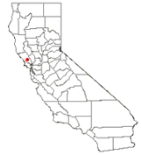
Penngrove is a census-designated place
(CDP) in Sonoma County
, California
, United States
, situated between the cities of Petaluma
and Cotati
, at the foot of Sonoma Mountain
. It is part of the North Bay
subregion of the San Francisco Bay Area
. The population was 2,522 at the 2010 census.
The site of a historic grove called Penn's Grove, it was formerly a freight station on the Northwestern Pacific Railroad
and a center of egg and chicken farming.
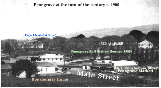
consists of Main Street, a 0.3 mile (0.482802 km) street linking Old Redwood Highway to Adobe Road. Penngrove School is located at the corner of Adobe Road, where Main Street becomes Petaluma Hill Road.
Lichau Creek
flows southward through the town, paralleling the railway. The creek feeds into the Petaluma River
, which flows to San Pablo Bay
.
Due to the Sonoma Mountain
's ancient volcanism, Penngrove is rich with obsidian
and petrified wood
. Its soil is unique, composed mainly of clay-like adobe
, which has been used for centuries as building material. A prime example of adobe architecture is the Rancho Petaluma Adobe
, a State Historic Park in nearby Petaluma.
Penngrove enjoys a mild Mediterranean climate.
According to the United States Census Bureau
, the CDP covers an area of 4.0 square miles (10.4 km²), all of it land.
was 626.7 people per square mile (242.0/km²). The racial makeup of Penngrove was 2,212 (87.7%) White, 19 (0.8%) African American, 24 (1.0%) Native American, 54 (2.1%) Asian, 2 (0.1%) Pacific Islander, 112 (4.4%) from other races
, and 99 (3.9%) from two or more races. Hispanic or Latino of any race were 292 persons (11.6%).
The Census reported that 99.6% of the population lived in households and 0.4% lived in non-institutionalized group quarters.
There were 1,040 households, out of which 260 (25.0%) had children under the age of 18 living in them, 483 (46.4%) were opposite-sex married couples
living together, 117 (11.3%) had a female householder with no husband present, 65 (6.3%) had a male householder with no wife present. There were 80 (7.7%) unmarried opposite-sex partnerships
, and 10 (1.0%) same-sex married couples or partnerships. 285 households (27.4%) were made up of individuals and 83 (8.0%) had someone living alone who was 65 years of age or older. The average household size was 2.42. There were 665 families
(63.9% of all households); the average family size was 2.89.
The population was spread out with 442 people (17.5%) under the age of 18, 244 people (9.7%) aged 18 to 24, 585 people (23.2%) aged 25 to 44, 889 people (35.2%) aged 45 to 64, and 362 people (14.4%) who were 65 years of age or older. The median age was 44.8 years. For every 100 females there were 98.4 males. For every 100 females age 18 and over, there were 99.0 males.
There were 1,120 housing units at an average density of 278.3 per square mile (107.5/km²), of which 61.5% were owner-occupied and 38.5% were occupied by renters. The homeowner vacancy rate was 1.4%; the rental vacancy rate was 3.1%. 64.6% of the population lived in owner-occupied housing units and 35.0% lived in rental housing units.
native people, the Mexican government granted Rancho Cotate to Captain Juan Castaneda in July 1844 for his military services in the region. The grant encompassed present-day Penngrove, Cotati
and Rohnert Park
. Cotate Rancho is a part of Vallejo Township which encompasses the plain between Sonoma Mountain and Petaluma Creek, San Pablo Bay
, with an east-west line dividing the tract from Santa Rosa
Township."
Rancho Cotate was sold in 1849 to Dr. Thomas S. Page, of Cotati, and eventually broken up and sold off piecemeal to incoming settlers.
The first European settlers in the Penngrove area were David Wharff, W.J. Hardin, and J.M. Palmer who arrived in 1852.
In October 1870, the San Francisco and North Pacific Railroad
completed the first railroad from Petaluma to Santa Rosa, running through Penngrove.
Ruth Anderson, the famous "Bell-Lady" of Penngrove (who lived on the site of the old schoolhouse on Oak Street), recalls,
"In the late 1860s, two brothers by the name of Penn came out from Pennsylvania and bought 80 acres (323,748.8 m²) of land in this area. They planted the area with olive trees, but when the trees matured it was found that the olives were not edible. The Penn brothers tore out many of the groves, sold the land and moved away. However, while they were here, they named their place Penn's Grove. Later it was changed to Penn grove, and still later, because our mail got confused with that of Pine Grove (the former name of Sebastopol
), the U.S. Postoffice Department changed the name to one word—Penngrove." (Harris 1980)
Other accounts state that there was another town with the name of Penn's Grove in New Jersey, which is why the Postoffice changed the name. Others claim that the Woodward family, who came from Pennsylvania, named their property Penn's Grove in honor of their home state.
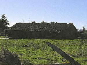 Along with the chicken and egg industry, Penngrove was a source of basalt paving stones, which were used to pave the streets of major cities in the Bay Area
, including San Francisco. Harris notes that 200 men were employed at the three major cobblestone quarries at the end of the 19th century, and that quarry scars can still be seen dotting the hills between East Railroad Ave. and Roberts Road. When the Northwestern Pacific Railroad was completed in 1870, the paving stone industry kept Penngrove station busy. After the turn of the century, Penngrove became the "second largest egg and poultry producing area in the country. Only Petaluma outdid this area" (Harris 1980). Apparently, and according to The San Francisco Examiner
, chickens paid better than gold mines. To this day, many dilapidated chicken houses dot old farms and country roads in the area.
, Boy Scouts of America
, 4-H
, and various other community organizations.
The first Post Office was located in the Edwards Building and was then moved into the Terribilini Building on the East side of Main Street. It was then moved next to Penngrove Market and a new structure for the Post Office was built in the 1980s on Main Street across from Penngrove Market.
and other surrounding communities.
Census-designated place
A census-designated place is a concentration of population identified by the United States Census Bureau for statistical purposes. CDPs are delineated for each decennial census as the statistical counterparts of incorporated places such as cities, towns and villages...
(CDP) in Sonoma County
Sonoma County, California
Sonoma County, located on the northern coast of the U.S. state of California, is the largest and northernmost of the nine San Francisco Bay Area counties. Its population at the 2010 census was 483,878. Its largest city and county seat is Santa Rosa....
, California
California
California is a state located on the West Coast of the United States. It is by far the most populous U.S. state, and the third-largest by land area...
, United States
United States
The United States of America is a federal constitutional republic comprising fifty states and a federal district...
, situated between the cities of Petaluma
Petaluma, California
Petaluma is a city in Sonoma County, California, in the United States. In the 2010 Census the population was 57,941.Located in Petaluma is the Rancho Petaluma Adobe, a National Historic Landmark. It was built beginning in 1836 by General Mariano Guadalupe Vallejo, then Commandant of the San...
and Cotati
Cotati, California
Cotati is an incorporated city in Sonoma County, California, U.S.A., located about north of San Francisco in the 101 corridor between Rohnert Park and Petaluma....
, at the foot of Sonoma Mountain
Sonoma Mountain
Sonoma Mountain is a prominent landform within the Sonoma Mountains of southern Sonoma County, California. At elevation of , Sonoma Mountain offers expansive views of the Pacific Ocean to the west and the Sonoma Valley to the east...
. It is part of the North Bay
North Bay (San Francisco Bay Area)
The North Bay is a subregion of the San Francisco Bay Area, in California, United States. The largest city is Santa Rosa. It is by far the least populous and least urbanized part of the Bay Area...
subregion of the San Francisco Bay Area
San Francisco Bay Area
The San Francisco Bay Area, commonly known as the Bay Area, is a populated region that surrounds the San Francisco and San Pablo estuaries in Northern California. The region encompasses metropolitan areas of San Francisco, Oakland, and San Jose, along with smaller urban and rural areas...
. The population was 2,522 at the 2010 census.
The site of a historic grove called Penn's Grove, it was formerly a freight station on the Northwestern Pacific Railroad
Northwestern Pacific Railroad
The Northwestern Pacific Railroad is a regional railroad serving California's North Coast. The railroad currently runs on 62 miles of the 462 mile main line, stretching from Schellville, California to Eureka, California...
and a center of egg and chicken farming.
Geography
Penngrove's downtownDowntown
Downtown is a term primarily used in North America by English speakers to refer to a city's core or central business district ....
consists of Main Street, a 0.3 mile (0.482802 km) street linking Old Redwood Highway to Adobe Road. Penngrove School is located at the corner of Adobe Road, where Main Street becomes Petaluma Hill Road.
Lichau Creek
Lichau Creek
Lichau Creek is an southwest-flowing stream in Sonoma County, California, United States which flows through the town of Penngrove and discharges into the Petaluma River....
flows southward through the town, paralleling the railway. The creek feeds into the Petaluma River
Petaluma River
The Petaluma River is a river in the California counties of Sonoma and Marin that becomes a tidal slough near its mouth. It springs from farmlands southwest of Cotati and flows generally southward through Petaluma's old town and of tidal marshes to end in northwest San Pablo Bay.-History:The word...
, which flows to San Pablo Bay
San Pablo Bay
San Pablo Bay is a tidal estuary that forms the northern extension of San Francisco Bay in northern California in the United States. Most of the Bay is shallow; however, there is a deep water channel approximately in mid bay, which allows access to Sacramento, Stockton, Benicia, Martinez, and...
.
Due to the Sonoma Mountain
Sonoma Mountain
Sonoma Mountain is a prominent landform within the Sonoma Mountains of southern Sonoma County, California. At elevation of , Sonoma Mountain offers expansive views of the Pacific Ocean to the west and the Sonoma Valley to the east...
's ancient volcanism, Penngrove is rich with obsidian
Obsidian
Obsidian is a naturally occurring volcanic glass formed as an extrusive igneous rock.It is produced when felsic lava extruded from a volcano cools rapidly with minimum crystal growth...
and petrified wood
Petrified wood
Petrified wood is the name given to a special type of fossilized remains of terrestrial vegetation. It is the result of a tree having turned completely into stone by the process of permineralization...
. Its soil is unique, composed mainly of clay-like adobe
Adobe
Adobe is a natural building material made from sand, clay, water, and some kind of fibrous or organic material , which the builders shape into bricks using frames and dry in the sun. Adobe buildings are similar to cob and mudbrick buildings. Adobe structures are extremely durable, and account for...
, which has been used for centuries as building material. A prime example of adobe architecture is the Rancho Petaluma Adobe
Rancho Petaluma Adobe
Rancho Petaluma Adobe is the name of a historic ranch house built from adobe bricks that was owned and constructed by General Mariano Guadalupe Vallejo, commandant of the Sonoma Pueblo from 1834 to 1857. It is the largest example of the Monterey Colonial style of architecture in the United States...
, a State Historic Park in nearby Petaluma.
Penngrove enjoys a mild Mediterranean climate.
According to the United States Census Bureau
United States Census Bureau
The United States Census Bureau is the government agency that is responsible for the United States Census. It also gathers other national demographic and economic data...
, the CDP covers an area of 4.0 square miles (10.4 km²), all of it land.
Demographics
The 2010 United States Census reported that Penngrove had a population of 2,522. The population densityPopulation density
Population density is a measurement of population per unit area or unit volume. It is frequently applied to living organisms, and particularly to humans...
was 626.7 people per square mile (242.0/km²). The racial makeup of Penngrove was 2,212 (87.7%) White, 19 (0.8%) African American, 24 (1.0%) Native American, 54 (2.1%) Asian, 2 (0.1%) Pacific Islander, 112 (4.4%) from other races
Race (United States Census)
Race and ethnicity in the United States Census, as defined by the Federal Office of Management and Budget and the United States Census Bureau, are self-identification data items in which residents choose the race or races with which they most closely identify, and indicate whether or not they are...
, and 99 (3.9%) from two or more races. Hispanic or Latino of any race were 292 persons (11.6%).
The Census reported that 99.6% of the population lived in households and 0.4% lived in non-institutionalized group quarters.
There were 1,040 households, out of which 260 (25.0%) had children under the age of 18 living in them, 483 (46.4%) were opposite-sex married couples
Marriage
Marriage is a social union or legal contract between people that creates kinship. It is an institution in which interpersonal relationships, usually intimate and sexual, are acknowledged in a variety of ways, depending on the culture or subculture in which it is found...
living together, 117 (11.3%) had a female householder with no husband present, 65 (6.3%) had a male householder with no wife present. There were 80 (7.7%) unmarried opposite-sex partnerships
POSSLQ
POSSLQ is an abbreviation for "Persons of Opposite Sex Sharing Living Quarters," a term coined in the late 1970s by the United States Census Bureau as part of an effort to more accurately gauge the prevalence of cohabitation in American households....
, and 10 (1.0%) same-sex married couples or partnerships. 285 households (27.4%) were made up of individuals and 83 (8.0%) had someone living alone who was 65 years of age or older. The average household size was 2.42. There were 665 families
Family (U.S. Census)
A family or family household is defined by the United States Census Bureau for statistical purposes as "a householder and one or more other people related to the householder by birth, marriage, or adoption. They do not include same-sex married couples even if the marriage was performed in a state...
(63.9% of all households); the average family size was 2.89.
The population was spread out with 442 people (17.5%) under the age of 18, 244 people (9.7%) aged 18 to 24, 585 people (23.2%) aged 25 to 44, 889 people (35.2%) aged 45 to 64, and 362 people (14.4%) who were 65 years of age or older. The median age was 44.8 years. For every 100 females there were 98.4 males. For every 100 females age 18 and over, there were 99.0 males.
There were 1,120 housing units at an average density of 278.3 per square mile (107.5/km²), of which 61.5% were owner-occupied and 38.5% were occupied by renters. The homeowner vacancy rate was 1.4%; the rental vacancy rate was 3.1%. 64.6% of the population lived in owner-occupied housing units and 35.0% lived in rental housing units.
History
Originally home of the Coast MiwokCoast Miwok
The Coast Miwok were the second largest group of Miwok Native American people. The Coast Miwok inhabited the general area of modern Marin County and southern Sonoma County in Northern California, from the Golden Gate north to Duncans Point and eastward to Sonoma Creek...
native people, the Mexican government granted Rancho Cotate to Captain Juan Castaneda in July 1844 for his military services in the region. The grant encompassed present-day Penngrove, Cotati
Cotati, California
Cotati is an incorporated city in Sonoma County, California, U.S.A., located about north of San Francisco in the 101 corridor between Rohnert Park and Petaluma....
and Rohnert Park
Rohnert Park, California
Rohnert Park is a city in Sonoma County, California, United States, located approximately north of San Francisco. The population at the 2010 United States Census was 40,971. It is an early planned city, modeled directly after Levittown, New York and Levittown, Pennsylvania. Rohnert Park is the...
. Cotate Rancho is a part of Vallejo Township which encompasses the plain between Sonoma Mountain and Petaluma Creek, San Pablo Bay
San Pablo Bay
San Pablo Bay is a tidal estuary that forms the northern extension of San Francisco Bay in northern California in the United States. Most of the Bay is shallow; however, there is a deep water channel approximately in mid bay, which allows access to Sacramento, Stockton, Benicia, Martinez, and...
, with an east-west line dividing the tract from Santa Rosa
Santa Rosa, California
Santa Rosa is the county seat of Sonoma County, California, United States. The 2010 census reported a population of 167,815. Santa Rosa is the largest city in California's Wine Country and fifth largest city in the San Francisco Bay Area, after San Jose, San Francisco, Oakland, and Fremont and 26th...
Township."
Rancho Cotate was sold in 1849 to Dr. Thomas S. Page, of Cotati, and eventually broken up and sold off piecemeal to incoming settlers.
The first European settlers in the Penngrove area were David Wharff, W.J. Hardin, and J.M. Palmer who arrived in 1852.
In October 1870, the San Francisco and North Pacific Railroad
Northwestern Pacific Railroad
The Northwestern Pacific Railroad is a regional railroad serving California's North Coast. The railroad currently runs on 62 miles of the 462 mile main line, stretching from Schellville, California to Eureka, California...
completed the first railroad from Petaluma to Santa Rosa, running through Penngrove.
Culture
Every summer on the Sunday closest to July 4, Penngrove celebrates the 4th of July with a parade sponsored by the Penngrove Social Fireman. On Saturday at the Penngrove Fire Station, located at the corner of Main Street and Old Redwood Highway, the Rancho Adobe Firefighters Association sponsors a breakfast.Name
The naming of Penngrove is uncertain; there are three main "histories" of the name's origin.Ruth Anderson, the famous "Bell-Lady" of Penngrove (who lived on the site of the old schoolhouse on Oak Street), recalls,
"In the late 1860s, two brothers by the name of Penn came out from Pennsylvania and bought 80 acres (323,748.8 m²) of land in this area. They planted the area with olive trees, but when the trees matured it was found that the olives were not edible. The Penn brothers tore out many of the groves, sold the land and moved away. However, while they were here, they named their place Penn's Grove. Later it was changed to Penn grove, and still later, because our mail got confused with that of Pine Grove (the former name of Sebastopol
Sebastopol, California
Sebastopol is a city in Sonoma County, California, United States, approximately north of San Francisco. The population was 7,379 at the 2010 census, but its businesses also serve surrounding rural portions of Sonoma County, totaling about 50,000 people...
), the U.S. Postoffice Department changed the name to one word—Penngrove." (Harris 1980)
Other accounts state that there was another town with the name of Penn's Grove in New Jersey, which is why the Postoffice changed the name. Others claim that the Woodward family, who came from Pennsylvania, named their property Penn's Grove in honor of their home state.
Community development
San Francisco Bay Area
The San Francisco Bay Area, commonly known as the Bay Area, is a populated region that surrounds the San Francisco and San Pablo estuaries in Northern California. The region encompasses metropolitan areas of San Francisco, Oakland, and San Jose, along with smaller urban and rural areas...
, including San Francisco. Harris notes that 200 men were employed at the three major cobblestone quarries at the end of the 19th century, and that quarry scars can still be seen dotting the hills between East Railroad Ave. and Roberts Road. When the Northwestern Pacific Railroad was completed in 1870, the paving stone industry kept Penngrove station busy. After the turn of the century, Penngrove became the "second largest egg and poultry producing area in the country. Only Petaluma outdid this area" (Harris 1980). Apparently, and according to The San Francisco Examiner
The San Francisco Examiner
The San Francisco Examiner is a U.S. daily newspaper. It has been published continuously in San Francisco, California, since the late 19th century.-19th century:...
, chickens paid better than gold mines. To this day, many dilapidated chicken houses dot old farms and country roads in the area.
Penngrove Community Church
One of the oldest buildings in Penngrove, the old Methodist Episcopal Church was built in 1898 at the corner of Formschlag Lane and Petaluma Hill Road. In 1910, the church was moved on wooden rollers to its present location at 9970 Oak Street. The original building now serves as a fellowship hall, while a newer structure, built in 1955-7, now serves as the main sanctuary. The original structure is still used by Girl Scouts of the USAGirl Scouts of the USA
The Girl Scouts of the United States of America is a youth organization for girls in the United States and American girls living abroad. It describes itself as "the world's preeminent organization dedicated solely to girls". It was founded by Juliette Gordon Low in 1912 and was organized after Low...
, Boy Scouts of America
Boy Scouts of America
The Boy Scouts of America is one of the largest youth organizations in the United States, with over 4.5 million youth members in its age-related divisions...
, 4-H
4-H
4-H in the United States is a youth organization administered by the National Institute of Food and Agriculture of the United States Department of Agriculture , with the mission of "engaging youth to reach their fullest potential while advancing the field of youth development." The name represents...
, and various other community organizations.
Penngrove School
The first classes were taught in a small building on Peters' Ranch (Harris 1980: 33). In 1876, the first school was built at the southwest corner of Adobe Road and Main Street. It was named the Eagle School after the Eagle Hotel located across Main Street and shown on Thompson's map of Sonoma County (1877). In 1906 after construction of the second Eagle School, the old school was used as a teacher's residence. It was later moved about 50 ft (15.2 m) south to its current location and reconfigured into an ell. The second Eagle School was built between Main and Oak streets. The original structure no longer exists, and a private home now stands on that property, however, the steps leading to "Eagle School" from Main Street are still visible. Some of building materials were recycled for construction of the Community Center and a small building in Penngrove Park. In 1926 a beautiful mission-style school house was built and named Penngrove School, Eagle District. Penngrove School joined the Petaluma City School District in 1962. In 1963, the present Multi-purpose room was constructed and newer wings were developed between it and the older portion of the school. The Multi-purpose room was expanded with a stage in 2006. The 1926 school building is now primarily used for offices and the school library.Post Office
"The Post Office at Penn's Grove was established on October 30, 1882. A series of name changes occurred because of mail mix-ups with Penn's Grove, New Jersey and Pine Grove (later renamed Sebastopol). In May 1895 the Petaluma paper reported: 'The Penngrove Post Office has had its name changed again and is now officially known by its former and best known title, Penn's Grove.' In 1908 the name was changed back to Penngrove and has remained so since" (Harris 1980).The first Post Office was located in the Edwards Building and was then moved into the Terribilini Building on the East side of Main Street. It was then moved next to Penngrove Market and a new structure for the Post Office was built in the 1980s on Main Street across from Penngrove Market.
Fire Department
At the turn of the century, three fire chemical carts served as Penngrove's fire protection. The foundation of Firehouse #1 can be found between Penngrove Church and the Old Eagle School lot on Oak Street. "The fire department was established in the fall of 1928. In 1929 the first fire engine was put into service" (Harris 1980). In 1938, the art deco fire house was built on Woodward Avenue, just above Main Street. This structure still bears the title "Penngrove Firehouse." It is a now a private residence. In 1975, the current firehouse was built at the corner of Old Redwood Highway and Main Street, the unofficial entrance to Penngrove. Until the 1990s, a siren placed at the top of the building would sound in order to alert volunteer firefighters of a fire. The siren had over a 1.5 miles (2.4 km) radius and could be heard frequently through the hot, dry summer months. This system was replaced by pagers in the 1990s, but the siren is still perched on top of the firehouse. Currently, the Penngrove Firehouse is part of the Rancho-Adobe Fire District, along with CotatiCotati, California
Cotati is an incorporated city in Sonoma County, California, U.S.A., located about north of San Francisco in the 101 corridor between Rohnert Park and Petaluma....
and other surrounding communities.