

San Ardo Oil Field
Encyclopedia
The San Ardo Oil Field is a large oil field
in Monterey County, California
, in the United States. It is in the upper Salinas Valley
, about five miles (8 km) south of the small town of San Ardo
, and about twenty miles (32 km) north of Paso Robles
. With an estimated ultimate recovery of 530000000 barrels (84,263,266.4 m³) of oil, it is the 13th-largest oil field in California, and of the top twenty California oil fields in size, it is the most recent to be discovered (1947). As of the end of 2006, the principal operators of the field were Chevron Corp. and Aera Energy LLC
.
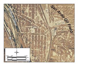
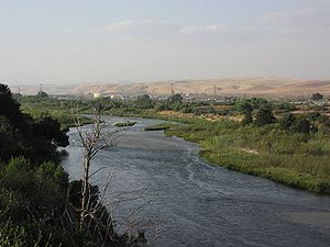 A familiar sight to travelers on U.S. Highway 101 between Los Angeles and San Francisco, the oil field is located about midway between Paso Robles and King City
, in the southern part of Monterey County, at the Alvarado Road exit from U.S. 101. Most of the field is on the east bank of the Salinas River
and in the adjacent hills of the Coast Ranges. Overall it is about five miles (8 km) long by two wide, and its productive area encompasses 4390 acres (17.8 km²). Elevations on the oil field range from approximately 430 feet (131.1 m) at the Salinas River to around 1100 feet (335.3 m) in the hills to the east; the densest area of operations is on the flat land in the river valley.
Vegetation in the oil field area varies from riparian in the immediate vicinity of the Salinas River, to grassland, chaparral, and oak woodland in the hills and uplands, although much of the vegetation has been removed in the central area of active operations. Land immediately north of the oil field in the Salinas River Valley is agricultural, while other adjacent land, which is mostly hilly, is predominantly used for livestock grazing.
in California; most of the other large fields are east of the fault. As is common with California oil fields, the San Ardo Field is an anticlinal
structure. The productive units are the Aurignac Sands, which are a portion of the huge Monterey Formation
, a sedimentary rock unit which underlies much of coastal California. These sands are an average of about 700 feet (213.4 m) thick, contain an abundance of heavy crude oil, and overlie granodioritic
basement rocks. Above the Aurignac sands are the thinner but also productive Lombardi sands, which can be found at about 1800 feet (548.6 m) below ground surface. The granodioritic basement is generally around 2500 feet (762 m) below ground surface.
Rock formations above the highest productive unit include the Paso Robles, Pancho Rita, and Santa Margarita Formations, of Pleistocene
, Pliocene
, and Miocene
age, respectively. All of the productive units are of Miocene age, and the underlying basement rocks date to the Jurassic
period. The Los Lobos thrust fault complex demarcates the western boundary of the field.
 The Texas Company (later Texaco, and currently Chevron Corp.) discovered the field in November 1947 by drilling their "Lombardi 1" well to a depth of 2158 feet (657.8 m). Initial production from the discovery well was 155 oilbbl/d.
Since the oil is heavy crude, with API gravity
of only 9-11 in the Lombardi Sands and 13 in the Aurignac, getting it to flow to production wells can be difficult. Various enhanced recovery technologies developed during the 1960s and 1970s have made the process easier. Steam flooding is the technology of choice in the San Ardo Field; injection wells force steam into the ground to heat up the crude and decrease its viscosity
, and if strategically placed, can push the oil to nearby production wells. Steam flooding has been used in both the Aurignac and Lombardi sands since 1966-1967; water flooding is also being used in the Aurignac. The peak production from the field was in 1967, the first year in which both productive units were subject to steam flooding. Fireflooding, a technology in which the oil is ignited by an electric coil in the presence of oxygen, with the combustion front moving towards a production well, and sometimes followed by water flooding as a further assist, has also been used in several of the San Ardo pools.
Currently, the principal operators on the field are Chevron Corp. and Aera Energy LLC
. Two smaller operators are active on the field as of 2010: NY Oil Company Inc., and Salinas Energy Corp. As of the end of 2008 Chevron and Aera Energy were the two largest producers of oil in California.
Oil field
An oil field is a region with an abundance of oil wells extracting petroleum from below ground. Because the oil reservoirs typically extend over a large area, possibly several hundred kilometres across, full exploitation entails multiple wells scattered across the area...
in Monterey County, California
Monterey County, California
Monterey County is a county located on the Pacific coast of the U.S. state of California, its northwestern section forming the southern half of Monterey Bay. The northern half of the bay is in Santa Cruz County. As of 2010, the population was 415,057. The county seat and largest city is Salinas...
, in the United States. It is in the upper Salinas Valley
Salinas Valley
The Salinas Valley lies south of San Francisco, California.The word "salina" is spanish for salt marsh, salt lake or salt pan.-Geography:The Salinas Valley runs approximately south-east from Salinas towards King City. The valley lends its name to the geologic province in which it's located, the...
, about five miles (8 km) south of the small town of San Ardo
San Ardo, California
San Ardo is a census-designated place in Monterey County, California, United States. San Ardo is located southeast of King City, at an elevation of 449 feet...
, and about twenty miles (32 km) north of Paso Robles
Paso Robles, California
Paso Robles is a city in San Luis Obispo County, California, United States. Paso Robles is the fastest growing city in San Luis Obispo County: Its population at the 2000 census was 24,297; in 2010 it recorded some 29,793 residentsLocated on the Salinas River north of San Luis Obispo, California,...
. With an estimated ultimate recovery of 530000000 barrels (84,263,266.4 m³) of oil, it is the 13th-largest oil field in California, and of the top twenty California oil fields in size, it is the most recent to be discovered (1947). As of the end of 2006, the principal operators of the field were Chevron Corp. and Aera Energy LLC
Aera Energy LLC
Aera Energy LLC is a natural gas, oil exploration and production company jointly owned by Shell and ExxonMobil headquartered in Bakersfield, California...
.
Setting
King City, California
King City is a city in Monterey County, California, United States. King City is located on the Salinas River southeast of Salinas, at an elevation of 335 feet . It lies along U.S. Route 101 in the Salinas Valley of the Central Coast of California. King City is a member of the Association of...
, in the southern part of Monterey County, at the Alvarado Road exit from U.S. 101. Most of the field is on the east bank of the Salinas River
Salinas River (California)
The Salinas River is the largest river of the central coast of California, running and draining 4,160 square miles. It flows north-northwest and drains the Salinas Valley that slices through the Coast Range south from Monterey Bay...
and in the adjacent hills of the Coast Ranges. Overall it is about five miles (8 km) long by two wide, and its productive area encompasses 4390 acres (17.8 km²). Elevations on the oil field range from approximately 430 feet (131.1 m) at the Salinas River to around 1100 feet (335.3 m) in the hills to the east; the densest area of operations is on the flat land in the river valley.
Vegetation in the oil field area varies from riparian in the immediate vicinity of the Salinas River, to grassland, chaparral, and oak woodland in the hills and uplands, although much of the vegetation has been removed in the central area of active operations. Land immediately north of the oil field in the Salinas River Valley is agricultural, while other adjacent land, which is mostly hilly, is predominantly used for livestock grazing.
Geology
The San Ardo Oil Field is the farthest north of the major oil fields west of the San Andreas FaultSan Andreas Fault
The San Andreas Fault is a continental strike-slip fault that runs a length of roughly through California in the United States. The fault's motion is right-lateral strike-slip...
in California; most of the other large fields are east of the fault. As is common with California oil fields, the San Ardo Field is an anticlinal
Anticline
In structural geology, an anticline is a fold that is convex up and has its oldest beds at its core. The term is not to be confused with antiform, which is a purely descriptive term for any fold that is convex up. Therefore if age relationships In structural geology, an anticline is a fold that is...
structure. The productive units are the Aurignac Sands, which are a portion of the huge Monterey Formation
Monterey Formation
The Monterey Formation is an extensive Miocene oil-rich geological sedimentary formation in California, with massive outcroppings of the formation in areas of the California Coast Ranges, Peninsular Ranges, and on some of California's off-shore islands...
, a sedimentary rock unit which underlies much of coastal California. These sands are an average of about 700 feet (213.4 m) thick, contain an abundance of heavy crude oil, and overlie granodioritic
Granodiorite
Granodiorite is an intrusive igneous rock similar to granite, but containing more plagioclase than orthoclase-type feldspar. Officially, it is defined as a phaneritic igneous rock with greater than 20% quartz by volume where at least 65% of the feldspar is plagioclase. It usually contains abundant...
basement rocks. Above the Aurignac sands are the thinner but also productive Lombardi sands, which can be found at about 1800 feet (548.6 m) below ground surface. The granodioritic basement is generally around 2500 feet (762 m) below ground surface.
Rock formations above the highest productive unit include the Paso Robles, Pancho Rita, and Santa Margarita Formations, of Pleistocene
Pleistocene
The Pleistocene is the epoch from 2,588,000 to 11,700 years BP that spans the world's recent period of repeated glaciations. The name pleistocene is derived from the Greek and ....
, Pliocene
Pliocene
The Pliocene Epoch is the period in the geologic timescale that extends from 5.332 million to 2.588 million years before present. It is the second and youngest epoch of the Neogene Period in the Cenozoic Era. The Pliocene follows the Miocene Epoch and is followed by the Pleistocene Epoch...
, and Miocene
Miocene
The Miocene is a geological epoch of the Neogene Period and extends from about . The Miocene was named by Sir Charles Lyell. Its name comes from the Greek words and and means "less recent" because it has 18% fewer modern sea invertebrates than the Pliocene. The Miocene follows the Oligocene...
age, respectively. All of the productive units are of Miocene age, and the underlying basement rocks date to the Jurassic
Jurassic
The Jurassic is a geologic period and system that extends from about Mya to Mya, that is, from the end of the Triassic to the beginning of the Cretaceous. The Jurassic constitutes the middle period of the Mesozoic era, also known as the age of reptiles. The start of the period is marked by...
period. The Los Lobos thrust fault complex demarcates the western boundary of the field.
Production and operations
Since the oil is heavy crude, with API gravity
API gravity
The American Petroleum Institute gravity, or API gravity, is a measure of how heavy or light a petroleum liquid is compared to water. If its API gravity is greater than 10, it is lighter and floats on water; if less than 10, it is heavier and sinks...
of only 9-11 in the Lombardi Sands and 13 in the Aurignac, getting it to flow to production wells can be difficult. Various enhanced recovery technologies developed during the 1960s and 1970s have made the process easier. Steam flooding is the technology of choice in the San Ardo Field; injection wells force steam into the ground to heat up the crude and decrease its viscosity
Viscosity
Viscosity is a measure of the resistance of a fluid which is being deformed by either shear or tensile stress. In everyday terms , viscosity is "thickness" or "internal friction". Thus, water is "thin", having a lower viscosity, while honey is "thick", having a higher viscosity...
, and if strategically placed, can push the oil to nearby production wells. Steam flooding has been used in both the Aurignac and Lombardi sands since 1966-1967; water flooding is also being used in the Aurignac. The peak production from the field was in 1967, the first year in which both productive units were subject to steam flooding. Fireflooding, a technology in which the oil is ignited by an electric coil in the presence of oxygen, with the combustion front moving towards a production well, and sometimes followed by water flooding as a further assist, has also been used in several of the San Ardo pools.
Currently, the principal operators on the field are Chevron Corp. and Aera Energy LLC
Aera Energy LLC
Aera Energy LLC is a natural gas, oil exploration and production company jointly owned by Shell and ExxonMobil headquartered in Bakersfield, California...
. Two smaller operators are active on the field as of 2010: NY Oil Company Inc., and Salinas Energy Corp. As of the end of 2008 Chevron and Aera Energy were the two largest producers of oil in California.