
Summerland, California
Encyclopedia
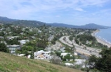
Summerland is a census-designated place
(CDP) in Santa Barbara County
, California
, United States
. The population was 1,448 at the 2010 census, down from 1,545 at the 2000 census.
The town includes a school and a Presbyterian Church. There are many small businesses.
, who used it as waterproofing for the roof. In 1883, spiritualist
and real estate speculator H.L. Williams founded the town of Summerland. He named it as an advertisement for the excellent weather, and in 1888 divided his land tract, on a moderately sloping hill facing the ocean, into numerous parcels. He promoted the tiny lots – 25 x 60 – to fellow spiritualists, who bought them in quantity and moved to the area. The houses they built included bizarre architectural features such as doors which opened to walls, and stairways ascending to nowhere. The spiritual center of the town was a community séance
room, demolished only when Highway 101 was put through in the 1950s.
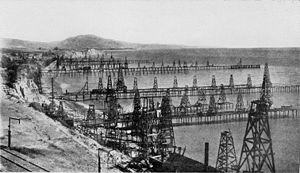 In the 1890s, oil development began in the coastal area of Summerland, at the Summerland Oil Field
. Numerous wooden oil derricks were built on the beach, and on piers stretching into the ocean. The world's first offshore oil well, drilled into the sea floor, was at this location. Production at this beach area peaked before 1910, although most of the rigs remained into the 1920s. Peak production from the onshore portion of the Summerland Field did not actually occur until 1930; the last oil was pumped from the nearshore region in 1940. In 1957, Standard Oil Co. of California (now Chevron) found the large Summerland Offshore Oil Field, several miles offshore, which was shut down in the 1990s.
In January 1969, a blowout at the Dos Cuadras Field
, about five miles offshore, caused the Santa Barbara Oil Spill
, a formative event for the modern environmental movement.
and west-northwest of the city of Carpinteria
, and is almost entirely surrounded by the unincorporated community of Montecito
. Summerland has a significantly higher population density than the surrounding area. U.S. Route 101
goes through Summerland.
According to the United States Census Bureau
, the CDP has a total area of 2.0 square miles (5.2 km²), of which, 2.0 square miles (5.1 km²) of it is land and 0.33% is water.
was 727.9 people per square mile (281.1/km²). The racial makeup of Summerland was 1,295 (89.4%) White, 3 (0.2%) African American, 7 (0.5%) Native American, 41 (2.8%) Asian, 6 (0.4%) Pacific Islander, 51 (3.5%) from other races
, and 45 (3.1%) from two or more races. Hispanic or Latino of any race were 192 persons (13.3%).
The Census reported that 1,448 people (100% of the population) lived in households, 0 (0%) lived in non-institutionalized group quarters, and 0 (0%) were institutionalized.
There were 687 households, out of which 128 (18.6%) had children under the age of 18 living in them, 270 (39.3%) were opposite-sex married couples
living together, 55 (8.0%) had a female householder with no husband present, 23 (3.3%) had a male householder with no wife present. There were 54 (7.9%) unmarried opposite-sex partnerships
, and 9 (1.3%) same-sex married couples or partnerships. 230 households (33.5%) were made up of individuals and 62 (9.0%) had someone living alone who was 65 years of age or older. The average household size was 2.11. There were 348 families
(50.7% of all households); the average family size was 2.68.
The population was spread out with 211 people (14.6%) under the age of 18, 119 people (8.2%) aged 18 to 24, 315 people (21.8%) aged 25 to 44, 546 people (37.7%) aged 45 to 64, and 257 people (17.7%) who were 65 years of age or older. The median age was 49.2 years. For every 100 females there were 92.0 males. For every 100 females age 18 and over, there were 88.6 males.
There were 823 housing units at an average density of 413.7 per square mile (159.7/km²), of which 362 (52.7%) were owner-occupied, and 325 (47.3%) were occupied by renters. The homeowner vacancy rate was 3.2%; the rental vacancy rate was 9.7%. 790 people (54.6% of the population) lived in owner-occupied housing units and 658 people (45.4%) lived in rental housing units.
of 2000, there were 1,545 people, 715 households, and 368 families residing in the CDP. The population density
was 764.7 people per square mile (295.3/km²). There were 784 housing units at an average density of 388.0 per square mile (149.9/km²). The racial makeup of the CDP was 91.78% White, 0.45% African American, 0.26% Native American, 2.39% Asian, 0.13% Pacific Islander, 2.27% from other races
, and 2.72% from two or more races. Hispanic or Latino of any race were 7.44% of the population.
There were 715 households out of which 17.9% had children under the age of 18 living with them, 42.2% were married couples
living together, 7.4% had a female householder with no husband present, and 48.5% were non-families. 33.1% of all households were made up of individuals and 5.5% had someone living alone who was 65 years of age or older. The average household size was 2.16 and the average family size was 2.70.
In the CDP the population was spread out with 14.6% under the age of 18, 6.7% from 18 to 24, 34.2% from 25 to 44, 32.9% from 45 to 64, and 11.7% who were 65 years of age or older. The median age was 42 years. For every 100 females there were 93.9 males. For every 100 females age 18 and over, there were 91.9 males.
The median income for a household in the CDP was $53,964, and the median income for a family was $75,625. Males had a median income of $50,469 versus $41,042 for females. The per capita income
for the CDP was $41,668. About 4.5% of families and 9.5% of the population were below the poverty line, including 7.5% of those under age 18 and none of those age 65 or over.
Census-designated place
A census-designated place is a concentration of population identified by the United States Census Bureau for statistical purposes. CDPs are delineated for each decennial census as the statistical counterparts of incorporated places such as cities, towns and villages...
(CDP) in Santa Barbara County
Santa Barbara County, California
Santa Barbara County is a county located in the southern portion of the U.S. state of California, on the Pacific coast. As of 2010 the county had a population of 423,895. The county seat is Santa Barbara and the largest city is Santa Maria.-History:...
, California
California
California is a state located on the West Coast of the United States. It is by far the most populous U.S. state, and the third-largest by land area...
, United States
United States
The United States of America is a federal constitutional republic comprising fifty states and a federal district...
. The population was 1,448 at the 2010 census, down from 1,545 at the 2000 census.
The town includes a school and a Presbyterian Church. There are many small businesses.
History
Tar from natural oil seeps in the Summerland area was long used as a sealant, both by the native Chumash peoples and by the Spanish builders of the Mission Santa BarbaraMission Santa Barbara
In 1840, Alta California and Baja California were removed from the Diocese of Sonora to form the Diocese of Both Californias. Bishop Francisco Garcia Diego y Moreno, OFM, established his cathedra at Mission Santa Barbara, making the chapel the pro-cathedral of the diocese until 1849...
, who used it as waterproofing for the roof. In 1883, spiritualist
Spiritualism
Spiritualism is a belief system or religion, postulating the belief that spirits of the dead residing in the spirit world have both the ability and the inclination to communicate with the living...
and real estate speculator H.L. Williams founded the town of Summerland. He named it as an advertisement for the excellent weather, and in 1888 divided his land tract, on a moderately sloping hill facing the ocean, into numerous parcels. He promoted the tiny lots – 25 x 60 – to fellow spiritualists, who bought them in quantity and moved to the area. The houses they built included bizarre architectural features such as doors which opened to walls, and stairways ascending to nowhere. The spiritual center of the town was a community séance
Séance
A séance is an attempt to communicate with spirits. The word "séance" comes from the French word for "seat," "session" or "sitting," from the Old French "seoir," "to sit." In French, the word's meaning is quite general: one may, for example, speak of "une séance de cinéma"...
room, demolished only when Highway 101 was put through in the 1950s.
Summerland Oil Field
The Summerland Oil Field is an inactive oil field in Santa Barbara County, California, about four miles east of the city of Santa Barbara, within and next to the unincorporated community of Summerland...
. Numerous wooden oil derricks were built on the beach, and on piers stretching into the ocean. The world's first offshore oil well, drilled into the sea floor, was at this location. Production at this beach area peaked before 1910, although most of the rigs remained into the 1920s. Peak production from the onshore portion of the Summerland Field did not actually occur until 1930; the last oil was pumped from the nearshore region in 1940. In 1957, Standard Oil Co. of California (now Chevron) found the large Summerland Offshore Oil Field, several miles offshore, which was shut down in the 1990s.
In January 1969, a blowout at the Dos Cuadras Field
Dos Cuadras Offshore Oil Field
The Dos Cuadras Offshore Oil Field is a large oil and gas field underneath the Santa Barbara Channel about eight miles southeast of Santa Barbara, California. Discovered in 1968, and with a cumulative production of over 260 million barrels of oil, it is the 24th-largest oil field within California...
, about five miles offshore, caused the Santa Barbara Oil Spill
1969 Santa Barbara oil spill
The Santa Barbara oil spill occurred in January and February 1969 in the Santa Barbara Channel, near the city of Santa Barbara in Southern California. It was the largest oil spill in United States waters at the time, and now ranks third after the 2010 Deepwater Horizon and 1989 Exxon Valdez spills...
, a formative event for the modern environmental movement.
Geography
Summerland is located at 34°25′17"N 119°35′45"W (34.421395, -119.595969). It is on the coast directly east of the city of Santa BarbaraSanta Barbara, California
Santa Barbara is the county seat of Santa Barbara County, California, United States. Situated on an east-west trending section of coastline, the longest such section on the West Coast of the United States, the city lies between the steeply-rising Santa Ynez Mountains and the Pacific Ocean...
and west-northwest of the city of Carpinteria
Carpinteria, California
Carpinteria is a small oceanside city located in southeastern Santa Barbara County, California, east of Santa Barbara and northwest of Ventura. The population was 13,040 at the 2010 census, down from 14,194 at the 2000 census....
, and is almost entirely surrounded by the unincorporated community of Montecito
Montecito, California
Montecito is an unincorporated community in Santa Barbara County, California. As a census-designated place, it had a population of 8,965 in 2010. This does not include areas such as Coast Village Road, that, while usually considered part of Montecito, are actually within the city limits of Santa...
. Summerland has a significantly higher population density than the surrounding area. U.S. Route 101
U.S. Route 101
U.S. Route 101, or U.S. Highway 101, is an important north–south U.S. highway that runs through the states of California, Oregon, and Washington, on the West Coast of the United States...
goes through Summerland.
According to the United States Census Bureau
United States Census Bureau
The United States Census Bureau is the government agency that is responsible for the United States Census. It also gathers other national demographic and economic data...
, the CDP has a total area of 2.0 square miles (5.2 km²), of which, 2.0 square miles (5.1 km²) of it is land and 0.33% is water.
2010
The 2010 United States Census reported that Summerland had a population of 1,448. The population densityPopulation density
Population density is a measurement of population per unit area or unit volume. It is frequently applied to living organisms, and particularly to humans...
was 727.9 people per square mile (281.1/km²). The racial makeup of Summerland was 1,295 (89.4%) White, 3 (0.2%) African American, 7 (0.5%) Native American, 41 (2.8%) Asian, 6 (0.4%) Pacific Islander, 51 (3.5%) from other races
Race (United States Census)
Race and ethnicity in the United States Census, as defined by the Federal Office of Management and Budget and the United States Census Bureau, are self-identification data items in which residents choose the race or races with which they most closely identify, and indicate whether or not they are...
, and 45 (3.1%) from two or more races. Hispanic or Latino of any race were 192 persons (13.3%).
The Census reported that 1,448 people (100% of the population) lived in households, 0 (0%) lived in non-institutionalized group quarters, and 0 (0%) were institutionalized.
There were 687 households, out of which 128 (18.6%) had children under the age of 18 living in them, 270 (39.3%) were opposite-sex married couples
Marriage
Marriage is a social union or legal contract between people that creates kinship. It is an institution in which interpersonal relationships, usually intimate and sexual, are acknowledged in a variety of ways, depending on the culture or subculture in which it is found...
living together, 55 (8.0%) had a female householder with no husband present, 23 (3.3%) had a male householder with no wife present. There were 54 (7.9%) unmarried opposite-sex partnerships
POSSLQ
POSSLQ is an abbreviation for "Persons of Opposite Sex Sharing Living Quarters," a term coined in the late 1970s by the United States Census Bureau as part of an effort to more accurately gauge the prevalence of cohabitation in American households....
, and 9 (1.3%) same-sex married couples or partnerships. 230 households (33.5%) were made up of individuals and 62 (9.0%) had someone living alone who was 65 years of age or older. The average household size was 2.11. There were 348 families
Family (U.S. Census)
A family or family household is defined by the United States Census Bureau for statistical purposes as "a householder and one or more other people related to the householder by birth, marriage, or adoption. They do not include same-sex married couples even if the marriage was performed in a state...
(50.7% of all households); the average family size was 2.68.
The population was spread out with 211 people (14.6%) under the age of 18, 119 people (8.2%) aged 18 to 24, 315 people (21.8%) aged 25 to 44, 546 people (37.7%) aged 45 to 64, and 257 people (17.7%) who were 65 years of age or older. The median age was 49.2 years. For every 100 females there were 92.0 males. For every 100 females age 18 and over, there were 88.6 males.
There were 823 housing units at an average density of 413.7 per square mile (159.7/km²), of which 362 (52.7%) were owner-occupied, and 325 (47.3%) were occupied by renters. The homeowner vacancy rate was 3.2%; the rental vacancy rate was 9.7%. 790 people (54.6% of the population) lived in owner-occupied housing units and 658 people (45.4%) lived in rental housing units.
2000
As of the censusCensus
A census is the procedure of systematically acquiring and recording information about the members of a given population. It is a regularly occurring and official count of a particular population. The term is used mostly in connection with national population and housing censuses; other common...
of 2000, there were 1,545 people, 715 households, and 368 families residing in the CDP. The population density
Population density
Population density is a measurement of population per unit area or unit volume. It is frequently applied to living organisms, and particularly to humans...
was 764.7 people per square mile (295.3/km²). There were 784 housing units at an average density of 388.0 per square mile (149.9/km²). The racial makeup of the CDP was 91.78% White, 0.45% African American, 0.26% Native American, 2.39% Asian, 0.13% Pacific Islander, 2.27% from other races
Race (United States Census)
Race and ethnicity in the United States Census, as defined by the Federal Office of Management and Budget and the United States Census Bureau, are self-identification data items in which residents choose the race or races with which they most closely identify, and indicate whether or not they are...
, and 2.72% from two or more races. Hispanic or Latino of any race were 7.44% of the population.
There were 715 households out of which 17.9% had children under the age of 18 living with them, 42.2% were married couples
Marriage
Marriage is a social union or legal contract between people that creates kinship. It is an institution in which interpersonal relationships, usually intimate and sexual, are acknowledged in a variety of ways, depending on the culture or subculture in which it is found...
living together, 7.4% had a female householder with no husband present, and 48.5% were non-families. 33.1% of all households were made up of individuals and 5.5% had someone living alone who was 65 years of age or older. The average household size was 2.16 and the average family size was 2.70.
In the CDP the population was spread out with 14.6% under the age of 18, 6.7% from 18 to 24, 34.2% from 25 to 44, 32.9% from 45 to 64, and 11.7% who were 65 years of age or older. The median age was 42 years. For every 100 females there were 93.9 males. For every 100 females age 18 and over, there were 91.9 males.
The median income for a household in the CDP was $53,964, and the median income for a family was $75,625. Males had a median income of $50,469 versus $41,042 for females. The per capita income
Per capita income
Per capita income or income per person is a measure of mean income within an economic aggregate, such as a country or city. It is calculated by taking a measure of all sources of income in the aggregate and dividing it by the total population...
for the CDP was $41,668. About 4.5% of families and 9.5% of the population were below the poverty line, including 7.5% of those under age 18 and none of those age 65 or over.
In popular culture
- Is mentioned in the EverclearEverclear (band)Everclear is a rock band formed in Portland, Oregon in 1992 best known for their radio hits spanning more than a decade. For most of its existence, Everclear has consisted of Art Alexakis , Craig Montoya , and Greg Eklund . Eklund replaced original drummer Scott Cuthbert in 1994...
song "Summerland", from their Sparkle and FadeSparkle and FadeSparkle and Fade is the second album by Everclear, released on May 23, 1995. It was their first album to be released exclusively on Capitol Records; their previous effort, World of Noise, was re-released on Capitol after its introduction through the Portland, Oregon based label, Tim/Kerr...
album. - Is the main location in the T.V. show Summerland.