

Coast
Encyclopedia
A coastline or seashore is the area where land meets the sea or ocean. A precise line that can be called a coastline cannot be determined due to the dynamic nature of tides. The term "coastal zone" can be used instead, which is a spatial zone where interaction of the sea and land processes occurs. Both the terms coast and coastal are often used to describe a geographic location or region; for example, New Zealand's West Coast, or the East
and West Coasts of the United States
.
A pelagic coast refers to a coast which fronts the open ocean, as opposed to a more sheltered coast in a gulf
or bay
. A shore
, on the other hand, can refer to parts of the land which adjoin any large body of water, including oceans (sea shore) and lake
s (lake shore). Similarly, the somewhat related term "bank
" refers to the land alongside or sloping down to a river
(riverbank) or to a body of water smaller than a lake. "Bank" is also used in some parts of the world to refer to an artificial ridge of earth intended to retain the water of a river or pond
. In other places this may be called a levee
.
While many scientific experts might agree on a common definition of the term "coast", the delineation of the extents of a coast differ according to jurisdiction
, with many scientific and government authorities in various countries differing for economic and social policy reasons.
 Tide
Tide
s often determine the range over which sediment
is deposited or eroded. Areas with high tidal ranges allow waves to reach farther up the shore, and areas with lower tidal ranges produce deposition at a smaller elevation interval. The tidal range is influenced by the size and shape of the coastline. Tides do not typically cause erosion by themselves; however, tidal bore
s can erode as the waves surge up river estuaries
from the ocean.
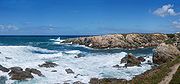
Waves erode coastline as they break on shore releasing their energy; the larger the wave the more energy it releases and the more sediment it moves. Coastlines with longer shores have more room for the waves to disperse their energy, while coasts with cliffs and short shore faces give little room for the wave energy to be dispersed. In these areas the wave energy breaking against the cliffs is higher, and air and water are compressed into cracks in the rock, forcing the rock apart, breaking it down. Sediment deposited by waves comes from eroded cliff faces and is moved along the coastline by the waves.
Sediment deposited by rivers is the dominant influence on the amount of sediment located on a coastline. Today riverine deposition at the coast is often blocked by dams and other human regulatory devices, which remove the sediment from the stream by causing it to be deposited inland.
Like the ocean which shapes them, coasts are a dynamic environment with constant change. The Earth's natural processes, particularly sea level rises, waves and various weather
phenomena, have resulted in the erosion
, accretion
and reshaping of coasts as well as flooding and creation of continental shelves
and drowned river valleys (ria
s).
as the mixture of fresh water and salt
water in estuaries
provides many nutrients for marine life. Salt marsh
es and beach
es also support a diversity of plant
s, animal
s, and insect
s crucial to the food chain
.
The high level of biodiversity
creates a high level of biological activity, which has attracted human activity for thousands of years.
 An increasing part the global population inhabits coastal regions. Many of the world's major cities have been built on or near good harbor
s and have port
facilities. Jurisdictions that are landlocked
have achieved port status by such measures such as building canal
s.
The coast is a crucial frontier that nations typically defended against military invaders, smugglers and illegal migrants. Fixed Coastal defenses have long been erected in many nations and coastal countries typically have a navy
and some form of coast guard
.
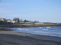
Coasts, especially those with beach
es and warm water are an important draw for tourists. In many island nation
s such as those of the Mediterranean, South Pacific and Caribbean, tourism is central to the economy. Coasts are popular destinations because of recreational activities such as swimming, fishing
, surfing
, boating
, and sunbathing. Growth management
can be a challenge for coastal local authorities
who often struggle to provide the infrastructure
required by new residents.
is thought to be a contributing factor of an accelerated trend in sea level rise which threatens coastal habitat.
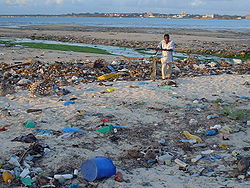
Pollution
can occur from a number of sources: garbage and industrial debris
, the transport
ation of petroleum
in tankers
, increasing the probability of large oil spill
s, small oil spills created by large and small vessels, which flush bilge
water into the ocean.
Fishing has diminished due to habitat degradation
, overfishing
, trawling
, bycatch
and climate change
. Since the growth of global fishing enterprises after the 1950s, intensive fishing has gone from a few concentrated areas to encompass nearly all fisheries. The scraping of the ocean floor in bottom dragging
is devastating to coral, sponges and other long-lived species that do not recover quickly. This destruction alters the functioning of the ecosystem and can permanently alter species composition and biodiversity. Bycatch, the capture of unintended species in the course of fishing, is typically returned the ocean only to die from injuries or exposure. Bycatch represents approximately ¼ of all marine catch. In the case of shrimp capture, the bycatch is five times larger than the shrimp caught.
Also, the melting arctic ice will cause sea rise which will flood costal areas.
, harvesting mangrove for timber and clearing for fishing drove the mangrove forests to low levels, resulting in a loss of habitat and spawning ground for marine life that was unique to the area. These forests also helped to stabilize the coastline. Conservation efforts since the 1980s have partially restored the ecosystem.
s, which are above the high tide mark, such as raised beach
es. Alternatively, a submergent coastline is a coastline which has experienced a rise in sea level, due to a global sea level change, local subsidence
, or isostatic rebound. Submergent coastlines are identifiable by their submerged, or "drowned" landforms, such as ria
s (drowned valleys) and fjord
s.
According to a second principle of classification, a concordant coastline is a coastline where bands of different rock types run parallel to the shore. These rock types are usually of alternating resistance
, so the coastline forms distinctive landforms, such as coves. A discordant coastline is a type of coastline formed when rock types of alternating resistance run perpendicular to the shore. Discordant coastlines feature distinctive landforms because the rocks are eroded
by ocean
wave
s. The less resistant rocks erode faster, creating inlet
s or bays
; the more resistant rocks erode more slowly, remaining as headlands
or outcroppings.
 The following articles describe some coastal landforms:
s living along the coast vary enormously, some live along coasts to nest like puffin
s, sea turtle
s and rockhopper penguin
s. Sea snails
and various kinds of barnacle
s live on the coast and scavenge on food deposited by the sea. Most coastal animals are used to humans in developed areas, such as dolphin
s and seagulls who eat food thrown for them by tourists. Since the coastal areas are all part of the littoral zone, there is a profusion of marine life found just off-coast.
There are many kinds of seabird
s on the coast. Pelican
s and cormorant
s join up with tern
s and oystercatcher
s to forage for fish and shellfish on the coast.
There are also sea lions on the coast of Wales and other countrys.
beds. Kelp is a fast growing seaweed
that grows up to a metre a day. Coral
s and anemone
s are true animals, but live a similar lifestyle as plants do. Mangroves and salt marsh
are important coastal vegetation types in topical and temperate environments respectively.
reported their measured border with Spain
to be 987 km, but the Spanish reported it to be 1214 km. This was the beginning of the coastline problem, which is how to arrive at an estimate of a boundary that is infinite.
The prevailing method of estimating a border (or coastline) was to lay off n equal straight-line segments of length ℓ with dividers on a map or aerial photograph. Each end of the segment must be on the boundary. Investigating the discrepancies in border estimation Richardson discovered what is now termed the Richardson Effect: the sum of the segments is inversely proportional to the common length of the segments. In effect, the shorter the ruler, the longer the measured border; thus, the Spanish and Portuguese geographers were using different-length rulers.
The result most astounding to Richardson is that, as ℓ approaches zero, the length of the coastline approaches infinity
. Richardson had believed, based on Euclidean geometry, that a coastline would approach a fixed length, as do similar estimations of regular geometric figures. For example, the perimeter
of a regular polygon
inscribed in a circle
approaches the circumference
with increasing numbers of sides (and decrease in the length of one side). In Geometric measure theory
such a smooth curve as the circle that can be approximated by small straight segments with a definite limit is termed a rectifiable curve.
invented a new branch of mathematics
, fractal geometry, to describe just such non-rectifiable complexes in nature as the infinite coastline. His own definition of the new figure serving as the basis for his study is:
A key property of the fractal is self-similarity
; that is, at any scale
the same general configuration appears. A coastline is perceived as bays alternating with promontories. No matter how greatly any one small section of coastline is magnified, a similar pattern of bays and promontories on bays and promontories appears, right down to the grains of sand. At that scale the coastline appears as a momentarily shifting, potentially infinitely long thread with a stochastic
arrangement of bays and promontories formed from the small objects at hand. In such a real environment (as opposed to smooth curves) Mandelbrot asserts "coastline length turns out to be an elusive notion that slips between the fingers of those who want to grasp it."
A coastline is definitely to be represented by a fractal. However, there are different kinds of fractals. A coastline is in "a first category of fractals, namely curves whose fractal dimension is greater than 1." That last statement represents an extension by Mandelbrot of Richardson's thought. Mandelbrot's statement of the Richardson Effect is:

where L, coastline length, a function of the measurement unit, ε, is approximated by the expression. F is a constant and D is a parameter that Richardson found depended on the coastline approximated by L. He gave no theoretical explanation but Mandelbrot identified L with a non-integer form of the Hausdorff dimension
, later the fractal dimension. Rearranging the right side of the expression obtains:

where Fε-D must be the number of units ε required to obtain L. The fractal dimension is the number of the dimensions of the figure being used to approximate the fractal: 0 for a dot, 1 for a line, 2 for a square. D in the expression is between 1 and 2, for coastlines typically less than 1.5. The broken line measuring the coast does not extend in one direction nor does it represent an area, but is intermediate. It can be interpreted as a thick line or band of width 2ε. More broken coastlines have greater D and therefore L is longer for the same ε. Mandelbrot showed that D is independent of ε.
East Coast of the United States
The East Coast of the United States, also known as the Eastern Seaboard, refers to the easternmost coastal states in the United States, which touch the Atlantic Ocean and stretch up to Canada. The term includes the U.S...
and West Coasts of the United States
West Coast of the United States
West Coast or Pacific Coast are terms for the westernmost coastal states of the United States. The term most often refers to the states of California, Oregon, and Washington. Although not part of the contiguous United States, Alaska and Hawaii do border the Pacific Ocean but can't be included in...
.
A pelagic coast refers to a coast which fronts the open ocean, as opposed to a more sheltered coast in a gulf
Headlands and bays
Headlands and bays are two related features of the coastal environment.- Geology and geography :Headlands and bays are often found on the same coastline. A bay is surrounded by land on three sides, whereas a headland is surrounded by water on three sides. Headlands are characterized by high,...
or bay
Headlands and bays
Headlands and bays are two related features of the coastal environment.- Geology and geography :Headlands and bays are often found on the same coastline. A bay is surrounded by land on three sides, whereas a headland is surrounded by water on three sides. Headlands are characterized by high,...
. A shore
Shore
A shore or shoreline is the fringe of land at the edge of a large body of water, such as an ocean, sea, or lake. In Physical Oceanography a shore is the wider fringe that is geologically modified by the action of the body of water past and present, while the beach is at the edge of the shore,...
, on the other hand, can refer to parts of the land which adjoin any large body of water, including oceans (sea shore) and lake
Lake
A lake is a body of relatively still fresh or salt water of considerable size, localized in a basin, that is surrounded by land. Lakes are inland and not part of the ocean and therefore are distinct from lagoons, and are larger and deeper than ponds. Lakes can be contrasted with rivers or streams,...
s (lake shore). Similarly, the somewhat related term "bank
Stream bed
A stream bed is the channel bottom of a stream, river or creek; the physical confine of the normal water flow. The lateral confines or channel margins, during all but flood stage, are known as the stream banks or river banks. In fact, a flood occurs when a stream overflows its banks and flows onto...
" refers to the land alongside or sloping down to a river
River
A river is a natural watercourse, usually freshwater, flowing towards an ocean, a lake, a sea, or another river. In a few cases, a river simply flows into the ground or dries up completely before reaching another body of water. Small rivers may also be called by several other names, including...
(riverbank) or to a body of water smaller than a lake. "Bank" is also used in some parts of the world to refer to an artificial ridge of earth intended to retain the water of a river or pond
Pond
A pond is a body of standing water, either natural or man-made, that is usually smaller than a lake. A wide variety of man-made bodies of water are classified as ponds, including water gardens, water features and koi ponds; all designed for aesthetic ornamentation as landscape or architectural...
. In other places this may be called a levee
Levee
A levee, levée, dike , embankment, floodbank or stopbank is an elongated naturally occurring ridge or artificially constructed fill or wall, which regulates water levels...
.
While many scientific experts might agree on a common definition of the term "coast", the delineation of the extents of a coast differ according to jurisdiction
Jurisdiction
Jurisdiction is the practical authority granted to a formally constituted legal body or to a political leader to deal with and make pronouncements on legal matters and, by implication, to administer justice within a defined area of responsibility...
, with many scientific and government authorities in various countries differing for economic and social policy reasons.
Formation
Tide
Tides are the rise and fall of sea levels caused by the combined effects of the gravitational forces exerted by the moon and the sun and the rotation of the Earth....
s often determine the range over which sediment
Sediment
Sediment is naturally occurring material that is broken down by processes of weathering and erosion, and is subsequently transported by the action of fluids such as wind, water, or ice, and/or by the force of gravity acting on the particle itself....
is deposited or eroded. Areas with high tidal ranges allow waves to reach farther up the shore, and areas with lower tidal ranges produce deposition at a smaller elevation interval. The tidal range is influenced by the size and shape of the coastline. Tides do not typically cause erosion by themselves; however, tidal bore
Tidal bore
A tidal bore is a tidal phenomenon in which the leading edge of the incoming tide forms a wave of water that travel up a river or narrow bay against the direction of the river or bay's current...
s can erode as the waves surge up river estuaries
Estuary
An estuary is a partly enclosed coastal body of water with one or more rivers or streams flowing into it, and with a free connection to the open sea....
from the ocean.
Waves erode coastline as they break on shore releasing their energy; the larger the wave the more energy it releases and the more sediment it moves. Coastlines with longer shores have more room for the waves to disperse their energy, while coasts with cliffs and short shore faces give little room for the wave energy to be dispersed. In these areas the wave energy breaking against the cliffs is higher, and air and water are compressed into cracks in the rock, forcing the rock apart, breaking it down. Sediment deposited by waves comes from eroded cliff faces and is moved along the coastline by the waves.
Sediment deposited by rivers is the dominant influence on the amount of sediment located on a coastline. Today riverine deposition at the coast is often blocked by dams and other human regulatory devices, which remove the sediment from the stream by causing it to be deposited inland.
Like the ocean which shapes them, coasts are a dynamic environment with constant change. The Earth's natural processes, particularly sea level rises, waves and various weather
Weather
Weather is the state of the atmosphere, to the degree that it is hot or cold, wet or dry, calm or stormy, clear or cloudy. Most weather phenomena occur in the troposphere, just below the stratosphere. Weather refers, generally, to day-to-day temperature and precipitation activity, whereas climate...
phenomena, have resulted in the erosion
Erosion
Erosion is when materials are removed from the surface and changed into something else. It only works by hydraulic actions and transport of solids in the natural environment, and leads to the deposition of these materials elsewhere...
, accretion
Accretion (geology)
Accretion is a process by which material is added to a tectonic plate or a landmass. This material may be sediment, volcanic arcs, seamounts or other igneous features.-Description:...
and reshaping of coasts as well as flooding and creation of continental shelves
Continental shelf
The continental shelf is the extended perimeter of each continent and associated coastal plain. Much of the shelf was exposed during glacial periods, but is now submerged under relatively shallow seas and gulfs, and was similarly submerged during other interglacial periods. The continental margin,...
and drowned river valleys (ria
Ria
A ria is a coastal inlet formed by the partial submergence of an unglaciated river valley. It is a drowned river valley that remains open to the sea. Typically, rias have a dendritic, treelike outline although they can be straight and without significant branches. This pattern is inherited from the...
s).
Environmental importance
The coast and its adjacent areas on and off shore is an important part of a local ecosystemEcosystem
An ecosystem is a biological environment consisting of all the organisms living in a particular area, as well as all the nonliving , physical components of the environment with which the organisms interact, such as air, soil, water and sunlight....
as the mixture of fresh water and salt
Salt
In chemistry, salts are ionic compounds that result from the neutralization reaction of an acid and a base. They are composed of cations and anions so that the product is electrically neutral...
water in estuaries
Estuary
An estuary is a partly enclosed coastal body of water with one or more rivers or streams flowing into it, and with a free connection to the open sea....
provides many nutrients for marine life. Salt marsh
Marsh
In geography, a marsh, or morass, is a type of wetland that is subject to frequent or continuous flood. Typically the water is shallow and features grasses, rushes, reeds, typhas, sedges, other herbaceous plants, and moss....
es and beach
Beach
A beach is a geological landform along the shoreline of an ocean, sea, lake or river. It usually consists of loose particles which are often composed of rock, such as sand, gravel, shingle, pebbles or cobblestones...
es also support a diversity of plant
Plant
Plants are living organisms belonging to the kingdom Plantae. Precise definitions of the kingdom vary, but as the term is used here, plants include familiar organisms such as trees, flowers, herbs, bushes, grasses, vines, ferns, mosses, and green algae. The group is also called green plants or...
s, animal
Animal
Animals are a major group of multicellular, eukaryotic organisms of the kingdom Animalia or Metazoa. Their body plan eventually becomes fixed as they develop, although some undergo a process of metamorphosis later on in their life. Most animals are motile, meaning they can move spontaneously and...
s, and insect
Insect
Insects are a class of living creatures within the arthropods that have a chitinous exoskeleton, a three-part body , three pairs of jointed legs, compound eyes, and two antennae...
s crucial to the food chain
Food chain
A food web depicts feeding connections in an ecological community. Ecologists can broadly lump all life forms into one of two categories called trophic levels: 1) the autotrophs, and 2) the heterotrophs...
.
The high level of biodiversity
Biodiversity
Biodiversity is the degree of variation of life forms within a given ecosystem, biome, or an entire planet. Biodiversity is a measure of the health of ecosystems. Biodiversity is in part a function of climate. In terrestrial habitats, tropical regions are typically rich whereas polar regions...
creates a high level of biological activity, which has attracted human activity for thousands of years.
Human uses of coasts
Harbor
A harbor or harbour , or haven, is a place where ships, boats, and barges can seek shelter from stormy weather, or else are stored for future use. Harbors can be natural or artificial...
s and have port
Port
A port is a location on a coast or shore containing one or more harbors where ships can dock and transfer people or cargo to or from land....
facilities. Jurisdictions that are landlocked
Landlocked
A landlocked country is a country entirely enclosed by land, or whose only coastlines lie on closed seas. There are 48 landlocked countries in the world, including partially recognized states...
have achieved port status by such measures such as building canal
Canal
Canals are man-made channels for water. There are two types of canal:#Waterways: navigable transportation canals used for carrying ships and boats shipping goods and conveying people, further subdivided into two kinds:...
s.
The coast is a crucial frontier that nations typically defended against military invaders, smugglers and illegal migrants. Fixed Coastal defenses have long been erected in many nations and coastal countries typically have a navy
Navy
A navy is the branch of a nation's armed forces principally designated for naval and amphibious warfare; namely, lake- or ocean-borne combat operations and related functions...
and some form of coast guard
Coast guard
A coast guard or coastguard is a national organization responsible for various services at sea. However the term implies widely different responsibilities in different countries, from being a heavily armed military force with customs and security duties to being a volunteer organization tasked with...
.
Coasts, especially those with beach
Beach
A beach is a geological landform along the shoreline of an ocean, sea, lake or river. It usually consists of loose particles which are often composed of rock, such as sand, gravel, shingle, pebbles or cobblestones...
es and warm water are an important draw for tourists. In many island nation
Island nation
An island country is a state whose primary territory consists of one or more islands or parts of islands. As of 2011, 47 of the 193 UN member states are island countries.-Politics:...
s such as those of the Mediterranean, South Pacific and Caribbean, tourism is central to the economy. Coasts are popular destinations because of recreational activities such as swimming, fishing
Fishing
Fishing is the activity of trying to catch wild fish. Fish are normally caught in the wild. Techniques for catching fish include hand gathering, spearing, netting, angling and trapping....
, surfing
Surfing
Surfing' is a surface water sport in which the surfer rides a surfboard on the crest and face of a wave which is carrying the surfer towards the shore...
, boating
Boating
Boating is the leisurely activity of travelling by boat, or the recreational use of a boat whether powerboats, sailboats, or man-powered vessels , focused on the travel itself, as well as sports activities, such as fishing or water skiing...
, and sunbathing. Growth management
Growth management
Growth management is a set of techniques used by government to ensure that as the population grows that there are services available to meet their demands. These are not necessarily only government services...
can be a challenge for coastal local authorities
Local government
Local government refers collectively to administrative authorities over areas that are smaller than a state.The term is used to contrast with offices at nation-state level, which are referred to as the central government, national government, or federal government...
who often struggle to provide the infrastructure
Infrastructure
Infrastructure is basic physical and organizational structures needed for the operation of a society or enterprise, or the services and facilities necessary for an economy to function...
required by new residents.
Threats to a coast
Coasts also face many environmental challenges relating to human-induced impacts. The human influence on climate changeClimate change
Climate change is a significant and lasting change in the statistical distribution of weather patterns over periods ranging from decades to millions of years. It may be a change in average weather conditions or the distribution of events around that average...
is thought to be a contributing factor of an accelerated trend in sea level rise which threatens coastal habitat.
Pollution
Marine pollution
Marine pollution occurs when harmful, or potentially harmful effects, can result from the entry into the ocean of chemicals, particles, industrial, agricultural and residential waste, noise, or the spread of invasive organisms. Most sources of marine pollution are land based...
can occur from a number of sources: garbage and industrial debris
Marine debris
Marine debris, also known as marine litter, is human created waste that has deliberately or accidentally become afloat in a lake, sea, ocean or waterway. Oceanic debris tends to accumulate at the centre of gyres and on coastlines, frequently washing aground, when it is known as beach litter or...
, the transport
Transport
Transport or transportation is the movement of people, cattle, animals and goods from one location to another. Modes of transport include air, rail, road, water, cable, pipeline, and space. The field can be divided into infrastructure, vehicles, and operations...
ation of petroleum
Petroleum
Petroleum or crude oil is a naturally occurring, flammable liquid consisting of a complex mixture of hydrocarbons of various molecular weights and other liquid organic compounds, that are found in geologic formations beneath the Earth's surface. Petroleum is recovered mostly through oil drilling...
in tankers
Tank ship
A tanker is a ship designed to transport liquids in bulk. Major types of tankship include the oil tanker, the chemical tanker, and the liquefied natural gas carrier.-Background:...
, increasing the probability of large oil spill
Oil spill
An oil spill is the release of a liquid petroleum hydrocarbon into the environment, especially marine areas, due to human activity, and is a form of pollution. The term is mostly used to describe marine oil spills, where oil is released into the ocean or coastal waters...
s, small oil spills created by large and small vessels, which flush bilge
Bilge
The bilge is the lowest compartment on a ship where the two sides meet at the keel. The word was coined in 1513.-Bilge water:The word is sometimes also used to describe the water that collects in this compartment. Water that does not drain off the side of the deck drains down through the ship into...
water into the ocean.
Fishing has diminished due to habitat degradation
Environmental effects of fishing
The environmental impact of fishing can be divided into issues that involve the availability of fish to be caught, such as overfishing, sustainable fisheries, and fisheries management; and issues that involve the impact of fishing on other elements of the environment, such as by-catch.These...
, overfishing
Overfishing
Overfishing occurs when fishing activities reduce fish stocks below an acceptable level. This can occur in any body of water from a pond to the oceans....
, trawling
Trawling
Trawling is a method of fishing that involves pulling a fishing net through the water behind one or more boats. The net that is used for trawling is called a trawl....
, bycatch
Bycatch
The term “bycatch” is usually used for fish caught unintentionally in a fishery while intending to catch other fish. It may however also indicate untargeted catch in other forms of animal harvesting or collecting...
and climate change
Climate change
Climate change is a significant and lasting change in the statistical distribution of weather patterns over periods ranging from decades to millions of years. It may be a change in average weather conditions or the distribution of events around that average...
. Since the growth of global fishing enterprises after the 1950s, intensive fishing has gone from a few concentrated areas to encompass nearly all fisheries. The scraping of the ocean floor in bottom dragging
Bottom trawling
Bottom trawling is trawling along the sea floor. It is also often referred to as "dragging".The scientific community divides bottom trawling into benthic trawling and demersal trawling...
is devastating to coral, sponges and other long-lived species that do not recover quickly. This destruction alters the functioning of the ecosystem and can permanently alter species composition and biodiversity. Bycatch, the capture of unintended species in the course of fishing, is typically returned the ocean only to die from injuries or exposure. Bycatch represents approximately ¼ of all marine catch. In the case of shrimp capture, the bycatch is five times larger than the shrimp caught.
Also, the melting arctic ice will cause sea rise which will flood costal areas.
Conservation
Extraordinary population growth in the 20th century has placed stress on the planet’s ecosystems. For example, on Saint LuciaSaint Lucia
Saint Lucia is an island country in the eastern Caribbean Sea on the boundary with the Atlantic Ocean. Part of the Lesser Antilles, it is located north/northeast of the island of Saint Vincent, northwest of Barbados and south of Martinique. It covers a land area of 620 km2 and has an...
, harvesting mangrove for timber and clearing for fishing drove the mangrove forests to low levels, resulting in a loss of habitat and spawning ground for marine life that was unique to the area. These forests also helped to stabilize the coastline. Conservation efforts since the 1980s have partially restored the ecosystem.
Types of coast
According to one principle of classification, an emergent coastline is a coastline which has experienced a fall in sea level, because of either a global sea level change, or local uplift. Emergent coastlines are identifiable by the coastal landformLandform
A landform or physical feature in the earth sciences and geology sub-fields, comprises a geomorphological unit, and is largely defined by its surface form and location in the landscape, as part of the terrain, and as such, is typically an element of topography...
s, which are above the high tide mark, such as raised beach
Raised beach
A raised beach, marine terrace, or perched coastline is an emergent coastal landform. Raised beaches and marine terraces are beaches or wave-cut platforms raised above the shore line by a relative fall in the sea level ....
es. Alternatively, a submergent coastline is a coastline which has experienced a rise in sea level, due to a global sea level change, local subsidence
Subsidence
Subsidence is the motion of a surface as it shifts downward relative to a datum such as sea-level. The opposite of subsidence is uplift, which results in an increase in elevation...
, or isostatic rebound. Submergent coastlines are identifiable by their submerged, or "drowned" landforms, such as ria
Ria
A ria is a coastal inlet formed by the partial submergence of an unglaciated river valley. It is a drowned river valley that remains open to the sea. Typically, rias have a dendritic, treelike outline although they can be straight and without significant branches. This pattern is inherited from the...
s (drowned valleys) and fjord
Fjord
Geologically, a fjord is a long, narrow inlet with steep sides or cliffs, created in a valley carved by glacial activity.-Formation:A fjord is formed when a glacier cuts a U-shaped valley by abrasion of the surrounding bedrock. Glacial melting is accompanied by rebound of Earth's crust as the ice...
s.
According to a second principle of classification, a concordant coastline is a coastline where bands of different rock types run parallel to the shore. These rock types are usually of alternating resistance
Geological resistance
Geological resistance is a measure of how well minerals resist erosive factors, and is primarily based on hardness, chemical reactivity and cohesion. The more hardness, less reactivity and more cohesion a mineral has, the less susceptible it will be to erosion...
, so the coastline forms distinctive landforms, such as coves. A discordant coastline is a type of coastline formed when rock types of alternating resistance run perpendicular to the shore. Discordant coastlines feature distinctive landforms because the rocks are eroded
Erosion
Erosion is when materials are removed from the surface and changed into something else. It only works by hydraulic actions and transport of solids in the natural environment, and leads to the deposition of these materials elsewhere...
by ocean
Ocean
An ocean is a major body of saline water, and a principal component of the hydrosphere. Approximately 71% of the Earth's surface is covered by ocean, a continuous body of water that is customarily divided into several principal oceans and smaller seas.More than half of this area is over 3,000...
wave
Wave
In physics, a wave is a disturbance that travels through space and time, accompanied by the transfer of energy.Waves travel and the wave motion transfers energy from one point to another, often with no permanent displacement of the particles of the medium—that is, with little or no associated mass...
s. The less resistant rocks erode faster, creating inlet
Inlet
An inlet is a narrow body of water between islands or leading inland from a larger body of water, often leading to an enclosed body of water, such as a sound, bay, lagoon or marsh. In sea coasts an inlet usually refers to the actual connection between a bay and the ocean and is often called an...
s or bays
Headlands and bays
Headlands and bays are two related features of the coastal environment.- Geology and geography :Headlands and bays are often found on the same coastline. A bay is surrounded by land on three sides, whereas a headland is surrounded by water on three sides. Headlands are characterized by high,...
; the more resistant rocks erode more slowly, remaining as headlands
Headlands and bays
Headlands and bays are two related features of the coastal environment.- Geology and geography :Headlands and bays are often found on the same coastline. A bay is surrounded by land on three sides, whereas a headland is surrounded by water on three sides. Headlands are characterized by high,...
or outcroppings.
Coastal landforms
- BayHeadlands and baysHeadlands and bays are two related features of the coastal environment.- Geology and geography :Headlands and bays are often found on the same coastline. A bay is surrounded by land on three sides, whereas a headland is surrounded by water on three sides. Headlands are characterized by high,...
- CapeHeadlands and baysHeadlands and bays are two related features of the coastal environment.- Geology and geography :Headlands and bays are often found on the same coastline. A bay is surrounded by land on three sides, whereas a headland is surrounded by water on three sides. Headlands are characterized by high,...
- CoveCoveA cove is a small type of bay or coastal inlet. They usually have narrow, restricted entrances, are often circular or oval, and are often inside a larger bay. Small, narrow, sheltered bays, inlets, creeks, or recesses in a coast are often considered coves...
- GulfHeadlands and baysHeadlands and bays are two related features of the coastal environment.- Geology and geography :Headlands and bays are often found on the same coastline. A bay is surrounded by land on three sides, whereas a headland is surrounded by water on three sides. Headlands are characterized by high,...
- HeadlandHeadlands and baysHeadlands and bays are two related features of the coastal environment.- Geology and geography :Headlands and bays are often found on the same coastline. A bay is surrounded by land on three sides, whereas a headland is surrounded by water on three sides. Headlands are characterized by high,...
- PeninsulaPeninsulaA peninsula is a piece of land that is bordered by water on three sides but connected to mainland. In many Germanic and Celtic languages and also in Baltic, Slavic and Hungarian, peninsulas are called "half-islands"....
Cliff erosion
- Much of the sediment deposited along a coast is the result of erosion of a surrounding CliffCliffIn geography and geology, a cliff is a significant vertical, or near vertical, rock exposure. Cliffs are formed as erosion landforms due to the processes of erosion and weathering that produce them. Cliffs are common on coasts, in mountainous areas, escarpments and along rivers. Cliffs are usually...
, or bluff. Sea Cliffs retreat landward because of the constant undercutting of slopes by waves. If the slope/cliff being undercut is made of unconsolidated sediment it will erode at a much faster rate then a cliff made of bedrock. (Easterbrook 1999). - A Natural archNatural archA natural arch or natural bridge is a natural geological formation where a rock arch forms, with an opening underneath. Most natural arches form as a narrow ridge, walled by cliffs, become narrower from erosion, with a softer rock stratum under the cliff-forming stratum gradually eroding out until...
is formed when a sea stacks is eroded through by waves. - Sea caves are made when certain rock beds are more susceptible to erosion than the surrounding rock beds because of different areas of weakness. These areas are eroded at a faster pace creating a hole or crevasse that, through time, by means of wave action and erosion, becomes a cave.
- A StackStack (geology)A stack is a geological landform consisting of a steep and often vertical column or columns of rock in the sea near a coast, isolated by erosion. Stacks are formed through processes of coastal geomorphology, which are entirely natural. Time, wind and water are the only factors involved in the...
is formed when a headland is eroded away by wave and wind action. - A StumpStack (geology)A stack is a geological landform consisting of a steep and often vertical column or columns of rock in the sea near a coast, isolated by erosion. Stacks are formed through processes of coastal geomorphology, which are entirely natural. Time, wind and water are the only factors involved in the...
is a shortened sea stack that has been eroded away or fallen because of instability. - Wave-cut notches are caused by the undercutting of overhanging slopes which leads to increased stress on cliff material and a greater probability that the slope material will fall. The fallen debris accumulates at the bottom of the cliff and is eventually removed by waves.
- A wave-cut platformWave-cut platformA wave-cut platform, or shore platform is the narrow flat area often found at the base of a sea cliff or along the shoreline of a lake, bay, or sea that was created by the action of waves. Wave-cut platforms are often most obvious at low tide when they become visible as huge areas of flat rock...
forms after erosion and retreat of a sea cliff has been occurring for a long time. Gently sloping wave-cut platforms develop early on in the first stages of cliff retreat. Later the length of the platform decreases because the waves lose their energy as they break further off shore (Easterbrook 1999).
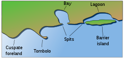
Coastal features formed by sediment
- BeachBeachA beach is a geological landform along the shoreline of an ocean, sea, lake or river. It usually consists of loose particles which are often composed of rock, such as sand, gravel, shingle, pebbles or cobblestones...
- Beach cuspsBeach cuspsBeach cusps are shoreline formations made up of various grades of sediment in an arc pattern. The horns are made up of coarser materials and the embayment contains all the finer grain sediment. They can be found all over the world and are most noticeable on shorelines with coarser sediment such as...
- Boondocks
- Cuspate forelandCuspate forelandCuspate forelands, also known as cuspate barriers or Nesses in Britain, are geographical features found on coastlines and lakeshores that are created primarily by long shore drift. Formed by accretion and progradation of sand and shingle, they extend outwards from the shoreline in a triangular shape...
- Dune systemDuneIn physical geography, a dune is a hill of sand built by wind. Dunes occur in different forms and sizes, formed by interaction with the wind. Most kinds of dunes are longer on the windward side where the sand is pushed up the dune and have a shorter "slip face" in the lee of the wind...
- MudflatMudflatMudflats or mud flats, also known as tidal flats, are coastal wetlands that form when mud is deposited by tides or rivers. They are found in sheltered areas such as bays, bayous, lagoons, and estuaries. Mudflats may be viewed geologically as exposed layers of bay mud, resulting from deposition of...
- Raised beachRaised beachA raised beach, marine terrace, or perched coastline is an emergent coastal landform. Raised beaches and marine terraces are beaches or wave-cut platforms raised above the shore line by a relative fall in the sea level ....
- RiaRiaA ria is a coastal inlet formed by the partial submergence of an unglaciated river valley. It is a drowned river valley that remains open to the sea. Typically, rias have a dendritic, treelike outline although they can be straight and without significant branches. This pattern is inherited from the...
- ShoalShoalShoal, shoals or shoaling may mean:* Shoal, a sandbank or reef creating shallow water, especially where it forms a hazard to shipping* Shoal draught , of a boat with shallow draught which can pass over some shoals: see Draft...
- Strand plainStrand plainA strand plain or strandplain is a broad belt of sand along a shoreline with a surface exhibiting well-defined parallel or semi-parallel sand ridges separated by shallow swales. A strandplain differs from a barrier island in that it lacks either the lagoons or tidales marsh that separate a...
- SpitSpit (landform)A spit or sandspit is a deposition landform found off coasts. At one end, spits connect to land, and extend into the sea. A spit is a type of bar or beach that develops where a re-entrant occurs, such as at cove's headlands, by the process of longshore drift...
- Surge channelSurge channelA surge channel is a narrow inlet on a rocky shoreline. As waves strike the shore, water fills the channel, and drains out again as the waves retreat. The narrow confines of the channel create powerful currents that reverse themselves rapidly as the water level rises and falls.Surge channels can...
- TomboloTomboloA tombolo, from the Italian tombolo, derived from the Latin tumulus, meaning 'mound,' and sometimes translated as ayre , is a deposition landform in which an island is attached to the mainland by a narrow piece of land such as a spit or bar. Once attached, the island is then known as a tied island...
Other features on the coast
- Concordant coastlineConcordant coastlineA concordant, longitudinal, or Pacific type coastline occurs where beds, or layers, of differing rock types are folded into ridges that run parallel to the coast. The outer hard rock provides a protective barrier to erosion of the softer rocks further inland...
- Discordant coastlineDiscordant coastlineA discordant coastline occurs where bands of differing rock type run perpendicular to the coast.The differing resistance to erosion leads to the formation of headlands and bays...
- FjordFjordGeologically, a fjord is a long, narrow inlet with steep sides or cliffs, created in a valley carved by glacial activity.-Formation:A fjord is formed when a glacier cuts a U-shaped valley by abrasion of the surrounding bedrock. Glacial melting is accompanied by rebound of Earth's crust as the ice...
- IslandIslandAn island or isle is any piece of sub-continental land that is surrounded by water. Very small islands such as emergent land features on atolls can be called islets, cays or keys. An island in a river or lake may be called an eyot , or holm...
- Island arcIsland arcAn island arc is a type of archipelago composed of a chain of volcanoes which alignment is arc-shaped, and which are situated parallel and close to a boundary between two converging tectonic plates....
- Machair
Coastal processes
The following articles describe the various geologic processes that affect a coastal zone:- AttritionAttrition (weathering)Attrition is a form of coastal or river erosion, when the bed load is eroded by itself and the bed. As rocks are transported downstream along a riverbed, the regular impacts between the grains themselves and between the grains and the bed cause them to be broken up into smaller fragments. This...
- CurrentsOcean currentAn ocean current is a continuous, directed movement of ocean water generated by the forces acting upon this mean flow, such as breaking waves, wind, Coriolis effect, cabbeling, temperature and salinity differences and tides caused by the gravitational pull of the Moon and the Sun...
- DenudationDenudationIn geology, denudation is the long-term sum of processes that cause the wearing away of the earth’s surface leading to a reduction in elevation and relief of landforms and landscapes...
- DepositionDeposition (geology)Deposition is the geological process by which material is added to a landform or land mass. Fluids such as wind and water, as well as sediment flowing via gravity, transport previously eroded sediment, which, at the loss of enough kinetic energy in the fluid, is deposited, building up layers of...
- ErosionErosionErosion is when materials are removed from the surface and changed into something else. It only works by hydraulic actions and transport of solids in the natural environment, and leads to the deposition of these materials elsewhere...
- FloodFloodA flood is an overflow of an expanse of water that submerges land. The EU Floods directive defines a flood as a temporary covering by water of land not normally covered by water...
ing
- Longshore driftLongshore driftLongshore drift consists of the transportation of sediments along a coast at an angle to the shoreline, which is dependent on prevailing wind direction, swash and backwash. This process occurs in the littoral zone, and in or within close proximity to the surf zone...
- SaltationSaltation (geology)In geology, saltation is a specific type of particle transport by fluids such as wind or water. It occurs when loose material is removed from a bed and carried by the fluid, before being transported back to the surface...
- Sea level change
- eustatic
- isostatic
- SedimentationSedimentationSedimentation is the tendency for particles in suspension to settle out of the fluid in which they are entrained, and come to rest against a barrier. This is due to their motion through the fluid in response to the forces acting on them: these forces can be due to gravity, centrifugal acceleration...
- Coastal sediment supplyCoastal sediment supplyCoastal sediment supply is the transport of sediment to the beach environment by both fluvial and aeolian transport. While aeolian transport plays a role in the overall sedimentary budget for the coastal environment, it is paled in comparison to the fluvial supply which makes up 95% of sediment...
- sediment transportSediment transportSediment transport is the movement of solid particles , typically due to a combination of the force of gravity acting on the sediment, and/or the movement of the fluid in which the sediment is entrained...
- solutionSolutionIn chemistry, a solution is a homogeneous mixture composed of only one phase. In such a mixture, a solute is dissolved in another substance, known as a solvent. The solvent does the dissolving.- Types of solutions :...
- sub-aerial processes
- suspensionSuspension (chemistry)In chemistry, a suspension is a heterogeneous fluid containing solid particles that are sufficiently large for sedimentation. Usually they must be larger than 1 micrometer. The internal phase is dispersed throughout the external phase through mechanical agitation, with the use of certain...
- TideTideTides are the rise and fall of sea levels caused by the combined effects of the gravitational forces exerted by the moon and the sun and the rotation of the Earth....
s - Water waves
- diffractionDiffractionDiffraction refers to various phenomena which occur when a wave encounters an obstacle. Italian scientist Francesco Maria Grimaldi coined the word "diffraction" and was the first to record accurate observations of the phenomenon in 1665...
- refractionRefractionRefraction is the change in direction of a wave due to a change in its speed. It is essentially a surface phenomenon . The phenomenon is mainly in governance to the law of conservation of energy. The proper explanation would be that due to change of medium, the phase velocity of the wave is changed...
- wave breaking
- wave shoalingWave shoalingIn fluid dynamics, wave shoaling is the effect by which surface waves entering shallower water increase in wave height . It is caused by the fact that the group velocity, which is also the wave-energy transport velocity, decreases with the reduction of water depth...
- WeatheringWeatheringWeathering is the breaking down of rocks, soils and minerals as well as artificial materials through contact with the Earth's atmosphere, biota and waters...
Animals
AnimalAnimal
Animals are a major group of multicellular, eukaryotic organisms of the kingdom Animalia or Metazoa. Their body plan eventually becomes fixed as they develop, although some undergo a process of metamorphosis later on in their life. Most animals are motile, meaning they can move spontaneously and...
s living along the coast vary enormously, some live along coasts to nest like puffin
Puffin
Puffins are any of three small species of auk in the bird genus Fratercula with a brightly coloured beak during the breeding season. These are pelagic seabirds that feed primarily by diving in the water. They breed in large colonies on coastal cliffs or offshore islands, nesting in crevices among...
s, sea turtle
Sea turtle
Sea turtles are marine reptiles that inhabit all of the world's oceans except the Arctic.-Distribution:...
s and rockhopper penguin
Rockhopper penguin
The rockhopper penguins are three closely related taxa of crested penguins that have been traditionally treated as a single species and are sometimes split into two or three species. Not all experts agree on the classification of these penguins...
s. Sea snails
Gastropoda
The Gastropoda or gastropods, more commonly known as snails and slugs, are a large taxonomic class within the phylum Mollusca. The class Gastropoda includes snails and slugs of all kinds and all sizes from microscopic to quite large...
and various kinds of barnacle
Barnacle
A barnacle is a type of arthropod belonging to infraclass Cirripedia in the subphylum Crustacea, and is hence related to crabs and lobsters. Barnacles are exclusively marine, and tend to live in shallow and tidal waters, typically in erosive settings. They are sessile suspension feeders, and have...
s live on the coast and scavenge on food deposited by the sea. Most coastal animals are used to humans in developed areas, such as dolphin
Dolphin
Dolphins are marine mammals that are closely related to whales and porpoises. There are almost forty species of dolphin in 17 genera. They vary in size from and , up to and . They are found worldwide, mostly in the shallower seas of the continental shelves, and are carnivores, mostly eating...
s and seagulls who eat food thrown for them by tourists. Since the coastal areas are all part of the littoral zone, there is a profusion of marine life found just off-coast.
There are many kinds of seabird
Seabird
Seabirds are birds that have adapted to life within the marine environment. While seabirds vary greatly in lifestyle, behaviour and physiology, they often exhibit striking convergent evolution, as the same environmental problems and feeding niches have resulted in similar adaptations...
s on the coast. Pelican
Pelican
A pelican, derived from the Greek word πελεκυς pelekys is a large water bird with a large throat pouch, belonging to the bird family Pelecanidae....
s and cormorant
Cormorant
The bird family Phalacrocoracidae is represented by some 40 species of cormorants and shags. Several different classifications of the family have been proposed recently, and the number of genera is disputed.- Names :...
s join up with tern
Tern
Terns are seabirds in the family Sternidae, previously considered a subfamily of the gull family Laridae . They form a lineage with the gulls and skimmers which in turn is related to skuas and auks...
s and oystercatcher
Oystercatcher
The oystercatchers are a group of waders; they form the family Haematopodidae, which has a single genus, Haematopus. They are found on coasts worldwide apart from the polar regions and some tropical regions of Africa and South East Asia...
s to forage for fish and shellfish on the coast.
There are also sea lions on the coast of Wales and other countrys.
Plants
Coastal areas are famous for their kelpKelp
Kelps are large seaweeds belonging to the brown algae in the order Laminariales. There are about 30 different genera....
beds. Kelp is a fast growing seaweed
Seaweed
Seaweed is a loose, colloquial term encompassing macroscopic, multicellular, benthic marine algae. The term includes some members of the red, brown and green algae...
that grows up to a metre a day. Coral
Coral
Corals are marine animals in class Anthozoa of phylum Cnidaria typically living in compact colonies of many identical individual "polyps". The group includes the important reef builders that inhabit tropical oceans and secrete calcium carbonate to form a hard skeleton.A coral "head" is a colony of...
s and anemone
Sea anemone
Sea anemones are a group of water-dwelling, predatory animals of the order Actiniaria; they are named after the anemone, a terrestrial flower. Sea anemones are classified in the phylum Cnidaria, class Anthozoa, subclass Zoantharia. Anthozoa often have large polyps that allow for digestion of larger...
s are true animals, but live a similar lifestyle as plants do. Mangroves and salt marsh
Salt marsh
A salt marsh is an environment in the upper coastal intertidal zone between land and salt water or brackish water, it is dominated by dense stands of halophytic plants such as herbs, grasses, or low shrubs. These plants are terrestrial in origin and are essential to the stability of the salt marsh...
are important coastal vegetation types in topical and temperate environments respectively.
The coastline problem
At some time in the years immediately preceding 1951, Lewis Fry Richardson in researching the possible effect of border lengths on the probability of war noticed that the PortuguesePortugal
Portugal , officially the Portuguese Republic is a country situated in southwestern Europe on the Iberian Peninsula. Portugal is the westernmost country of Europe, and is bordered by the Atlantic Ocean to the West and South and by Spain to the North and East. The Atlantic archipelagos of the...
reported their measured border with Spain
Spain
Spain , officially the Kingdom of Spain languages]] under the European Charter for Regional or Minority Languages. In each of these, Spain's official name is as follows:;;;;;;), is a country and member state of the European Union located in southwestern Europe on the Iberian Peninsula...
to be 987 km, but the Spanish reported it to be 1214 km. This was the beginning of the coastline problem, which is how to arrive at an estimate of a boundary that is infinite.
The prevailing method of estimating a border (or coastline) was to lay off n equal straight-line segments of length ℓ with dividers on a map or aerial photograph. Each end of the segment must be on the boundary. Investigating the discrepancies in border estimation Richardson discovered what is now termed the Richardson Effect: the sum of the segments is inversely proportional to the common length of the segments. In effect, the shorter the ruler, the longer the measured border; thus, the Spanish and Portuguese geographers were using different-length rulers.
The result most astounding to Richardson is that, as ℓ approaches zero, the length of the coastline approaches infinity
Infinity
Infinity is a concept in many fields, most predominantly mathematics and physics, that refers to a quantity without bound or end. People have developed various ideas throughout history about the nature of infinity...
. Richardson had believed, based on Euclidean geometry, that a coastline would approach a fixed length, as do similar estimations of regular geometric figures. For example, the perimeter
Perimeter
A perimeter is a path that surrounds an area. The word comes from the Greek peri and meter . The term may be used either for the path or its length - it can be thought of as the length of the outline of a shape. The perimeter of a circular area is called circumference.- Practical uses :Calculating...
of a regular polygon
Polygon
In geometry a polygon is a flat shape consisting of straight lines that are joined to form a closed chain orcircuit.A polygon is traditionally a plane figure that is bounded by a closed path, composed of a finite sequence of straight line segments...
inscribed in a circle
Circle
A circle is a simple shape of Euclidean geometry consisting of those points in a plane that are a given distance from a given point, the centre. The distance between any of the points and the centre is called the radius....
approaches the circumference
Circumference
The circumference is the distance around a closed curve. Circumference is a special perimeter.-Circumference of a circle:The circumference of a circle is the length around it....
with increasing numbers of sides (and decrease in the length of one side). In Geometric measure theory
Geometric measure theory
In mathematics, geometric measure theory is the study of the geometric properties of the measures of sets , including such things as arc lengths and areas. It uses measure theory to generalize differential geometry to surfaces with mild singularities called rectifiable sets...
such a smooth curve as the circle that can be approximated by small straight segments with a definite limit is termed a rectifiable curve.
Describing a coastline
More than a decade after Richardson's work was finished, Benoît MandelbrotBenoît Mandelbrot
Benoît B. Mandelbrot was a French American mathematician. Born in Poland, he moved to France with his family when he was a child...
invented a new branch of mathematics
Mathematics
Mathematics is the study of quantity, space, structure, and change. Mathematicians seek out patterns and formulate new conjectures. Mathematicians resolve the truth or falsity of conjectures by mathematical proofs, which are arguments sufficient to convince other mathematicians of their validity...
, fractal geometry, to describe just such non-rectifiable complexes in nature as the infinite coastline. His own definition of the new figure serving as the basis for his study is:
A key property of the fractal is self-similarity
Self-similarity
In mathematics, a self-similar object is exactly or approximately similar to a part of itself . Many objects in the real world, such as coastlines, are statistically self-similar: parts of them show the same statistical properties at many scales...
; that is, at any scale
Scale (spatial)
Spatial scale provides a "shorthand" form for discussing relative lengths, areas, distances and sizes. A microclimate, for instance, is one which might occur in a mountain valley or near a lakeshore, whereas a megatrend is one which involves the whole planet....
the same general configuration appears. A coastline is perceived as bays alternating with promontories. No matter how greatly any one small section of coastline is magnified, a similar pattern of bays and promontories on bays and promontories appears, right down to the grains of sand. At that scale the coastline appears as a momentarily shifting, potentially infinitely long thread with a stochastic
Stochastic
Stochastic refers to systems whose behaviour is intrinsically non-deterministic. A stochastic process is one whose behavior is non-deterministic, in that a system's subsequent state is determined both by the process's predictable actions and by a random element. However, according to M. Kac and E...
arrangement of bays and promontories formed from the small objects at hand. In such a real environment (as opposed to smooth curves) Mandelbrot asserts "coastline length turns out to be an elusive notion that slips between the fingers of those who want to grasp it."
A coastline is definitely to be represented by a fractal. However, there are different kinds of fractals. A coastline is in "a first category of fractals, namely curves whose fractal dimension is greater than 1." That last statement represents an extension by Mandelbrot of Richardson's thought. Mandelbrot's statement of the Richardson Effect is:
where L, coastline length, a function of the measurement unit, ε, is approximated by the expression. F is a constant and D is a parameter that Richardson found depended on the coastline approximated by L. He gave no theoretical explanation but Mandelbrot identified L with a non-integer form of the Hausdorff dimension
Hausdorff dimension
thumb|450px|Estimating the Hausdorff dimension of the coast of Great BritainIn mathematics, the Hausdorff dimension is an extended non-negative real number associated with any metric space. The Hausdorff dimension generalizes the notion of the dimension of a real vector space...
, later the fractal dimension. Rearranging the right side of the expression obtains:
where Fε-D must be the number of units ε required to obtain L. The fractal dimension is the number of the dimensions of the figure being used to approximate the fractal: 0 for a dot, 1 for a line, 2 for a square. D in the expression is between 1 and 2, for coastlines typically less than 1.5. The broken line measuring the coast does not extend in one direction nor does it represent an area, but is intermediate. It can be interpreted as a thick line or band of width 2ε. More broken coastlines have greater D and therefore L is longer for the same ε. Mandelbrot showed that D is independent of ε.
See also
- Ballantine ScaleBallantine ScaleThe Ballantine Scale is a biologically defined scale for measuring the degree of exposure level of wave action on a rocky shore. Devised in 1961 by W. J...
- Coastal and Estuarine Research FederationCoastal and Estuarine Research FederationThe Coastal and Estuarine Research Federation is a private, nonprofit organization that was created in 1971. At that time, the members of two regionally-based organizations, the Atlantic Estuarine Research Society and the New England Estuarine Research Society recognized the need for a third...
- Coastal biogeomorphologyCoastal biogeomorphologyOver the past two decades, biogeomorphology has developed as an established research field examining the interrelationship between organisms and geomorphic processes in a variety of environments, both marine, and terrestrial...
- Coastal erosionCoastal erosionCoastal erosion is the wearing away of land and the removal of beach or dune sediments by wave action, tidal currents, wave currents, or drainage...
- Coastal managementCoastal managementIn some jurisdictions the terms sea defense and coastal protection are used to mean, respectively, defense against flooding and erosion...
- Coastline of the North SeaCoastline of the North SeaThe coastline of the North Sea has been evolving since the last glacier receded. The coastline varies from fjords, river estuaries to mudflats. The eastern and western coasts of the North Sea are jagged, as they were stripped by glaciers during the ice ages...
- European Atlas of the SeasEuropean Atlas of the SeasThe European Atlas of the Seas is an interactive electronic atlas on the coasts and seas within and around Europe. The atlas is freely accessible on the internet and is available in English, French and German...
- Coral reefsReefIn nautical terminology, a reef is a rock, sandbar, or other feature lying beneath the surface of the water ....
- How Long Is the Coast of Britain? Statistical Self-Similarity and Fractional DimensionHow Long Is the Coast of Britain? Statistical Self-Similarity and Fractional Dimension"How Long Is the Coast of Britain? Statistical Self-Similarity and Fractional Dimension" is a paper by mathematician Benoît Mandelbrot, first published in Science in 1967. In this paper Mandelbrot discusses self-similar curves that have Hausdorff dimension between 1 and 2...
- Coastal HazardsCoastal development hazardsA coastal development hazard can be defined as the likelihood of an event or incident occurring multiplied by the seriousness of the event or incident if it occurred. The seriousness is controlled by how vulnerable the adversely affected party was to the hazard...
- Coastal DevelopmentCoastal development hazardsA coastal development hazard can be defined as the likelihood of an event or incident occurring multiplied by the seriousness of the event or incident if it occurred. The seriousness is controlled by how vulnerable the adversely affected party was to the hazard...
- Land reclamationLand reclamationLand reclamation, usually known as reclamation, is the process to create new land from sea or riverbeds. The land reclaimed is known as reclamation ground or landfill.- Habitation :...
- List of countries by length of coastline
- List of U.S. states by coastline
- Marine debrisMarine debrisMarine debris, also known as marine litter, is human created waste that has deliberately or accidentally become afloat in a lake, sea, ocean or waterway. Oceanic debris tends to accumulate at the centre of gyres and on coastlines, frequently washing aground, when it is known as beach litter or...
- National Oceanic and Atmospheric Administration Climate and Societal Interactions ProgramNational Oceanic and Atmospheric Administration Climate and Societal Interactions ProgramThe United States National Oceanic and Atmospheric Administration Climate and Societal Interactions Program , formerly the Climate Assessment and Services Division of CPO is designed to support the NOAA Climate Service....
- Nautical chartNautical chartA nautical chart is a graphic representation of a maritime area and adjacent coastal regions. Depending on the scale of the chart, it may show depths of water and heights of land , natural features of the seabed, details of the coastline, navigational hazards, locations of natural and man-made aids...
- Pole of inaccessibilityPole of inaccessibilityA pole of inaccessibility marks a location that is the most challenging to reach owing to its remoteness from geographical features that could provide access...
- Seaside resortSeaside resortA seaside resort is a resort, or resort town, located on the coast. Where a beach is the primary focus for tourists, it may be called a beach resort.- Overview :...
- Marine terraceMarine terraceA marine terrace, coastal terrace, raised beach or perched coastline is a relatively flat, horizontal or gently inclined surface of marine origin, mostly an old abrasion platform which has been lifted out of the sphere of wave activity . Thus it lies above or under the current sea level, depending...