
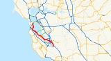
Bayshore Freeway
Encyclopedia
The Bayshore Freeway is a part of U.S. Route 101 in the San Francisco Bay Area
of the U.S. state
of California. It runs along the west shore of the San Francisco Bay
, connecting San Jose with San Francisco. Within the city of San Francisco, the freeway is also known as James Lick
Freeway. The road was originally built as a surface road, the Bayshore Highway, and later upgraded to freeway standards. Before 1964, it was mostly marked as U.S. Route 101 Bypass, with US 101 using the present State Route 82 (El Camino Real
).
. The portion of the highway from San Jose to South San Francisco is relatively straight and flat, running near the west edge of the San Francisco Bay
. Junctions here include SR 237 in Sunnyvale, SR 85 in Mountain View, SR 84 in Menlo Park and Redwood City, SR 92 in San Mateo, and the San Francisco International Airport
and I-380 in San Bruno. In South San Francisco, the freeway curves northeast around San Bruno Mountain
, crossing its east edge at Sierra Point
, and then heads north on a causeway
across the former Candlestick Cove to the San Francisco city line.
 In San Francisco, where the road is also known as the James Lick Freeway, it continues north-northwesterly between Bayview Park and McLaren Park
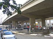
, and crosses I-280 at the Alemany Maze
. There it curves north-northeasterly around Bernal Heights and then northwest around Potrero Hill, meeting the Central Freeway
at the border between the Mission District and South of Market. The Bayshore Freeway ends at the intersection of US 101 and Interstate 80
, which, although signed as Interstate 80, is not officially Interstate 80 until the San Francisco-Oakland Bay Bridge
. The freeway that goes from US 101 to the Bay Bridge that is signed as I-80 but not officially I-80 is called the San Francisco Skyway.
and San Mateo-Hayward Bridges were built across the San Francisco Bay
in the 1920s, San Francisco was bottled up at the north end of a long peninsula
, with driving south on El Camino Real
towards San Jose as the only reasonable alternative to the ferries for crossing the bay. The first of several highways built as an alternate to El Camino Real was the Skyline Boulevard, which was added to the state highway system in 1919. A second route, the Bay Shore Highway (Route 68), became a state highway in 1923, but only from the San Francisco city limits into San Mateo County, where the Dumbarton Bridge would begin. Just prior to the start of construction on the Dumbarton Bridge, San Francisco Supervisor Richard J. Welch
noted that the Bay Shore Highway would need to be built all the way to San Jose as an escape valve for the additional traffic that the bridge would attract.
 The state legislature extended the highway in 1925, defining it to run from near the intersection of Army Street (Cesar Chavez Street) and San Bruno Avenue in San Francisco to a point in San Jose. The governor approved the bill with the stipulation that only the portion between the city limits of San Francisco and San Jose would be a state highway. Construction between South San Francisco and Burlingame had begun by 1924, funded by a $500,000 contribution from San Francisco, and was completed in 1928. A disconnected segment north of San Mateo was built by the state at the same time. It was not until February 1929 that the road was fully paved between San Francisco and Burlingame, and on October 20, 1929 the new highway was officially dedicated to San Mateo, several months after the connecting San Mateo-Hayward Bridge opened (at what is now Third Avenue). Even then, motorists had to wait until May 7, 1931 to reach Jefferson Avenue in Redwood City (near the west end of the four-year-old Dumbarton Bridge). The roadway was extended to Oregon Avenue in Palo Alto in mid-1932, Lawrence Station Road in mid-1933, and to Lafayette Street near Santa Clara, across the Guadalupe River
from San Jose, by 1934. The final piece to Oakland Road (13th Street) in San Jose, which was then the main road - Legislative Route 5 and Sign Route 17 - between San Jose and Oakland, was dedicated on June 12, 1937, over ten years after the Dumbarton Bridge opened in January 1927.
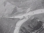
Although the highway was designed and built to what were, at the time, high standards, with a 100-foot (30 m) wide right-of-way in most places, it was accident-prone because it lacked a median barrier. One segment of the so-called "Bloody Bayshore" was "Boneyard Hill", a steep grade through the Visitacion Valley near the San Francisco city line, running past a bone meal
plant. Causes of the crashes included turning conflicts at intersections, and speeding drivers crossing the centerline to use the oncoming lanes as a passing lane
. The roadway was entirely at-grade
except for crossings of rail lines. It generally followed the present alignment of the Bayshore Freeway, but deviated in several places: Old Bayshore Highway in San Jose, Veterans Boulevard in Redwood City, Bayshore Highway in Burlingame, a destroyed section of road through San Francisco International Airport
, and Airport and Bayshore Boulevards from South San Francisco through Brisbane into San Francisco. Within that city, the new highway continued three miles (5 km) along the present Bay Shore Boulevard to Army (Cesar Chavez) Street and Potrero Avenue.
 When the Bayshore Highway was completed in 1937, U.S. Route 101 signs were moved to it from El Camino Real
, and El Camino became U.S. Route 101 Alternate. Businesses along El Camino created the El Camino Real Association to protest the move and resulting loss of business, and by 1939 the main route had been moved back, with the Bayshore Highway becoming U.S. Route 101 Bypass. The two routes split in San Jose at the junction of First and Second Streets near Keyes Street, with the El Camino route mostly following the present SR 82 and the Bayshore route using locally-maintained Second, Reed, and Fourth Streets to reach the state-maintained Bayshore Highway. In San Francisco, they rejoined at the present location of the Alemany Maze
, with the El Camino route following Alemany Boulevard
from near the city line; from there US 101 continued north on Bay Shore Boulevard, Potrero Avenue, and 10th and Fell Streets to Van Ness Avenue, meeting the Bay Bridge approach (US 40/US 50) at Bryant and Harrison Streets. The Bryant/Harrison one-way pair
was added to Route 68 (which already included the bridge) in 1937 and removed in 1947 along with the bridge; in 1961 the new freeway approach became part of Route 68, which was extended back over the bridge to Route 5 at its Oakland landfall.
Construction of an extension to Route 115 (Santa Clara Street, now SR 130) at 30th Street in San Jose began in 1939, and was completed by late 1940. As with the portion between Fourth and 13th Streets, it was not marked as a numbered route. The state legislature authorized an extension beyond San Jose back to El Camino Real near Ford Road in 1947, which was already under construction, and was completed that year. This was the first segment built with interchange
s, and included a median barrier. Despite this, most crossings were at-grade
; only the two ends at Route 115 (Santa Clara Street) and regular US 101 included bridges, the former a diamond interchange
and the latter a simple split with additional access to Ford Road. It also crossed over Coyote Road, though with no access, just south of the Coyote Creek
bridge. The original 1947 bridge over Coyote Road remains, though widened in 1990, and is one of the oldest road-road grade separation
s on the present freeway.
, and crossed the old road at South San Francisco, running just east of it to near the south end of the cut at Sierra Point
. Construction began inside San Francisco in 1950 and was completed in 1958; the new causeway
across Candlestick Cove, connecting the completed section in South San Francisco with San Francisco, was dedicated in mid-1957. In 1951, the state legislature renamed the portion within San Francisco after James Lick
, a California pioneer and philanthropist.
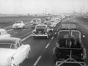
A movement to make the four-lane undivided "Bloody Bayshore" safer all the way to San Jose began in Palo Alto. As a temporary measure, the state lowered the speed limit
, installed traffic signals, closed minor crossroads, and prohibited left turns in places. The community convinced the state to extend the six-lane freeway, which was completed in 1962. The freeway continued to end at the old El Camino Real merge near Ford Road until the early 1980s, when the South Valley Freeway was constructed.
San Francisco Bay Area
The San Francisco Bay Area, commonly known as the Bay Area, is a populated region that surrounds the San Francisco and San Pablo estuaries in Northern California. The region encompasses metropolitan areas of San Francisco, Oakland, and San Jose, along with smaller urban and rural areas...
of the U.S. state
U.S. state
A U.S. state is any one of the 50 federated states of the United States of America that share sovereignty with the federal government. Because of this shared sovereignty, an American is a citizen both of the federal entity and of his or her state of domicile. Four states use the official title of...
of California. It runs along the west shore of the San Francisco Bay
San Francisco Bay
San Francisco Bay is a shallow, productive estuary through which water draining from approximately forty percent of California, flowing in the Sacramento and San Joaquin rivers from the Sierra Nevada mountains, enters the Pacific Ocean...
, connecting San Jose with San Francisco. Within the city of San Francisco, the freeway is also known as James Lick
James Lick
James Lick was an American carpenter, piano builder, land baron, and patron of the sciences. At the time of his death, he was the wealthiest man in California, and left the majority of his estate to social and scientific causes.-Early years:James Lick was born in Stumpstown Pennsylvania on August...
Freeway. The road was originally built as a surface road, the Bayshore Highway, and later upgraded to freeway standards. Before 1964, it was mostly marked as U.S. Route 101 Bypass, with US 101 using the present State Route 82 (El Camino Real
El Camino Real (California)
El Camino Real and sometimes associated with Calle Real usually refers to the 600-mile California Mission Trail, connecting the former Alta California's 21 missions , 4 presidios, and several pueblos, stretching from Mission San Diego de Alcalá in San Diego...
).
Route description
The Bayshore Freeway begins at the Blossom Hill Road interchange on US 101, where SR 82 begins its northwesterly path along Monterey Highway to San Jose. The freeway curves north and northwest, bypassing downtown San Jose to the east, and then curves west-northwest, crossing I-880 and SR 87, the latter just north of the San Jose International AirportSan Jose International Airport
Norman Y. Mineta San Jose International Airport is a city-owned public-use airport serving the city of San Jose in Santa Clara County, California, United States. It is named for San Jose native Norman Yoshio Mineta, who was Transportation Secretary in the Cabinet of George W...
. The portion of the highway from San Jose to South San Francisco is relatively straight and flat, running near the west edge of the San Francisco Bay
San Francisco Bay
San Francisco Bay is a shallow, productive estuary through which water draining from approximately forty percent of California, flowing in the Sacramento and San Joaquin rivers from the Sierra Nevada mountains, enters the Pacific Ocean...
. Junctions here include SR 237 in Sunnyvale, SR 85 in Mountain View, SR 84 in Menlo Park and Redwood City, SR 92 in San Mateo, and the San Francisco International Airport
San Francisco International Airport
San Francisco International Airport is a major international airport located south of downtown San Francisco, California, United States, near the cities of Millbrae and San Bruno in unincorporated San Mateo County. It is often referred to as SFO...
and I-380 in San Bruno. In South San Francisco, the freeway curves northeast around San Bruno Mountain
San Bruno Mountain
San Bruno Mountain in northern San Mateo County, California is the northernmost part of the Santa Cruz Mountains. Most of the mountain lies within the San Bruno Mountain State Park, a unique open-space island in the midst of the San Francisco Peninsula's urbanization. Next to the state park is the...
, crossing its east edge at Sierra Point
Sierra Point, Brisbane, California
Sierra Point is a small peninsula that extends outward into the San Francisco Bay, located in Brisbane, San Mateo County, California . It is at approximately . There are several class A office buildings at Sierra Point including the Dakin Building and the Hitachi Building...
, and then heads north on a causeway
Causeway
In modern usage, a causeway is a road or railway elevated, usually across a broad body of water or wetland.- Etymology :When first used, the word appeared in a form such as “causey way” making clear its derivation from the earlier form “causey”. This word seems to have come from the same source by...
across the former Candlestick Cove to the San Francisco city line.
McLaren Park
McLaren Park is a park in south-eastern San Francisco. McLaren Park is the second largest park in San Francisco after Golden Gate Park. The park is surrounded mostly by the Excelsior, Crocker-Amazon, Visitacion Valley, Portola and University Mound neighborhoods.-History:McLaren Park was once a...
, and crosses I-280 at the Alemany Maze
Alemany Maze
Alemany Maze is the name given to the interchange between the James Lick Freeway and the John F. Foran Freeway in the city of San Francisco...
. There it curves north-northeasterly around Bernal Heights and then northwest around Potrero Hill, meeting the Central Freeway
Central Freeway
The Central Freeway is a roughly one-mile elevated freeway in San Francisco, California, United States, connecting the Bayshore/James Lick Freeway with the Hayes Valley neighborhood. Most of the freeway is part of US 101, which exits at Mission Street on the way to the Golden Gate Bridge...
at the border between the Mission District and South of Market. The Bayshore Freeway ends at the intersection of US 101 and Interstate 80
Interstate 80
Interstate 80 is the second-longest Interstate Highway in the United States, following Interstate 90. It is a transcontinental artery running from downtown San Francisco, California to Teaneck, New Jersey in the New York City Metropolitan Area...
, which, although signed as Interstate 80, is not officially Interstate 80 until the San Francisco-Oakland Bay Bridge
San Francisco-Oakland Bay Bridge
The San Francisco – Oakland Bay Bridge is a pair of bridges spanning San Francisco Bay of California, in the United States. Forming part of Interstate 80 and of the direct road route between San Francisco and Oakland, it carries approximately 270,000 vehicles per day on its two decks...
. The freeway that goes from US 101 to the Bay Bridge that is signed as I-80 but not officially I-80 is called the San Francisco Skyway.
Initial construction
Before the DumbartonDumbarton Bridge (California)
The Dumbarton Bridge is the southernmost of the highway bridges that span the San Francisco Bay in California. Carrying over 81,000 vehicles daily, it is also the shortest bridge across San Francisco Bay at 1.63 miles...
and San Mateo-Hayward Bridges were built across the San Francisco Bay
San Francisco Bay
San Francisco Bay is a shallow, productive estuary through which water draining from approximately forty percent of California, flowing in the Sacramento and San Joaquin rivers from the Sierra Nevada mountains, enters the Pacific Ocean...
in the 1920s, San Francisco was bottled up at the north end of a long peninsula
San Francisco Peninsula
The San Francisco Peninsula is a peninsula in the San Francisco Bay Area that separates the San Francisco Bay from the Pacific Ocean. On its northern tip is the City and County of San Francisco. Its southern base is in Santa Clara County, including the cities of Palo Alto, Los Altos, and Mountain...
, with driving south on El Camino Real
El Camino Real (California)
El Camino Real and sometimes associated with Calle Real usually refers to the 600-mile California Mission Trail, connecting the former Alta California's 21 missions , 4 presidios, and several pueblos, stretching from Mission San Diego de Alcalá in San Diego...
towards San Jose as the only reasonable alternative to the ferries for crossing the bay. The first of several highways built as an alternate to El Camino Real was the Skyline Boulevard, which was added to the state highway system in 1919. A second route, the Bay Shore Highway (Route 68), became a state highway in 1923, but only from the San Francisco city limits into San Mateo County, where the Dumbarton Bridge would begin. Just prior to the start of construction on the Dumbarton Bridge, San Francisco Supervisor Richard J. Welch
Richard J. Welch
Richard Joseph Welch was a U.S. Representative from California.Born in Monroe County, New York, Welch was educated in the public schools.He moved to California in early boyhood and settled in San Francisco....
noted that the Bay Shore Highway would need to be built all the way to San Jose as an escape valve for the additional traffic that the bridge would attract.
Guadalupe River (California)
The Guadalupe River is a short river in California whose headwater creeks originate in the Santa Cruz Mountains near the summit of Loma Prieta and Mount Umunhum. The river mainstem now begins on the Santa Clara Valley floor at the northern end of Lake Almaden, which is fed by Los Alamitos Creek and...
from San Jose, by 1934. The final piece to Oakland Road (13th Street) in San Jose, which was then the main road - Legislative Route 5 and Sign Route 17 - between San Jose and Oakland, was dedicated on June 12, 1937, over ten years after the Dumbarton Bridge opened in January 1927.
Although the highway was designed and built to what were, at the time, high standards, with a 100-foot (30 m) wide right-of-way in most places, it was accident-prone because it lacked a median barrier. One segment of the so-called "Bloody Bayshore" was "Boneyard Hill", a steep grade through the Visitacion Valley near the San Francisco city line, running past a bone meal
Bone meal
Bone meal is a mixture of crushed and coarsely ground bones that is used as an organic fertilizer for plants and formerly in animal feed. As a slow-release fertilizer, bone meal is primarily used as a source of phosphorus....
plant. Causes of the crashes included turning conflicts at intersections, and speeding drivers crossing the centerline to use the oncoming lanes as a passing lane
Passing lane
A passing lane or overtaking lane is the lane on a multi-lane highway or motorway closest to the center of the road ....
. The roadway was entirely at-grade
At-grade intersection
An at-grade intersection is a junction at which two or more transport axes cross at the same level .-Traffic management:With areas of high or fast traffic, an at-grade intersection normally requires a traffic control device such as a stop sign, traffic light or railway signal to manage conflicting...
except for crossings of rail lines. It generally followed the present alignment of the Bayshore Freeway, but deviated in several places: Old Bayshore Highway in San Jose, Veterans Boulevard in Redwood City, Bayshore Highway in Burlingame, a destroyed section of road through San Francisco International Airport
San Francisco International Airport
San Francisco International Airport is a major international airport located south of downtown San Francisco, California, United States, near the cities of Millbrae and San Bruno in unincorporated San Mateo County. It is often referred to as SFO...
, and Airport and Bayshore Boulevards from South San Francisco through Brisbane into San Francisco. Within that city, the new highway continued three miles (5 km) along the present Bay Shore Boulevard to Army (Cesar Chavez) Street and Potrero Avenue.
El Camino Real (California)
El Camino Real and sometimes associated with Calle Real usually refers to the 600-mile California Mission Trail, connecting the former Alta California's 21 missions , 4 presidios, and several pueblos, stretching from Mission San Diego de Alcalá in San Diego...
, and El Camino became U.S. Route 101 Alternate. Businesses along El Camino created the El Camino Real Association to protest the move and resulting loss of business, and by 1939 the main route had been moved back, with the Bayshore Highway becoming U.S. Route 101 Bypass. The two routes split in San Jose at the junction of First and Second Streets near Keyes Street, with the El Camino route mostly following the present SR 82 and the Bayshore route using locally-maintained Second, Reed, and Fourth Streets to reach the state-maintained Bayshore Highway. In San Francisco, they rejoined at the present location of the Alemany Maze
Alemany Maze
Alemany Maze is the name given to the interchange between the James Lick Freeway and the John F. Foran Freeway in the city of San Francisco...
, with the El Camino route following Alemany Boulevard
Alemany Boulevard
Alemany Boulevard is an east–west street in San Francisco, California. The boulevard was named for Archbishop Joseph Sadoc Alemany, the first bishop of the Roman Catholic Archdiocese of San Francisco....
from near the city line; from there US 101 continued north on Bay Shore Boulevard, Potrero Avenue, and 10th and Fell Streets to Van Ness Avenue, meeting the Bay Bridge approach (US 40/US 50) at Bryant and Harrison Streets. The Bryant/Harrison one-way pair
One-way pair
A one-way pair, one-way couple, or just couplet is a pair of parallel, usually one-way streets that carry opposite directions of a signed route or major traffic flow, or sometimes opposite directions of a bus or streetcar route....
was added to Route 68 (which already included the bridge) in 1937 and removed in 1947 along with the bridge; in 1961 the new freeway approach became part of Route 68, which was extended back over the bridge to Route 5 at its Oakland landfall.
Construction of an extension to Route 115 (Santa Clara Street, now SR 130) at 30th Street in San Jose began in 1939, and was completed by late 1940. As with the portion between Fourth and 13th Streets, it was not marked as a numbered route. The state legislature authorized an extension beyond San Jose back to El Camino Real near Ford Road in 1947, which was already under construction, and was completed that year. This was the first segment built with interchange
Interchange (road)
In the field of road transport, an interchange is a road junction that typically uses grade separation, and one or more ramps, to permit traffic on at least one highway to pass through the junction without directly crossing any other traffic stream. It differs from a standard intersection, at which...
s, and included a median barrier. Despite this, most crossings were at-grade
At-grade intersection
An at-grade intersection is a junction at which two or more transport axes cross at the same level .-Traffic management:With areas of high or fast traffic, an at-grade intersection normally requires a traffic control device such as a stop sign, traffic light or railway signal to manage conflicting...
; only the two ends at Route 115 (Santa Clara Street) and regular US 101 included bridges, the former a diamond interchange
Diamond interchange
A diamond interchange is a common type of road junction, used where a freeway crosses a minor road. The freeway itself is grade-separated from the minor road, one crossing the other over a bridge...
and the latter a simple split with additional access to Ford Road. It also crossed over Coyote Road, though with no access, just south of the Coyote Creek
Coyote Creek
Coyote Creek is a river that flows through the Santa Clara Valley in California, United States.-History:Coyote Creek was originally named Arroyo del Coyote by Padre Pedro Font when the de Anza Expedition reached it on Sunday, March 31, 1776....
bridge. The original 1947 bridge over Coyote Road remains, though widened in 1990, and is one of the oldest road-road grade separation
Grade separation
Grade separation is the method of aligning a junction of two or more transport axes at different heights so that they will not disrupt the traffic flow on other transit routes when they cross each other. The composition of such transport axes does not have to be uniform; it can consist of a...
s on the present freeway.
Reconstruction
By 1940, at the dawn of the freeway era, the state was making plans to convert the Bayshore Highway into a ten-lane Bayshore Freeway between San Francisco and Palo Alto. The first piece built was from Peninsula Avenue at the San Mateo-Burlingame line to South San Francisco. This six-lane freeway, completed in 1949, followed the existing highway to Broadway in Burlingame, but then took a more inland alignment past the San Francisco International AirportSan Francisco International Airport
San Francisco International Airport is a major international airport located south of downtown San Francisco, California, United States, near the cities of Millbrae and San Bruno in unincorporated San Mateo County. It is often referred to as SFO...
, and crossed the old road at South San Francisco, running just east of it to near the south end of the cut at Sierra Point
Sierra Point, Brisbane, California
Sierra Point is a small peninsula that extends outward into the San Francisco Bay, located in Brisbane, San Mateo County, California . It is at approximately . There are several class A office buildings at Sierra Point including the Dakin Building and the Hitachi Building...
. Construction began inside San Francisco in 1950 and was completed in 1958; the new causeway
Causeway
In modern usage, a causeway is a road or railway elevated, usually across a broad body of water or wetland.- Etymology :When first used, the word appeared in a form such as “causey way” making clear its derivation from the earlier form “causey”. This word seems to have come from the same source by...
across Candlestick Cove, connecting the completed section in South San Francisco with San Francisco, was dedicated in mid-1957. In 1951, the state legislature renamed the portion within San Francisco after James Lick
James Lick
James Lick was an American carpenter, piano builder, land baron, and patron of the sciences. At the time of his death, he was the wealthiest man in California, and left the majority of his estate to social and scientific causes.-Early years:James Lick was born in Stumpstown Pennsylvania on August...
, a California pioneer and philanthropist.
A movement to make the four-lane undivided "Bloody Bayshore" safer all the way to San Jose began in Palo Alto. As a temporary measure, the state lowered the speed limit
Speed limit
Road speed limits are used in most countries to regulate the speed of road vehicles. Speed limits may define maximum , minimum or no speed limit and are normally indicated using a traffic sign...
, installed traffic signals, closed minor crossroads, and prohibited left turns in places. The community convinced the state to extend the six-lane freeway, which was completed in 1962. The freeway continued to end at the old El Camino Real merge near Ford Road until the early 1980s, when the South Valley Freeway was constructed.
Exit list
- Note: Except where prefixed with a letter, postmiles were measured in 1964, based on the alignment as it existed at that time, and do not necessarily reflect current mileage. The numbers reset at county lines; the start and end postmiles in each county are given in the county column.
County Location Postmile # Exit numberAn exit number is a number assigned to a road junction, usually an exit from a freeway. It is usually marked on the same sign as the destinations of the exit, as well as a sign in the gore....Destinations Notes Santa Clara Santa Clara County, CaliforniaSanta Clara County is a county located at the southern end of the San Francisco Bay Area in the U.S. state of California. As of 2010 it had a population of 1,781,642. The county seat is San Jose. The highly urbanized Santa Clara Valley within Santa Clara County is also known as Silicon Valley...
SCL R28.61-52.55San Jose San Jose, CaliforniaSan Jose is the third-largest city in California, the tenth-largest in the U.S., and the county seat of Santa Clara County which is located at the southern end of San Francisco Bay...R28.61 Continuation beyond SR 82 R28.61 378 30.10 380 Hellyer Avenue 31.00 381 Yerba Buena Road Southbound exit is part of exit 382 31.70 382 Capitol Expressway (CR G21) 33.03 383 Tully Road 34.55 385A Story Road Signed as exit 385 northbound 34.87 385B Signed as exit 384 northbound R35.76 386A R36.14 386B McKee Road, Julian Street 37.73 388A Oakland Road, 13th Street Former SR 238 California State Route 238State Route 238 is a north–south highway in the U.S. state of California. The route is a divided multilane surface highway in the southeastern part of the San Francisco Bay Area. SR 238 connects Interstate 580 in Castro Valley and Interstate 680 in Fremont.-Route description:SR 238 goes...38.30 388 Signed as exits 388B (north) and 388C (south) 38.80 389A Old Bayshore Highway Northbound exit and entrance 39.29 389B Brokaw Road, First Street Signed as exit 389 southbound 39.93 390 Southbound exit and northbound entrance 40.70 391 Trimble Road, De la Cruz Boulevard – Santa Clara Santa Clara, CaliforniaSanta Clara , founded in 1777 and incorporated in 1852, is a city in Santa Clara County, in the U.S. state of California. The city is the site of the eighth of 21 California missions, Mission Santa Clara de Asís, and was named after the mission. The Mission and Mission Gardens are located on the...Signed as exits 391A (Trimble Road) and 391B (De la Cruz Boulevard) southbound Santa Clara Santa Clara, CaliforniaSanta Clara , founded in 1777 and incorporated in 1852, is a city in Santa Clara County, in the U.S. state of California. The city is the site of the eighth of 21 California missions, Mission Santa Clara de Asís, and was named after the mission. The Mission and Mission Gardens are located on the...41.98 392 San Tomas Expressway, Montague Expressway (CR G4) 42.73 393 Great America Parkway, Bowers Avenue Sunnyvale Sunnyvale, CaliforniaSunnyvale is a city in Santa Clara County, California, United States. It is one of the major cities that make up the Silicon Valley located in the San Francisco Bay Area...43.85 394 Lawrence Expressway (CR G2) 44.83 395 Fair Oaks Avenue Signed as exits 395A (north) and 395B (south) southbound 45.68 396A  Malthilda Avenue north to SR 237California State Route 237State Route 237 runs from El Camino Real in Mountain View to Interstate 680 in Milpitas. It runs south of the San Francisco Bay, connecting the East Bay to the Peninsula.This route is part of the California Freeway and Expressway System....
eastNorthbound exit and southbound entrance 45.68 396B Mathilda Avenue south – Sunnyvale Sunnyvale, CaliforniaSunnyvale is a city in Santa Clara County, California, United States. It is one of the major cities that make up the Silicon Valley located in the San Francisco Bay Area...Signed as exit 396A southbound; former SR 85 California State Route 85State Route 85 is a freeway which connects Mountain View and southern San Jose. The entire freeway is named the West Valley Freeway. The majority of the route is also named the Norman Y. Mineta Highway, with the exception of the portion of Highway 85 passing through Saratoga which is named the CHP...46.13 396B Southbound exit and northbound entrance 46.13 396C Northbound exit and southbound entrance Mountain View Mountain View, California-Downtown:Mountain View has a pedestrian-friendly downtown centered on Castro Street. The downtown area consists of the seven blocks of Castro Street from the Downtown Mountain View Station transit center in the north to the intersection with El Camino Real in the south...47.01 397 Ellis Street 47.89 398A Moffett Boulevard, NASA Parkway Signed as exit 398 northbound 48.10 398B Southbound exit and northbound entrance 48.60 399A Shoreline Boulevard – Mountain View Mountain View, California-Downtown:Mountain View has a pedestrian-friendly downtown centered on Castro Street. The downtown area consists of the seven blocks of Castro Street from the Downtown Mountain View Station transit center in the north to the intersection with El Camino Real in the south...Signed as exit 399 southbound 48.97 399B Old Middlefield Way Northbound exit and southbound entrance 49.61 400A Amphitheatre Parkway, Rengstorff Avenue Signed as exits 400A (Amphitheatre Parkway) and 400B (Rengstorff Avenue) northbound 50.32 400C San Antonio Road Signed as exits 400B (north) and 400C (south) southbound Palo Alto Palo Alto, CaliforniaPalo Alto is a California charter city located in the northwest corner of Santa Clara County, in the San Francisco Bay Area of California, United States. The city shares its borders with East Palo Alto, Mountain View, Los Altos, Los Altos Hills, Stanford, Portola Valley, and Menlo Park. It is...52.01 402 Oregon Expressway (CR G3) 52.17 402 Embarcadero Road San Mateo San Mateo County, CaliforniaSan Mateo County is a county located in the San Francisco Bay Area of the U.S. state of California. It covers most of the San Francisco Peninsula just south of San Francisco, and north of Santa Clara County. San Francisco International Airport is located at the northern end of the county, and...
SM 0.00-26.11East Palo Alto East Palo Alto, CaliforniaEast Palo Alto is a city in San Mateo County, California, United States.-Overview:As of the 2010 census, the population of East Palo Alto was 28,155. It is situated on the San Francisco Peninsula, roughly halfway between the cities of San Francisco and San Jose...0.89 403 University Avenue (to SR 109 California State Route 109State Route 109 is a short, unsigned state highway in the U.S. state of California. It is the portion of University Avenue that runs between U.S. Route 101 and State Route 84 in East Palo Alto and Menlo Park. The route is unsigned; however, it is noted on programs like Yahoo Maps.-Route...
)1.87 404 Willow Road (SR 114 California State Route 114State Route 114 is a short state highway in the U.S. state of California that runs between U.S. Route 101 and State Route 84 in East Palo Alto and Menlo Park...
)Signed as exits 404A (east) and 404B (west) Menlo Park Menlo Park, CaliforniaMenlo Park, California is a city at the eastern edge of San Mateo County, in the San Francisco Bay Area of California, in the United States. It is bordered by San Francisco Bay on the north and east; East Palo Alto, Palo Alto, and Stanford to the south; Atherton, North Fair Oaks, and Redwood City...3.59 406 South end of SR 84 overlap Redwood City Redwood City, CaliforniaRedwood City is a California charter city located on the San Francisco Peninsula in Northern California, approximately 27 miles south of San Francisco, and 24 miles north of San Jose. Redwood City's history spans from its earliest inhabitation by the Ohlone people, to its tradition as a port for...5.39 408 North end of SR 84 overlap 6.62 409 Whipple Avenue – Redwood City Redwood City, CaliforniaRedwood City is a California charter city located on the San Francisco Peninsula in Northern California, approximately 27 miles south of San Francisco, and 24 miles north of San Jose. Redwood City's history spans from its earliest inhabitation by the Ohlone people, to its tradition as a port for...San Carlos San Carlos, CaliforniaSan Carlos is a city in San Mateo County, California, USA on the San Francisco Peninsula, about halfway between San Francisco and San Jose. It is an affluent small residential suburb located between Belmont to the north and Redwood City to the south. San Carlos' ZIP code is 94070, and it is within...411 Brittan Avenue Southbound exit and entrance 8.40 411 Holly Street, Redwood Shores Parkway – San Carlos San Carlos, CaliforniaSan Carlos is a city in San Mateo County, California, USA on the San Francisco Peninsula, about halfway between San Francisco and San Jose. It is an affluent small residential suburb located between Belmont to the north and Redwood City to the south. San Carlos' ZIP code is 94070, and it is within...412 Harbor Boulevard Southbound exit and entrance Belmont Belmont, CaliforniaBelmont is a city in San Mateo County, California, United States. It is in the San Francisco Bay Area, located half-way down the San Francisco Peninsula between San Mateo and San Carlos. It was originally part of the Rancho de las Pulgas, for which one of its main roads, the Alameda de las Pulgas,...9.55 412 Marine Parkway, Ralston Avenue – Belmont Belmont, CaliforniaBelmont is a city in San Mateo County, California, United States. It is in the San Francisco Bay Area, located half-way down the San Francisco Peninsula between San Mateo and San Carlos. It was originally part of the Rancho de las Pulgas, for which one of its main roads, the Alameda de las Pulgas,...Former Legislative Route 214 San Mateo San Mateo, CaliforniaSan Mateo is a city in San Mateo County, California, United States, in the San Francisco Bay Area. With a population of approximately 100,000 , it is one of the larger suburbs on the San Francisco Peninsula, located between Burlingame to the north, Foster City to the east, Belmont to the south,...11.15 414A Hillsdale Boulevard – Foster City Foster City, CaliforniaFoster City is an affluent planned city located in San Mateo County, California, 94404. As of the 2010 census, the city had a total population of 30,567. Forbes ranked Foster City #10 on their 2009 list of America's Top 25 Towns to Live Well. Money has also recognized Foster City multiple times as...11.90 414B 11.90 414B Fashion Island Boulevard No northbound exit 12.69 415 Kehoe Avenue Northbound exit and entrance 13.46 416 3rd Avenue Former SR 92 California State Route 92State Route 92 is an east-west highway in the San Francisco Bay area between Half Moon Bay near the coast in the west and downtown Hayward at its junction with State Route 238 and State Route 185. It is most notable for being the route that traverses the San Mateo Bridge. It has interchanges with...14.33 417A Dore Avenue Northbound exit and entrance 14.33 417 Poplar Avenue Southbound exit and entrance 14.69 417B Peninsula Avenue – Burlingame Burlingame, CaliforniaBurlingame is a city in San Mateo County, California. It is located on the San Francisco Peninsula and has a significant shoreline on San Francisco Bay. The city is named after diplomat Anson Burlingame. It is renowned for its many surviving examples of Victorian architecture, its affluence, and...Northbound exit and entrance Burlingame Burlingame, CaliforniaBurlingame is a city in San Mateo County, California. It is located on the San Francisco Peninsula and has a significant shoreline on San Francisco Bay. The city is named after diplomat Anson Burlingame. It is renowned for its many surviving examples of Victorian architecture, its affluence, and...419A Anza Boulevard Northbound exit and entrance 16.58 419B Broadway – Burlingame Burlingame, CaliforniaBurlingame is a city in San Mateo County, California. It is located on the San Francisco Peninsula and has a significant shoreline on San Francisco Bay. The city is named after diplomat Anson Burlingame. It is renowned for its many surviving examples of Victorian architecture, its affluence, and...Millbrae Millbrae, CaliforniaMillbrae is a city in San Mateo County, California, United States, just west of San Francisco Bay, with San Bruno on the north and Burlingame on the south. The population was 21,532 at the 2010 census.-History:...17.95 420 Millbrae Avenue – Millbrae Millbrae, CaliforniaMillbrae is a city in San Mateo County, California, United States, just west of San Francisco Bay, with San Bruno on the north and Burlingame on the south. The population was 21,532 at the 2010 census.-History:...San Bruno San Bruno, CaliforniaSan Bruno is a city in San Mateo County, California, United States. The population was 41,114 at the 2010 census.The city is adjacent to San Francisco International Airport and Golden Gate National Cemetery.-Geography:San Bruno is located at...19.12 422 San Francisco International Airport San Francisco International AirportSan Francisco International Airport is a major international airport located south of downtown San Francisco, California, United States, near the cities of Millbrae and San Bruno in unincorporated San Mateo County. It is often referred to as SFO...Southbound exit is part of exit 423A R20.39 423A San Bruno Avenue R20.72 423B South San Francisco South San Francisco, CaliforniaSouth San Francisco is a city in San Mateo County, California, United States, located on the San Francisco Peninsula in the San Francisco Bay Area...R20.72 423C North Access Road (I-380 Interstate 380 (California)Interstate 380 is a short 3.3-mile east–west spur Interstate Highway in the San Francisco Bay Area of Northern California, connecting Interstate 280 in San Bruno to U.S. Route 101 near the San Francisco International Airport . The highway primarily consists of only three intersections:...
east) – North Cargo AreaSouthbound exit is part of exit 423A 21.69 424 South Airport Boulevard 21.92 425A Grand Avenue – Downtown South San Francisco No southbound entrance 22.71 425B Oyster Point Boulevard 425C South San Francisco South San Francisco, CaliforniaSouth San Francisco is a city in San Mateo County, California, United States, located on the San Francisco Peninsula in the San Francisco Bay Area...
(Airport Boulevard)Southbound exit and entrance Brisbane Brisbane, CaliforniaBrisbane is a small city located in the northern part of San Mateo County, California on the lower slopes of San Bruno Mountain. It is on the northeastern edge of South San Francisco, next to the San Francisco Bay and near the San Francisco International Airport.The population was 4,282 as of...23.39 426A Brisbane Brisbane, CaliforniaBrisbane is a small city located in the northern part of San Mateo County, California on the lower slopes of San Bruno Mountain. It is on the northeastern edge of South San Francisco, next to the San Francisco Bay and near the San Francisco International Airport.The population was 4,282 as of...
, Cow PalaceCow PalaceCow Palace is an indoor arena, in Daly City, California, situated on the city's border with neighboring San Francisco, notable as a sporting arena.-History:...
(Bayshore Boulevard)Northbound exit only 23.66 426B Sierra Point Parkway, Marina Boulevard – Brisbane Brisbane, CaliforniaBrisbane is a small city located in the northern part of San Mateo County, California on the lower slopes of San Bruno Mountain. It is on the northeastern edge of South San Francisco, next to the San Francisco Bay and near the San Francisco International Airport.The population was 4,282 as of...Signed as exit 426 southbound; southbound exit and entrance are located 1.2 miles (1.9 km) north of northbound exit and entrance San Francisco
SF 0.00-R4.240.03 429A Tunnel Avenue – Monster Park Monster ParkCandlestick Park is an outdoor sports and entertainment stadium located in San Francisco, California, in the Bayview Heights area. The stadium was originally built as the home of Major League Baseball's San Francisco Giants, who played there from 1960 until moving into Pacific Bell Park in 2000...0.77 429B Third Street – Cow Palace Cow PalaceCow Palace is an indoor arena, in Daly City, California, situated on the city's border with neighboring San Francisco, notable as a sporting arena.-History:...1.11 429C Paul Avenue No northbound entrance; signed as exit 430A southbound 1.77 430B Silver Avenue No northbound entrance 1.98 430A Northbound exit and southbound entrance 1.98 430A Signed as exit 431 southbound 2.00 431 Alemany Boulevard Alemany BoulevardAlemany Boulevard is an east–west street in San Francisco, California. The boulevard was named for Archbishop Joseph Sadoc Alemany, the first bishop of the Roman Catholic Archdiocese of San Francisco....
, Bayshore Boulevard2.92 432 Cesar Chavez Street, Potrero Avenue 4.10 433A Vermont Street Northbound exit only R4.24 433B – Bay Bridge, Oakland Signed as exit 433 southbound R4.24 – Golden Gate Bridge Golden Gate BridgeThe Golden Gate Bridge is a suspension bridge spanning the Golden Gate, the opening of the San Francisco Bay into the Pacific Ocean. As part of both U.S. Route 101 and California State Route 1, the structure links the city of San Francisco, on the northern tip of the San Francisco Peninsula, to...
, San Francisco Civic CenterContinuation beyond I-80