
Santa Barbara County, California
Encyclopedia
Santa Barbara County is a county
located in the southern portion
of the U.S. state
of California
, on the Pacific coast. As of 2010 the county had a population of 423,895. The county seat
is Santa Barbara
and the largest city is Santa Maria
.
, was first settled by Native Americans at least 13,000 years ago. Evidence for a Paleoindian presence has been found in the form of a fluted Clovis
-like point found in the 1980s along the western Santa Barbara Coast, as well as the remains of Arlington Springs Man found on Santa Rosa Island
in the 1960s. For thousands of years, the area was home to the Chumash tribe of Native Americans
, complex hunter-gatherers who lived along the coast and in interior valleys leaving rock art
in many locations including Painted Cave
.
Europeans first contacted the Chumash in AD 1542, when three Spanish ships under the command of Juan Rodriguez Cabrillo
explored the area. The Santa Barbara Channel
received its name from Spanish explorer Sebastian Vizcaino
when he sailed over the channel waters in 1602; he entered the channel on December 4, the day of the feast of Santa Barbara. Although Spanish ships associated with the Manila Galleon trade probably contacted the Chumash intermittently during this "protohistoric" period, the Spanish first colonized Santa Barbara County in AD 1769, when the DeAnza expedition explored the area and laid plans to establish a series of missions and presidios (forts). Mission Santa Barbara
was founded on December 4, 1786 in what is now Santa Barbara
. The county derives its name from the mission.
European contacts had devastating effects on the Chumash Indians, including a series of disease epidemics that drastically reduced Chumash population. The Chumash survived, however, and thousands of Chumash descendants still live in the Santa Barbara area or surrounding counties.
Santa Barbara County was one of the 26 original counties of California, formed in 1850 at the time of statehood. Parts of the county's territory were given to Ventura County
in 1872.
Santa Barbara County has long been divided between competing political interests. North of the Santa Ynez Mountains
, agricultural activities and oil development have long been predominant. Enormous oil fields such as the Orcutt
, Lompoc
, Santa Maria Valley, and Cat Canyon fields provided jobs and a steady supply of oil, gas, and asphalt since the first oil discovery in the Solomon Hills in 1901. In recent years, major oil companies have left the area, turning over their oil leases to small independents, and decommissioning some leases areas that were no longer profitable. The northern portion contains a large military base, Vandenberg Air Force Base
, and thus military interests are prominent. These influences together create a Republican-leaning northern half.
On the other hand, the southern portion of Santa Barbara county has had an economy based on tourism, with a significant percentage of people with white-collar jobs, formerly in aerospace but more recently in software and other high-tech pursuits. Additionally, the University of California, Santa Barbara
contributes to a liberal populace. The southern portion of the county has a strong history of left-wing activism, with anti-war protests common in Santa Barbara. It is generally believed that the inspiration for Earth Day
was the 1969 Santa Barbara oil spill
; however, Gaylord Nelson
, the senator who proposed the idea, has never directly cited any direct cause for the establishment of the holiday.
Voting patterns in Santa Barbara county indeed reflect a strong split between a "conservative" north and "liberal" south. Coastal Santa Barbara is part of California's California's 23rd congressional district
, which is held by Democrat Lois Capps; the inland is part of the 24th district
, which is held by Republican Elton Gallegly
. In the State Assembly
, Santa Barbara is in the 33rd and 35th districts, which are held by Republican Katcho Achadjian
and Democrat Pedro Nava
, respectively. In the State Senate
, Santa Barbara is part of the 15th and 19th districts, which are held by Republicans Sam Blakeslee
and Tony Strickland
, respectively.
Overall, Santa Barbara is a Democratic-leaning county in Presidential
and congressional
elections. The last Republican to win a majority in the county was George H. W. Bush
in 1988
.
On November 4, 2008 Santa Barbara County voted 53.1 % against Proposition 8 which amended the California Constitution to ban same-sex marriages. It was the only county in Southern California to vote against it.
The County is governed by a five member Board of Supervisors that reflects this ideological split. The Board's three vote majority has shifted over the years between the north and south. The Board majority now includes three members from the southern portion of the County.
The Board of Supervisors appoints a County Executive Officer, who serves at the pleasure of the Board, to operate the County governmental organization. The County government includes 4296 employees and a budget of $757 million. The County provides various services ranging from health services to law enforcement.
. Governor Arnold Schwarzenegger
appointed a formation commission to research the viability of the proposed northern county, which reached the conclusion, stated in its final report (March 28, 2005), that "the proposed County, upon formation in 2006, would not be economically viable at current levels of service." In June 2006, voters rejected the formation of the new county.
The proposed new Mission County would have included the cities of Santa Maria, Lompoc, Guadalupe, Buellton, and Solvang, as well as the Cuyama Valley and Santa Ynez Valley, including Lake Cachuma
. Most of the south coast of Santa Barbara County, along with the Channel Islands, would have remained with that county, with the exception of the stretch from Hollister Ranch
to Point Conception
. Most of the Los Padres National Forest also would have remained with Santa Barbara County.
 According to the 2000 census, the county has a total area of 3789.08 square miles (9,813.7 km²), of which 2737.01 square miles (7,088.8 km²) (or 72.23%) is land and 1052.07 square miles (2,724.8 km²) (or 27.77%) is water. Four of the Channel Islands – San Miguel Island
, Santa Cruz Island
, Santa Rosa Island
and Santa Barbara Island
– are in Santa Barbara County. They form the largest part of the Channel Islands National Park
(which also includes Anacapa Island
in Ventura County
).
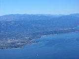
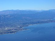
Santa Barbara County has a mountainous interior abutting several coastal plains on the west and south coasts of the county. The largest concentration of population is on the southern coastal plain, referred to as the "south coast" – meaning the part of the county south of the Santa Ynez Mountains
. This region includes the cities of Santa Barbara
, Goleta
, and Carpinteria
, as well as the unincorporated areas of Hope Ranch
, Summerland
, Mission Canyon
, Montecito
and Isla Vista
. North of the mountains are the towns of Santa Ynez
, Solvang
, Buellton
, Lompoc
; the unincorporated towns of Los Olivos
and Ballard
; the unincorporated areas of Mission Hills
and Vandenberg Village
; and Vandenberg Air Force Base
, where the Santa Ynez River flows out to the sea. North of the Santa Ynez Valley are the cities of Santa Maria
and Guadalupe
, and the unincorporated towns of Orcutt
, Los Alamos
, Casmalia
, Garey
, and Sisquoc
. In the extreme northeastern portion of the county are the small cities of New Cuyama
, Cuyama
, and Ventucopa
. As of January 1, 2006, Santa Maria has become the largest city in Santa Barbara County.
The principal mountain ranges of the county are the Santa Ynez Mountains
in the south, and the San Rafael Mountains
and Sierra Madre Mountains
in the interior and northeast. Most of the mountainous area is within the Los Padres National Forest
, and includes two wilderness areas: the San Rafael Wilderness
and the Dick Smith Wilderness
. The highest elevation in the county is 6820 feet (2079 m) at Big Pine Mountain in the San Rafaels.
North of the mountains is the arid and sparsely populated Cuyama Valley
, portions of which are in San Luis Obispo and Ventura Counties. Oil production, ranching, and agriculture dominate the land use in the privately owned parts of the Cuyama Valley; the Los Padres National Forest is adjacent to the south, and regions to the north and northeast are owned by the Bureau of Land Management
and the Nature Conservancy.
Air quality in the county, unlike much of southern California, is generally good because of the prevailing winds off of the Pacific Ocean. The county is in attainment of federal standards for ozone
and particulate matter, but exceeds state standards for these pollutants. Sometimes in late summer and early autumn there are days with higher ozone levels; usually this occurs when there is a low inversion layer
under a stagnant air mass, which traps pollutants underneath. In these cases a traveler into the mountains encounters a curious paradox: the temperature rises as altitude increases. On these days the visibility from the higher summits may be more than a hundred miles, while the population on the coastal plain experiences haze and smog
.
trains and Greyhound Lines
buses.
The southern portion of the county is served by the Santa Barbara Metropolitan Transit District
.
In the North County, the cities of Lompoc, Santa Maria, and Buellton/Solvang have their own bus services.
Commercial flights are available at Santa Barbara Airport
and Santa Maria Public Airport
.
, and 19,442 (4.6%) from two or more races. Hispanic or Latino of any race were 181,687 persons (42.9%); 38.5% of Santa Barbara County is Mexican, 0.4% Salvadoran, 0.4% Guatemalan, and 0.3% Puerto Rican.
of 2000, there were 399,347 people, 136,622 households, and 89,487 families residing in the county. The population density
was 146 people per square mile (56/km²). There were 142,901 housing units at an average density of 52 per square mile (20/km²). The racial makeup of the county was 72.72% White
, 2.30% Black
or African American
, 1.20% Native American
, 4.09% Asian
, 0.18% Pacific Islander
, 15.20% from other races
, and 4.31% from two or more races. 34.22% of the population were Hispanic
or Latino
of any race. 9.1% were of German, 8.5% English
and 6.5% Irish
ancestry according to Census 2000. 26.58% of the population reported speaking Spanish
at home.
There were 136,622 households out of which 32.4% had children under the age of 18 living with them, 51.4% were married couples
living together, 10.0% had a female householder with no husband present, and 34.5% were non-families. 24.3% of all households were made up of individuals and 9.4% had someone living alone who was 65 years of age or older. The average household size was 2.8 and the average family size was 3.33.
In the county the population was spread out with 24.9% under the age of 18, 13.3% from 18 to 24, 29.0% from 25 to 44, 20.1% from 45 to 64, and 12.7% who were 65 years of age or older. The median age was 33 years. For every 100 females there were 100.1 males. For every 100 females age 18 and over, there were 98.1 males.
The median income for a household in the county was $46,677, and the median income for a family was $54,042. Males had a median income of $37,997 versus $29,593 for females. The per capita income
for the county was $23,059. About 8.5% of families and 14.3% of the population were below the poverty line, including 16.3% of those under age 18 and 6.2% of those age 65 or over.
The population of the area south of the Santa Ynez Mountain crest—the portion known as "South County"—was 201,161 according to the 2000 census; thus the population is almost exactly split between north and south. Recent years have shown slow or even negative growth for regions in the south county, while areas in the north county have continued to grow at a faster rate.
There are also a number of private schools in the county. The Los Angeles Archdiocese operates two Catholic
high schools and several elementary schools.
grapes in Santa Barbara County were planted by the missionaries associated with Mission Santa Barbara
late in the 18th century. Since commercial viticulture rebounded in the 1960s, Santa Barbara County has become a prominent viticultural region. The 2004 Alexander Payne film, Sideways
, set in the area, brought additional attention to the county as a wine region.
Famous for ripe, yet elegant, Chardonnay
and Pinot Noir
, the County is also gaining a reputation for Rhone varietals including Syrah and Viognier
. Santa Barbara wine grapes now command among the highest prices anywhere in the state.
Many of the areas planted with wine grapes are mixed in with the rolling hills, ancient oak trees, oil fields, cattle ranches, and natural areas in the central part of the county. The county now claims more than 115 wineries and 21000 acres (85 km²) of vine, with the vast majority of the vineyards in the county's Central Coast American Viticultural Area
s: Santa Maria Valley AVA
, Santa Ynez Valley AVA
, Sta. Rita Hills AVA
, and Happy Canyon AVA each with its own distinct terroir. The county continues to split into AVAs, with Los Olivos AVA and Ballard Canyon AVA currently going through necessary procedures to become their own official AVAs.
. The South of the trail has mostly Rhone style wines due to the warmer climate. In the North, there are Burgundy styles due to the cooler maritime weather, which is also great for Chardonnay and Pinot noir.
Throughout the year numerous events are held in this area by the Foxen Canyon Wine Trail Association. The trail is home to many wineries including Andrew Murray Vineyards
, Fess Parker Winery
and Firestone Vineyard
.
One of the wineries along the trail, Cambria Estate Winery, was featured in the 3rd episode of The Bachelor, an American reality television
series, Season 15, on January 17, 2011.
County (United States)
In the United States, a county is a geographic subdivision of a state , usually assigned some governmental authority. The term "county" is used in 48 of the 50 states; Louisiana is divided into parishes and Alaska into boroughs. Parishes and boroughs are called "county-equivalents" by the U.S...
located in the southern portion
Southern California
Southern California is a megaregion, or megapolitan area, in the southern area of the U.S. state of California. Large urban areas include Greater Los Angeles and Greater San Diego. The urban area stretches along the coast from Ventura through the Southland and Inland Empire to San Diego...
of the U.S. state
U.S. state
A U.S. state is any one of the 50 federated states of the United States of America that share sovereignty with the federal government. Because of this shared sovereignty, an American is a citizen both of the federal entity and of his or her state of domicile. Four states use the official title of...
of California
California
California is a state located on the West Coast of the United States. It is by far the most populous U.S. state, and the third-largest by land area...
, on the Pacific coast. As of 2010 the county had a population of 423,895. The county seat
County seat
A county seat is an administrative center, or seat of government, for a county or civil parish. The term is primarily used in the United States....
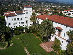
is Santa Barbara
Santa Barbara, California
Santa Barbara is the county seat of Santa Barbara County, California, United States. Situated on an east-west trending section of coastline, the longest such section on the West Coast of the United States, the city lies between the steeply-rising Santa Ynez Mountains and the Pacific Ocean...
and the largest city is Santa Maria
Santa Maria, California
Santa Maria is a city in Santa Barbara County, on the Central Coast of California. The 2010 census population was 100,062, putting it ahead of Santa Barbara for the first time and making it the largest city in the county...
.
History
The Santa Barbara County area, including the Northern Channel IslandsChannel Islands of California
The Channel Islands of California are a chain of eight islands located in the Pacific Ocean off the coast of Southern California along the Santa Barbara Channel in the United States of America...
, was first settled by Native Americans at least 13,000 years ago. Evidence for a Paleoindian presence has been found in the form of a fluted Clovis
Clovis culture
The Clovis culture is a prehistoric Paleo-Indian culture that first appears 11,500 RCYBP , at the end of the last glacial period, characterized by the manufacture of "Clovis points" and distinctive bone and ivory tools...
-like point found in the 1980s along the western Santa Barbara Coast, as well as the remains of Arlington Springs Man found on Santa Rosa Island
Santa Rosa Island, California
Santa Rosa Island is the second largest of the Channel Islands of California at 53,195 acres . Defined by the United States Census Bureau as Block 3009, Block Group 3, Census Tract 29.10 of Santa Barbara County, California, the 2000 census showed an official population of 2 persons. It is part of...
in the 1960s. For thousands of years, the area was home to the Chumash tribe of Native Americans
Native Americans in the United States
Native Americans in the United States are the indigenous peoples in North America within the boundaries of the present-day continental United States, parts of Alaska, and the island state of Hawaii. They are composed of numerous, distinct tribes, states, and ethnic groups, many of which survive as...
, complex hunter-gatherers who lived along the coast and in interior valleys leaving rock art
Rock art
Rock art is a term used in archaeology for any human-made markings made on natural stone. They can be divided into:*Petroglyphs - carvings into stone surfaces*Pictographs - rock and cave paintings...
in many locations including Painted Cave
Chumash Painted Cave State Historic Park, California
Chumash Painted Cave State Historic Park is a unit in the state park system of California, USA, preserving a small sandstone cave adorned with rock art attributed to the Chumash people. Adjoining the small community of Painted Cave, the site is located about north of California State Route 154...
.
Europeans first contacted the Chumash in AD 1542, when three Spanish ships under the command of Juan Rodriguez Cabrillo
Juan Rodríguez Cabrillo
Juan Rodriguez Cabrillo was a Portuguese explorer noted for his exploration of the west coast of North America on behalf of Spain. Cabrillo was the first European explorer to navigate the coast of present day California in the United States...
explored the area. The Santa Barbara Channel
Santa Barbara Channel
The Santa Barbara Channel is a portion of the Pacific Ocean which separates the mainland of California from the northern Channel Islands. It is generally south of the city of Santa Barbara, and west of the city of Ventura....
received its name from Spanish explorer Sebastian Vizcaino
Sebastián Vizcaíno
Sebastián Vizcaíno was a Spanish soldier, entrepreneur, explorer, and diplomat whose varied roles took him to New Spain, the Philippines, the Baja California peninsula, the California coast and Japan.-Early career:...
when he sailed over the channel waters in 1602; he entered the channel on December 4, the day of the feast of Santa Barbara. Although Spanish ships associated with the Manila Galleon trade probably contacted the Chumash intermittently during this "protohistoric" period, the Spanish first colonized Santa Barbara County in AD 1769, when the DeAnza expedition explored the area and laid plans to establish a series of missions and presidios (forts). Mission Santa Barbara
Mission Santa Barbara
In 1840, Alta California and Baja California were removed from the Diocese of Sonora to form the Diocese of Both Californias. Bishop Francisco Garcia Diego y Moreno, OFM, established his cathedra at Mission Santa Barbara, making the chapel the pro-cathedral of the diocese until 1849...
was founded on December 4, 1786 in what is now Santa Barbara
Santa Barbara, California
Santa Barbara is the county seat of Santa Barbara County, California, United States. Situated on an east-west trending section of coastline, the longest such section on the West Coast of the United States, the city lies between the steeply-rising Santa Ynez Mountains and the Pacific Ocean...
. The county derives its name from the mission.
European contacts had devastating effects on the Chumash Indians, including a series of disease epidemics that drastically reduced Chumash population. The Chumash survived, however, and thousands of Chumash descendants still live in the Santa Barbara area or surrounding counties.
Santa Barbara County was one of the 26 original counties of California, formed in 1850 at the time of statehood. Parts of the county's territory were given to Ventura County
Ventura County, California
Ventura County is a county in the southern part of the U.S. state of California. It is located on California's Pacific coast. It is often referred to as the Gold Coast, and has a reputation of being one of the safest populated places and one of the most affluent places in the country...
in 1872.
Politics
In terms of aggregate, the county is strongly left-leaning. However, there is a dramatic difference in gradient between the northern and southern parts of the county.Santa Barbara County has long been divided between competing political interests. North of the Santa Ynez Mountains
Santa Ynez Mountains
The Santa Ynez Mountains are a portion of the Transverse Ranges, part of the Pacific Coast Ranges of the west coast of North America, and are one of the northernmost mountain ranges in Southern California.-Geography:...
, agricultural activities and oil development have long been predominant. Enormous oil fields such as the Orcutt
Orcutt Oil Field
The Orcutt Oil Field is a large oil field in the Solomon Hills south of Orcutt, in Santa Barbara County, California. Discovered in 1901 by William Warren Orcutt, it was the first giant field to be found in Santa Barbara County, and its development engendered the boom town of Orcutt, now the major...
, Lompoc
Lompoc Oil Field
The Lompoc Oil Field is a large oil field in the Purisima Hills north of Lompoc, California, in Santa Barbara County. Discovered in 1903, two years after the discovery of the Orcutt Oil Field in the Solomon Hills, it is one of the oldest oil fields in northern Santa Barbara County, and one of the...
, Santa Maria Valley, and Cat Canyon fields provided jobs and a steady supply of oil, gas, and asphalt since the first oil discovery in the Solomon Hills in 1901. In recent years, major oil companies have left the area, turning over their oil leases to small independents, and decommissioning some leases areas that were no longer profitable. The northern portion contains a large military base, Vandenberg Air Force Base
Vandenberg Air Force Base
Vandenberg Air Force Base is a United States Air Force Base, located approximately northwest of Lompoc, California. It is under the jurisdiction of the 30th Space Wing, Air Force Space Command ....
, and thus military interests are prominent. These influences together create a Republican-leaning northern half.
| Year | GOP Republican Party (United States) The Republican Party is one of the two major contemporary political parties in the United States, along with the Democratic Party. Founded by anti-slavery expansion activists in 1854, it is often called the GOP . The party's platform generally reflects American conservatism in the U.S... |
DEM Democratic Party (United States) The Democratic Party is one of two major contemporary political parties in the United States, along with the Republican Party. The party's socially liberal and progressive platform is largely considered center-left in the U.S. political spectrum. The party has the lengthiest record of continuous... |
Others |
|---|---|---|---|
| 2008 United States presidential election, 2008 The United States presidential election of 2008 was the 56th quadrennial presidential election. It was held on November 4, 2008. Democrat Barack Obama, then the junior United States Senator from Illinois, defeated Republican John McCain, the senior U.S. Senator from Arizona. Obama received 365... |
60.4% 105,614 | 2.4% 4,208 | |
| 2004 United States presidential election, 2004 The United States presidential election of 2004 was the United States' 55th quadrennial presidential election. It was held on Tuesday, November 2, 2004. Republican Party candidate and incumbent President George W. Bush defeated Democratic Party candidate John Kerry, the then-junior U.S. Senator... |
53.2% 90,314 | 1.6% 2,741 | |
| 2000 United States presidential election, 2000 The United States presidential election of 2000 was a contest between Republican candidate George W. Bush, then-governor of Texas and son of former president George H. W. Bush , and Democratic candidate Al Gore, then-Vice President.... |
47.4% 73,411 | 6.5% 10,070 | |
| 1996 United States presidential election, 1996 The United States presidential election of 1996 was a contest between the Democratic national ticket of President Bill Clinton of Arkansas and Vice President Al Gore of Tennessee and the Republican national ticket of former Senator Bob Dole of Kansas for President and former Housing Secretary Jack... |
46.9% 70,650 | 10.7% 16,180 | |
| 1992 United States presidential election, 1992 The United States presidential election of 1992 had three major candidates: Incumbent Republican President George Bush; Democratic Arkansas Governor Bill Clinton, and independent Texas businessman Ross Perot.... |
42.5% 69,215 | 22.2% 36,166 | |
| 1988 United States presidential election, 1988 The United States presidential election of 1988 featured no incumbent president, as President Ronald Reagan was unable to seek re-election after serving the maximum two terms allowed by the Twenty-second Amendment. Reagan's Vice President, George H. W. Bush, won the Republican nomination, while the... |
44.5% 63,586 | 1.3% 1,830 | |
| 1984 United States presidential election, 1984 The United States presidential election of 1984 was a contest between the incumbent President Ronald Reagan, the Republican candidate, and former Vice President Walter Mondale, the Democratic candidate. Reagan was helped by a strong economic recovery from the deep recession of 1981–1982... |
36.0% 51,243 | 1.2% 1,763 | |
| 1980 United States presidential election, 1980 The United States presidential election of 1980 featured a contest between incumbent Democrat Jimmy Carter and his Republican opponent, Ronald Reagan, as well as Republican Congressman John B. Anderson, who ran as an independent... |
31.5% 40,650 | 14.5% 18,716 | |
| 1976 United States presidential election, 1976 The United States presidential election of 1976 followed the resignation of President Richard Nixon in the wake of the Watergate scandal. It pitted incumbent President Gerald Ford, the Republican candidate, against the relatively unknown former governor of Georgia, Jimmy Carter, the Democratic... |
45.9% 55,018 | 3.3% 3,904 | |
| 1972 United States presidential election, 1972 The United States presidential election of 1972 was the 47th quadrennial United States presidential election. It was held on November 7, 1972. The Democratic Party's nomination was eventually won by Senator George McGovern, who ran an anti-war campaign against incumbent Republican President Richard... |
41.6% 50,609 | 3.2% 3,857 | |
| 1968 United States presidential election, 1968 The United States presidential election of 1968 was the 46th quadrennial United States presidential election. Coming four years after Democrat Lyndon B. Johnson won in a historic landslide, it saw Johnson forced out of the race and Republican Richard Nixon elected... |
40.2% 37,565 | 6.2% 5,787 | |
| 1964 United States presidential election, 1964 The United States presidential election of 1964 was held on November 3, 1964. Incumbent President Lyndon B. Johnson had come to office less than a year earlier following the assassination of his predecessor, John F. Kennedy. Johnson, who had successfully associated himself with Kennedy's... |
55.9% 48,381 | 0.1% 85 | |
| 1960 United States presidential election, 1960 The United States presidential election of 1960 was the 44th American presidential election, held on November 8, 1960, for the term beginning January 20, 1961, and ending January 20, 1965. The incumbent president, Republican Dwight D. Eisenhower, was not eligible to run again. The Republican Party... |
43.0% 29,409 | 0.3% 188 | |
| 1956 United States presidential election, 1956 The United States presidential election of 1956 saw a popular Dwight D. Eisenhower successfully run for re-election. The 1956 election was a rematch of 1952, as Eisenhower's opponent in 1956 was Democrat Adlai Stevenson, whom Eisenhower had defeated four years earlier.Incumbent President Eisenhower... |
34.9% 16,925 | 0.6% 265 | |
| 1952 United States presidential election, 1952 The United States presidential election of 1952 took place in an era when Cold War tension between the United States and the Soviet Union was escalating rapidly. In the United States Senate, Republican Senator Joseph McCarthy of Wisconsin had become a national figure after chairing congressional... |
32.4% 15,490 | 0.4% 179 | |
| 1948 United States presidential election, 1948 The United States presidential election of 1948 is considered by most historians as the greatest election upset in American history. Virtually every prediction indicated that incumbent President Harry S. Truman would be defeated by Republican Thomas E. Dewey. Truman won, overcoming a three-way... |
38.0% 13,085 | 3.8% 1,317 | |
| 1944 United States presidential election, 1944 The United States presidential election of 1944 took place while the United States was preoccupied with fighting World War II. President Franklin D. Roosevelt had been in office longer than any other president, but remained popular. Unlike 1940, there was little doubt that Roosevelt would run for... |
53.4% 15,721 | 0.3% 89 | |
| 1940 United States presidential election, 1940 The United States presidential election of 1940 was fought in the shadow of World War II as the United States was emerging from the Great Depression. Incumbent President Franklin D. Roosevelt , a Democrat, broke with tradition and ran for a third term, which became a major issue... |
54.4% 17,237 | 1.1% 334 | |
| 1936 United States presidential election, 1936 The United States presidential election of 1936 was the most lopsided presidential election in the history of the United States in terms of electoral votes. In terms of the popular vote, it was the third biggest victory since the election of 1820, which was not seriously contested.The election took... |
61.1% 15,923 | 1.5% 394 | |
| 1932 United States presidential election, 1932 The United States presidential election of 1932 took place as the effects of the Wall Street Crash of 1929, the Smoot-Hawley Tariff Act of 1930, the Revenue Act of 1932, and the Great Depression were being felt intensely across the country. President Herbert Hoover's popularity was falling as... |
57.4% 13,373 | 4.5% 1,054 | |
| 1928 United States presidential election, 1928 The United States presidential election of 1928 pitted Republican Herbert Hoover against Democrat Al Smith. The Republicans were identified with the booming economy of the 1920s, whereas Smith, a Roman Catholic, suffered politically from Anti-Catholic prejudice, his anti-prohibitionist stance, and... |
29.5% 4,954 | 1.1% 179 | |
| 1924 United States presidential election, 1924 The United States presidential election of 1924 was won by incumbent President Calvin Coolidge, the Republican candidate.Coolidge was vice-president under Warren G. Harding and became president in 1923 when Harding died in office. Coolidge was given credit for a booming economy at home and no... |
9.3% 1,242 | 26.0% 3,461 | |
| 1920 United States presidential election, 1920 The United States presidential election of 1920 was dominated by the aftermath of World War I and a hostile response to certain policies of Woodrow Wilson, the Democratic president. The wartime economic boom had collapsed. Politicians were arguing over peace treaties and the question of America's... |
25.0% 2,586 | 7.5% 773 |
On the other hand, the southern portion of Santa Barbara county has had an economy based on tourism, with a significant percentage of people with white-collar jobs, formerly in aerospace but more recently in software and other high-tech pursuits. Additionally, the University of California, Santa Barbara
University of California, Santa Barbara
The University of California, Santa Barbara, commonly known as UCSB or UC Santa Barbara, is a public research university and one of the 10 general campuses of the University of California system. The main campus is located on a site in Goleta, California, from Santa Barbara and northwest of Los...
contributes to a liberal populace. The southern portion of the county has a strong history of left-wing activism, with anti-war protests common in Santa Barbara. It is generally believed that the inspiration for Earth Day
Earth Day
Earth Day is a day that is intended to inspire awareness and appreciation for the Earth's natural environment. The name and concept of Earth Day was allegedly pioneered by John McConnell in 1969 at a UNESCO Conference in San Francisco. The first Proclamation of Earth Day was by San Francisco, the...
was the 1969 Santa Barbara oil spill
1969 Santa Barbara oil spill
The Santa Barbara oil spill occurred in January and February 1969 in the Santa Barbara Channel, near the city of Santa Barbara in Southern California. It was the largest oil spill in United States waters at the time, and now ranks third after the 2010 Deepwater Horizon and 1989 Exxon Valdez spills...
; however, Gaylord Nelson
Gaylord Nelson
Gaylord Anton Nelson was an American politician from Wisconsin who served as a United States Senator and governor. A Democrat, he was the principal founder of Earth Day.-Public service and leadership:...
, the senator who proposed the idea, has never directly cited any direct cause for the establishment of the holiday.
Voting patterns in Santa Barbara county indeed reflect a strong split between a "conservative" north and "liberal" south. Coastal Santa Barbara is part of California's California's 23rd congressional district
California's 23rd congressional district
California's 23rd congressional district is a congressional district in the U.S. state of California that runs along the Pacific coasts of Ventura, Santa Barbara and San Luis Obispo counties...
, which is held by Democrat Lois Capps; the inland is part of the 24th district
California's 24th congressional district
California's 24th congressional district covers most of Ventura and inland Santa Barbara counties.The district is currently represented by Republican Elton Gallegly.-Voting:-List of representatives:-Election results:-1952:...
, which is held by Republican Elton Gallegly
Elton Gallegly
Elton William Gallegly is the U.S. Representative for , and previously the 23rd and 21st, serving in Congress since 1993. He is a member of the Republican Party.-Early life, education, and pre-congressional career:...
. In the State Assembly
California State Assembly
The California State Assembly is the lower house of the California State Legislature. There are 80 members in the Assembly, representing an approximately equal number of constituents, with each district having a population of at least 420,000...
, Santa Barbara is in the 33rd and 35th districts, which are held by Republican Katcho Achadjian
Katcho Achadjian
Katcho Achadjian is an American politician currently serving in the California State Assembly. He is a Republican representing the 33rd district, encompassing San Luis Obispo County and a part of Santa Barbara County...
and Democrat Pedro Nava
Pedro Nava
Pedro Nava may refer to:*Pedro Nava , Brazilian writer*Pedro Nava , California State Assemblyman...
, respectively. In the State Senate
California State Senate
The California State Senate is the upper house of the California State Legislature. There are 40 state senators. The state legislature meets in the California State Capitol in Sacramento. The Lieutenant Governor is the ex officio President of the Senate and may break a tied vote...
, Santa Barbara is part of the 15th and 19th districts, which are held by Republicans Sam Blakeslee
Sam Blakeslee
Samuel Norman Blakeslee is a Republican California State Senator representing California's 15th State Senate district, a former California State Assemblyman from California's 33rd State Assembly district, and a former State Assembly Republican Leader...
and Tony Strickland
Tony Strickland
Anthony A. "Tony" Strickland is a California State Senator, representing the 19th District. Strickland is a member of the Republican Party and a former Assemblyman, representing the 37th District from 1998 to 2004.-Early life:...
, respectively.
Overall, Santa Barbara is a Democratic-leaning county in Presidential
President of the United States
The President of the United States of America is the head of state and head of government of the United States. The president leads the executive branch of the federal government and is the commander-in-chief of the United States Armed Forces....
and congressional
United States Congress
The United States Congress is the bicameral legislature of the federal government of the United States, consisting of the Senate and the House of Representatives. The Congress meets in the United States Capitol in Washington, D.C....
elections. The last Republican to win a majority in the county was George H. W. Bush
George H. W. Bush
George Herbert Walker Bush is an American politician who served as the 41st President of the United States . He had previously served as the 43rd Vice President of the United States , a congressman, an ambassador, and Director of Central Intelligence.Bush was born in Milton, Massachusetts, to...
in 1988
United States presidential election, 1988
The United States presidential election of 1988 featured no incumbent president, as President Ronald Reagan was unable to seek re-election after serving the maximum two terms allowed by the Twenty-second Amendment. Reagan's Vice President, George H. W. Bush, won the Republican nomination, while the...
.
On November 4, 2008 Santa Barbara County voted 53.1 % against Proposition 8 which amended the California Constitution to ban same-sex marriages. It was the only county in Southern California to vote against it.
The County is governed by a five member Board of Supervisors that reflects this ideological split. The Board's three vote majority has shifted over the years between the north and south. The Board majority now includes three members from the southern portion of the County.
The Board of Supervisors appoints a County Executive Officer, who serves at the pleasure of the Board, to operate the County governmental organization. The County government includes 4296 employees and a budget of $757 million. The County provides various services ranging from health services to law enforcement.
Proposed county splits
In 1978, some residents of the northern area initiated an effort to create a "Los Padres County" out of the northern area of the county; that effort did not succeed. In 2006, northern county organizations initiated a similar secession proposal, to create a proposed Mission CountyMission County proposal
Mission County was a proposed new county in the northern part of Santa Barbara County, California, USA initiated in 2002 by disaffected residents who felt their interests were not being heard. An advisory commission was formed to look into the formation of the proposed county. The commission...
. Governor Arnold Schwarzenegger
Arnold Schwarzenegger
Arnold Alois Schwarzenegger is an Austrian-American former professional bodybuilder, actor, businessman, investor, and politician. Schwarzenegger served as the 38th Governor of California from 2003 until 2011....
appointed a formation commission to research the viability of the proposed northern county, which reached the conclusion, stated in its final report (March 28, 2005), that "the proposed County, upon formation in 2006, would not be economically viable at current levels of service." In June 2006, voters rejected the formation of the new county.
The proposed new Mission County would have included the cities of Santa Maria, Lompoc, Guadalupe, Buellton, and Solvang, as well as the Cuyama Valley and Santa Ynez Valley, including Lake Cachuma
Lake Cachuma
Lake Cachuma is an artificial lake located in the Santa Ynez Valley of central Santa Barbara County, California on the Santa Ynez River adjoining the north side of California State Route 154. The reservoir was created by the construction of Bradbury Dam, a earth-fill structure built by the U.S....
. Most of the south coast of Santa Barbara County, along with the Channel Islands, would have remained with that county, with the exception of the stretch from Hollister Ranch
Hollister Ranch
The region presently known as the Hollister Ranch is defined by of fallow and fertile fields, mountains and valleys along the Pacific Ocean of California between Gaviota State Park and Point Conception. It was the site of some of the oldest known human settlements in the new world, the last...
to Point Conception
Point Conception
Point Conception is a headland along the Pacific coast of U.S. state of California, located in southwestern Santa Barbara County. It is the point where the Santa Barbara Channel meets the Pacific Ocean, and as the corner between the mostly north-south trending portion of coast to the north and the...
. Most of the Los Padres National Forest also would have remained with Santa Barbara County.
Geography
San Miguel Island
San Miguel Island is the westernmost of California's Channel Islands, located across the Santa Barbara Channel in the Pacific Ocean, within Santa Barbara County, California. San Miguel is the sixth-largest of the eight Channel Islands at , including offshore islands and rocks. Prince Island, off...
, Santa Cruz Island
Santa Cruz Island
Santa Cruz Island was the largest privately owned island off the continental United States, but is currently part-owned by the National Park service . The island, located off the coast of California, is long and from wide...
, Santa Rosa Island
Santa Rosa Island, California
Santa Rosa Island is the second largest of the Channel Islands of California at 53,195 acres . Defined by the United States Census Bureau as Block 3009, Block Group 3, Census Tract 29.10 of Santa Barbara County, California, the 2000 census showed an official population of 2 persons. It is part of...
and Santa Barbara Island
Santa Barbara Island
Santa Barbara Island is a small island of the Channel Islands archipelago in California. It is located about off the Southern California coast from the Palos Verdes Peninsula, near Los Angeles in Ventura County, California....
– are in Santa Barbara County. They form the largest part of the Channel Islands National Park
Channel Islands National Park
- External links :* Official site: * *...
(which also includes Anacapa Island
Anacapa Island
Anacapa Island is a small volcanic island located about off the coast of Port Hueneme, California, in Ventura County. The Island is composed of a series of narrow islets six miles long, running in a mostly east-west orientation, five miles east of Santa Cruz Island...
in Ventura County
Ventura County, California
Ventura County is a county in the southern part of the U.S. state of California. It is located on California's Pacific coast. It is often referred to as the Gold Coast, and has a reputation of being one of the safest populated places and one of the most affluent places in the country...
).
Santa Barbara County has a mountainous interior abutting several coastal plains on the west and south coasts of the county. The largest concentration of population is on the southern coastal plain, referred to as the "south coast" – meaning the part of the county south of the Santa Ynez Mountains
Santa Ynez Mountains
The Santa Ynez Mountains are a portion of the Transverse Ranges, part of the Pacific Coast Ranges of the west coast of North America, and are one of the northernmost mountain ranges in Southern California.-Geography:...
. This region includes the cities of Santa Barbara
Santa Barbara, California
Santa Barbara is the county seat of Santa Barbara County, California, United States. Situated on an east-west trending section of coastline, the longest such section on the West Coast of the United States, the city lies between the steeply-rising Santa Ynez Mountains and the Pacific Ocean...
, Goleta
Goleta, California
Goleta is a city in southern Santa Barbara County, California, USA. It was incorporated as a city in 2002, after a long period as the largest unincorporated, populated area in the county. As of the 2000 census, the Census-designated place had a total population of 55,204, however, a significant...
, and Carpinteria
Carpinteria, California
Carpinteria is a small oceanside city located in southeastern Santa Barbara County, California, east of Santa Barbara and northwest of Ventura. The population was 13,040 at the 2010 census, down from 14,194 at the 2000 census....
, as well as the unincorporated areas of Hope Ranch
Hope Ranch, California
Hope Ranch is an unincorporated suburb of Santa Barbara, California, located in Santa Barbara County. As of the 2000 census, the area had an approximate population of 2,200. The ZIP codes are 93105 and 93110, and the community is in area code 805.-History:...
, Summerland
Summerland, California
Summerland is a census-designated place in Santa Barbara County, California, United States. The population was 1,448 at the 2010 census, down from 1,545 at the 2000 census.The town includes a school and a Presbyterian Church...
, Mission Canyon
Mission Canyon, California
Mission Canyon is a census-designated place and an unincorporated suburb of Santa Barbara, California, in Santa Barbara County, United States. The population was 2,381 at the 2010 census, down from 2,610 at the 2000 census....
, Montecito
Montecito, California
Montecito is an unincorporated community in Santa Barbara County, California. As a census-designated place, it had a population of 8,965 in 2010. This does not include areas such as Coast Village Road, that, while usually considered part of Montecito, are actually within the city limits of Santa...
and Isla Vista
Isla Vista, California
Isla Vista is an unincorporated community and census-designated place in Santa Barbara County, California in the United States. As of the 2010 census, it had a population of 23,096. The majority of residents are college students at nearby University of California, Santa Barbara or at Santa...
. North of the mountains are the towns of Santa Ynez
Santa Ynez, California
Santa Ynez is a census-designated place in Santa Barbara County, California, United States. The town of Santa Ynez is one of the communities that make up the Santa Ynez Valley, and features the Santa Ynez Airport for general aviation with a paved 2804 x 75 foot runway. The population was 4,418...
, Solvang
Solvang, California
Solvang is a city in Santa Barbara County, California, United States. It is one of the communities that make up the Santa Ynez Valley. The population was 5,245 at the 2010 census, down from 5,332 at the 2000 census...
, Buellton
Buellton, California
Buellton is a small city in Santa Barbara County, California, United States. The city of Buellton is one of the communities that make up the Santa Ynez Valley...
, Lompoc
Lompoc, California
Lompoc is a city in Santa Barbara County, California, United States. The city was incorporated in 1888. The population was 42,434 at the 2010 census, up from 41,103 at the 2000 census....
; the unincorporated towns of Los Olivos
Los Olivos, California
Los Olivos is a census-designated place in Santa Barbara County, California. The ZIP Code is 93441, and the community is inside area code 805...
and Ballard
Ballard, California
Ballard is a census-designated place in Santa Barbara County, California. The town of Ballard is one of the communities that make up the Santa Ynez Valley. The nearest city is Solvang. The population was 467 at the 2010 census.-History:...
; the unincorporated areas of Mission Hills
Mission Hills, California
Mission Hills is a census-designated place in Santa Barbara County, California, a short distance north of Lompoc on Highway 1. The population was 3,576 at the 2010 census, up from 3,142 at the 2000 census.-Geography:...
and Vandenberg Village
Vandenberg Village, California
Vandenberg Village is a census-designated place in the unincorporated area of Santa Barbara County, California, United States. The population was 6,497 at the 2010 census, up from 5,802 at the 2000 census.-Geography:...
; and Vandenberg Air Force Base
Vandenberg Air Force Base
Vandenberg Air Force Base is a United States Air Force Base, located approximately northwest of Lompoc, California. It is under the jurisdiction of the 30th Space Wing, Air Force Space Command ....
, where the Santa Ynez River flows out to the sea. North of the Santa Ynez Valley are the cities of Santa Maria
Santa Maria, California
Santa Maria is a city in Santa Barbara County, on the Central Coast of California. The 2010 census population was 100,062, putting it ahead of Santa Barbara for the first time and making it the largest city in the county...
and Guadalupe
Guadalupe, California
Guadalupe is a small city located in Santa Barbara County, California. According to the U.S. Census of 2010, the city has a population of 7,080. It was incorporated as a city on May 19, 1946...
, and the unincorporated towns of Orcutt
Orcutt, California
Orcutt is an unincorporated township located in the Santa Maria Valley of California, and a census-designated place; it is in Santa Barbara County, California, United States. Orcutt is named for William W. Orcutt, the manager of the Geological, Land and Engineering Departments of the Union Oil...
, Los Alamos
Los Alamos, California
Los Alamos is a census-designated place in Santa Barbara County, California, United States. Although located in the Los Alamos Valley, the town of Los Alamos is usually considered to be a part of the Santa Ynez Valley community...
, Casmalia
Casmalia, California
Casmalia is a census-designated place in Santa Barbara County, California located just outside the borders of Vandenberg Air Force Base about southwest of Santa Maria. The ZIP Code is 93429, and the community is inside area code 805. The population was 138 at the 2010 census.-History:Casmalia is...
, Garey
Garey, California
Garey is a census-designated place in Santa Barbara County, California located east of U.S. Route 101 about southeast of Santa Maria and north of Sisquoc. The ZIP Code is 93454, and the community is inside area code 805...
, and Sisquoc
Sisquoc, California
Sisquoc is a census-designated place in Santa Barbara County, California located east of U.S. Route 101 about southeast of Santa Maria and south of Garey. The ZIP Code is 93454, and the community is inside area code 805. Sisquoc has a fire station, a church, a Preschool-8 school and a store. It...
. In the extreme northeastern portion of the county are the small cities of New Cuyama
New Cuyama, California
New Cuyama is a census-designated place in the Cuyama Valley, in Santa Barbara County, California, in the United States. It was named after the Chumash Indian word for "clams", most likely due to the millions of petrified prehistoric clamshell fossils that are found in the surrounding areas...
, Cuyama
Cuyama, California
Cuyama is a census-designated place in Santa Barbara County. California. It is located in the Cuyama Valley, near the Carrizo Plain. The Cuyama River runs adjacent to the town, flowing west towards the Pacific Ocean. Cuyama is surrounded by many apricot, peach, and plum orchards. The ZIP Code is...
, and Ventucopa
Ventucopa, California
Ventucopa is an unincorporated town in the upper Cuyama Valley of Santa Barbara County, California. It lies on State Route 33 near the eastern bank of the seasonally-dry Cuyama River, about southeast of Cuyama...
. As of January 1, 2006, Santa Maria has become the largest city in Santa Barbara County.
The principal mountain ranges of the county are the Santa Ynez Mountains
Santa Ynez Mountains
The Santa Ynez Mountains are a portion of the Transverse Ranges, part of the Pacific Coast Ranges of the west coast of North America, and are one of the northernmost mountain ranges in Southern California.-Geography:...
in the south, and the San Rafael Mountains
San Rafael Mountains
The San Rafael Mountains are a mountain range in central Santa Barbara County, California, U.S.. They are part of the Transverse Ranges system of Southern California which in turn are part of the Pacific Coast Ranges system of western North America....
and Sierra Madre Mountains
Sierra Madre Mountains (California)
The Sierra Madre Mountains are a mountain range in northern Santa Barbara County, California, USA. They are a portion of the Inner South Coast Ranges, representing the southernmost part, which are themselves part of the Pacific Coast Ranges of western North America. The Sierra Madre Mountains...
in the interior and northeast. Most of the mountainous area is within the Los Padres National Forest
Los Padres National Forest
Los Padres National Forest is a forest located in southern and central California, which includes most of the mountainous land along the California coast from Ventura to Monterey, extending inland...
, and includes two wilderness areas: the San Rafael Wilderness
San Rafael Wilderness
The San Rafael Wilderness is a wilderness area in the mountains of north central Santa Barbara County, California, USA. It is completely contained within the Los Padres National Forest, and is north of the city of Santa Barbara and east of Santa Maria...
and the Dick Smith Wilderness
Dick Smith Wilderness
The Dick Smith Wilderness is a wilderness area in the mountains of eastern Santa Barbara County, California, USA, with a portion in Ventura County. It is completely contained within the Los Padres National Forest, and is northeast of the city of Santa Barbara and north of the city of Ojai...
. The highest elevation in the county is 6820 feet (2079 m) at Big Pine Mountain in the San Rafaels.
North of the mountains is the arid and sparsely populated Cuyama Valley
Cuyama Valley
The Cuyama Valley is a valley along the Cuyama River in central California, in northern Santa Barbara, southern San Luis Obispo, southwestern Kern, and northwestern Ventura counties. It is a sparsely inhabited area containing two significant towns – Cuyama and New Cuyama – and is largely used for...
, portions of which are in San Luis Obispo and Ventura Counties. Oil production, ranching, and agriculture dominate the land use in the privately owned parts of the Cuyama Valley; the Los Padres National Forest is adjacent to the south, and regions to the north and northeast are owned by the Bureau of Land Management
Bureau of Land Management
The Bureau of Land Management is an agency within the United States Department of the Interior which administers America's public lands, totaling approximately , or one-eighth of the landmass of the country. The BLM also manages of subsurface mineral estate underlying federal, state and private...
and the Nature Conservancy.
Air quality in the county, unlike much of southern California, is generally good because of the prevailing winds off of the Pacific Ocean. The county is in attainment of federal standards for ozone
Ozone
Ozone , or trioxygen, is a triatomic molecule, consisting of three oxygen atoms. It is an allotrope of oxygen that is much less stable than the diatomic allotrope...
and particulate matter, but exceeds state standards for these pollutants. Sometimes in late summer and early autumn there are days with higher ozone levels; usually this occurs when there is a low inversion layer
Inversion (meteorology)
In meteorology, an inversion is a deviation from the normal change of an atmospheric property with altitude. It almost always refers to a temperature inversion, i.e...
under a stagnant air mass, which traps pollutants underneath. In these cases a traveler into the mountains encounters a curious paradox: the temperature rises as altitude increases. On these days the visibility from the higher summits may be more than a hundred miles, while the population on the coastal plain experiences haze and smog
Smog
Smog is a type of air pollution; the word "smog" is a portmanteau of smoke and fog. Modern smog is a type of air pollution derived from vehicular emission from internal combustion engines and industrial fumes that react in the atmosphere with sunlight to form secondary pollutants that also combine...
.
Cities and towns
- BallardBallard, CaliforniaBallard is a census-designated place in Santa Barbara County, California. The town of Ballard is one of the communities that make up the Santa Ynez Valley. The nearest city is Solvang. The population was 467 at the 2010 census.-History:...
- BuelltonBuellton, CaliforniaBuellton is a small city in Santa Barbara County, California, United States. The city of Buellton is one of the communities that make up the Santa Ynez Valley...
- CarpinteriaCarpinteria, CaliforniaCarpinteria is a small oceanside city located in southeastern Santa Barbara County, California, east of Santa Barbara and northwest of Ventura. The population was 13,040 at the 2010 census, down from 14,194 at the 2000 census....
- CasmaliaCasmalia, CaliforniaCasmalia is a census-designated place in Santa Barbara County, California located just outside the borders of Vandenberg Air Force Base about southwest of Santa Maria. The ZIP Code is 93429, and the community is inside area code 805. The population was 138 at the 2010 census.-History:Casmalia is...
- CuyamaCuyama, CaliforniaCuyama is a census-designated place in Santa Barbara County. California. It is located in the Cuyama Valley, near the Carrizo Plain. The Cuyama River runs adjacent to the town, flowing west towards the Pacific Ocean. Cuyama is surrounded by many apricot, peach, and plum orchards. The ZIP Code is...
- GareyGarey, CaliforniaGarey is a census-designated place in Santa Barbara County, California located east of U.S. Route 101 about southeast of Santa Maria and north of Sisquoc. The ZIP Code is 93454, and the community is inside area code 805...
- GaviotaGaviota, CaliforniaGaviota is an unincorporated town in Santa Barbara County, California located about west of Santa Barbara and south of Buellton. Approximately 35 people live in and near Gaviota. The ZIP Code is 93117, and the community is inside area code 805....
- GoletaGoleta, CaliforniaGoleta is a city in southern Santa Barbara County, California, USA. It was incorporated as a city in 2002, after a long period as the largest unincorporated, populated area in the county. As of the 2000 census, the Census-designated place had a total population of 55,204, however, a significant...
- GuadalupeGuadalupe, CaliforniaGuadalupe is a small city located in Santa Barbara County, California. According to the U.S. Census of 2010, the city has a population of 7,080. It was incorporated as a city on May 19, 1946...
- Hollister RanchHollister RanchThe region presently known as the Hollister Ranch is defined by of fallow and fertile fields, mountains and valleys along the Pacific Ocean of California between Gaviota State Park and Point Conception. It was the site of some of the oldest known human settlements in the new world, the last...
- Hope RanchHope Ranch, CaliforniaHope Ranch is an unincorporated suburb of Santa Barbara, California, located in Santa Barbara County. As of the 2000 census, the area had an approximate population of 2,200. The ZIP codes are 93105 and 93110, and the community is in area code 805.-History:...
- Isla VistaIsla Vista, CaliforniaIsla Vista is an unincorporated community and census-designated place in Santa Barbara County, California in the United States. As of the 2010 census, it had a population of 23,096. The majority of residents are college students at nearby University of California, Santa Barbara or at Santa...
- LompocLompoc, CaliforniaLompoc is a city in Santa Barbara County, California, United States. The city was incorporated in 1888. The population was 42,434 at the 2010 census, up from 41,103 at the 2000 census....
- Los AlamosLos Alamos, CaliforniaLos Alamos is a census-designated place in Santa Barbara County, California, United States. Although located in the Los Alamos Valley, the town of Los Alamos is usually considered to be a part of the Santa Ynez Valley community...
- Los OlivosLos Olivos, CaliforniaLos Olivos is a census-designated place in Santa Barbara County, California. The ZIP Code is 93441, and the community is inside area code 805...
- Mission CanyonMission Canyon, CaliforniaMission Canyon is a census-designated place and an unincorporated suburb of Santa Barbara, California, in Santa Barbara County, United States. The population was 2,381 at the 2010 census, down from 2,610 at the 2000 census....
- Mission HillsMission Hills, CaliforniaMission Hills is a census-designated place in Santa Barbara County, California, a short distance north of Lompoc on Highway 1. The population was 3,576 at the 2010 census, up from 3,142 at the 2000 census.-Geography:...
- MontecitoMontecito, CaliforniaMontecito is an unincorporated community in Santa Barbara County, California. As a census-designated place, it had a population of 8,965 in 2010. This does not include areas such as Coast Village Road, that, while usually considered part of Montecito, are actually within the city limits of Santa...
- New CuyamaNew Cuyama, CaliforniaNew Cuyama is a census-designated place in the Cuyama Valley, in Santa Barbara County, California, in the United States. It was named after the Chumash Indian word for "clams", most likely due to the millions of petrified prehistoric clamshell fossils that are found in the surrounding areas...
- OrcuttOrcutt, CaliforniaOrcutt is an unincorporated township located in the Santa Maria Valley of California, and a census-designated place; it is in Santa Barbara County, California, United States. Orcutt is named for William W. Orcutt, the manager of the Geological, Land and Engineering Departments of the Union Oil...
- Painted CavePainted Cave, CaliforniaPainted Cave is an unincorporated community located in the Santa Ynez Mountains and is so named due to its proximity to Painted Cave State Historic Park. It is primarily served by Camino Cielo Road and California State Route 154, which link the community both to the nearby Santa Ynez Valley and...
- Santa BarbaraSanta Barbara, CaliforniaSanta Barbara is the county seat of Santa Barbara County, California, United States. Situated on an east-west trending section of coastline, the longest such section on the West Coast of the United States, the city lies between the steeply-rising Santa Ynez Mountains and the Pacific Ocean...
- Santa MariaSanta Maria, CaliforniaSanta Maria is a city in Santa Barbara County, on the Central Coast of California. The 2010 census population was 100,062, putting it ahead of Santa Barbara for the first time and making it the largest city in the county...
- Santa YnezSanta Ynez, CaliforniaSanta Ynez is a census-designated place in Santa Barbara County, California, United States. The town of Santa Ynez is one of the communities that make up the Santa Ynez Valley, and features the Santa Ynez Airport for general aviation with a paved 2804 x 75 foot runway. The population was 4,418...
- SisquocSisquoc, CaliforniaSisquoc is a census-designated place in Santa Barbara County, California located east of U.S. Route 101 about southeast of Santa Maria and south of Garey. The ZIP Code is 93454, and the community is inside area code 805. Sisquoc has a fire station, a church, a Preschool-8 school and a store. It...
- SolvangSolvang, CaliforniaSolvang is a city in Santa Barbara County, California, United States. It is one of the communities that make up the Santa Ynez Valley. The population was 5,245 at the 2010 census, down from 5,332 at the 2000 census...
- SummerlandSummerland, CaliforniaSummerland is a census-designated place in Santa Barbara County, California, United States. The population was 1,448 at the 2010 census, down from 1,545 at the 2000 census.The town includes a school and a Presbyterian Church...
- Toro CanyonToro Canyon, CaliforniaToro Canyon is a census-designated place in Santa Barbara County, California, United States. The population was 1,508 at the 2010 census, down from 1,697 at the 2000 census.-Geography:Toro Canyon is located at...
- Vandenberg Air Force Base with spaceportSpaceportA spaceport or cosmodrome is a site for launching spacecraft, by analogy with seaport for ships or airport for aircraft. The word spaceport, and even more so cosmodrome, has traditionally been used for sites capable of launching spacecraft into orbit around Earth or on interplanetary trajectories...
- Vandenberg VillageVandenberg Village, CaliforniaVandenberg Village is a census-designated place in the unincorporated area of Santa Barbara County, California, United States. The population was 6,497 at the 2010 census, up from 5,802 at the 2000 census.-Geography:...
- VentucopaVentucopa, CaliforniaVentucopa is an unincorporated town in the upper Cuyama Valley of Santa Barbara County, California. It lies on State Route 33 near the eastern bank of the seasonally-dry Cuyama River, about southeast of Cuyama...
Adjacent counties
- San Luis Obispo County, CaliforniaSan Luis Obispo County, CaliforniaSan Luis Obispo County is a county located along the Pacific Ocean in the Central Coast of the U.S. state of California, between Los Angeles and the San Francisco Bay Area. As of the 2010 census its population was 269,637, up from 246,681 at the 2000 census...
- north - Kern County, CaliforniaKern County, CaliforniaSpreading across the southern end of the California Central Valley, Kern County is the fifth-largest county by population in California. Its economy is heavily linked to agriculture and to petroleum extraction, and there is a strong aviation and space presence. Politically, it has generally...
- northeast - Ventura County, CaliforniaVentura County, CaliforniaVentura County is a county in the southern part of the U.S. state of California. It is located on California's Pacific coast. It is often referred to as the Gold Coast, and has a reputation of being one of the safest populated places and one of the most affluent places in the country...
- east
National protected areas
- Channel Islands National ParkChannel Islands National Park- External links :* Official site: * *...
(part) - Guadalupe-Nipomo Dunes National Wildlife RefugeGuadalupe-Nipomo Dunes National Wildlife RefugeThe Guadalupe-Nipomo Dunes Refuge is located along the southern coast of California, in San Luis Obispo and Santa Barbara Counties. Bordered by the Pacific Ocean to the west and farmland to the east, the refuge encompasses one of the largest coastal dune systems remaining in California.The refuge...
(part) - Los Padres National ForestLos Padres National ForestLos Padres National Forest is a forest located in southern and central California, which includes most of the mountainous land along the California coast from Ventura to Monterey, extending inland...
(part) - Burton Mesa Ecological Reserve
Major highways
- U.S. Route 101
.svg.png)
- State Route 1
 California State Route 1State Route 1 , more often called Highway 1, is a state highway that runs along much of the Pacific coast of the U.S. state of California. It is famous for running along some of the most beautiful coastlines in the world, leading to its designation as an All-American Road.Highway 1 does not run...
 - State Route 33
 California State Route 33State Route 33 is a north–south state highway in the U.S. state of California. SR 33 replaced part of U.S. Route 399 in 1964 during the "great renumbering" of routes. In the unincorporated sections of Kern County it is known as the West Side Highway...
 - State Route 135
 California State Route 135State Route 135 is a state highway in the U.S. state of California, entirely within Santa Barbara County, and is basically a bypass of U.S. Route 101 in northern Santa Barbara County between the town of Los Alamos and the city of Santa Maria....
 - State Route 144
 California State Route 144State Route 144 runs from Route 101 at Milpas Street in Santa Barbara, California to State Route 192 through the Sycamore Canyon.-Route description:...
- State Route 154

- State Route 166
 California State Route 166State Route 166 is a state highway in the U.S. state of California. It connects the Central Coast to the southern San Joaquin Valley....
 - State Route 192

- State Route 217
 California State Route 217State Route 217 is a short two-and-a-half mile long spur route in the U.S. state of California.-Route description:It connects the University of California, Santa Barbara and the Santa Barbara Municipal Airport with U.S. Route 101, which is the major highway that connects Santa Barbara with other...
 - State Route 246
 California State Route 246State Route 246 is a state highway in the U.S. state of California. It runs from Lompoc to Santa Ynez and cuts through the Santa Barbara Wine Country.-Route description:...
Public transportation
Santa Barbara County is served by AmtrakAmtrak
The National Railroad Passenger Corporation, doing business as Amtrak , is a government-owned corporation that was organized on May 1, 1971, to provide intercity passenger train service in the United States. "Amtrak" is a portmanteau of the words "America" and "track". It is headquartered at Union...
trains and Greyhound Lines
Greyhound
The Greyhound is a breed of sighthound that has been primarily bred for coursing game and racing, and the breed has also recently seen a resurgence in its popularity as a pedigree show dog and family pet. It is a gentle and intelligent breed...
buses.
The southern portion of the county is served by the Santa Barbara Metropolitan Transit District
Santa Barbara Metropolitan Transit District
The Santa Barbara Metropolitan Transit District is a public transit agency providing bus service in the southern portion of Santa Barbara County, California...
.
In the North County, the cities of Lompoc, Santa Maria, and Buellton/Solvang have their own bus services.
Airports
- Santa Barbara AirportSanta Barbara AirportSanta Barbara Airport , also known as Santa Barbara Municipal Airport, is a public airport located west of downtown Santa Barbara, California, United States....
, is located near Goleta, west of Santa BarbaraSanta Barbara, CaliforniaSanta Barbara is the county seat of Santa Barbara County, California, United States. Situated on an east-west trending section of coastline, the longest such section on the West Coast of the United States, the city lies between the steeply-rising Santa Ynez Mountains and the Pacific Ocean...
. - Santa Maria Public AirportSanta Maria Public Airport-References:-External links:*...
is located just southwest of Downtown Santa MariaSanta Maria, CaliforniaSanta Maria is a city in Santa Barbara County, on the Central Coast of California. The 2010 census population was 100,062, putting it ahead of Santa Barbara for the first time and making it the largest city in the county...
. - Lompoc AirportLompoc AirportLompoc Airport is a public airport located just north of the city of Lompoc in Santa Barbara County, California, USA.- Facilities and Aircraft :...
is located on the north side of Lompoc. - Santa Ynez AirportSanta Ynez AirportSanta Ynez Airport is a public airport located one mile southeast of the central business district of Santa Ynez, in the Santa Ynez Valley of Santa Barbara County, California, United States. The airport covers and has one runway.Although most U.S...
is just southeast of Santa Ynez.
Commercial flights are available at Santa Barbara Airport
Santa Barbara Airport
Santa Barbara Airport , also known as Santa Barbara Municipal Airport, is a public airport located west of downtown Santa Barbara, California, United States....
and Santa Maria Public Airport
Santa Maria Public Airport
-References:-External links:*...
.
Demographics
2010
The 2010 United States Census reported that Santa Barbara County had a population of 423,895. The racial makeup of Santa Barbara County was 295,124 (69.6%) White, 8,513 (2.0%) African American, 5,485 (1.3%) Native American, 20,665 (4.9%) Asian (1.6% Filipino, 1.0% Chinese, 0.5% Japanese, 0.5% Korean, 0.3% Vietnamese, 0.4% Indian), 806 (0.2%) Pacific Islander, 73,860 (17.4%) from other racesRace (United States Census)
Race and ethnicity in the United States Census, as defined by the Federal Office of Management and Budget and the United States Census Bureau, are self-identification data items in which residents choose the race or races with which they most closely identify, and indicate whether or not they are...
, and 19,442 (4.6%) from two or more races. Hispanic or Latino of any race were 181,687 persons (42.9%); 38.5% of Santa Barbara County is Mexican, 0.4% Salvadoran, 0.4% Guatemalan, and 0.3% Puerto Rican.
| Population reported at 2010 United States Census | |||||||||
|---|---|---|---|---|---|---|---|---|---|
Santa Barbara County, California Santa Barbara County is a county located in the southern portion of the U.S. state of California, on the Pacific coast. As of 2010 the county had a population of 423,895. The county seat is Santa Barbara and the largest city is Santa Maria.-History:... |
Population |
American |
American |
|
Islander |
races Race (United States Census) Race and ethnicity in the United States Census, as defined by the Federal Office of Management and Budget and the United States Census Bureau, are self-identification data items in which residents choose the race or races with which they most closely identify, and indicate whether or not they are... |
more races |
or Latino (of any race) |
|
| Santa Barbara County Santa Barbara County, California Santa Barbara County is a county located in the southern portion of the U.S. state of California, on the Pacific coast. As of 2010 the county had a population of 423,895. The county seat is Santa Barbara and the largest city is Santa Maria.-History:... |
423,895 | 295,124 | 8,513 | 5,485 | 20,665 | 806 | 73,860 | 19,442 | 181,687 |
cities |
Population |
American |
American |
|
Islander |
races Race (United States Census) Race and ethnicity in the United States Census, as defined by the Federal Office of Management and Budget and the United States Census Bureau, are self-identification data items in which residents choose the race or races with which they most closely identify, and indicate whether or not they are... |
more races |
or Latino (of any race) |
|
| Buellton Buellton, California Buellton is a small city in Santa Barbara County, California, United States. The city of Buellton is one of the communities that make up the Santa Ynez Valley... |
4,828 | 3,912 | 37 | 76 | 137 | 5 | 424 | 237 | 1,451 |
| Carpinteria Carpinteria, California Carpinteria is a small oceanside city located in southeastern Santa Barbara County, California, east of Santa Barbara and northwest of Ventura. The population was 13,040 at the 2010 census, down from 14,194 at the 2000 census.... |
13,040 | 9,348 | 109 | 144 | 296 | 15 | 2,599 | 529 | 6,351 |
| Goleta Goleta, California Goleta is a city in southern Santa Barbara County, California, USA. It was incorporated as a city in 2002, after a long period as the largest unincorporated, populated area in the county. As of the 2000 census, the Census-designated place had a total population of 55,204, however, a significant... |
29,888 | 20,833 | 469 | 283 | 2,728 | 26 | 4,182 | 1,367 | 9,824 |
| Guadalupe Guadalupe, California Guadalupe is a small city located in Santa Barbara County, California. According to the U.S. Census of 2010, the city has a population of 7,080. It was incorporated as a city on May 19, 1946... |
7,080 | 3,395 | 74 | 103 | 279 | 5 | 2,783 | 441 | 6,103 |
| Lompoc Lompoc, California Lompoc is a city in Santa Barbara County, California, United States. The city was incorporated in 1888. The population was 42,434 at the 2010 census, up from 41,103 at the 2000 census.... |
42,434 | 25,950 | 2,432 | 750 | 1,615 | 186 | 9,020 | 2,481 | 21,557 |
| Santa Barbara Santa Barbara, California Santa Barbara is the county seat of Santa Barbara County, California, United States. Situated on an east-west trending section of coastline, the longest such section on the West Coast of the United States, the city lies between the steeply-rising Santa Ynez Mountains and the Pacific Ocean... |
88,410 | 66,411 | 1,420 | 892 | 3,062 | 116 | 13,032 | 3,477 | 33,591 |
| Santa Maria Santa Maria, California Santa Maria is a city in Santa Barbara County, on the Central Coast of California. The 2010 census population was 100,062, putting it ahead of Santa Barbara for the first time and making it the largest city in the county... |
99,553 | 55,983 | 1,656 | 1,818 | 5,054 | 161 | 29,841 | 5,040 | 70,114 |
| Solvang Solvang, California Solvang is a city in Santa Barbara County, California, United States. It is one of the communities that make up the Santa Ynez Valley. The population was 5,245 at the 2010 census, down from 5,332 at the 2000 census... |
5,245 | 4,326 | 38 | 59 | 72 | 1 | 611 | 138 | 1,530 |
places Census-designated place A census-designated place is a concentration of population identified by the United States Census Bureau for statistical purposes. CDPs are delineated for each decennial census as the statistical counterparts of incorporated places such as cities, towns and villages... |
Population |
American |
American |
|
Islander |
races Race (United States Census) Race and ethnicity in the United States Census, as defined by the Federal Office of Management and Budget and the United States Census Bureau, are self-identification data items in which residents choose the race or races with which they most closely identify, and indicate whether or not they are... |
more races |
or Latino (of any race) |
|
| Ballard Ballard, California Ballard is a census-designated place in Santa Barbara County, California. The town of Ballard is one of the communities that make up the Santa Ynez Valley. The nearest city is Solvang. The population was 467 at the 2010 census.-History:... |
467 | 432 | 3 | 1 | 2 | 0 | 12 | 17 | 46 |
| Casmalia Casmalia, California Casmalia is a census-designated place in Santa Barbara County, California located just outside the borders of Vandenberg Air Force Base about southwest of Santa Maria. The ZIP Code is 93429, and the community is inside area code 805. The population was 138 at the 2010 census.-History:Casmalia is... |
138 | 91 | 3 | 0 | 1 | 0 | 30 | 13 | 58 |
| Cuyama Cuyama, California Cuyama is a census-designated place in Santa Barbara County. California. It is located in the Cuyama Valley, near the Carrizo Plain. The Cuyama River runs adjacent to the town, flowing west towards the Pacific Ocean. Cuyama is surrounded by many apricot, peach, and plum orchards. The ZIP Code is... |
57 | 40 | 0 | 2 | 0 | 0 | 14 | 1 | 40 |
| Garey Garey, California Garey is a census-designated place in Santa Barbara County, California located east of U.S. Route 101 about southeast of Santa Maria and north of Sisquoc. The ZIP Code is 93454, and the community is inside area code 805... |
68 | 53 | 0 | 1 | 0 | 0 | 5 | 9 | 21 |
| Isla Vista Isla Vista, California Isla Vista is an unincorporated community and census-designated place in Santa Barbara County, California in the United States. As of the 2010 census, it had a population of 23,096. The majority of residents are college students at nearby University of California, Santa Barbara or at Santa... |
23,096 | 14,875 | 594 | 104 | 3,387 | 45 | 2,686 | 1,405 | 5,265 |
| Los Alamos Los Alamos, California Los Alamos is a census-designated place in Santa Barbara County, California, United States. Although located in the Los Alamos Valley, the town of Los Alamos is usually considered to be a part of the Santa Ynez Valley community... |
1,890 | 1,667 | 5 | 10 | 32 | 0 | 134 | 42 | 773 |
| Los Olivos Los Olivos, California Los Olivos is a census-designated place in Santa Barbara County, California. The ZIP Code is 93441, and the community is inside area code 805... |
1,132 | 1,049 | 1 | 4 | 12 | 5 | 40 | 21 | 125 |
| Mission Canyon Mission Canyon, California Mission Canyon is a census-designated place and an unincorporated suburb of Santa Barbara, California, in Santa Barbara County, United States. The population was 2,381 at the 2010 census, down from 2,610 at the 2000 census.... |
2,381 | 2,193 | 14 | 17 | 40 | 11 | 35 | 71 | 198 |
| Mission Hills Mission Hills, California Mission Hills is a census-designated place in Santa Barbara County, California, a short distance north of Lompoc on Highway 1. The population was 3,576 at the 2010 census, up from 3,142 at the 2000 census.-Geography:... |
3,576 | 2,689 | 91 | 74 | 125 | 9 | 386 | 202 | 1,137 |
| Montecito Montecito, California Montecito is an unincorporated community in Santa Barbara County, California. As a census-designated place, it had a population of 8,965 in 2010. This does not include areas such as Coast Village Road, that, while usually considered part of Montecito, are actually within the city limits of Santa... |
8,965 | 8,267 | 55 | 38 | 218 | 6 | 156 | 225 | 605 |
| New Cuyama New Cuyama, California New Cuyama is a census-designated place in the Cuyama Valley, in Santa Barbara County, California, in the United States. It was named after the Chumash Indian word for "clams", most likely due to the millions of petrified prehistoric clamshell fossils that are found in the surrounding areas... |
517 | 418 | 3 | 14 | 3 | 0 | 53 | 26 | 234 |
| Orcutt Orcutt, California Orcutt is an unincorporated township located in the Santa Maria Valley of California, and a census-designated place; it is in Santa Barbara County, California, United States. Orcutt is named for William W. Orcutt, the manager of the Geological, Land and Engineering Departments of the Union Oil... |
28,905 | 23,677 | 394 | 347 | 1,129 | 59 | 2,006 | 1,293 | 6,870 |
| Santa Ynez Santa Ynez, California Santa Ynez is a census-designated place in Santa Barbara County, California, United States. The town of Santa Ynez is one of the communities that make up the Santa Ynez Valley, and features the Santa Ynez Airport for general aviation with a paved 2804 x 75 foot runway. The population was 4,418... |
4,418 | 3,797 | 12 | 234 | 51 | 4 | 147 | 173 | 639 |
| Sisquoc Sisquoc, California Sisquoc is a census-designated place in Santa Barbara County, California located east of U.S. Route 101 about southeast of Santa Maria and south of Garey. The ZIP Code is 93454, and the community is inside area code 805. Sisquoc has a fire station, a church, a Preschool-8 school and a store. It... |
183 | 146 | 0 | 5 | 3 | 0 | 9 | 20 | 58 |
| Summerland Summerland, California Summerland is a census-designated place in Santa Barbara County, California, United States. The population was 1,448 at the 2010 census, down from 1,545 at the 2000 census.The town includes a school and a Presbyterian Church... |
1,448 | 1,295 | 3 | 7 | 41 | 6 | 51 | 45 | 192 |
| Toro Canyon Toro Canyon, California Toro Canyon is a census-designated place in Santa Barbara County, California, United States. The population was 1,508 at the 2010 census, down from 1,697 at the 2000 census.-Geography:Toro Canyon is located at... |
1,508 | 1,388 | 7 | 7 | 14 | 1 | 73 | 18 | 293 |
| Vandenberg AFB Vandenberg Air Force Base Vandenberg Air Force Base is a United States Air Force Base, located approximately northwest of Lompoc, California. It is under the jurisdiction of the 30th Space Wing, Air Force Space Command .... |
3,338 | 2,317 | 307 | 26 | 207 | 24 | 140 | 317 | 616 |
| Vandenberg Village Vandenberg Village, California Vandenberg Village is a census-designated place in the unincorporated area of Santa Barbara County, California, United States. The population was 6,497 at the 2010 census, up from 5,802 at the 2000 census.-Geography:... |
6,497 | 5,029 | 271 | 60 | 323 | 58 | 432 | 324 | 1,216 |
communities Unincorporated area In law, an unincorporated area is a region of land that is not a part of any municipality.To "incorporate" in this context means to form a municipal corporation, a city, town, or village with its own government. An unincorporated community is usually not subject to or taxed by a municipal government... |
Population |
American |
American |
|
Islander |
races Race (United States Census) Race and ethnicity in the United States Census, as defined by the Federal Office of Management and Budget and the United States Census Bureau, are self-identification data items in which residents choose the race or races with which they most closely identify, and indicate whether or not they are... |
more races |
or Latino (of any race) |
|
| All others not CDPs (combined) | 44,833 | 35,543 | 515 | 409 | 1,834 | 63 | 4,959 | 1,510 | 12,780 |
2005
Santa Barbara County grew by only 0.2% from 2000–2005, while California on the whole grew over 7%. 54.1% of the population is Non-Hispanic White. The African American percentage remained steady and the percentage of Native Americans rose to 1.6%. 4.6% of the population was Asian. About 2.2% of the population reported belonging to two or more racial groups. In addition, the percentage of residents claiming Hispanic or Latino background, reached 37.3%.2000
As of the censusCensus
A census is the procedure of systematically acquiring and recording information about the members of a given population. It is a regularly occurring and official count of a particular population. The term is used mostly in connection with national population and housing censuses; other common...
of 2000, there were 399,347 people, 136,622 households, and 89,487 families residing in the county. The population density
Population density
Population density is a measurement of population per unit area or unit volume. It is frequently applied to living organisms, and particularly to humans...
was 146 people per square mile (56/km²). There were 142,901 housing units at an average density of 52 per square mile (20/km²). The racial makeup of the county was 72.72% White
Race (United States Census)
Race and ethnicity in the United States Census, as defined by the Federal Office of Management and Budget and the United States Census Bureau, are self-identification data items in which residents choose the race or races with which they most closely identify, and indicate whether or not they are...
, 2.30% Black
Race (United States Census)
Race and ethnicity in the United States Census, as defined by the Federal Office of Management and Budget and the United States Census Bureau, are self-identification data items in which residents choose the race or races with which they most closely identify, and indicate whether or not they are...
or African American
Race (United States Census)
Race and ethnicity in the United States Census, as defined by the Federal Office of Management and Budget and the United States Census Bureau, are self-identification data items in which residents choose the race or races with which they most closely identify, and indicate whether or not they are...
, 1.20% Native American
Race (United States Census)
Race and ethnicity in the United States Census, as defined by the Federal Office of Management and Budget and the United States Census Bureau, are self-identification data items in which residents choose the race or races with which they most closely identify, and indicate whether or not they are...
, 4.09% Asian
Race (United States Census)
Race and ethnicity in the United States Census, as defined by the Federal Office of Management and Budget and the United States Census Bureau, are self-identification data items in which residents choose the race or races with which they most closely identify, and indicate whether or not they are...
, 0.18% Pacific Islander
Race (United States Census)
Race and ethnicity in the United States Census, as defined by the Federal Office of Management and Budget and the United States Census Bureau, are self-identification data items in which residents choose the race or races with which they most closely identify, and indicate whether or not they are...
, 15.20% from other races
Race (United States Census)
Race and ethnicity in the United States Census, as defined by the Federal Office of Management and Budget and the United States Census Bureau, are self-identification data items in which residents choose the race or races with which they most closely identify, and indicate whether or not they are...
, and 4.31% from two or more races. 34.22% of the population were Hispanic
Race (United States Census)
Race and ethnicity in the United States Census, as defined by the Federal Office of Management and Budget and the United States Census Bureau, are self-identification data items in which residents choose the race or races with which they most closely identify, and indicate whether or not they are...
or Latino
Race (United States Census)
Race and ethnicity in the United States Census, as defined by the Federal Office of Management and Budget and the United States Census Bureau, are self-identification data items in which residents choose the race or races with which they most closely identify, and indicate whether or not they are...
of any race. 9.1% were of German, 8.5% English
English people
The English are a nation and ethnic group native to England, who speak English. The English identity is of early mediaeval origin, when they were known in Old English as the Anglecynn. England is now a country of the United Kingdom, and the majority of English people in England are British Citizens...
and 6.5% Irish
Irish people
The Irish people are an ethnic group who originate in Ireland, an island in northwestern Europe. Ireland has been populated for around 9,000 years , with the Irish people's earliest ancestors recorded having legends of being descended from groups such as the Nemedians, Fomorians, Fir Bolg, Tuatha...
ancestry according to Census 2000. 26.58% of the population reported speaking Spanish
Spanish language
Spanish , also known as Castilian , is a Romance language in the Ibero-Romance group that evolved from several languages and dialects in central-northern Iberia around the 9th century and gradually spread with the expansion of the Kingdom of Castile into central and southern Iberia during the...
at home.
There were 136,622 households out of which 32.4% had children under the age of 18 living with them, 51.4% were married couples
Marriage
Marriage is a social union or legal contract between people that creates kinship. It is an institution in which interpersonal relationships, usually intimate and sexual, are acknowledged in a variety of ways, depending on the culture or subculture in which it is found...
living together, 10.0% had a female householder with no husband present, and 34.5% were non-families. 24.3% of all households were made up of individuals and 9.4% had someone living alone who was 65 years of age or older. The average household size was 2.8 and the average family size was 3.33.
In the county the population was spread out with 24.9% under the age of 18, 13.3% from 18 to 24, 29.0% from 25 to 44, 20.1% from 45 to 64, and 12.7% who were 65 years of age or older. The median age was 33 years. For every 100 females there were 100.1 males. For every 100 females age 18 and over, there were 98.1 males.
The median income for a household in the county was $46,677, and the median income for a family was $54,042. Males had a median income of $37,997 versus $29,593 for females. The per capita income
Per capita income
Per capita income or income per person is a measure of mean income within an economic aggregate, such as a country or city. It is calculated by taking a measure of all sources of income in the aggregate and dividing it by the total population...
for the county was $23,059. About 8.5% of families and 14.3% of the population were below the poverty line, including 16.3% of those under age 18 and 6.2% of those age 65 or over.
The population of the area south of the Santa Ynez Mountain crest—the portion known as "South County"—was 201,161 according to the 2000 census; thus the population is almost exactly split between north and south. Recent years have shown slow or even negative growth for regions in the south county, while areas in the north county have continued to grow at a faster rate.
Education
There are 22 independent school districts in Santa Barbara County, and the Santa Barbara County Education Office serves as an intermediate agency between those districts and the California Department of Education. During the 2006-2007 school year, 67,523 students were enrolled in Santa Barbara County schools, kindergarten through grade 12.There are also a number of private schools in the county. The Los Angeles Archdiocese operates two Catholic
Catholic
The word catholic comes from the Greek phrase , meaning "on the whole," "according to the whole" or "in general", and is a combination of the Greek words meaning "about" and meaning "whole"...
high schools and several elementary schools.
Santa Barbara County Wine Country
The first wineWine
Wine is an alcoholic beverage, made of fermented fruit juice, usually from grapes. The natural chemical balance of grapes lets them ferment without the addition of sugars, acids, enzymes, or other nutrients. Grape wine is produced by fermenting crushed grapes using various types of yeast. Yeast...
grapes in Santa Barbara County were planted by the missionaries associated with Mission Santa Barbara
Mission Santa Barbara
In 1840, Alta California and Baja California were removed from the Diocese of Sonora to form the Diocese of Both Californias. Bishop Francisco Garcia Diego y Moreno, OFM, established his cathedra at Mission Santa Barbara, making the chapel the pro-cathedral of the diocese until 1849...
late in the 18th century. Since commercial viticulture rebounded in the 1960s, Santa Barbara County has become a prominent viticultural region. The 2004 Alexander Payne film, Sideways
Sideways
Sideways is a 2004 comedy-drama film written by Jim Taylor and Alexander Payne and directed by Payne. Adapted from Rex Pickett's 2004 novel of the same name, Sideways follows two forty-something year old men, portrayed by Paul Giamatti and Thomas Haden Church, who take a week-long road trip to...
, set in the area, brought additional attention to the county as a wine region.
Famous for ripe, yet elegant, Chardonnay
Chardonnay
Chardonnay is a green-skinned grape variety used to make white wine. It is originated from the Burgundy wine region of eastern France but is now grown wherever wine is produced, from England to New Zealand...
and Pinot Noir
Pinot Noir
Pinot noir is a black wine grape variety of the species Vitis vinifera. The name may also refer to wines created predominantly from Pinot noir grapes...
, the County is also gaining a reputation for Rhone varietals including Syrah and Viognier
Viognier
Viognier is a white wine grape. It is the only permitted grape for the French wine Condrieu in the Rhone valley.-History:The origin of the Viognier grape is unknown. Viognier is presumed to be an ancient grape, possibly originating in Dalmatia and then brought to Rhône by the Romans. One legend...
. Santa Barbara wine grapes now command among the highest prices anywhere in the state.
Many of the areas planted with wine grapes are mixed in with the rolling hills, ancient oak trees, oil fields, cattle ranches, and natural areas in the central part of the county. The county now claims more than 115 wineries and 21000 acres (85 km²) of vine, with the vast majority of the vineyards in the county's Central Coast American Viticultural Area
Central Coast AVA
The Central Coast AVA is a large American Viticultural Area that spans from Santa Barbara County in the south to the San Francisco Bay Area in the north. The boundaries of the Central Coast include portions of six counties. With around planted to wine grapes, Chardonnay accounts for more than...
s: Santa Maria Valley AVA
Santa Maria Valley AVA
Santa Maria Valley is an American Viticultural Area located in Northern Santa Barbara County and San Luis Obispo County, California USA.- History :...
, Santa Ynez Valley AVA
Santa Ynez Valley AVA
The Santa Ynez Valley AVA is an American Viticultural Area located in Santa Barbara County, California. It is part of the larger Central Coast AVA, and contains the greatest concentration of wineries in Santa Barbara County. The valley is formed by the Purisima Hills and San Rafael Mountains to...
, Sta. Rita Hills AVA
Sta. Rita Hills AVA
The Sta. Rita Hills AVA is an American Viticultural Area located in Santa Barbara County, California. From its creation in 2001 through 2006, the wine appellation was officially named Santa Rita Hills AVA...
, and Happy Canyon AVA each with its own distinct terroir. The county continues to split into AVAs, with Los Olivos AVA and Ballard Canyon AVA currently going through necessary procedures to become their own official AVAs.
Foxen Canyon Wine Trail
The Foxen Canyon Wine Trail is situated about an hour above Santa Barbara, and several miles above Los OlivosLos Olivos, California
Los Olivos is a census-designated place in Santa Barbara County, California. The ZIP Code is 93441, and the community is inside area code 805...
. The South of the trail has mostly Rhone style wines due to the warmer climate. In the North, there are Burgundy styles due to the cooler maritime weather, which is also great for Chardonnay and Pinot noir.
Throughout the year numerous events are held in this area by the Foxen Canyon Wine Trail Association. The trail is home to many wineries including Andrew Murray Vineyards
Andrew Murray Vineyards
*Andrew Murray Vineyards is a family-owned winery located in Los Olivos, California. Nestled in the Santa Ynez Valley AVA of Santa Barbara County , it specializes in Rhône varieties Syrah, Grenache, Roussanne, Marsanne, and Grenache Blanc....
, Fess Parker Winery
Fess Parker
Fess Elisha Parker, Jr. was an American film and television actor best known for his portrayals of Davy Crockett in the Walt Disney 1955-56 TV mini-series and as TV's Daniel Boone from 1964-70...
and Firestone Vineyard
Firestone Vineyard
A family-owned estate winery specializing in fine wines from California’s Central Coast. Firestone Vineyard was founded in 1972 as Santa Barbara County’s first estate winery.Firestone Vineyard is one of the wineries along the famous Foxen Canyon Wine Trail....
.
One of the wineries along the trail, Cambria Estate Winery, was featured in the 3rd episode of The Bachelor, an American reality television
Reality television
Reality television is a genre of television programming that presents purportedly unscripted dramatic or humorous situations, documents actual events, and usually features ordinary people instead of professional actors, sometimes in a contest or other situation where a prize is awarded...
series, Season 15, on January 17, 2011.
See also
- List of school districts in Santa Barbara County, California
- List of schools in the Roman Catholic Archdiocese of Los Angeles
- National Register of Historic Places listings in Santa Barbara County, CaliforniaNational Register of Historic Places listings in Santa Barbara County, CaliforniaThis list includes properties and districts listed on the National Register of Historic Places in Santa Barbara County, California. Click the "Map of all coordinates" link to the right to view a Google map of all properties and districts with latitude and longitude coordinates in the table...
- Santa Barbara County CourthouseSanta Barbara County CourthouseThe Santa Barbara County Courthouse is located at 1100 Anacapa Street, Santa Barbara, California. Designed by William Mooser III and completed in 1929, the Spanish Colonial Revival style building replaced the smaller Greek Revival courthouse of the same location...
- Santa Barbara County Probation DepartmentSanta Barbara County Probation DepartmentThe Santa Barbara County Probation Department provides services for those placed on probation within Santa Barbara County, California, USA. Patricia J. Stewart is the current Chief Probation Officer.-History:...
External links
- Official Santa Barbara County website
- California Department of Fish and Game - Burton Mesa Ecological Reserve website
- County quick facts
- Official Santa Barbara CITY website
- California State Association of Counties
- Santa Barbara County Education Office
- Travel information on Santa Barbara
- Discover Santa Barbara's Favorite Places
- Santa Barbara County Blog
- Santa Barbara wine tours and tasting