
Central Freeway
Encyclopedia
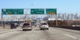
The Central Freeway is a roughly one-mile (1.5 km) elevated freeway in San Francisco, California
, United States
, connecting the Bayshore
/James Lick Freeway (US 101 and I-80) with the Hayes Valley neighborhood. Most of the freeway is part of US 101, which exits at Mission Street
on the way to the Golden Gate Bridge
. The freeway once extended north to Turk Street, and was once proposed to form part of a complete loop around downtown (along with the Embarcadero Freeway), but was damaged in the 1989 Loma Prieta earthquake
and has been replaced with the surface-level Octavia Boulevard
north of Market Street
.
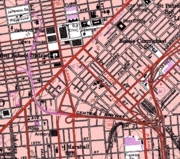
 The Central Freeway begins at a directional "Y" interchange at the west end of Interstate 80 in the South of Market neighborhood, and travels west above Division Street and 13th Street. This interchange also includes access between the Bayshore Freeway
, which carries US 101 to the south, and the one-way pair
of 9th and 10th Streets. As it approaches the end, US 101 exits onto Mission Street
to access Van Ness Avenue, which it follows north to Lombard Street
and the Golden Gate Bridge
. The remainder of the freeway is signed as exit 434B from US 101, and comes to the surface at Market Street
and Octavia Boulevard
, the latter continuing north to Oak and Fell Streets, a one-way pair west to Golden Gate Park
. No traffic from Market Street is allowed to turn onto the freeway, but traffic from the freeway may turn right onto Market. The first opportunity for traffic that instead continues onto the boulevard to leave it is east on Page Street.
Beyond Fell Street, the freeway curved northeast, with the northbound (lower) side ending at a ramp to Golden Gate Avenue and Franklin Street, and the southbound (upper) level touching down to the northwest at Turk and Gough Streets. This land remains mainly undeveloped, filled mostly by parking lot
s.
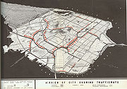 The 1948 Transportation Plan for San Francisco, prepared by De Leuw, Cather and Company, included the Central Freeway. This elevated roadway would begin at the Bayshore Freeway
- the approach to the San Francisco – Oakland Bay Bridge - near Division Street and head west and north around the periphery of downtown San Francisco. This portion would include junctions with the Mission Freeway (south and southwest along Mission Street
to Daly City) at the southwest corner and the Panhandle Freeway (west through the Panhandle
into Golden Gate Park
) along the west side. After swinging northeast and back north to the east side of Van Ness Avenue (continuing as a double-decked structure between Van Ness Ave. and Polk Street
), a pair of ramps would split to the east, taking downtown traffic to and from the one-way pair
of Bush and Pine Streets. At Clay Street, the freeway would descend to meet the rising terrain, ending at Broadway just east of Van Ness Avenue as a single level depressed roadway. A short tunnel
would curve northwest to a portal in Van Ness Avenue north of Broadway, taking traffic onto Van Ness Avenue towards the Golden Gate Bridge
. Along with the Embarcadero and Broadway Tunnel
, which were listed for rebuilding as ground-level expressways
rather than the freeway (Embarcadero Freeway) that was later partially built and demolished, the Central Freeway would have provided a full traffic distributor loop around downtown.
 The route was also included in the 1955 city master plan, by then extending north beyond the former Broadway terminus to the proposed Golden Gate Freeway near Lombard Street
. The first piece, connecting the Bayshore Freeway
with Mission Street
, opened March 1, 1955, at about the same time as the Bayshore. The part of the Central Freeway to the one-way pair
of Golden Gate Avenue and Turk Street opened in April 1959, and became part of U.S. Route 101 (and Legislative Route 2) via this one-way pair to the old route on Van Ness Avenue. In January of that year, as one of the opening events in the freeway revolts, the San Francisco Board of Supervisors
passed Resolution 45-59, removing the remainder of the Central Freeway and most other proposed freeways from the city's highway plan. Interstate 80, which had been assigned to the Central Freeway southeast of the proposed Panhandle Freeway, was truncated by the Federal Highway Administration
in August 1965 and by the state in 1968.
There was a plan promulgated in February 1962 to relieve traffic congestion on the Golden Gate Bridge
by constructing a San Francisco-Tiburon Bridge from Van Ness Ave. at Aquatic Park
in San Francisco north across the Golden Gate Strait to Tiburon
to connect with the Redwood Highway, which would have been anchored on Angel Island. Had this bridge actually been constructed, it would have probably been eventually necessary to construct the proposed northern section of the Central Freeway from Turk Street north to Aquatic Park in order to adequately funnel traffic to it.
The freeway created urban blight in the Hayes Valley neighborhood that it passed through. In 1989, the Loma Prieta earthquake
damaged the northern part of the elevated roadway, and in 1992 Caltrans removed the freeway north of Fell Street. That year the Board of Supervisors banned any new freeway construction north of Market Street
; a city task force recommended its replacement with a surface boulevard
in 1995. Caltrans closed the double-deck freeway north of Mission Street for rebuilding in late 1996. A fight began between the primarily Chinese American
residents of western San Francisco (the Richmond District
and the Sunset District
), who favored the Caltrans plan to rebuild it because it provided easy access for prospective customers to get to their businesses in the Richmond and Sunset districts, and the primarily White
and African American
Hayes Valley local residents, who regarded the freeway as urban blight, and were supported by Mayor Willie Brown
. Caltrans reopened the northbound (lower) deck to Fell Street in 1997, and several initiatives were passed to remove the lower deck. The final compromise took a two-way freeway down to ground level at Market Street, where Octavia Boulevard
- a widened Octavia Street on the former freeway right-of-way — would continue to Fell Street. The completed project opened on September 9, 2005, and has been seen generally as a success. However, the South of Market neighborhood actually got a wider freeway, closer to ground level, in the space where the double-decked road had been.
The entire route is within city limits of San Francisco, California
.
San Francisco, California
San Francisco , officially the City and County of San Francisco, is the financial, cultural, and transportation center of the San Francisco Bay Area, a region of 7.15 million people which includes San Jose and Oakland...
, United States
United States
The United States of America is a federal constitutional republic comprising fifty states and a federal district...
, connecting the Bayshore
Bayshore Freeway
The Bayshore Freeway is a part of U.S. Route 101 in the San Francisco Bay Area of the U.S. state of California. It runs along the west shore of the San Francisco Bay, connecting San Jose with San Francisco. Within the city of San Francisco, the freeway is also known as James Lick Freeway...
/James Lick Freeway (US 101 and I-80) with the Hayes Valley neighborhood. Most of the freeway is part of US 101, which exits at Mission Street
Mission Street
Mission Street is a north-south arterial thoroughfare in San Francisco, California that runs from the city's southern border to its northeast corner. The street and the Mission District through which it runs were named for the Spanish Mission Dolores, several blocks away from the modern route. Only...
on the way to the Golden Gate Bridge
Golden Gate Bridge
The Golden Gate Bridge is a suspension bridge spanning the Golden Gate, the opening of the San Francisco Bay into the Pacific Ocean. As part of both U.S. Route 101 and California State Route 1, the structure links the city of San Francisco, on the northern tip of the San Francisco Peninsula, to...
. The freeway once extended north to Turk Street, and was once proposed to form part of a complete loop around downtown (along with the Embarcadero Freeway), but was damaged in the 1989 Loma Prieta earthquake
Loma Prieta earthquake
The Loma Prieta earthquake, also known as the Quake of '89 and the World Series Earthquake, was a major earthquake that struck the San Francisco Bay Area of California on October 17, 1989, at 5:04 p.m. local time...
and has been replaced with the surface-level Octavia Boulevard
Octavia Boulevard
Octavia Boulevard is a major street in San Francisco, California that replaced the Hayes Valley portion of the damaged two-level Central Freeway. Once a portion of Octavia Street alongside shadowy, fenced-off land beneath the elevated U.S...
north of Market Street
Market Street (San Francisco)
Market Street is an important thoroughfare in San Francisco, California. It begins at The Embarcadero in front of the Ferry Building at the northeastern edge of the city and runs southwest through downtown, passing the Civic Center and the Castro District, to the intersection with Corbett Avenue in...
.
Route description
Bayshore Freeway
The Bayshore Freeway is a part of U.S. Route 101 in the San Francisco Bay Area of the U.S. state of California. It runs along the west shore of the San Francisco Bay, connecting San Jose with San Francisco. Within the city of San Francisco, the freeway is also known as James Lick Freeway...
, which carries US 101 to the south, and the one-way pair
One-way pair
A one-way pair, one-way couple, or just couplet is a pair of parallel, usually one-way streets that carry opposite directions of a signed route or major traffic flow, or sometimes opposite directions of a bus or streetcar route....
of 9th and 10th Streets. As it approaches the end, US 101 exits onto Mission Street
Mission Street
Mission Street is a north-south arterial thoroughfare in San Francisco, California that runs from the city's southern border to its northeast corner. The street and the Mission District through which it runs were named for the Spanish Mission Dolores, several blocks away from the modern route. Only...
to access Van Ness Avenue, which it follows north to Lombard Street
Lombard Street
There are several famous Lombard Streets:* Lombard Street , famed for its twists and turns* Lombard Street, London, leading from the Bank of England to Gracechurch Street...
and the Golden Gate Bridge
Golden Gate Bridge
The Golden Gate Bridge is a suspension bridge spanning the Golden Gate, the opening of the San Francisco Bay into the Pacific Ocean. As part of both U.S. Route 101 and California State Route 1, the structure links the city of San Francisco, on the northern tip of the San Francisco Peninsula, to...
. The remainder of the freeway is signed as exit 434B from US 101, and comes to the surface at Market Street
Market Street (San Francisco)
Market Street is an important thoroughfare in San Francisco, California. It begins at The Embarcadero in front of the Ferry Building at the northeastern edge of the city and runs southwest through downtown, passing the Civic Center and the Castro District, to the intersection with Corbett Avenue in...
and Octavia Boulevard
Octavia Boulevard
Octavia Boulevard is a major street in San Francisco, California that replaced the Hayes Valley portion of the damaged two-level Central Freeway. Once a portion of Octavia Street alongside shadowy, fenced-off land beneath the elevated U.S...
, the latter continuing north to Oak and Fell Streets, a one-way pair west to Golden Gate Park
Golden Gate Park
Golden Gate Park, located in San Francisco, California, is a large urban park consisting of of public grounds. Configured as a rectangle, it is similar in shape but 20% larger than Central Park in New York, to which it is often compared. It is over three miles long east to west, and about half a...
. No traffic from Market Street is allowed to turn onto the freeway, but traffic from the freeway may turn right onto Market. The first opportunity for traffic that instead continues onto the boulevard to leave it is east on Page Street.
Beyond Fell Street, the freeway curved northeast, with the northbound (lower) side ending at a ramp to Golden Gate Avenue and Franklin Street, and the southbound (upper) level touching down to the northwest at Turk and Gough Streets. This land remains mainly undeveloped, filled mostly by parking lot
Parking lot
A parking lot , also known as car lot, is a cleared area that is intended for parking vehicles. Usually, the term refers to a dedicated area that has been provided with a durable or semi-durable surface....
s.
History
Bayshore Freeway
The Bayshore Freeway is a part of U.S. Route 101 in the San Francisco Bay Area of the U.S. state of California. It runs along the west shore of the San Francisco Bay, connecting San Jose with San Francisco. Within the city of San Francisco, the freeway is also known as James Lick Freeway...
- the approach to the San Francisco – Oakland Bay Bridge - near Division Street and head west and north around the periphery of downtown San Francisco. This portion would include junctions with the Mission Freeway (south and southwest along Mission Street
Mission Street
Mission Street is a north-south arterial thoroughfare in San Francisco, California that runs from the city's southern border to its northeast corner. The street and the Mission District through which it runs were named for the Spanish Mission Dolores, several blocks away from the modern route. Only...
to Daly City) at the southwest corner and the Panhandle Freeway (west through the Panhandle
Panhandle (San Francisco)
The Panhandle is a park in San Francisco, California that forms a panhandle with Golden Gate Park. It is long and narrow, being three-quarters of a mile long and one block wide. Fell Street borders it to the north, Oak Street to the south, and Baker Street to the east. The Haight-Ashbury District...
into Golden Gate Park
Golden Gate Park
Golden Gate Park, located in San Francisco, California, is a large urban park consisting of of public grounds. Configured as a rectangle, it is similar in shape but 20% larger than Central Park in New York, to which it is often compared. It is over three miles long east to west, and about half a...
) along the west side. After swinging northeast and back north to the east side of Van Ness Avenue (continuing as a double-decked structure between Van Ness Ave. and Polk Street
Polk Street
Polk Street is a street in San Francisco, California, that travels northward from Market Street to Beach Street and is one of the main thoroughfares of the Polk Gulch neighborhood traversing through the Tenderloin, Nob Hill, and Russian Hill neighborhoods. The street takes its name from former U.S....
), a pair of ramps would split to the east, taking downtown traffic to and from the one-way pair
One-way pair
A one-way pair, one-way couple, or just couplet is a pair of parallel, usually one-way streets that carry opposite directions of a signed route or major traffic flow, or sometimes opposite directions of a bus or streetcar route....
of Bush and Pine Streets. At Clay Street, the freeway would descend to meet the rising terrain, ending at Broadway just east of Van Ness Avenue as a single level depressed roadway. A short tunnel
Tunnel
A tunnel is an underground passageway, completely enclosed except for openings for egress, commonly at each end.A tunnel may be for foot or vehicular road traffic, for rail traffic, or for a canal. Some tunnels are aqueducts to supply water for consumption or for hydroelectric stations or are sewers...
would curve northwest to a portal in Van Ness Avenue north of Broadway, taking traffic onto Van Ness Avenue towards the Golden Gate Bridge
Golden Gate Bridge
The Golden Gate Bridge is a suspension bridge spanning the Golden Gate, the opening of the San Francisco Bay into the Pacific Ocean. As part of both U.S. Route 101 and California State Route 1, the structure links the city of San Francisco, on the northern tip of the San Francisco Peninsula, to...
. Along with the Embarcadero and Broadway Tunnel
Broadway Tunnel (San Francisco)
The Broadway Tunnel is a roadway tunnel in San Francisco, California. The tunnel opened in 1952, and serves as a high-capacity conduit for traffic between Chinatown and North Beach in the east and Russian Hill and Van Ness in the west...
, which were listed for rebuilding as ground-level expressways
Limited-access road
A limited-access road known by various terms worldwide, including limited-access highway, dual-carriageway and expressway, is a highway or arterial road for high-speed traffic which has many or most characteristics of a controlled-access highway , including limited or no access to adjacent...
rather than the freeway (Embarcadero Freeway) that was later partially built and demolished, the Central Freeway would have provided a full traffic distributor loop around downtown.
Lombard Street (San Francisco)
Lombard Street is an east–west street in San Francisco, California. It is famous for having a steep, one-block section that consists of eight tight hairpin turns.-Route description:...
. The first piece, connecting the Bayshore Freeway
Bayshore Freeway
The Bayshore Freeway is a part of U.S. Route 101 in the San Francisco Bay Area of the U.S. state of California. It runs along the west shore of the San Francisco Bay, connecting San Jose with San Francisco. Within the city of San Francisco, the freeway is also known as James Lick Freeway...
with Mission Street
Mission Street
Mission Street is a north-south arterial thoroughfare in San Francisco, California that runs from the city's southern border to its northeast corner. The street and the Mission District through which it runs were named for the Spanish Mission Dolores, several blocks away from the modern route. Only...
, opened March 1, 1955, at about the same time as the Bayshore. The part of the Central Freeway to the one-way pair
One-way pair
A one-way pair, one-way couple, or just couplet is a pair of parallel, usually one-way streets that carry opposite directions of a signed route or major traffic flow, or sometimes opposite directions of a bus or streetcar route....
of Golden Gate Avenue and Turk Street opened in April 1959, and became part of U.S. Route 101 (and Legislative Route 2) via this one-way pair to the old route on Van Ness Avenue. In January of that year, as one of the opening events in the freeway revolts, the San Francisco Board of Supervisors
San Francisco Board of Supervisors
The San Francisco Board of Supervisors is the legislative body within the government of the City and County of San Francisco, California, United States.-Government and politics:...
passed Resolution 45-59, removing the remainder of the Central Freeway and most other proposed freeways from the city's highway plan. Interstate 80, which had been assigned to the Central Freeway southeast of the proposed Panhandle Freeway, was truncated by the Federal Highway Administration
Federal Highway Administration
The Federal Highway Administration is a division of the United States Department of Transportation that specializes in highway transportation. The agency's major activities are grouped into two "programs," the Federal-aid Highway Program and the Federal Lands Highway Program...
in August 1965 and by the state in 1968.
There was a plan promulgated in February 1962 to relieve traffic congestion on the Golden Gate Bridge
Golden Gate Bridge
The Golden Gate Bridge is a suspension bridge spanning the Golden Gate, the opening of the San Francisco Bay into the Pacific Ocean. As part of both U.S. Route 101 and California State Route 1, the structure links the city of San Francisco, on the northern tip of the San Francisco Peninsula, to...
by constructing a San Francisco-Tiburon Bridge from Van Ness Ave. at Aquatic Park
Aquatic Park Historic District
Aquatic Park Historic District is a building complex on the San Francisco Bay waterfront in San Francisco, California, United States. It is located within San Francisco Maritime National Historical Park and is itself a National Historic Landmark....
in San Francisco north across the Golden Gate Strait to Tiburon
Tiburon, California
Tiburon is an incorporated town in Marin County, California. It occupies most of the Tiburon Peninsula, which reaches south into the San Francisco Bay. The smaller city of Belvedere occupies the south-east part of the peninsula and is contiguous with Tiburon...
to connect with the Redwood Highway, which would have been anchored on Angel Island. Had this bridge actually been constructed, it would have probably been eventually necessary to construct the proposed northern section of the Central Freeway from Turk Street north to Aquatic Park in order to adequately funnel traffic to it.
The freeway created urban blight in the Hayes Valley neighborhood that it passed through. In 1989, the Loma Prieta earthquake
Loma Prieta earthquake
The Loma Prieta earthquake, also known as the Quake of '89 and the World Series Earthquake, was a major earthquake that struck the San Francisco Bay Area of California on October 17, 1989, at 5:04 p.m. local time...
damaged the northern part of the elevated roadway, and in 1992 Caltrans removed the freeway north of Fell Street. That year the Board of Supervisors banned any new freeway construction north of Market Street
Market Street (San Francisco)
Market Street is an important thoroughfare in San Francisco, California. It begins at The Embarcadero in front of the Ferry Building at the northeastern edge of the city and runs southwest through downtown, passing the Civic Center and the Castro District, to the intersection with Corbett Avenue in...
; a city task force recommended its replacement with a surface boulevard
Boulevard
A Boulevard is type of road, usually a wide, multi-lane arterial thoroughfare, divided with a median down the centre, and roadways along each side designed as slow travel and parking lanes and for bicycle and pedestrian usage, often with an above-average quality of landscaping and scenery...
in 1995. Caltrans closed the double-deck freeway north of Mission Street for rebuilding in late 1996. A fight began between the primarily Chinese American
Chinese American
Chinese Americans represent Americans of Chinese descent. Chinese Americans constitute one group of overseas Chinese and also a subgroup of East Asian Americans, which is further a subgroup of Asian Americans...
residents of western San Francisco (the Richmond District
Richmond District, San Francisco, California
The Richmond District is a neighborhood in the northwest corner of San Francisco, California.-Location:Lying directly north of Golden Gate Park, "the Richmond" is bounded roughly by Fulton Street to the south, Arguello Boulevard and Laurel Heights to the east, The Presidio National Park and Lincoln...
and the Sunset District
Sunset District, San Francisco, California
The Sunset District is a large neighborhood in the west-central part of San Francisco, California, United States.-Location:The Sunset District is the largest district within the city of San Francisco. Golden Gate Park forms the neighborhood's northern border, and the Pacific Ocean forms its...
), who favored the Caltrans plan to rebuild it because it provided easy access for prospective customers to get to their businesses in the Richmond and Sunset districts, and the primarily White
White people
White people is a term which usually refers to human beings characterized, at least in part, by the light pigmentation of their skin...
and African American
African American
African Americans are citizens or residents of the United States who have at least partial ancestry from any of the native populations of Sub-Saharan Africa and are the direct descendants of enslaved Africans within the boundaries of the present United States...
Hayes Valley local residents, who regarded the freeway as urban blight, and were supported by Mayor Willie Brown
Willie Brown (politician)
Willie Lewis Brown, Jr. is an American politician of the Democratic Party. He served over 30 years in the California State Assembly, spending 15 years as its Speaker, and afterward served as the 41st mayor of San Francisco, the first African American to do so...
. Caltrans reopened the northbound (lower) deck to Fell Street in 1997, and several initiatives were passed to remove the lower deck. The final compromise took a two-way freeway down to ground level at Market Street, where Octavia Boulevard
Octavia Boulevard
Octavia Boulevard is a major street in San Francisco, California that replaced the Hayes Valley portion of the damaged two-level Central Freeway. Once a portion of Octavia Street alongside shadowy, fenced-off land beneath the elevated U.S...
- a widened Octavia Street on the former freeway right-of-way — would continue to Fell Street. The completed project opened on September 9, 2005, and has been seen generally as a success. However, the South of Market neighborhood actually got a wider freeway, closer to ground level, in the space where the double-decked road had been.
Exit list
- Note: Except where prefixed with a letter, postmiles were measured in 1964, based on the alignment as it existed at that time, and do not necessarily reflect current mileage.
The entire route is within city limits of San Francisco, California
California
California is a state located on the West Coast of the United States. It is by far the most populous U.S. state, and the third-largest by land area...
.
| Postmile |
# Exit number An exit number is a number assigned to a road junction, usually an exit from a freeway. It is usually marked on the same sign as the destinations of the exit, as well as a sign in the gore.... |
Destinations | Notes |
|---|---|---|---|
| R4.24 | 433B | Signed as exit 433 southbound | |
| 433C | Ninth Street – Civic Center | Northbound exit and southbound entrance | |
| Northbound exit and southbound entrance | |||
| 434A | Duboce Avenue | Northbound exit and southbound entrance | |
| Market Street Market Street (San Francisco) Market Street is an important thoroughfare in San Francisco, California. It begins at The Embarcadero in front of the Ferry Building at the northeastern edge of the city and runs southwest through downtown, passing the Civic Center and the Castro District, to the intersection with Corbett Avenue in... |
At-grade intersection At-grade intersection An at-grade intersection is a junction at which two or more transport axes cross at the same level .-Traffic management:With areas of high or fast traffic, an at-grade intersection normally requires a traffic control device such as a stop sign, traffic light or railway signal to manage conflicting... ; only right turns onto Market Street are allowed |
||
| 434B | Octavia Boulevard Octavia Boulevard Octavia Boulevard is a major street in San Francisco, California that replaced the Hayes Valley portion of the damaged two-level Central Freeway. Once a portion of Octavia Street alongside shadowy, fenced-off land beneath the elevated U.S... to Fell Street |
Continuation beyond Market Street | |
| Former continuation beyond Mission Street / Duboce Avenue | |||
| Oak Street | Southbound entrance only (Closed in 1996) | ||
| Fell Street | Northbound exit only (Closed in 2003) | ||
| Golden Gate Avenue, Franklin Street | Northbound exit only (Closed in 1989) | ||
| Gough Street, Turk Street | Southbound entrance only (Closed in 1989) | ||
External links
- Timeline: A look back at Octavia St. and the Central Freeway
- California Highways: US 101
- California Highways (www.cahighways.org) San Francisco-Bay Area Freeway Development (Part 1—The City of San Francisco)
- Plans from 1948 for the extension of the Central Freeway north to Broadway
- Map from 1957 of the connection of the proposed San Francisco-Tiburon Crossing to the Central Freeway