

Control city
Encyclopedia
Traffic sign
Traffic signs or road signs are signs erected at the side of roads to provide information to road users. With traffic volumes increasing over the last eight decades, many countries have adopted pictorial signs or otherwise simplified and standardized their signs to facilitate international travel...
indicating forward destinations on a certain route. These destinations aid motorists using the highway system to reach destinations along the various routes. Such cities appear on signs at highway junctions to indicate where the intersecting road goes, or on mileage signs on longer routes.
United States
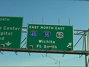
The Manual on Uniform Traffic Control Devices (MUTCD) states that control cities should be used:- At interchanges between freeways (example US-1 in gallery)
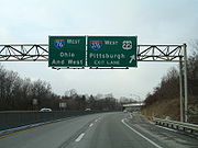
- At separation points of overlapping freeway routes (example US-2 in gallery)
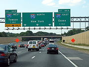
- On directional signs on intersecting routes, to guide traffic entering the freeway (example US-3 in gallery)
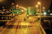
- On pull-through signs (example US-4 in gallery)
- On the bottom line of post-interchange distance signs (example US-5 in gallery)
The individual states ultimately have the authority to decide which cities can be control cities, but the American Association of State Highway and Transportation Officials
American Association of State Highway and Transportation Officials
AASHTO, the American Association of State Highway and Transportation Officials, is a standards setting body which publishes specifications, test protocols and guidelines which are used in highway design and construction throughout the United States...
retains the authority to approve the official list and standardizes all control cities used on the Interstate Highway system in the United States
United States
The United States of America is a federal constitutional republic comprising fifty states and a federal district...
. The published standard is not always followed, for a few reasons – major destinations have since appeared that were not on the original list, new roads have been built that provide new routes, or because of state highway departments' hesitancy to sign destinations in other states. Some examples:

- On eastbound Interstate 10Interstate 10Interstate 10 is the fourth-longest Interstate Highway in the United States, after I-90, I-80, and I-40. It is the southernmost east–west, coast-to-coast Interstate Highway, although I-4 and I-8 are further south. It stretches from the Pacific Ocean at State Route 1 in Santa Monica,...
near Palm Springs, CaliforniaPalm Springs, CaliforniaPalm Springs is a desert city in Riverside County, California, within the Coachella Valley. It is located approximately 37 miles east of San Bernardino, 111 miles east of Los Angeles and 136 miles northeast of San Diego...
, Caltrans uses the small city of Indio, CaliforniaIndio, CaliforniaIndio is a city in Riverside County, California, United States, located in the Coachella Valley of Southern California's Colorado Desert region. It lies east of Palm Springs, east of Riverside, and east of Los Angeles. It is about north of Mexicali, Baja California on the U.S.-Mexican border...
, and , though Phoenix, ArizonaPhoenix, ArizonaPhoenix is the capital, and largest city, of the U.S. state of Arizona, as well as the sixth most populated city in the United States. Phoenix is home to 1,445,632 people according to the official 2010 U.S. Census Bureau data...
is the nearest major forward destination. This inspired the title of a play by Jon Robin BaitzJon Robin BaitzJon Robin Baitz is an American playwright, screenwriter, television producer and sometime actor.-Life and career:Baitz was born in Los Angeles, California, the son of Edward Baitz, an executive of the Carnation Company. Baitz was raised in Brazil and South Africa before the family returned to...
, Other Desert Cities. - Sometimes, the opposite is true. In Washington state, Vancouver, British Columbia (signed "Vancouver B.C." to prevent confusion with Vancouver, Washington, which the same interstate goes through but in the opposite direction) is the control city for northbound Interstate 5Interstate 5Interstate 5 is the main Interstate Highway on the West Coast of the United States, running largely parallel to the Pacific Ocean coastline from Canada to Mexico . It serves some of the largest cities on the U.S...
north of Seattle, which is reached via British Columbia Highway 99. Similarly, MontrealMontrealMontreal is a city in Canada. It is the largest city in the province of Quebec, the second-largest city in Canada and the seventh largest in North America...
is the control city for Interstate 87Interstate 87Interstate 87 is a Interstate Highway located entirely within New York State in the United States of America. I-87 is the longest intrastate Interstate highway in the Interstate Highway System. Its southern end is at the Bronx approaches of the Robert F. Kennedy Bridge in New York City...
north of AlbanyAlbany, New YorkAlbany is the capital city of the U.S. state of New York, the seat of Albany County, and the central city of New York's Capital District. Roughly north of New York City, Albany sits on the west bank of the Hudson River, about south of its confluence with the Mohawk River...
. - Interstate 40Interstate 40 in ArizonaInterstate 40 is an east–west Interstate Highway that has a section in the U.S. state of Arizona connecting sections in California to New Mexico. It enters Arizona from the west at a crossing of the Colorado River southwest of Kingman...
uses Los AngelesLos ÁngelesLos Ángeles is the capital of the province of Biobío, in the commune of the same name, in Region VIII , in the center-south of Chile. It is located between the Laja and Biobío rivers. The population is 123,445 inhabitants...
as a control city for motorists west of FlagstaffFlagstaff, ArizonaFlagstaff is a city located in northern Arizona, in the southwestern United States. In 2010, the city's population was 65,870. The population of the Metropolitan Statistical Area was at 134,421 in 2010. It is the county seat of Coconino County...
, even though I-40 does not reach Los Angeles, and neither does Interstate 15Interstate 15 in CaliforniaIn the U.S. state of California, Interstate 15 is a major north–south route through the San Bernardino, Riverside, and San Diego Counties, and it has a length of in the state. It is a major thoroughfare for traffic between Southern California and Las Vegas, Nevada, as well as points beyond...
, which is at its western terminus. - Interstate 57Interstate 57Interstate 57 is an Interstate Highway in Missouri and Illinois that parallels the old Illinois Central rail line for much of its route. It goes from Miner, Missouri, at Interstate 55 to Chicago, Illinois, at Interstate 94. I-57 essentially serves as a shortcut route for travelers headed between...
uses MemphisMemphis, TennesseeMemphis is a city in the southwestern corner of the U.S. state of Tennessee, and the county seat of Shelby County. The city is located on the 4th Chickasaw Bluff, south of the confluence of the Wolf and Mississippi rivers....
as a control city for southbound motorists, even though the expressway does not reach Memphis or even enter the state of Tennessee; it ends near Sikeston, Missouri, 150 miles (241.4 km) to the north. The use of Memphis derives from Interstate 57 serving as an alternative to Interstate 55Interstate 55Interstate 55 is an Interstate Highway in the central United States. Its odd number indicates that it is a north–south Interstate Highway. I-55 goes from LaPlace, Louisiana at Interstate 10 to Chicago at U.S. Route 41 , at McCormick Place. A common nickname for the highway is "double...
, which passes through the city. - On Interstate 85 in North CarolinaInterstate 85 in North CarolinaIn the U.S. state of North Carolina, Interstate 85 scales the state for from the South Carolina border to the Virginia border. As the second-longest interstate in the state , it provides an important link between the cities of Atlanta, Georgia, Charlotte, Greensboro, Richmond, Virginia and...
, NCDOT uses Richmond, VirginiaRichmond, VirginiaRichmond is the capital of the Commonwealth of Virginia, in the United States. It is an independent city and not part of any county. Richmond is the center of the Richmond Metropolitan Statistical Area and the Greater Richmond area...
as the control city even though it terminates at I-95 in Petersburg, VirginiaPetersburg, VirginiaPetersburg is an independent city in Virginia, United States located on the Appomattox River and south of the state capital city of Richmond. The city's population was 32,420 as of 2010, predominantly of African-American ethnicity...
, 20 miles (32.2 km) south of Richmond. VDOTVirginia Department of TransportationThe Virginia Department of Transportation is the agency of state government responsible for transportation in the state of Virginia in the United States. Headquartered in Downtown Richmond, VDOT is responsible for building, maintaining, and operating the roads, bridges and tunnels in the...
uses Petersburg. - On Interstate 65Interstate 65 in IndianaIn the U.S. state of Indiana, Interstate 65 traverses the state from south to north. The Indiana portion begins near Louisville, Kentucky and travels north, passing through Columbus, Indianapolis, Lafayette. Interstate 65 terminates near Gary on the Indiana Toll Road. Interstate 65 covers 261.27...
, heading north out of IndianapolisIndianapolisIndianapolis is the capital of the U.S. state of Indiana, and the county seat of Marion County, Indiana. As of the 2010 United States Census, the city's population is 839,489. It is by far Indiana's largest city and, as of the 2010 U.S...
, INDOT uses ChicagoChicagoChicago is the largest city in the US state of Illinois. With nearly 2.7 million residents, it is the most populous city in the Midwestern United States and the third most populous in the US, after New York City and Los Angeles...
as the control city though I-65 terminates at Gary, IndianaGary, IndianaGary is a city in Lake County, Indiana, United States. The city is in the southeastern portion of the Chicago metropolitan area and is 25 miles from downtown Chicago. The population is 80,294 at the 2010 census, making it the seventh-largest city in the state. It borders Lake Michigan and is known...
, 17 miles (27.4 km) south of Chicago. - On Interstate 515Interstate 515Interstate 515 is a spur of Interstate 15 that runs from the junction of I-15, US 93 and US 95 near Downtown Las Vegas, Nevada approximately southeast to Railroad Pass near the borders of Henderson and Boulder City....
in Las VegasLas Vegas, NevadaLas Vegas is the most populous city in the U.S. state of Nevada and is also the county seat of Clark County, Nevada. Las Vegas is an internationally renowned major resort city for gambling, shopping, and fine dining. The city bills itself as The Entertainment Capital of the World, and is famous...
, the Nevada Department of TransportationNevada Department of TransportationThe Nevada Department of Transportation is a government agency in the U.S. state of Nevada. NDOT is responsible for maintaining and improving Nevada's highway system, which includes U.S. highways and Interstate highways within the state's boundaries. The department is notable for its...
(NDOT) uses Phoenix as the control city, though I-515 terminates in southeast suburban HendersonHenderson, Nevada-Demographics:According to the 2000 census, there were 175,381 people, 66,331 households, and 47,095 families residing in the city. The population density was 2,200.8 people per square mile . There were 71,149 housing units at an average density of 892.8 per square mile...
. I-515 runs concurrently with US 93U.S. Route 93 in NevadaIn the U.S. state of Nevada, U.S. Route 93 is a major U.S. highway traversing the eastern edge of the state. The highway connects the Las Vegas area to the Great Basin National Park, and provides further connections to Ely and Wells...
and US 95U.S. Route 95 in NevadaIn the U.S. state of Nevada, U.S. Route 95 is a major U.S. highway traversing the state from north to south directly through Las Vegas and providing connections to both Carson City and Reno...
along its entire length; traffic continues into the state of Arizona on non-Interstate-standard alignments of US 93 (with the US 93 portion crossing the Arizona state line over the Mike O'Callaghan – Pat Tillman Memorial Bridge, while the US 95 portion splits off just outside Henderson and Boulder CityBoulder City, NevadaBoulder City is a city in Clark County, Nevada, United States. It is approximately from the City of Las Vegas. As of the 2010 census the population of Boulder City was 15,023.Boulder City is one of only two cities in Nevada that prohibit gambling....
and heads south towards SearchlightSearchlight, NevadaSearchlight is an unincorporated town in Clark County, Nevada, at the topographic saddle between two mountain ranges.-History:According to Nevada Senator Harry Reid, who has written extensively about his hometown, the most likely story as to how the town received its name was when George Frederick...
and Cal-Nev-AriCal-Nev-Ari, NevadaCal-Nev-Ari is a census-designated place and town in Clark County, Nevada, United States, near the state's southernmost point. As of the 2000 census, the town had a total population of 278...
, entering the state of California near NeedlesNeedles, CaliforniaNeedles is a city located in the Mojave Desert on the western banks of the Colorado River in San Bernardino County, California. It is located in the Mohave Valley, which straddles the California–Arizona border. The city is accessible via Interstate 40 and U.S. Route 95...
, where it merges with I-40Interstate 40 in CaliforniaIn the U.S. state of California, Interstate 40 has its western terminus in Barstow. Known as the Needles Freeway, a major east–west route of the Interstate Highway System, it heads east from Barstow across the Mojave Desert in San Bernardino County past the Clipper Mountains to Needles,...
). US 93 does not reach all the way to Phoenix, its southern terminus coming at a junction with US 60U.S. Route 60 in ArizonaU.S. Route 60 is an east–west United States highway within Arizona. The highway runs for from a junction with Interstate 10 near Quartzsite to the New Mexico State Line near Springerville...
in the town of WickenburgWickenburg, ArizonaWickenburg is a town in Maricopa County, Arizona, United States. According to 2006 Census Bureau estimates, the population of the town is 6,423.-Geography:Wickenburg is located at ....
, about 50 miles (80.5 km) northwest of Phoenix; southbound traffic into the Phoenix area continues on US 60 east.
A control city is not always a major city. For instance:
- Interstate 10Interstate 10Interstate 10 is the fourth-longest Interstate Highway in the United States, after I-90, I-80, and I-40. It is the southernmost east–west, coast-to-coast Interstate Highway, although I-4 and I-8 are further south. It stretches from the Pacific Ocean at State Route 1 in Santa Monica,...
heading eastbound in El PasoEl Paso, TexasEl Paso, is a city in and the county seat of El Paso County, Texas, United States, and lies in far West Texas. In the 2010 census, the city had a population of 649,121. It is the sixth largest city in Texas and the 19th largest city in the United States...
uses Van Horn, TexasVan Horn, TexasVan Horn is a town in and the county seat of Culberson County, Texas, United States. The population was 2,435 at the 2000 census.-Geography:Van Horn is located at ....
, a small city west of the western terminus of I-20. - Interstate 10Interstate 10Interstate 10 is the fourth-longest Interstate Highway in the United States, after I-90, I-80, and I-40. It is the southernmost east–west, coast-to-coast Interstate Highway, although I-4 and I-8 are further south. It stretches from the Pacific Ocean at State Route 1 in Santa Monica,...
heading eastbound out of New OrleansNew Orleans, LouisianaNew Orleans is a major United States port and the largest city and metropolitan area in the state of Louisiana. The New Orleans metropolitan area has a population of 1,235,650 as of 2009, the 46th largest in the USA. The New Orleans – Metairie – Bogalusa combined statistical area has a population...
uses SlidellSlidell, LouisianaSlidell is a city situated on the northeast shore of Lake Pontchartrain in St. Tammany Parish, Louisiana, United States. The population was 25,695 at the 2000 census. The Greater Slidell Community has a population of about 90,000...
, a small city near I-12 and I-59's terminus. - Interstate 10Interstate 10Interstate 10 is the fourth-longest Interstate Highway in the United States, after I-90, I-80, and I-40. It is the southernmost east–west, coast-to-coast Interstate Highway, although I-4 and I-8 are further south. It stretches from the Pacific Ocean at State Route 1 in Santa Monica,...
heading eastbound out of SlidellSlidell, LouisianaSlidell is a city situated on the northeast shore of Lake Pontchartrain in St. Tammany Parish, Louisiana, United States. The population was 25,695 at the 2000 census. The Greater Slidell Community has a population of about 90,000...
uses Bay St. LouisBay St. Louis, MississippiBay Saint Louis is a city located in Hancock County, Mississippi. It is part of the Gulfport–Biloxi, Mississippi Metropolitan Statistical Area. As of the 2000 census, the city had a total population of 8,209. It is the county seat of Hancock County...
, a small city west of Gulfport, MississippiGulfport, MississippiGulfport is the second largest city in Mississippi after the state capital Jackson. It is the larger of the two principal cities of the Gulfport-Biloxi, Mississippi Metropolitan Statistical Area, which is included in the Gulfport-Biloxi-Pascagoula, Mississippi Combined Statistical Area. As of the...
. - Interstate 10Interstate 10 in FloridaThe of Interstate 10 in Florida is the eastern most section of the east–west Interstate 10 in the Southern United States. It is also the eastern end of the Interstate Highway known as the Christopher Columbus Transcontinental Highway, one of three coast to coast interstates, along with I-80...
heading eastbound out of TallahasseeTallahassee, FloridaTallahassee is the capital of the U.S. state of Florida. It is the county seat and only incorporated municipality in Leon County, and is the 128th largest city in the United States. Tallahassee became the capital of Florida, then the Florida Territory, in 1824. In 2010, the population recorded by...
and westbound out of JacksonvilleJacksonville, FloridaJacksonville is the largest city in the U.S. state of Florida in terms of both population and land area, and the largest city by area in the contiguous United States. It is the county seat of Duval County, with which the city government consolidated in 1968...
, as well as Interstate 75Interstate 75Interstate 75 is a major north–south Interstate Highway in the Great Lakes and Southeastern regions of the United States. It travels from State Road 826 and State Road 924 in Hialeah, Florida to Sault Ste. Marie, Michigan, at the Ontario, Canada, border...
heading northbound out of OcalaOcala, FloridaOcala is a city in Marion County, Florida. As of 2007, the population recorded by the U.S. Census Bureau was 53,491. It is the county seat of Marion County, and the principal city of the Ocala, Florida Metropolitan Statistical Area, which had an estimated 2007 population of 324,857.-History:Ocala...
and southbound out of ValdostaValdosta, GeorgiaValdosta is the county seat of Lowndes County, Georgia, United States. It is the principal city of the Valdosta Metropolitan Statistical Area. As of the 2010 Census, the city had a total population of 54,518. The Valdosta metropolitan area, according to the 2010 estimate, has a population of 139,588...
, uses Lake CityLake City, FloridaLake City is the county seat of Columbia County, Florida, in the United States. In 2009, the U.S. Census Bureau estimated the city's population at 12,614. In addition, it is the Principal City of the Lake City Micropolitan Statistical Area, which is composed of Columbia County, and had an...
, a small city near where the two highways intersect. - Interstate 12Interstate 12Interstate 12 is an intrastate Interstate Highway located entirely within the state of Louisiana. I-12 starts in Baton Rouge at Interstate 10, and travels along the North Shore of Lake Pontchartrain before ending at the intersection of Interstate 10 and Interstate 59 near Slidell...
uses HammondHammond, LouisianaHammond is the largest city in Tangipahoa Parish, Louisiana, United States. The population was 20,049 at the 2009 census. It is home to Southeastern Louisiana University...
where it crosses I-55 and SlidellSlidell, LouisianaSlidell is a city situated on the northeast shore of Lake Pontchartrain in St. Tammany Parish, Louisiana, United States. The population was 25,695 at the 2000 census. The Greater Slidell Community has a population of about 90,000...
a small city at the highway's terminus at I-10 and I-59's southern terminus. - Interstate 35Interstate 35Interstate 35 is a north–south Interstate Highway in the central United States. I-35 stretches from Laredo, Texas, on the U.S.-Mexico border to Duluth, Minnesota, at Minnesota Highway 61 and 26th Avenue East. Many interstates used to have splits or spurs indicated with suffixed letters , but I-35...
heading south out of the Twin CitiesTwin citiesTwin cities are a special case of two cities or urban centres which are founded in close geographic proximity and then grow into each other over time...
uses Albert LeaAlbert Lea, MinnesotaAlbert Lea is a city in and the county seat of Freeborn County in the southeastern part of the U.S. state of Minnesota. The population was 18,016 at the 2010 census....
, the last town before the Iowa border, and where I-35 intersects with I-90. - Interstate 40Interstate 40Interstate 40 is the third-longest major east–west Interstate Highway in the United States, after I-90 and I-80. Its western end is at Interstate 15 in Barstow, California; its eastern end is at a concurrency of U.S. Route 117 and North Carolina Highway 132 in Wilmington, North Carolina...
between Raleigh and Wilmington, North Carolina, uses BensonBenson, North CarolinaBenson is a town located in Johnston County, North Carolina. The town lies at the intersection of Interstates 95 and 40. Each year Benson celebrates Mule Days the 4th Saturday of September, a festival that attracts over 60,000 people each year...
, the town near which it intersects I-95Interstate 95Interstate 95 is the main highway on the East Coast of the United States, running parallel to the Atlantic Ocean from Maine to Florida and serving some of the most populated urban areas in the country, including Boston, Providence, New Haven, New York City, Newark, Philadelphia, Baltimore,... - Interstate 55Interstate 55Interstate 55 is an Interstate Highway in the central United States. Its odd number indicates that it is a north–south Interstate Highway. I-55 goes from LaPlace, Louisiana at Interstate 10 to Chicago at U.S. Route 41 , at McCormick Place. A common nickname for the highway is "double...
heading northbound out of LaPlaceLaplace, LouisianaLaPlace is a census-designated place in St. John the Baptist Parish, Louisiana, United States, along the east bank of the Mississippi River in the New Orleans metropolitan area. The population is 32,134 at the 2010 census....
uses HammondHammond, LouisianaHammond is the largest city in Tangipahoa Parish, Louisiana, United States. The population was 20,049 at the 2009 census. It is home to Southeastern Louisiana University...
, where it crosses I-12. - Interstate 64Interstate 64Interstate 64 is an Interstate Highway in the Midwestern and Southeastern United States. Its western terminus is at I-70, U.S. 40, and U.S. 61 in Wentzville, Missouri. Its eastern terminus is at an interchange with I-264 and I-664 at Bowers Hill in Chesapeake, Virginia. As I-64 is concurrent with...
heading eastbound out of St. LouisSt. Louis, MissouriSt. Louis is an independent city on the eastern border of Missouri, United States. With a population of 319,294, it was the 58th-largest U.S. city at the 2010 U.S. Census. The Greater St...
uses Mount VernonMount Vernon, IllinoisMount Vernon is a city located near the center of Jefferson County, Illinois, in the United States. In the 2010 census, the city's reported population was 15,277 people.... - Interstate 66Interstate 66Interstate 66 is an Interstate Highway in the eastern United States. As indicated by its even route number, it runs in an east–west direction. Its western terminus is at Middletown, Virginia, at an intersection with Interstate 81; its eastern terminus is in Washington, D.C., at an...
heading westbound out of Washington, D.C.Washington, D.C.Washington, D.C., formally the District of Columbia and commonly referred to as Washington, "the District", or simply D.C., is the capital of the United States. On July 16, 1790, the United States Congress approved the creation of a permanent national capital as permitted by the U.S. Constitution....
uses Front RoyalFront Royal, VirginiaFront Royal is a town in Warren County, Virginia, United States. The population was 13,589 at the 2000 census. It is the county seat of Warren County.-Geography:Front Royal is roughly west of Washington, D.C....
, a small city near the highway's terminus of Strasburg, VirginiaStrasburg, VirginiaStrasburg is a town in Shenandoah County, Virginia, United States, which was founded in 1761 by Peter Stover. It is the largest town, population-wise, in the county and is known for its pottery, antiques, and Civil War history...
. - Interstate 75Interstate 75Interstate 75 is a major north–south Interstate Highway in the Great Lakes and Southeastern regions of the United States. It travels from State Road 826 and State Road 924 in Hialeah, Florida to Sault Ste. Marie, Michigan, at the Ontario, Canada, border...
heading northbound out of Bay City, MichiganBay City, MichiganBay City is a city in the U.S. state of Michigan located near the base of the Saginaw Bay on Lake Huron. As of the 2010 census, the city's population was 34,932, and is the principal city of the Bay City Metropolitan Statistical Area, which is included in the Saginaw-Bay City-Saginaw Township North...
uses the Mackinac BridgeMackinac BridgeThe Mackinac Bridge is a suspension bridge spanning the Straits of Mackinac to connect the non-contiguous Upper and Lower peninsulas of the U.S. state of Michigan. Opened in 1957, the bridge is the third longest in total suspension in the world and the longest suspension bridge between anchorages...
(nearly 200 miles (321.9 km) away) as a control city because there are no large cities north along the highway. - Interstate 76Interstate 76 (east)Interstate 76 is an Interstate Highway in the United States, running 435 miles from an interchange with Interstate 71 west of Akron, Ohio, east to Interstate 295 near Camden, New Jersey....
heading westbound out of Philadelphia, PennsylvaniaPhiladelphia, PennsylvaniaPhiladelphia is the largest city in the Commonwealth of Pennsylvania and the county seat of Philadelphia County, with which it is coterminous. The city is located in the Northeastern United States along the Delaware and Schuylkill rivers. It is the fifth-most-populous city in the United States,...
, uses Valley ForgeValley Forge, PennsylvaniaThe Village of Valley Forge is an unincorporated settlement located on the west side of Valley Forge National Historical Park at the confluence of Valley Creek and the Schuylkill River in Pennsylvania, United States. The remaining village is in Schuylkill Township of Chester County, but once...
, a historic but minor locality where I-76 joins the Pennsylvania TurnpikePennsylvania TurnpikeThe Pennsylvania Turnpike is a toll highway system operated by the Pennsylvania Turnpike Commission in the Commonwealth of Pennsylvania, United States. The three sections of the turnpike system total . The main section extends from Ohio to New Jersey and is long...
. - Interstate 76Interstate 76 (east)Interstate 76 is an Interstate Highway in the United States, running 435 miles from an interchange with Interstate 71 west of Akron, Ohio, east to Interstate 295 near Camden, New Jersey....
westbound in the PittsburghPittsburgh, PennsylvaniaPittsburgh is the second-largest city in the US Commonwealth of Pennsylvania and the county seat of Allegheny County. Regionally, it anchors the largest urban area of Appalachia and the Ohio River Valley, and nationally, it is the 22nd-largest urban area in the United States...
area uses "OhioOhioOhio is a Midwestern state in the United States. The 34th largest state by area in the U.S.,it is the 7th‑most populous with over 11.5 million residents, containing several major American cities and seven metropolitan areas with populations of 500,000 or more.The state's capital is Columbus...
and West" on overhead signs. I-76 (The Pennsylvania Turnpike) continues into Ohio as the Ohio TurnpikeOhio TurnpikeThe Ohio Turnpike, officially the James W. Shocknessy Ohio Turnpike, is a -long, limited-access toll highway in the U.S. state of Ohio, serving as a primary corridor to Chicago and Pittsburgh...
, where it meets I-80 and leaves the Turnpike while I-80 joins the Turnpike. This means that Youngstown, OhioYoungstown, OhioYoungstown is a city in the U.S. state of Ohio and the county seat of Mahoning County; it also extends into Trumbull County. The municipality is situated on the Mahoning River, approximately southeast of Cleveland and northwest of Pittsburgh, Pennsylvania...
, Akron, OhioAkron, OhioAkron , is the fifth largest city in the U.S. state of Ohio and the county seat of Summit County. It is located in the Great Lakes region approximately south of Lake Erie along the Little Cuyahoga River. As of the 2010 census, the city had a population of 199,110. The Akron Metropolitan...
, Cleveland, OhioCleveland, OhioCleveland is a city in the U.S. state of Ohio and is the county seat of Cuyahoga County, the most populous county in the state. The city is located in northeastern Ohio on the southern shore of Lake Erie, approximately west of the Pennsylvania border...
, and Toledo, OhioToledo, OhioToledo is the fourth most populous city in the U.S. state of Ohio and is the county seat of Lucas County. Toledo is in northwest Ohio, on the western end of Lake Erie, and borders the State of Michigan...
(all control cities) are appropriate for I-76 westbound. Cleveland is used once in Pennsylvania as a control city for the Ohio Turnpike, as is Columbus, OhioColumbus, OhioColumbus is the capital of and the largest city in the U.S. state of Ohio. The broader metropolitan area encompasses several counties and is the third largest in Ohio behind those of Cleveland and Cincinnati. Columbus is the third largest city in the American Midwest, and the fifteenth largest city...
(for Interstate 70Interstate 70Interstate 70 is an Interstate Highway in the United States that runs from Interstate 15 near Cove Fort, Utah, to a Park and Ride near Baltimore, Maryland. It was the first Interstate Highway project in the United States. I-70 approximately traces the path of U.S. Route 40 east of the Rocky...
). - Interstate 77Interstate 77Interstate 77 is an Interstate Highway in the eastern United States. It traverses diverse terrain, from the mountainous state of West Virginia to the rolling farmlands of North Carolina and Ohio. It largely supplants the old U.S...
in North Carolina uses Fort Chiswell, VirginiaFort Chiswell, VirginiaFort Chiswell is a census-designated place in Wythe County, Virginia, United States. The population was 911 at the 2000 census.Fort Chiswell is unincorporated, but gains its importance from being used as a control city for Interstate 77 throughout North Carolina. Fort Chiswell is located at the...
as a control city north of Statesville. Fort Chiswell is an unincorporated town that was chosen because it is the nearest community to I-77's junction with Interstate 81. - Interstate 80Interstate 80Interstate 80 is the second-longest Interstate Highway in the United States, following Interstate 90. It is a transcontinental artery running from downtown San Francisco, California to Teaneck, New Jersey in the New York City Metropolitan Area...
in Illinois uses IowaIowaIowa is a state located in the Midwestern United States, an area often referred to as the "American Heartland". It derives its name from the Ioway people, one of the many American Indian tribes that occupied the state at the time of European exploration. Iowa was a part of the French colony of New...
as the westbound destination and IndianaIndianaIndiana is a US state, admitted to the United States as the 19th on December 11, 1816. It is located in the Midwestern United States and Great Lakes Region. With 6,483,802 residents, the state is ranked 15th in population and 16th in population density. Indiana is ranked 38th in land area and is...
as the eastbound destination, even though the Quad CitiesQuad CitiesThe Quad Cities is a group of five cities straddling the Mississippi River on the Iowa–Illinois boundary. These cities, Davenport and Bettendorf and Rock Island, Moline, and East Moline , are the center of the Quad Cities Metropolitan Area, which, as of 2010, had an estimated population of...
could be used for westbound traffic and Gary, IndianaGary, IndianaGary is a city in Lake County, Indiana, United States. The city is in the southeastern portion of the Chicago metropolitan area and is 25 miles from downtown Chicago. The population is 80,294 at the 2010 census, making it the seventh-largest city in the state. It borders Lake Michigan and is known...
could be used for eastbound traffic. - Interstate 81Interstate 81Interstate 81 is an Interstate Highway in the eastern part of the United States. Its southern terminus is at Interstate 40 in Dandridge, Tennessee; its northern terminus is on Wellesley Island at the Canadian border, where the Thousand Islands Bridge connects it to Highway 401, the main freeway...
heading north from Syracuse, New YorkSyracuse, New YorkSyracuse is a city in and the county seat of Onondaga County, New York, United States, the largest U.S. city with the name "Syracuse", and the fifth most populous city in the state. At the 2010 census, the city population was 145,170, and its metropolitan area had a population of 742,603...
uses CanadaCanadaCanada is a North American country consisting of ten provinces and three territories. Located in the northern part of the continent, it extends from the Atlantic Ocean in the east to the Pacific Ocean in the west, and northward into the Arctic Ocean...
as its control city. Interstate 81Interstate 81Interstate 81 is an Interstate Highway in the eastern part of the United States. Its southern terminus is at Interstate 40 in Dandridge, Tennessee; its northern terminus is on Wellesley Island at the Canadian border, where the Thousand Islands Bridge connects it to Highway 401, the main freeway...
is connected directly to Highway 401Highway 401 (Ontario)King's Highway 401, also known by its official name as the Macdonald–Cartier Freeway and colloquially as the four-oh-one, is a 400-Series Highway in the Canadian province of Ontario stretching from Windsor to the Quebec border...
in OntarioOntarioOntario is a province of Canada, located in east-central Canada. It is Canada's most populous province and second largest in total area. It is home to the nation's most populous city, Toronto, and the nation's capital, Ottawa....
, from which point both the major cities of TorontoTorontoToronto is the provincial capital of Ontario and the largest city in Canada. It is located in Southern Ontario on the northwestern shore of Lake Ontario. A relatively modern city, Toronto's history dates back to the late-18th century, when its land was first purchased by the British monarchy from...
and MontrealMontrealMontreal is a city in Canada. It is the largest city in the province of Quebec, the second-largest city in Canada and the seventh largest in North America...
can be reached. - Interstate 94Interstate 94Interstate 94 is the northernmost east–west Interstate Highway, connecting the Great Lakes and Intermountain regions of the United States. I-94's western terminus is in Billings, Montana at a junction with Interstate 90; its eastern terminus is the U.S...
heading west out of the Twin CitiesTwin citiesTwin cities are a special case of two cities or urban centres which are founded in close geographic proximity and then grow into each other over time...
uses St. CloudSt. Cloud, MinnesotaSt. Cloud is a city in the U.S. state of Minnesota and the largest population center in the state's central region. The population was 65,842 at the 2010 census. It is the county seat of Stearns County...
and then MoorheadMoorhead, MinnesotaMoorhead is a city in Clay County, Minnesota, United States, and the largest city in northwest Minnesota. The population was 38,065 at the 2010 Census. It is the county seat of Clay County....
, instead of the larger and more well-known neighbor, Fargo, North Dakota. - Interstate H3 westbound in HawaiiHawaiiHawaii is the newest of the 50 U.S. states , and is the only U.S. state made up entirely of islands. It is the northernmost island group in Polynesia, occupying most of an archipelago in the central Pacific Ocean, southwest of the continental United States, southeast of Japan, and northeast of...
uses Pearl HarborPearl HarborPearl Harbor, known to Hawaiians as Puuloa, is a lagoon harbor on the island of Oahu, Hawaii, west of Honolulu. Much of the harbor and surrounding lands is a United States Navy deep-water naval base. It is also the headquarters of the U.S. Pacific Fleet...
, a physical feature and major naval base at its western terminus, instead of a city along Interstate H1. (example US-4 in gallery)
Occasionally, a closer large city is not a control city because a larger city is located farther along a highway. For example:
- Highway signs in MarylandMarylandMaryland is a U.S. state located in the Mid Atlantic region of the United States, bordering Virginia, West Virginia, and the District of Columbia to its south and west; Pennsylvania to its north; and Delaware to its east...
on Interstate 95Interstate 95 in MarylandInterstate 95 in Maryland is a major highway that runs diagonally from northeast to southwest, from Maryland's border with Delaware, to the Woodrow Wilson Bridge, briefly entering the District of Columbia before reaching Virginia...
northbound between the Interstate 395Interstate 395 (Maryland)Interstate 395 is an Interstate Highway in the U.S. state of Maryland. Known as Cal Ripken Way, the highway runs from I-95 north to Howard Street and Camden Street in Baltimore. I-395 is a spur that heads north from I-95 over the Middle Branch of the Patapsco River toward Downtown Baltimore,...
junction in BaltimoreBaltimoreBaltimore is the largest independent city in the United States and the largest city and cultural center of the US state of Maryland. The city is located in central Maryland along the tidal portion of the Patapsco River, an arm of the Chesapeake Bay. Baltimore is sometimes referred to as Baltimore...
and the DelawareDelawareDelaware is a U.S. state located on the Atlantic Coast in the Mid-Atlantic region of the United States. It is bordered to the south and west by Maryland, and to the north by Pennsylvania...
border use New York CityNew York CityNew York is the most populous city in the United States and the center of the New York Metropolitan Area, one of the most populous metropolitan areas in the world. New York exerts a significant impact upon global commerce, finance, media, art, fashion, research, technology, education, and...
as their control city, even though I-95 directly passes through the closer Philadelphia, Pennsylvania and Wilmington, Delaware. - At the interchange between Interstate 95Interstate 95 in VirginiaIn the Commonwealth of Virginia, Interstate 95 runs through the state. It runs concurrently for with Interstate 64 in Richmond, and meets the northern terminus of Interstate 85 in Petersburg. Though Interstate 95 was originally planned to go straight through Washington, D.C., it was instead...
and Interstate 85Interstate 85 in VirginiaInterstate 85 is a part of the Interstate Highway System that runs from Montgomery, Alabama to Petersburg, Virginia. In Virginia, the Interstate Highway runs from the North Carolina state line near Bracey north to I-95 in Petersburg. I-85 passes through the eastern part of Southside Virginia,...
south of RichmondRichmond, VirginiaRichmond is the capital of the Commonwealth of Virginia, in the United States. It is an independent city and not part of any county. Richmond is the center of the Richmond Metropolitan Statistical Area and the Greater Richmond area...
, the city of Miami, FloridaMiami, FloridaMiami is a city located on the Atlantic coast in southeastern Florida and the county seat of Miami-Dade County, the most populous county in Florida and the eighth-most populous county in the United States with a population of 2,500,625...
(920 miles away) is indicated as a long-distance control city for I-95 south, and Atlanta, GeorgiaAtlanta, GeorgiaAtlanta is the capital and most populous city in the U.S. state of Georgia. According to the 2010 census, Atlanta's population is 420,003. Atlanta is the cultural and economic center of the Atlanta metropolitan area, which is home to 5,268,860 people and is the ninth largest metropolitan area in...
(500 miles away) is indicated as a long-distance control city for I-85 south, as well as including the next control cities of Rocky Mount, North CarolinaRocky Mount, North CarolinaRocky Mount is an All-America City Award-winning city in Edgecombe and Nash counties in the coastal plains of the state of North Carolina. Although it was not formally incorporated until February 28, 1867, the North Carolina community that became the city of Rocky Mount dates from the beginning of...
and Durham, North CarolinaDurham, North CarolinaDurham is a city in the U.S. state of North Carolina. It is the county seat of Durham County and also extends into Wake County. It is the fifth-largest city in the state, and the 85th-largest in the United States by population, with 228,330 residents as of the 2010 United States census...
, respectively. - At the interchange of Interstate 70Interstate 70Interstate 70 is an Interstate Highway in the United States that runs from Interstate 15 near Cove Fort, Utah, to a Park and Ride near Baltimore, Maryland. It was the first Interstate Highway project in the United States. I-70 approximately traces the path of U.S. Route 40 east of the Rocky...
and Interstate 81Interstate 81Interstate 81 is an Interstate Highway in the eastern part of the United States. Its southern terminus is at Interstate 40 in Dandridge, Tennessee; its northern terminus is on Wellesley Island at the Canadian border, where the Thousand Islands Bridge connects it to Highway 401, the main freeway...
in Hagerstown, MarylandHagerstown, MarylandHagerstown is a city in northwestern Maryland, United States. It is the county seat of Washington County, and, by many definitions, the largest city in a region known as Western Maryland. The population of Hagerstown city proper at the 2010 census was 39,662, and the population of the...
, the control city for I-81 south is Roanoke, VirginiaRoanoke, VirginiaRoanoke is an independent city in the Mid-Atlantic U.S. state of Virginia and is the tenth-largest city in the Commonwealth. It is located in the Roanoke Valley of the Roanoke Region of Virginia. The population within the city limits was 97,032 as of 2010...
, over 200 miles (321.9 km) away, with the control cities of Martinsburg, West VirginiaMartinsburg, West VirginiaMartinsburg is a city in the Eastern Panhandle region of West Virginia, United States. The city's population was 14,972 at the 2000 census; according to a 2009 Census Bureau estimate, Martinsburg's population was 17,117, making it the largest city in the Eastern Panhandle and the eighth largest...
and Winchester, VirginiaWinchester, VirginiaWinchester is an independent city located in the northwestern portion of the Commonwealth of Virginia in the USA. The city's population was 26,203 according to the 2010 Census...
overlooked. - On westbound Interstate 94Interstate 94Interstate 94 is the northernmost east–west Interstate Highway, connecting the Great Lakes and Intermountain regions of the United States. I-94's western terminus is in Billings, Montana at a junction with Interstate 90; its eastern terminus is the U.S...
within 15 miles of the Detroit Metro Airport, ChicagoChicagoChicago is the largest city in the US state of Illinois. With nearly 2.7 million residents, it is the most populous city in the Midwestern United States and the third most populous in the US, after New York City and Los Angeles...
is listed as a control city, however other segments in between list Jackson, MI, Kalamazoo, MI and Benton Harbor, MI as they are closer together whereas Detroit and Chicago are larger cities with mutual guidance for long-distance motorists.

U.S. Route 101
U.S. Route 101, or U.S. Highway 101, is an important north–south U.S. highway that runs through the states of California, Oregon, and Washington, on the West Coast of the United States...
is the Golden Gate Bridge
Golden Gate Bridge
The Golden Gate Bridge is a suspension bridge spanning the Golden Gate, the opening of the San Francisco Bay into the Pacific Ocean. As part of both U.S. Route 101 and California State Route 1, the structure links the city of San Francisco, on the northern tip of the San Francisco Peninsula, to...
, while one for eastbound Interstate 80
Interstate 80
Interstate 80 is the second-longest Interstate Highway in the United States, following Interstate 90. It is a transcontinental artery running from downtown San Francisco, California to Teaneck, New Jersey in the New York City Metropolitan Area...
is the San Francisco – Oakland Bay Bridge. In the Los Angeles metropolitan area
Los Angeles Metropolitan Area
The Los Angeles metropolitan area, also known as Metropolitan Los Angeles or the Southland, is the 13th largest metropolitan area in the world and the second-largest metropolitan area in the United States....
, the "control city" for the westbound Glendale Freeway (SR 2) is the Echo Park neighborhood of the city of Los Angeles
Los Ángeles
Los Ángeles is the capital of the province of Biobío, in the commune of the same name, in Region VIII , in the center-south of Chile. It is located between the Laja and Biobío rivers. The population is 123,445 inhabitants...
.
Canada
Ontario
Ontario is a province of Canada, located in east-central Canada. It is Canada's most populous province and second largest in total area. It is home to the nation's most populous city, Toronto, and the nation's capital, Ottawa....
's Queen Elizabeth Way
Queen Elizabeth Way
The Queen Elizabeth Way, commonly abbreviated as the QEW, is a 400-Series highway in the Canadian province of Ontario. The freeway links Buffalo, New York and the Niagara Peninsula with Toronto. It begins at the Peace Bridge in Fort Erie and travels around the western shore of Lake Ontario, ending...
, for example, wraps around the western end of Lake Ontario
Lake Ontario
Lake Ontario is one of the five Great Lakes of North America. It is bounded on the north and southwest by the Canadian province of Ontario, and on the south by the American state of New York. Ontario, Canada's most populous province, was named for the lake. In the Wyandot language, ontarío means...
, with segments proceeding both east and west at different points. Compass directions are not used at all in its central sections, and the control cities of Toronto
Toronto
Toronto is the provincial capital of Ontario and the largest city in Canada. It is located in Southern Ontario on the northwestern shore of Lake Ontario. A relatively modern city, Toronto's history dates back to the late-18th century, when its land was first purchased by the British monarchy from...
and (for the opposite direction) Hamilton
Hamilton, Ontario
Hamilton is a port city in the Canadian province of Ontario. Conceived by George Hamilton when he purchased the Durand farm shortly after the War of 1812, Hamilton has become the centre of a densely populated and industrialized region at the west end of Lake Ontario known as the Golden Horseshoe...
/Niagara Falls
Niagara Falls, Ontario
Niagara Falls is a Canadian city on the Niagara River in the Golden Horseshoe region of Southern Ontario. The municipality was incorporated on June 12, 1903...
/Fort Erie
Fort Erie, Ontario
Fort Erie is a town on the Niagara River in the Niagara Region, Ontario, Canada. It is located directly across the river from Buffalo, New York....
are the only bearings provided.
Each of the 400-series highways uses control cities, but the common Ontario practice is to use smaller, and closer urban centres. For example, on Highway 401, Cornwall
Cornwall, Ontario
Cornwall is a city in Eastern Ontario, Canada and the seat of the United Counties of Stormont, Dundas and Glengarry, Ontario. Cornwall is Ontario's easternmost city, located on the St...
, rather than the much larger city of Montreal
Montreal
Montreal is a city in Canada. It is the largest city in the province of Quebec, the second-largest city in Canada and the seventh largest in North America...
, is the eastbound control city east of Kingston
Kingston, Ontario
Kingston, Ontario is a Canadian city located in Eastern Ontario where the St. Lawrence River flows out of Lake Ontario. Originally a First Nations settlement called "Katarowki," , growing European exploration in the 17th Century made it an important trading post...
.
The Ministère des Transports du Québec typically uses large urban centres as control cities, even if they are far away and even outside the province. For example, signs in Montreal
Montreal
Montreal is a city in Canada. It is the largest city in the province of Quebec, the second-largest city in Canada and the seventh largest in North America...
, Quebec
Quebec
Quebec or is a province in east-central Canada. It is the only Canadian province with a predominantly French-speaking population and the only one whose sole official language is French at the provincial level....
, indicate control cities as far as Toronto
Toronto
Toronto is the provincial capital of Ontario and the largest city in Canada. It is located in Southern Ontario on the northwestern shore of Lake Ontario. A relatively modern city, Toronto's history dates back to the late-18th century, when its land was first purchased by the British monarchy from...
and Ottawa
Ottawa
Ottawa is the capital of Canada, the second largest city in the Province of Ontario, and the fourth largest city in the country. The city is located on the south bank of the Ottawa River in the eastern portion of Southern Ontario...
on major Autoroutes 20
Quebec Autoroute 20
Autoroute 20 is a major Quebec Autoroute, following the Saint Lawrence River through one of the more densely-populated parts of Canada, and is part of the Trans-Canada Highway. At , it is the longest Autoroute in Quebec...
and 40
Quebec Autoroute 40
Autoroute 40 is a major highway on the north shore of the St. Lawrence River in Quebec, Canada. It is one of the two main connections between Montreal and Quebec City...
respectively. New York
New York
New York is a state in the Northeastern region of the United States. It is the nation's third most populous state. New York is bordered by New Jersey and Pennsylvania to the south, and by Connecticut, Massachusetts and Vermont to the east...
and Vermont
Vermont
Vermont is a state in the New England region of the northeastern United States of America. The state ranks 43rd in land area, , and 45th in total area. Its population according to the 2010 census, 630,337, is the second smallest in the country, larger only than Wyoming. It is the only New England...
are used as control cities for Autoroutes 15
Quebec Autoroute 15
Autoroute 15 is a highway in western Quebec, Canada...
and 35
Quebec Autoroute 35
Autoroute 35 is a north-south Autoroute in southern Quebec. It currently runs from Saint-Jean-sur-Richelieu to Autoroute 10 in Chambly....
respectively.
Continental Europe
Unlike in the United States and Canada, roads in Continental EuropeContinental Europe
Continental Europe, also referred to as mainland Europe or simply the Continent, is the continent of Europe, explicitly excluding European islands....
are not signed with directional banners (east, west, north, and south), so the direction of the route is indicated by a major city or destination (directly or indirectly) reached by the route (examples FR-1 and DK-1 below). While not called "control cities", the function is the same.
Britain and Ireland
On UK motorways, directional banners are often used, usually followed by the next largest city on the route. In the Republic of IrelandRepublic of Ireland
Ireland , described as the Republic of Ireland , is a sovereign state in Europe occupying approximately five-sixths of the island of the same name. Its capital is Dublin. Ireland, which had a population of 4.58 million in 2011, is a constitutional republic governed as a parliamentary democracy,...
, directional banners are used on the M50
M50 motorway (Ireland)
The M50 motorway is a motorway in Ireland running in a C-shaped ring around the north-eastern, northern, western and southern sides of the capital city, Dublin. The northern end of the route is located at the entrance to the Dublin Port Tunnel. Anti-clockwise it heads northwest through the tunnel...
.
Australia
Freeways, Motorways and Tollways in Australia, whilst not using the term 'Control City', operate on much the same system as in the United States and Europe. Directional markers are not used, instead the next large towns or cities which are likely to be the destination, or known waypoints for, motorists are used.- Within cities major suburbs will usually be used - In the eastern suburbs of MelbourneMelbourneMelbourne is the capital and most populous city in the state of Victoria, and the second most populous city in Australia. The Melbourne City Centre is the hub of the greater metropolitan area and the Census statistical division—of which "Melbourne" is the common name. As of June 2009, the greater...
Chadstone & Dandenong, which are connecting hubs with the national route 1, Princes HighwayPrinces HighwayThe Princes Highway extends from Sydney to Port Augusta via the coast through the states of New South Wales, Victoria and South Australia, a distance of 1941 km or 1898 km via the former alignments of the highway ....
, are used as route markers. Traveling inbound, depending upon the drivers location in Melbourne's east one of these markers will generally be used along with a marker 'City' referring to the Central Business District. The marker 'city' is only used when within the metropolitan area of a city, outside of the metropolitan area routes traveling towards that city will use the city's full name.
- Outside of cities major regional centers or capital cities will generally be used as markers.
- The same principle applies to major and secondary surface roads in Australia, with the most major suburb or town, or the roads terminus in either directing being used as the 'control city'.
- In some circumstances a major infrastructure location, most often Airports, will be used as a 'Control' City. In the case of surface roads if they connect to a freeway, motorway or tollway sometimes this connection will be used as a signing point.