

Soledad, California
Encyclopedia
Soledad, meaning "solitude" and "loneliness" in Spanish, is a city in Monterey County, California
, United States. Soledad is located 25 miles (40 km) southeast of Salinas
, at an elevation of 190 feet (58 m). The population was 25,738 at the 2010 census.
The town is located near the original Spanish mission, Mission Nuestra Señora de la Soledad
, founded October 9, 1791 by Fermín Francisco de Lasuén
, the 13th of 21 missions in the California mission
chain.
Soledad is located in one of the primary wine grape growing regions of California with over twenty vineyards and wineries within a thirty mile radius, several of which have tasting rooms and offer a wide selection of wines for sale. Some of the Vineyards and Wineries located nearby are Chalone, Scheid, Paraiso Vineyards, Pisoni Vineyards, Hahn Estates Smith & Hook, San Saba, J.Lohr, Kendall-Jackson, Ventana, Hess Select, Estancia, The Michaud Vineyard, and Graff Family Vineyards.
October 9, 1791 by Fermín Lasuén
, and founded under the rule of the Viceroyalty of New Spain (Virreinato de Nueva España) 1535 to 1821.
The Soledad post office opened in 1869. The current community of Soledad in 1874 had a few buildings and shops. The two main streets were named Front and Main. In 1886, land was subdivided into lots and sold by its owners, the Munras family. In the late 1880s the Southern Pacific Railroad laid rails and began serving the area.
In 1898 Fort Romie was founded a few miles north of the mission and west of the city. San Vicente School was built in 1913 forming the Soledad School District. The City, a general law city, incorporated in March 1921 with a City Council/City Manager form of government. The city's name comes from the mission Mission Nuestra Señora de la Soledad
.
Soledad is used as a backdrop in John Steinbeck
's novella Of Mice and Men
1937, an emotional novel about two close financially failing friends of opposite personalities who must farm others land to make what meager living they can, always dreaming for their own personal property. One of the most important themes of the novel is loneliness, which is likely one of the reason why Soledad was chosen as the setting, as Soledad is Spanish for solitude.
Soledad has been rocked by the great 1906 San Francisco earthquake
and the Loma Prieta earthquake
in 1989.
The Soledad Prison
was three miles (5 km) north of the city until annexed in 1992. It was built in 1946 and currently has an operating budget of $245 million.
The infamous "Nortenos
" gang was founded in 1968 along with Nuestra Familia
crime syndicate in the Soledad Prison. Most of the members became FBI informants to bring the nuestra familia crime syndicate apart. Due to this the "Norteno" association has been dealt a severe blow to their structure, resulting in the weakening of their units.
In May 1996 the Salinas Valley State Prison
was opened at a cost of $236 million, with an annual operating budget of $60 million. Currently as of 2007 the annual operating budget has risen to $177 million yearly.
On April 28, 2009, a tour bus transporting 34 French tourists flipped over at an overpass on Soledad's north entrance. At least five passengers were killed, one of whom fell over the bridge onto the railroad tracks beneath it.
According to the United States Census Bureau
, the city has a total area of 4.6 square miles (11.9 km²), 96.68% of it land and 3.32% of it water.
Soledad is about six miles (10 km) southeast of Pinnacles National Monument
, nestled among the nearby Gabilan Mountains.
was 5,637.5 people per square mile (2,176.7/km²). The racial makeup of Soledad was 12,625 (49.1%) White, 2,945 (11.4%) African American, 367 (1.4%) Native American, 757 (2.9%) Asian, 103 (0.4%) Pacific Islander, 8,189 (31.8%) from other races
, and 752 (2.9%) from two or more races. Hispanic or Latino of any race were 18,308 persons (71.1%).
The Census reported that 15,635 people (60.7% of the population) lived in households, 0 (0%) lived in non-institutionalized group quarters, and 10,103 (39.3%) were institutionalized.
There were 3,664 households, out of which 2,471 (67.4%) had children under the age of 18 living in them, 2,387 (65.1%) were opposite-sex married couples
living together, 586 (16.0%) had a female householder with no husband present, 291 (7.9%) had a male householder with no wife present. There were 224 (6.1%) unmarried opposite-sex partnerships
, and 30 (0.8%) same-sex married couples or partnerships. 301 households (8.2%) were made up of individuals and 123 (3.4%) had someone living alone who was 65 years of age or older. The average household size was 4.27. There were 3,264 families
(89.1% of all households); the average family size was 4.41.
The population was spread out with 5,674 people (22.0%) under the age of 18, 2,455 people (9.5%) aged 18 to 24, 10,126 people (39.3%) aged 25 to 44, 6,296 people (24.5%) aged 45 to 64, and 1,187 people (4.6%) who were 65 years of age or older. The median age was 34.9 years. For every 100 females there were 235.5 males. For every 100 females age 18 and over, there were 301.8 males.
There were 3,876 housing units at an average density of 849.0 per square mile (327.8/km²), of which 2,092 (57.1%) were owner-occupied, and 1,572 (42.9%) were occupied by renters. The homeowner vacancy rate was 2.4%; the rental vacancy rate was 4.1%. 8,642 people (33.6% of the population) lived in owner-occupied housing units and 6,993 people (27.2%) lived in rental housing units.
of 2006, there were 28,075 people, 2,472 households, and 2,242 families residing in the city. The population density was 2,680.0 inhabitants per square mile (1,035.4/km²). There were 2,534 housing units at an average density of 232.9/km² (603.0/poo of this mission is makeup of the city was 31.90% White, 1.15% African American, 1.73% Native American, 2.35% Asian, 0.08% Pacific Islander, 58.56% from other races
, and 4.23% from two or more races. Hispanic or Latino of any race were 86.82% of the population.
There were 2,472 households out of which 60.2% had children under the age of 18 living with them, 69.9% were married couples living together, 13.8% had a female householder with no husband present, and 9.3% were non-families. 7.2% of all households were made up of individuals and 3.7% had someone living alone who was 65 years of age or older. The average household size was 4.54 and the average family size was 4.58.
In the city the population was spread out with 36.7% under the age of 18, 12.9% from 18 to 24, 31.4% from 25 to 44, 13.1% from 45 to 64, and 5.9% who were 65 years of age or older. The median age was 25 years. For every 100 females there were 108.0 males. For every 100 females age 18 and over, there were 106.6 males.
The median income for a household in the city was $42,602, and the median income for a family was $41,188. Males had a median income of $31,566 versus $23,964 for females. The per capita income
for the city was $11,442. About 16.3% of families and 18.4% of the population were below the poverty line, including 25.1% of those under age 18 and 9.2% of those age 65 or over.
 Land for agriculture is Soledad's most abundant natural resource
.
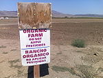
Soledad's farmland is considered "Prime Farmland", meaning the soils around and near the city have some of the best physical and chemical characteristics for farming. Due to this fact great efforts in conserving farmland are a very high priority for the city. Prime farmland is the backbone of the Soledad economy. Future planning will consider the effect of urban sprawl amongst the farmlands. Class I, II, and III soils are the most valuable to farming. The climate also allows for year round crops.
Although Soledad has great soil for salad green crops, it also has a large presence of vineyards and wineries in the valley and foothills. Some famous wineries include Chalone Vineyards, Paraiso Springs Vineyards, Zabala Vineyards, Hahn Estates, Richard Boyer Wines, Smith and Hook Winery, and Ventana Vineyards. It was once the home of the Paul Masson
Winery which is now closed.
Dole Food Company
maintains a plant in Soledad. Opened in 1994, it is touted as being the "world's largest pre-cut salad plant."
As of 2007, Soledad features a weekly certified Farmers' Market
on Soledad St.
.
As of mid-2006, the plant was again closed.
Controversy surrounding the plant.
Several violations at the plant have been issued by the California Integrated Water Quality System Project. The plant was issued violations from 2002 to 2006 for various reporting and pollution allegations.
and is accessible via northbound and southbound exit ramps on Front Street, at the north and south ends of town.
Soledad is serviced by the Monterey-Salinas Transit line 23 (Salinas - King City). As of September 5, 2009, the bus stops in Soledad are located at the correctional facility, Front & San Vicente and Monterey & East. http://www.mst.org/
Television service for the community comes from the Monterey-Salinas-Santa Cruz designated market area (DMA). Radio stations Monterey-Salinas-Santa Cruz area of dominant influence (ADI) or continuous measurement market (CMM). Local newspapers include the Monterey County Herald, Salinas Californian and Soledad Bee.
Soledad is also the setting of the story in John Steinbeck
's novel, Of Mice and Men
) built in 1946. It was also one of the first 12 prisons of the California Department of Corrections and Rehabilitation
. The other two are the Gabilan Fire camp and the Salinas Valley State Correctional Facility, which opened in 1996.
Monterey County, California
Monterey County is a county located on the Pacific coast of the U.S. state of California, its northwestern section forming the southern half of Monterey Bay. The northern half of the bay is in Santa Cruz County. As of 2010, the population was 415,057. The county seat and largest city is Salinas...
, United States. Soledad is located 25 miles (40 km) southeast of Salinas
Salinas, California
Salinas is the county seat and the largest municipality of Monterey County, California. Salinas is located east-southeast of the mouth of the Salinas River, at an elevation of about 52 feet above sea level. The population was 150,441 at the 2010 census...
, at an elevation of 190 feet (58 m). The population was 25,738 at the 2010 census.
The town is located near the original Spanish mission, Mission Nuestra Señora de la Soledad
Mission Nuestra Señora de la Soledad
Mission Nuestra Señora de la Soledad is in the Salinas Valley near Soledad, in central Monterey County, California. The mission was founded on October 9, 1791 for the increasing settlement of upper Las Californias Province of the Viceroyalty of New Spain, and for the Indian Reductions to convert...
, founded October 9, 1791 by Fermín Francisco de Lasuén
Fermín Lasuén
Father Padre Fermín de Francisco Lasuén de Arasqueta was a Spanish missionary to Alta California, the second presidente and founder of the California Franciscan Mission Chain....
, the 13th of 21 missions in the California mission
Spanish missions in California
The Spanish missions in California comprise a series of religious and military outposts established by Spanish Catholics of the Franciscan Order between 1769 and 1823 to spread the Christian faith among the local Native Americans. The missions represented the first major effort by Europeans to...
chain.
Soledad is located in one of the primary wine grape growing regions of California with over twenty vineyards and wineries within a thirty mile radius, several of which have tasting rooms and offer a wide selection of wines for sale. Some of the Vineyards and Wineries located nearby are Chalone, Scheid, Paraiso Vineyards, Pisoni Vineyards, Hahn Estates Smith & Hook, San Saba, J.Lohr, Kendall-Jackson, Ventana, Hess Select, Estancia, The Michaud Vineyard, and Graff Family Vineyards.
History
The original community of Soledad was founded as a Spanish missionSpanish missions in California
The Spanish missions in California comprise a series of religious and military outposts established by Spanish Catholics of the Franciscan Order between 1769 and 1823 to spread the Christian faith among the local Native Americans. The missions represented the first major effort by Europeans to...
October 9, 1791 by Fermín Lasuén
Fermín Lasuén
Father Padre Fermín de Francisco Lasuén de Arasqueta was a Spanish missionary to Alta California, the second presidente and founder of the California Franciscan Mission Chain....
, and founded under the rule of the Viceroyalty of New Spain (Virreinato de Nueva España) 1535 to 1821.
The Soledad post office opened in 1869. The current community of Soledad in 1874 had a few buildings and shops. The two main streets were named Front and Main. In 1886, land was subdivided into lots and sold by its owners, the Munras family. In the late 1880s the Southern Pacific Railroad laid rails and began serving the area.
In 1898 Fort Romie was founded a few miles north of the mission and west of the city. San Vicente School was built in 1913 forming the Soledad School District. The City, a general law city, incorporated in March 1921 with a City Council/City Manager form of government. The city's name comes from the mission Mission Nuestra Señora de la Soledad
Mission Nuestra Señora de la Soledad
Mission Nuestra Señora de la Soledad is in the Salinas Valley near Soledad, in central Monterey County, California. The mission was founded on October 9, 1791 for the increasing settlement of upper Las Californias Province of the Viceroyalty of New Spain, and for the Indian Reductions to convert...
.
Soledad is used as a backdrop in John Steinbeck
John Steinbeck
John Ernst Steinbeck, Jr. was an American writer. He is widely known for the Pulitzer Prize-winning novel The Grapes of Wrath and East of Eden and the novella Of Mice and Men...
's novella Of Mice and Men
Of Mice and Men
Of Mice and Men is a novella written by Nobel Prize-winning author John Steinbeck. Published in 1937, it tells the tragic story of George Milton and Lennie Small, two displaced migrant ranch workers during the Great Depression in California, USA....
1937, an emotional novel about two close financially failing friends of opposite personalities who must farm others land to make what meager living they can, always dreaming for their own personal property. One of the most important themes of the novel is loneliness, which is likely one of the reason why Soledad was chosen as the setting, as Soledad is Spanish for solitude.
Soledad has been rocked by the great 1906 San Francisco earthquake
1906 San Francisco earthquake
The San Francisco earthquake of 1906 was a major earthquake that struck San Francisco, California, and the coast of Northern California at 5:12 a.m. on Wednesday, April 18, 1906. The most widely accepted estimate for the magnitude of the earthquake is a moment magnitude of 7.9; however, other...
and the Loma Prieta earthquake
Loma Prieta earthquake
The Loma Prieta earthquake, also known as the Quake of '89 and the World Series Earthquake, was a major earthquake that struck the San Francisco Bay Area of California on October 17, 1989, at 5:04 p.m. local time...
in 1989.
The Soledad Prison
Correctional Training Facility
Correctional Training Facility is a state prison located on U.S. Highway 101, north of Soledad, California. Randy Grounds is the current Warden of the prison.-Facilities:...
was three miles (5 km) north of the city until annexed in 1992. It was built in 1946 and currently has an operating budget of $245 million.
The infamous "Nortenos
Norteños
The Norteños , also Norte, are affiliated with Nuestra Familia , are a coalition of traditionally Latino gangs in Northern California A member of these gangs is a Norteño or Norteña based on Spanish usage...
" gang was founded in 1968 along with Nuestra Familia
Nuestra Familia
Nuestra Familia is a criminal organization of Mexican American prison gangs with origins in Northern California. While members of the Norteños gang are considered to be affiliated with Nuestra Familia, being a member of Nuestra Familia itself does not signify association as a Norteño...
crime syndicate in the Soledad Prison. Most of the members became FBI informants to bring the nuestra familia crime syndicate apart. Due to this the "Norteno" association has been dealt a severe blow to their structure, resulting in the weakening of their units.
In May 1996 the Salinas Valley State Prison
Salinas Valley State Prison
Salinas Valley State Prison is a Californian state prison located 5 miles north of Soledad, in Monterey County, California.The prison consists of four yards: A, B, C, and D. Of the four, C is the most violent...
was opened at a cost of $236 million, with an annual operating budget of $60 million. Currently as of 2007 the annual operating budget has risen to $177 million yearly.
On April 28, 2009, a tour bus transporting 34 French tourists flipped over at an overpass on Soledad's north entrance. At least five passengers were killed, one of whom fell over the bridge onto the railroad tracks beneath it.
Geography
Soledad is located at 36°25′29"N 121°19′35"W.According to the United States Census Bureau
United States Census Bureau
The United States Census Bureau is the government agency that is responsible for the United States Census. It also gathers other national demographic and economic data...
, the city has a total area of 4.6 square miles (11.9 km²), 96.68% of it land and 3.32% of it water.
Soledad is about six miles (10 km) southeast of Pinnacles National Monument
Pinnacles National Monument
Pinnacles National Monument is a protected mountainous area located east of central California's Salinas Valley, just miles from the town of Soledad...
, nestled among the nearby Gabilan Mountains.
Demographics
2010
The 2010 United States Census reported that Soledad had a population of 25,738. The population densityPopulation density
Population density is a measurement of population per unit area or unit volume. It is frequently applied to living organisms, and particularly to humans...
was 5,637.5 people per square mile (2,176.7/km²). The racial makeup of Soledad was 12,625 (49.1%) White, 2,945 (11.4%) African American, 367 (1.4%) Native American, 757 (2.9%) Asian, 103 (0.4%) Pacific Islander, 8,189 (31.8%) from other races
Race (United States Census)
Race and ethnicity in the United States Census, as defined by the Federal Office of Management and Budget and the United States Census Bureau, are self-identification data items in which residents choose the race or races with which they most closely identify, and indicate whether or not they are...
, and 752 (2.9%) from two or more races. Hispanic or Latino of any race were 18,308 persons (71.1%).
The Census reported that 15,635 people (60.7% of the population) lived in households, 0 (0%) lived in non-institutionalized group quarters, and 10,103 (39.3%) were institutionalized.
There were 3,664 households, out of which 2,471 (67.4%) had children under the age of 18 living in them, 2,387 (65.1%) were opposite-sex married couples
Marriage
Marriage is a social union or legal contract between people that creates kinship. It is an institution in which interpersonal relationships, usually intimate and sexual, are acknowledged in a variety of ways, depending on the culture or subculture in which it is found...
living together, 586 (16.0%) had a female householder with no husband present, 291 (7.9%) had a male householder with no wife present. There were 224 (6.1%) unmarried opposite-sex partnerships
POSSLQ
POSSLQ is an abbreviation for "Persons of Opposite Sex Sharing Living Quarters," a term coined in the late 1970s by the United States Census Bureau as part of an effort to more accurately gauge the prevalence of cohabitation in American households....
, and 30 (0.8%) same-sex married couples or partnerships. 301 households (8.2%) were made up of individuals and 123 (3.4%) had someone living alone who was 65 years of age or older. The average household size was 4.27. There were 3,264 families
Family (U.S. Census)
A family or family household is defined by the United States Census Bureau for statistical purposes as "a householder and one or more other people related to the householder by birth, marriage, or adoption. They do not include same-sex married couples even if the marriage was performed in a state...
(89.1% of all households); the average family size was 4.41.
The population was spread out with 5,674 people (22.0%) under the age of 18, 2,455 people (9.5%) aged 18 to 24, 10,126 people (39.3%) aged 25 to 44, 6,296 people (24.5%) aged 45 to 64, and 1,187 people (4.6%) who were 65 years of age or older. The median age was 34.9 years. For every 100 females there were 235.5 males. For every 100 females age 18 and over, there were 301.8 males.
There were 3,876 housing units at an average density of 849.0 per square mile (327.8/km²), of which 2,092 (57.1%) were owner-occupied, and 1,572 (42.9%) were occupied by renters. The homeowner vacancy rate was 2.4%; the rental vacancy rate was 4.1%. 8,642 people (33.6% of the population) lived in owner-occupied housing units and 6,993 people (27.2%) lived in rental housing units.
2006
As of the intercensal estimateIntercensal estimate
Intercensal estimate in the field of demographics is an estimate of population between official census dates. Some nations produce regular intercensal estimates while others do not...
of 2006, there were 28,075 people, 2,472 households, and 2,242 families residing in the city. The population density was 2,680.0 inhabitants per square mile (1,035.4/km²). There were 2,534 housing units at an average density of 232.9/km² (603.0/poo of this mission is makeup of the city was 31.90% White, 1.15% African American, 1.73% Native American, 2.35% Asian, 0.08% Pacific Islander, 58.56% from other races
Race (United States Census)
Race and ethnicity in the United States Census, as defined by the Federal Office of Management and Budget and the United States Census Bureau, are self-identification data items in which residents choose the race or races with which they most closely identify, and indicate whether or not they are...
, and 4.23% from two or more races. Hispanic or Latino of any race were 86.82% of the population.
There were 2,472 households out of which 60.2% had children under the age of 18 living with them, 69.9% were married couples living together, 13.8% had a female householder with no husband present, and 9.3% were non-families. 7.2% of all households were made up of individuals and 3.7% had someone living alone who was 65 years of age or older. The average household size was 4.54 and the average family size was 4.58.
In the city the population was spread out with 36.7% under the age of 18, 12.9% from 18 to 24, 31.4% from 25 to 44, 13.1% from 45 to 64, and 5.9% who were 65 years of age or older. The median age was 25 years. For every 100 females there were 108.0 males. For every 100 females age 18 and over, there were 106.6 males.
The median income for a household in the city was $42,602, and the median income for a family was $41,188. Males had a median income of $31,566 versus $23,964 for females. The per capita income
Per capita income
Per capita income or income per person is a measure of mean income within an economic aggregate, such as a country or city. It is calculated by taking a measure of all sources of income in the aggregate and dividing it by the total population...
for the city was $11,442. About 16.3% of families and 18.4% of the population were below the poverty line, including 25.1% of those under age 18 and 9.2% of those age 65 or over.
Economy
Although Soledad is known for its Agriculture it was once the home of timber production. Soledad was home to the Sequoia Forest Industries sawmill. It was closed in 1991 and approximately 91 jobs were lost due to the closure of the mill. The warehouse is still in the city as a reminder of past industrial opportunities the small town had to offer.Agriculture
Natural resource
Natural resources occur naturally within environments that exist relatively undisturbed by mankind, in a natural form. A natural resource is often characterized by amounts of biodiversity and geodiversity existent in various ecosystems....
.
Soledad's farmland is considered "Prime Farmland", meaning the soils around and near the city have some of the best physical and chemical characteristics for farming. Due to this fact great efforts in conserving farmland are a very high priority for the city. Prime farmland is the backbone of the Soledad economy. Future planning will consider the effect of urban sprawl amongst the farmlands. Class I, II, and III soils are the most valuable to farming. The climate also allows for year round crops.
Although Soledad has great soil for salad green crops, it also has a large presence of vineyards and wineries in the valley and foothills. Some famous wineries include Chalone Vineyards, Paraiso Springs Vineyards, Zabala Vineyards, Hahn Estates, Richard Boyer Wines, Smith and Hook Winery, and Ventana Vineyards. It was once the home of the Paul Masson
Paul Masson
Paul Masson was an early pioneer of California viticulture and successful popularizer of Californian sparkling wine.-Biography:...
Winery which is now closed.
Dole Food Company
Dole Food Company
Dole Food Company, Inc. is an American-based agricultural multinational corporation headquartered in Westlake Village, California. The company is the largest producer of fruits and vegetables in the world, operating with 74,300 full-time and seasonal employees who are responsible for over 300...
maintains a plant in Soledad. Opened in 1994, it is touted as being the "world's largest pre-cut salad plant."
As of 2007, Soledad features a weekly certified Farmers' Market
Farmers' market
A farmers' market consists of individual vendors—mostly farmers—who set up booths, tables or stands, outdoors or indoors, to sell produce, meat products, fruits and sometimes prepared foods and beverages...
on Soledad St.
Energy
Soledad is home to the Soledad Energy Partnership, operators of a wood-waste burning electric power plant. This 13.5 megawatt facility was restarted in July 2001 after a six year shut-down due to termination of a PG&E purchase agreement. The plant was recommissioned during the California electricity crisisCalifornia electricity crisis
The California electricity crisis, also known as the Western U.S. Energy Crisis of 2000 and 2001 was a situation in which California had a shortage of electricity caused by market manipulations and illegal shutdowns of pipelines by Texas energy consortiums...
.
As of mid-2006, the plant was again closed.
Controversy surrounding the plant.
Several violations at the plant have been issued by the California Integrated Water Quality System Project. The plant was issued violations from 2002 to 2006 for various reporting and pollution allegations.
Transportation
Soledad is located on U.S. Route 101U.S. Route 101
U.S. Route 101, or U.S. Highway 101, is an important north–south U.S. highway that runs through the states of California, Oregon, and Washington, on the West Coast of the United States...
and is accessible via northbound and southbound exit ramps on Front Street, at the north and south ends of town.
Soledad is serviced by the Monterey-Salinas Transit line 23 (Salinas - King City). As of September 5, 2009, the bus stops in Soledad are located at the correctional facility, Front & San Vicente and Monterey & East. http://www.mst.org/
Clubs, groups, and organizations
- Soledad Rotary Club
- Boy Scouts of AmericaBoy Scouts of AmericaThe Boy Scouts of America is one of the largest youth organizations in the United States, with over 4.5 million youth members in its age-related divisions...
- Soledad FFA Chapter
- Soledad Lions Club
- 4-H4-H4-H in the United States is a youth organization administered by the National Institute of Food and Agriculture of the United States Department of Agriculture , with the mission of "engaging youth to reach their fullest potential while advancing the field of youth development." The name represents...
- The Freemasons
- Girl Scouts of the USAGirl Scouts of the USAThe Girl Scouts of the United States of America is a youth organization for girls in the United States and American girls living abroad. It describes itself as "the world's preeminent organization dedicated solely to girls". It was founded by Juliette Gordon Low in 1912 and was organized after Low...
Education
Soledad Unified School District serves approximately 3,900 students in grades K-12. There are 5 elementary schools, 1 middle school, 1 comprehensive high school and 1 community education center which houses a variety of alternative programs. These programs include adult education, regional occupational program (ROP), independent study, and a continuation high school.- San Vicente Elementary Founded 1913
- Frank Ledesma Elementary
- Jack Franscioni Elementary,
- Gabilan Elementary Founded 1980
- Rose Ferrero Elementary, 2001
- Main St. Middle school, Home of the Trojans Founded 1908
- Soledad High School, Home of the Aztecs Founded 1999
- Chalone Alternative School
- Pinnacles Continuation High School
- Soledad Adult School
- Mission Trails Regional Occupation Program
Media
- See also: Media in Monterey CountyMedia in Monterey CountyMedia in Monterey County is a designated market area or media market that includes print media and broadcast media in Monterey County, California....
Television service for the community comes from the Monterey-Salinas-Santa Cruz designated market area (DMA). Radio stations Monterey-Salinas-Santa Cruz area of dominant influence (ADI) or continuous measurement market (CMM). Local newspapers include the Monterey County Herald, Salinas Californian and Soledad Bee.
Soledad is also the setting of the story in John Steinbeck
John Steinbeck
John Ernst Steinbeck, Jr. was an American writer. He is widely known for the Pulitzer Prize-winning novel The Grapes of Wrath and East of Eden and the novella Of Mice and Men...
's novel, Of Mice and Men
Of Mice and Men
Of Mice and Men is a novella written by Nobel Prize-winning author John Steinbeck. Published in 1937, it tells the tragic story of George Milton and Lennie Small, two displaced migrant ranch workers during the Great Depression in California, USA....
Prisons
The city has three separate correctional facilities in the northernmost part of the city. The first and oldest prison is Soledad CTF (Correctional Training FacilityCorrectional Training Facility
Correctional Training Facility is a state prison located on U.S. Highway 101, north of Soledad, California. Randy Grounds is the current Warden of the prison.-Facilities:...
) built in 1946. It was also one of the first 12 prisons of the California Department of Corrections and Rehabilitation
California Department of Corrections and Rehabilitation
The California Department of Corrections and Rehabilitation is responsible for the operation of the California state prison and parole systems. CDC&R is the second largest law enforcement or police agency in the United States behind the New York City Police Department which employs approximately...
. The other two are the Gabilan Fire camp and the Salinas Valley State Correctional Facility, which opened in 1996.
Recreation
- See also: Monterey county attractionsMonterey county attractionsMonterey County is a county on the Pacific coast of the U.S. state of California, its northwestern section forming the southern half of Monterey Bay. As of 2000, the population was 401,762. The coastline includes Big Sur, State Route 1, and the 17 Mile Drive on the Monterey Peninsula. The city of...
- Pinnacles National MonumentPinnacles National MonumentPinnacles National Monument is a protected mountainous area located east of central California's Salinas Valley, just miles from the town of Soledad...
. Hiking and rock climbing - The Pinnacles Wine Festival
- Arroyo Seco (Monterey)Arroyo Seco (Monterey)The Arroyo Seco AVA is an American Viticultural Area in Monterey County, California, southeast of Monterey Bay. The appellation encompasses in the valley adjacent to the Arroyo Seco Creek. Because of its proximity to the Pacific Ocean, the area has a cool climate, and is best suited for those...
County - The Salinas RiverSalinas River (California)The Salinas River is the largest river of the central coast of California, running and draining 4,160 square miles. It flows north-northwest and drains the Salinas Valley that slices through the Coast Range south from Monterey Bay...
- Soledad YMCAYMCAThe Young Men's Christian Association is a worldwide organization of more than 45 million members from 125 national federations affiliated through the World Alliance of YMCAs...
- Soledad Mission. Mission Nuestra Señora de la SoledadMission Nuestra Señora de la SoledadMission Nuestra Señora de la Soledad is in the Salinas Valley near Soledad, in central Monterey County, California. The mission was founded on October 9, 1791 for the increasing settlement of upper Las Californias Province of the Viceroyalty of New Spain, and for the Indian Reductions to convert...
- Vosti Park
- Soledad Swimming Pool. Home of the Soledad Sharks swimming team.
- Little League Field
- Front Street Park
- Peverini Park
See also
- Coastal CaliforniaCoastal CaliforniaCoastal California refers to the coastal regions of the US state of California. The term is not primarily geographical as it also describes an area distinguished by sociological, economical and political attributes...
- List of school districts in Monterey County, California
- Monterey county attractionsMonterey county attractionsMonterey County is a county on the Pacific coast of the U.S. state of California, its northwestern section forming the southern half of Monterey Bay. As of 2000, the population was 401,762. The coastline includes Big Sur, State Route 1, and the 17 Mile Drive on the Monterey Peninsula. The city of...