

San Luis Obispo County, California
Encyclopedia
San Luis Obispo County is a county
located along the Pacific Ocean
in the Central Coast
of the U.S. state
of California
, between Los Angeles
and the San Francisco Bay Area
. As of the 2010 census its population was 269,637, up from 246,681 at the 2000 census. The county seat
is San Luis Obispo
, with about 46,000 residents.
The county's distance from the large metro areas of San Francisco and Los Angeles has helped it to retain its rural character and reminders of old California abound. Commonly referred to as "the Central Coast," the area is more rural and agricultural than many other coastal regions in California. Father Junipero Serra
founded the Mission San Luis Obispo de Tolosa
in 1772 and the Mission is today an active part of downtown San Luis Obispo (popularly referred to as SLO or SLO-town). The small size of the county's communities, scattered along the beaches, coastal hills, and mountains of the Santa Lucia range, provides a wide variety of coastal and inland hill ecologies to support many kinds of fishing, agriculture, and tourist activities.
The mainstays of the economy are California Polytechnic State University
with its almost 20,000 students, tourism, and agriculture. San Luis Obispo County is the third largest producer of wine in California, surpassed only by Sonoma and Napa Counties. Wine grapes are by far the largest agricultural crop in the county, and the wine production they support creates a direct economic impact and a growing wine country vacation industry.
The town of San Simeon
is located at the foot of the hill where newspaper
publisher William Randolph Hearst
built the famed Hearst Castle
. Other coastal towns include Cambria
, Morro Bay and Cayucos to the north of San Luis Obispo city, and Avila Beach
and the Five Cities to the south: Arroyo Grande, Grover Beach, Oceano
, Pismo Beach and Shell Beach. Nipomo, just south of the Five Cities, borders northern Santa Barbara County. Inland, the cities of Paso Robles, Templeton
, and Atascadero lie along the Salinas River
, near the Paso Robles wine region. Just south of Cambria lies Harmony
, one of the smallest towns in California with a population of 18.
thousands of years before the present age. Important settlements existed, for example, in many coastal areas such as Morro Bay and Los Osos.
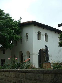 Mission San Luis Obispo de Tolosa
was founded on September 1, 1772 in the area that is now the city of San Luis Obispo
.
San Luis Obispo County was one of the original counties of California, created in 1850 at the time of statehood.
The Salinas River Valley, a region that figures strongly in several Steinbeck novels, stretches north from San Luis Obispo County. The remote California Valley near Soda Lake is the region most untouched by modernity. Travels through this area and the hills east of highway 101 during wildflower season are very beautiful and can be incorporated with wine tasting at local vineyards.
trains and Greyhound Lines
buses.
The San Luis Obispo Regional Transit Authority
provides countywide service along US 101 as well as service to Morro Bay, Los Osos, Cambria and San Simeon.
The cities of San Luis Obispo, Atascadero and Paso Robles operate their own local bus services;
all of these connect with SLORTA routes.
Intercity service is provided by Amtrak
trains, Greyhound
and Orange Belt Stages
buses.
San Luis Obispo County, as a whole, leans toward the Republican
Party in presidential
and congressional
elections. In 2008, however, Barack Obama
won the county with 51.2 percent of the vote. Prior to Obama's victory, the last Democrat
to win a majority in the county was Lyndon Johnson
in 1964
.
Coastal San Luis Obispo is part of California's 23rd congressional district
, which is held by Democrat Lois Capps, while the inland is part of the 22nd district
, which is held by Republican Kevin McCarthy. In the state legislature
, San Luis Obispo is part of the 33rd Assembly district, which is held by Republican Katcho Achadjian
, and the 15th Senate district, which is held by Republican Sam Blakeslee
.
In April 2008, the California Secretary of State reported that there were 147,326 registered voters in San Luis Obispo County. Of those voters, 61,226 (41.6%) were registered Republicans, 52,586 (35.7%) were registered Democratic, 8,030 (5.4%) are registered with other political parties, and 25,484 (17.3%) declined to state a political preference. The cities of Grover Beach, Morro Bay, and San Luis Obispo had pluralities or majorities of registered Democratic voters, whereas the rest of the county's towns, cities, and the unincorporated areas have a plurality or majority of registered Republican voters.
What the government classifies as “service jobs” account for 38% of the county’s jobs, the true service sector is larger. Government jobs accounts for 20.7% of the County, which is also recognized as a service sector. The presence of Finance, Insurance, and Real Estate sector can also be classified as a service sector. Services and Retail combined accounts for 75% of county jobs. Manufacturing jobs now represent less than 6% of the county jobs.
For more information on San Luis Obispo County's Economic Profile, visit ECONOMIC VITALITY CORPORATION (http://www.sloevc.org).
, and 10,113 (3.8%) from two or more races. Hispanic or Latino of any race were 55,973 persons (20.8%); 17.7% of San Luis Obispo County is Mexican, 0.3% Puerto Rican, and 0.2% Salvadoran.
of 2000, there were 246,681 residents, 92,739 households, and 58,611 families in the county. The population density
was 75 people per square mile (29/km²). There were 102,275 housing units at an average density of 31 per square mile (12/km²). The racial makeup of the county was 84.60% White
, 2.03% Black
or African American
, 0.95% Native American
, 2.66% Asian
, 0.12% Pacific Islander
, 6.21% from other races
, and 3.44% from two or more races. 16.29% of the population were Hispanic
or Latino
of any race. 13.9% were of German, 11.4% English
, 9.7% Irish
, 6.1% American
and 5.7% Italian
ancestry according to Census 2000. 85.7% spoke English
and 10.7% Spanish
as their first language.
There were 92,739 households out of which 28.2% had children under the age of 18 living with them, 50.40% were married couples
living together, 9.1% had a female householder with no husband present, and 36.8% were non-families. 26.0% of all households were made up of individuals and 10.3% had someone living alone who was 65 years of age or older. The average household size was 2.49 and the average family size was 3.01.
In the county the population was spread out with 21.7% under the age of 18, 13.60% from 18 to 24, 27.0% from 25 to 44, 23.3% from 45 to 64, and 14.5% who were 65 years of age or older. The median age was 37 years. For every 100 females there were 105.6 males. For every 100 females age 18 and over, there were 105.2 males.
The median income for a household in the county was $42,428, and the median income for a family was $52,447. Males had a median income of $40,726 versus $27,450 for females. The per capita income
for the county was $21,864. About 6.8% of families and 12.8% of the population were below the poverty line, including 11.4% of those under age 18 and 5.9% of those age 65 or over.
County (United States)
In the United States, a county is a geographic subdivision of a state , usually assigned some governmental authority. The term "county" is used in 48 of the 50 states; Louisiana is divided into parishes and Alaska into boroughs. Parishes and boroughs are called "county-equivalents" by the U.S...
located along the Pacific Ocean
Pacific Ocean
The Pacific Ocean is the largest of the Earth's oceanic divisions. It extends from the Arctic in the north to the Southern Ocean in the south, bounded by Asia and Australia in the west, and the Americas in the east.At 165.2 million square kilometres in area, this largest division of the World...
in the Central Coast
Central Coast of California
The Central Coast is an area of California, United States, roughly spanning the area between the Monterey Bay and Point Conception. It extends through Santa Cruz County, San Benito County, Monterey County, San Luis Obispo County, and Santa Barbara County...
of the U.S. state
U.S. state
A U.S. state is any one of the 50 federated states of the United States of America that share sovereignty with the federal government. Because of this shared sovereignty, an American is a citizen both of the federal entity and of his or her state of domicile. Four states use the official title of...
of California
California
California is a state located on the West Coast of the United States. It is by far the most populous U.S. state, and the third-largest by land area...
, between Los Angeles
Los Angeles, California
Los Angeles , with a population at the 2010 United States Census of 3,792,621, is the most populous city in California, USA and the second most populous in the United States, after New York City. It has an area of , and is located in Southern California...
and the San Francisco Bay Area
San Francisco Bay Area
The San Francisco Bay Area, commonly known as the Bay Area, is a populated region that surrounds the San Francisco and San Pablo estuaries in Northern California. The region encompasses metropolitan areas of San Francisco, Oakland, and San Jose, along with smaller urban and rural areas...
. As of the 2010 census its population was 269,637, up from 246,681 at the 2000 census. The county seat
County seat
A county seat is an administrative center, or seat of government, for a county or civil parish. The term is primarily used in the United States....
is San Luis Obispo
San Luis Obispo, California
San Luis Obispo is a city in California, located roughly midway between San Francisco and Los Angeles on the Central Coast. Founded in 1772 by Spanish Fr. Junipero Serra, San Luis Obispo is one of California’s oldest communities...
, with about 46,000 residents.
The county's distance from the large metro areas of San Francisco and Los Angeles has helped it to retain its rural character and reminders of old California abound. Commonly referred to as "the Central Coast," the area is more rural and agricultural than many other coastal regions in California. Father Junipero Serra
Junípero Serra
Blessed Junípero Serra, O.F.M., , known as Fra Juníper Serra in Catalan, his mother tongue was a Majorcan Franciscan friar who founded the mission chain in Alta California of the Las Californias Province in New Spain—present day California, United States. Fr...
founded the Mission San Luis Obispo de Tolosa
Mission San Luis Obispo de Tolosa
Mission San Luis Obispo de Tolosa was founded 1772 on the Central Coast of California on a site located halfway between Santa Barbara and Monterey. It was named after Saint Louis of Anjou, the bishop of Toulouse. The Mission church of San Luis Obispo is unusual in its design in that its...
in 1772 and the Mission is today an active part of downtown San Luis Obispo (popularly referred to as SLO or SLO-town). The small size of the county's communities, scattered along the beaches, coastal hills, and mountains of the Santa Lucia range, provides a wide variety of coastal and inland hill ecologies to support many kinds of fishing, agriculture, and tourist activities.
The mainstays of the economy are California Polytechnic State University
California Polytechnic State University
California Polytechnic State University, or Cal Poly, is a public university located in San Luis Obispo, California, United States. The university is one of two polytechnic campuses in the 23-member California State University system....
with its almost 20,000 students, tourism, and agriculture. San Luis Obispo County is the third largest producer of wine in California, surpassed only by Sonoma and Napa Counties. Wine grapes are by far the largest agricultural crop in the county, and the wine production they support creates a direct economic impact and a growing wine country vacation industry.
The town of San Simeon
San Simeon, California
San Simeon is a census-designated place on the Pacific coast of San Luis Obispo County, California. Its position along State Route 1 is approximately halfway between Los Angeles and San Francisco, each of those cities being roughly 230 mi away...
is located at the foot of the hill where newspaper
Newspaper
A newspaper is a scheduled publication containing news of current events, informative articles, diverse features and advertising. It usually is printed on relatively inexpensive, low-grade paper such as newsprint. By 2007, there were 6580 daily newspapers in the world selling 395 million copies a...
publisher William Randolph Hearst
William Randolph Hearst
William Randolph Hearst was an American business magnate and leading newspaper publisher. Hearst entered the publishing business in 1887, after taking control of The San Francisco Examiner from his father...
built the famed Hearst Castle
Hearst Castle
Hearst Castle is a National Historic Landmark mansion located on the Central Coast of California, United States. It was designed by architect Julia Morgan between 1919 and 1947 for newspaper magnate William Randolph Hearst, who died in 1951. In 1957, the Hearst Corporation donated the property to...
. Other coastal towns include Cambria
Cambria, California
Cambria is a seaside village located midway between San Francisco and Los Angeles on the California State Route 1 . The name Cambria was settled upon in 1869 .It is a census-designated place in San Luis Obispo County, California, United States...
, Morro Bay and Cayucos to the north of San Luis Obispo city, and Avila Beach
Avila Beach
Avila Beach , pronounced AH-vuh-luh or spanish pronunciation as AH-vee-lah, is a census-designated place in San Luis Obispo County, California, USA and located about 160 miles northwest of Los Angeles, and about 200 miles south of San Francisco. The ZIP Code is 93424. The community is inside area...
and the Five Cities to the south: Arroyo Grande, Grover Beach, Oceano
Océano
Océano is the third studio album by Argentine singer Pablo Ruiz. It was released in 1989.- Track listing :# Océano# La Chica De La Tele# Soñando En La Lluvia# Mi Corazón Se Fue# Este Mundo# Quiero Tu Amor# Hawái# Ámame Pronto# Hey Valentina...
, Pismo Beach and Shell Beach. Nipomo, just south of the Five Cities, borders northern Santa Barbara County. Inland, the cities of Paso Robles, Templeton
Templeton, California
Templeton is a census-designated place in San Luis Obispo County, California. The population was 7,674 at the 2010 census, up from 4,687 at the 2000 census.-Geography:...
, and Atascadero lie along the Salinas River
Salinas River (California)
The Salinas River is the largest river of the central coast of California, running and draining 4,160 square miles. It flows north-northwest and drains the Salinas Valley that slices through the Coast Range south from Monterey Bay...
, near the Paso Robles wine region. Just south of Cambria lies Harmony
Harmony, California
Harmony is an unincorporated town located in San Luis Obispo County, California. It lies north of Cayucos and south of Cambria on SR 1, near the junction with SR 46. The ZIP Code is 93435...
, one of the smallest towns in California with a population of 18.
History
The prehistory of San Luis Obispo County is strongly influenced by the Chumash people who had significant settlement here at least as early as the Millingstone HorizonMillingstone Horizon
Millingstone Horizon is an archaeological period of Native American dominance denoting a period in California, USA involving extensive use of manos and other grinding technology. The interval is a subset of the Archaic Period; specifically Millingstone is usually applied to the period 6500 to...
thousands of years before the present age. Important settlements existed, for example, in many coastal areas such as Morro Bay and Los Osos.
Mission San Luis Obispo de Tolosa
Mission San Luis Obispo de Tolosa was founded 1772 on the Central Coast of California on a site located halfway between Santa Barbara and Monterey. It was named after Saint Louis of Anjou, the bishop of Toulouse. The Mission church of San Luis Obispo is unusual in its design in that its...
was founded on September 1, 1772 in the area that is now the city of San Luis Obispo
San Luis Obispo, California
San Luis Obispo is a city in California, located roughly midway between San Francisco and Los Angeles on the Central Coast. Founded in 1772 by Spanish Fr. Junipero Serra, San Luis Obispo is one of California’s oldest communities...
.
San Luis Obispo County was one of the original counties of California, created in 1850 at the time of statehood.
The Salinas River Valley, a region that figures strongly in several Steinbeck novels, stretches north from San Luis Obispo County. The remote California Valley near Soda Lake is the region most untouched by modernity. Travels through this area and the hills east of highway 101 during wildflower season are very beautiful and can be incorporated with wine tasting at local vineyards.
Geography
According to the 2000 census, the county has a total area of 3615.54 square miles (9,364.2 km²), of which 3304.32 square miles (8,558.1 km²) (or 91.39%) is land and 311.22 square miles (806.1 km²) (or 8.61%) is water.Incorporated Cities
- Arroyo GrandeArroyo Grande, CaliforniaArroyo Grande is a city in San Luis Obispo County, California, United States. The population was 17,252 at the 2010 census.-Geography:Arroyo Grande is a small coastal town with historic, suburban, and rural elements located at...
- AtascaderoAtascadero, CaliforniaAtascadero is a city in San Luis Obispo County, California, about equidistant from San Francisco and Los Angeles on U-S Highway 101. Atascadero is farther inland than most other San Luis Obispo County cities, and as a result, usually experiences warmer, drier summers and cooler winters than...
- Grover BeachGrover Beach, CaliforniaGrover Beach is a city in San Luis Obispo County, California, United States. The population was 13,156 at the 2010 census, up from 13,067 at the 2000 census. This city was originally called, "Grover City". The name was changed by popular vote in 1992 to emphasize the seaside...
- Morro BayMorro Bay, CaliforniaMorro Bay is a waterfront city in San Luis Obispo County, California, United States. As of the 2010 census, the city population was 10,234, down from 10,350 at the 2000 census.- History :...
- Paso RoblesPaso Robles, CaliforniaPaso Robles is a city in San Luis Obispo County, California, United States. Paso Robles is the fastest growing city in San Luis Obispo County: Its population at the 2000 census was 24,297; in 2010 it recorded some 29,793 residentsLocated on the Salinas River north of San Luis Obispo, California,...
- Pismo BeachPismo Beach, CaliforniaPismo Beach is a city in San Luis Obispo County, California, United States. The population was 7,655 at the 2010 census, down from 8,551 at the 2000 census...
- San Luis ObispoSan Luis Obispo, CaliforniaSan Luis Obispo is a city in California, located roughly midway between San Francisco and Los Angeles on the Central Coast. Founded in 1772 by Spanish Fr. Junipero Serra, San Luis Obispo is one of California’s oldest communities...
Unincorporated Census-designated places
- Avilla Beach
- BlacklakeBlacklake, CaliforniaBlacklake is a census-designated place in San Luis Obispo County, California. Blacklake sits at an elevation of . The 2010 United States census reported Blacklake's population was 930.-Geography:...
- CallenderCallender, CaliforniaCallender is a census-designated place in San Luis Obispo County, California, United States. Callender is located along California State Route 1 south of Arroyo Grande...
- CambriaCambria, CaliforniaCambria is a seaside village located midway between San Francisco and Los Angeles on the California State Route 1 . The name Cambria was settled upon in 1869 .It is a census-designated place in San Luis Obispo County, California, United States...
- CayucosCayucos, CaliforniaCayucos is a census-designated place located on the coast in San Luis Obispo County, California along California State Route 1 between Cambria to the north and Morro Bay to the south...
- CrestonCreston, CaliforniaCreston is a census-designated place in San Luis Obispo County, California, United States. It is located about 15 miles southeast of the City of Paso Robles.-History:Creston Creston is a census-designated place in San Luis Obispo County, California, United States. It is located about 15 miles...
- EdnaEdna, CaliforniaEdna is a census-designated place in San Luis Obispo County, California. Edna sits at an elevation of . The 2010 United States census reported Edna's population was 193.-Geography:...
- Garden FarmsGarden Farms, CaliforniaGarden Farms is a census-designated place in San Luis Obispo County, California. Garden Farms sits at an elevation of . The 2010 United States census reported Garden Farms's population was 386.-Geography:...
- Lake NacimientoLake Nacimiento, CaliforniaLake Nacimiento is a census-designated place in San Luis Obispo County, California, United States. The population was 2,411 at the 2010 census, up from 2,176 at the 2000 census.-Geography:Lake Nacimiento is located at ....
- Los BerrosLos Berros, CaliforniaLos Berros is a census-designated place in San Luis Obispo County, California. Los Berros sits at an elevation of . The 2010 United States census reported Los Berros's population was 641.-Geography:...
- Los OsosLos Osos, CaliforniaLos Osos is an unincorporated area and a census-designated place located along the Pacific coast of San Luis Obispo County, California. The community is part of the 93402 and 93412 ZIP Codes and area code 805. The population was 14,276 at the 2010 census....
- Los RanchosLos Ranchos, CaliforniaLos Ranchos is a census-designated place in San Luis Obispo County, California. Los Ranchos sits at an elevation of . The 2010 United States census reported Los Ranchos's population was 1,477.-Geography:...
- NipomoNipomo, CaliforniaNipomo is a census-designated place in San Luis Obispo County, California, United States. The population was 12,626 at the 2000 census, and grew to 16,714 for the 2010 census.-Geography:Nipomo is located at ....
- Oak ShoresOak Shores, CaliforniaOak Shores is a census-designated place in San Luis Obispo County, California. Oak Shores sits at an elevation of . The 2010 United States census reported Oak Shores's population was 337.-Geography:...
- OceanoOceano, CaliforniaOceano is a census-designated place in San Luis Obispo County, California, United States. The population was 7,286 at the 2010 census, up from 7,260 at the 2000 census.-Geography:Oceano is located at ....
- San Miguel
- San SimeonSan Simeon, CaliforniaSan Simeon is a census-designated place on the Pacific coast of San Luis Obispo County, California. Its position along State Route 1 is approximately halfway between Los Angeles and San Francisco, each of those cities being roughly 230 mi away...
- Santa MargaritaSanta Margarita, CaliforniaSanta Margarita is a census-designated place located in San Luis Obispo County, California. It was founded in 1897 near Cuesta Peak and San Luis Obispo along State Route 58. The town's name comes from the Mexican Alta California land grant. It is home to the Santa Margarita de Cortona Asistencia...
- ShandonShandon, CaliforniaShandon is a census-designated place in San Luis Obispo County, California, United States. The population was 1,295 at the 2010 census, up from 986 at the 2000 census.-Setting:...
- TempletonTempleton, CaliforniaTempleton is a census-designated place in San Luis Obispo County, California. The population was 7,674 at the 2010 census, up from 4,687 at the 2000 census.-Geography:...
- Whitley GardensWhitley Gardens, CaliforniaWhitley Gardens is a census-designated place in San Luis Obispo County, California. Whitley Gardens sits at an elevation of . The 2010 United States census reported Whitley Gardens's population was 285.-Geography:...
- WoodlandsWoodlands, CaliforniaWoodlands is a census-designated place in San Luis Obispo County, California. Woodlands sits at an elevation of . The 2010 United States census reported Woodlands's population was 576.-Geography:...
Unincorporated Communities not Census Designated Places
- California ValleyCalifornia Valley, CaliforniaCalifornia Valley is an unincorporated community located in the eastern part of San Luis Obispo County, California, in the northern portion of the Carrizo Plain.Located...
- CholameCholame, CaliforniaCholame, California is an unincorporated community in San Luis Obispo County, California, USA. It sits within a mile of the San Andreas Rift Zone fault line at an elevation of 1,157 feet above sea level and is located at . Cholame is reached via State Route 41, just southwest of the junction of...
- HalcyonHalcyon, CaliforniaHalcyon, California is an unincorporated community of approximately 125 acres in San Luis Obispo County, California, located just beyond the southern border of the city of Arroyo Grande...
- HarmonyHarmony, CaliforniaHarmony is an unincorporated town located in San Luis Obispo County, California. It lies north of Cayucos and south of Cambria on SR 1, near the junction with SR 46. The ZIP Code is 93435...
- PozoPozo, CaliforniaPozo is an unincorporated area in along the former Butterfield Overland Mail stagecoach route, in San Luis Obispo County, California. The closest communities appearing on road maps are California Valley and Santa Margarita...
Adjacent counties
National protected areas
- Carrizo Plain National Monument (part)
- Guadalupe-Nipomo Dunes National Wildlife RefugeGuadalupe-Nipomo Dunes National Wildlife RefugeThe Guadalupe-Nipomo Dunes Refuge is located along the southern coast of California, in San Luis Obispo and Santa Barbara Counties. Bordered by the Pacific Ocean to the west and farmland to the east, the refuge encompasses one of the largest coastal dune systems remaining in California.The refuge...
(part) - Los Padres National ForestLos Padres National ForestLos Padres National Forest is a forest located in southern and central California, which includes most of the mountainous land along the California coast from Ventura to Monterey, extending inland...
(part)
Marine Protected Areas
- Piedras Blancas State Marine Reserve and Marine Conservation Area
- Cambria State Marine Conservation AreaCambria State Marine Conservation AreaCambria State Marine Conservation Area is a marine protected area located off the coast of the city of Cambria, California on California’s central coast in San Luis Obispo County, California. The marine protected area covers...
- White Rock (Cambria) State Marine Conservation Area
- Morro Bay State Marine Recreational Management Area and Morro Bay State Marine ReserveMorro Bay State Marine Recreational Management Area and Morro Bay State Marine ReserveMorro Bay State Marine Recreational Management Area and Morro Bay State Marine Reserve are two marine protected areas that provide protection for Morro Bay Estuary on California’s central coast. The two marine protected areas together encompass...
- Point Buchon State Marine Reserve and Marine Conservation Area
Major highways
- U.S. Route 101
.svg.png)
- State Route 1
 California State Route 1State Route 1 , more often called Highway 1, is a state highway that runs along much of the Pacific coast of the U.S. state of California. It is famous for running along some of the most beautiful coastlines in the world, leading to its designation as an All-American Road.Highway 1 does not run...
 - State Route 41
 California State Route 41State Route 41 is a state highway in the U.S. state of California, connecting the Cabrillo Highway in Morro Bay with Fresno and Yosemite National Park via the San Joaquin Valley. Except between US 101 in Atascadero and SR 46 near Shandon, SR 41 is part of the California Freeway and Expressway...
 - State Route 46
 California State Route 46State Route 46 is an east–west state highway in the U.S. state of California. It is a major crossing of the Coast Ranges, connecting SR 1 on the Central Coast near Cambria and US 101 in Paso Robles with SR 99 at Famoso in the San Joaquin Valley. East of Paso Robles, where it carried U.S...
 - State Route 58
 California State Route 58State Route 58 is an east-west highway across the California Coast Ranges, the southern San Joaquin Valley, the Tehachapi Mountains, which border the southern Sierra Nevada, and the Mojave Desert. It runs between its western terminus near Santa Margarita and its eastern terminus at Barstow...
 - State Route 166
 California State Route 166State Route 166 is a state highway in the U.S. state of California. It connects the Central Coast to the southern San Joaquin Valley....
 - State Route 227
 California State Route 227State Route 227 is a state highway in the U.S. state of California and located in San Luis Obispo County. It is currently an alternate route to U.S. Route 101 in Arroyo Grande, meeting US 101 again in the city of San Luis Obispo...
 - State Route 229
 California State Route 229State Route 229 is a short state highway in the U.S. state of California. The route runs from State Route 58 to State Route 41. It connects the small town of Creston with the rural state routes...
Public transportation
San Luis Obispo County is served by AmtrakAmtrak
The National Railroad Passenger Corporation, doing business as Amtrak , is a government-owned corporation that was organized on May 1, 1971, to provide intercity passenger train service in the United States. "Amtrak" is a portmanteau of the words "America" and "track". It is headquartered at Union...
trains and Greyhound Lines
Greyhound
The Greyhound is a breed of sighthound that has been primarily bred for coursing game and racing, and the breed has also recently seen a resurgence in its popularity as a pedigree show dog and family pet. It is a gentle and intelligent breed...
buses.
The San Luis Obispo Regional Transit Authority
San Luis Obispo Regional Transit Authority
The San Luis Obispo Regional Transit Authority is the provider of intercity mass transportation in San Luis Obispo County, California, with service between most cities in the county: Arroyo Grande, Atascadero, El Paso de Robles, Grover Beach, Morro Bay, Pismo Beach, Cambria, San Simeon, Los Osos,...
provides countywide service along US 101 as well as service to Morro Bay, Los Osos, Cambria and San Simeon.
The cities of San Luis Obispo, Atascadero and Paso Robles operate their own local bus services;
all of these connect with SLORTA routes.
Intercity service is provided by Amtrak
Amtrak
The National Railroad Passenger Corporation, doing business as Amtrak , is a government-owned corporation that was organized on May 1, 1971, to provide intercity passenger train service in the United States. "Amtrak" is a portmanteau of the words "America" and "track". It is headquartered at Union...
trains, Greyhound
Greyhound Lines
Greyhound Lines, Inc., based in Dallas, Texas, is an intercity common carrier of passengers by bus serving over 3,700 destinations in the United States, Canada and Mexico, operating under the well-known logo of a leaping greyhound. It was founded in Hibbing, Minnesota, USA, in 1914 and...
and Orange Belt Stages
Orange Belt Stages
Orange Belt Stages is a bus company based in Visalia, California. OBS was incorporated on November 30, 1935, and offers charters anywhere in the U.S. and Canada, as well as scheduled runs in California and to Las Vegas, Nevada.-History:...
buses.
Airports
- San Luis Obispo County Regional AirportSan Luis Obispo County Regional AirportSan Luis Obispo County Regional Airport , also known as McChesney Field, is an airport located in San Luis Obispo, California serving San Luis Obispo County...
(SBP) is located just south of the City of San Luis Obispo. Commercial flights are available. - Paso Robles Municipal AirportPaso Robles Municipal AirportPaso Robles Municipal Airport is a public airport located four miles northeast of the central business district of Paso Robles, a city in San Luis Obispo County, California, United States...
(PRB) is located north-east of the City of Paso Robles and is home to California Highway Patrol, CAL-FIRE and the Estrella Warbirds Museum. - Oceano County AirportOceano County AirportOceano County Airport is a public airport located one mile west of the central business district of Oceano, in San Luis Obispo County, California, USA. The airport covers and has one runway. It is mostly used for general aviation....
(L52) is located on the coast in the 5 Cities area.
Politics
| Year | GOP Republican Party (United States) The Republican Party is one of the two major contemporary political parties in the United States, along with the Democratic Party. Founded by anti-slavery expansion activists in 1854, it is often called the GOP . The party's platform generally reflects American conservatism in the U.S... |
DEM Democratic Party (United States) The Democratic Party is one of two major contemporary political parties in the United States, along with the Republican Party. The party's socially liberal and progressive platform is largely considered center-left in the U.S. political spectrum. The party has the lengthiest record of continuous... |
Others |
|---|---|---|---|
| 2008 United States presidential election, 2008 The United States presidential election of 2008 was the 56th quadrennial presidential election. It was held on November 4, 2008. Democrat Barack Obama, then the junior United States Senator from Illinois, defeated Republican John McCain, the senior U.S. Senator from Arizona. Obama received 365... |
51.4% 68,176 | 2.0% 3,924 | |
| 2004 United States presidential election, 2004 The United States presidential election of 2004 was the United States' 55th quadrennial presidential election. It was held on Tuesday, November 2, 2004. Republican Party candidate and incumbent President George W. Bush defeated Democratic Party candidate John Kerry, the then-junior U.S. Senator... |
45.5% 58,742 | 1.8% 2,313 | |
| 2000 United States presidential election, 2000 The United States presidential election of 2000 was a contest between Republican candidate George W. Bush, then-governor of Texas and son of former president George H. W. Bush , and Democratic candidate Al Gore, then-Vice President.... |
40.9% 44,526 | 6.9% 7,501 | |
| 1996 United States presidential election, 1996 The United States presidential election of 1996 was a contest between the Democratic national ticket of President Bill Clinton of Arkansas and Vice President Al Gore of Tennessee and the Republican national ticket of former Senator Bob Dole of Kansas for President and former Housing Secretary Jack... |
40.2% 40,395 | 13.3% 13,372 | |
| 1992 United States presidential election, 1992 The United States presidential election of 1992 had three major candidates: Incumbent Republican President George Bush; Democratic Arkansas Governor Bill Clinton, and independent Texas businessman Ross Perot.... |
38.4% 40,136 | 26.9% 28,099 | |
| 1988 United States presidential election, 1988 The United States presidential election of 1988 featured no incumbent president, as President Ronald Reagan was unable to seek re-election after serving the maximum two terms allowed by the Twenty-second Amendment. Reagan's Vice President, George H. W. Bush, won the Republican nomination, while the... |
42.7% 35,667 | 1.4% 1,187 | |
| 1984 United States presidential election, 1984 The United States presidential election of 1984 was a contest between the incumbent President Ronald Reagan, the Republican candidate, and former Vice President Walter Mondale, the Democratic candidate. Reagan was helped by a strong economic recovery from the deep recession of 1981–1982... |
35.0% 26,946 | 1.3% 969 | |
| 1980 United States presidential election, 1980 The United States presidential election of 1980 featured a contest between incumbent Democrat Jimmy Carter and his Republican opponent, Ronald Reagan, as well as Republican Congressman John B. Anderson, who ran as an independent... |
29.5% 20,508 | 14.9% 10,388 | |
| 1976 United States presidential election, 1976 The United States presidential election of 1976 followed the resignation of President Richard Nixon in the wake of the Watergate scandal. It pitted incumbent President Gerald Ford, the Republican candidate, against the relatively unknown former governor of Georgia, Jimmy Carter, the Democratic... |
45.9% 24,926 | 2.9% 1,587 | |
| 1972 United States presidential election, 1972 The United States presidential election of 1972 was the 47th quadrennial United States presidential election. It was held on November 7, 1972. The Democratic Party's nomination was eventually won by Senator George McGovern, who ran an anti-war campaign against incumbent Republican President Richard... |
40.7% 20,779 | 3.3% 1,688 | |
| 1968 United States presidential election, 1968 The United States presidential election of 1968 was the 46th quadrennial United States presidential election. Coming four years after Democrat Lyndon B. Johnson won in a historic landslide, it saw Johnson forced out of the race and Republican Richard Nixon elected... |
41.8% 15,828 | 7.0% 2,633 | |
| 1964 United States presidential election, 1964 The United States presidential election of 1964 was held on November 3, 1964. Incumbent President Lyndon B. Johnson had come to office less than a year earlier following the assassination of his predecessor, John F. Kennedy. Johnson, who had successfully associated himself with Kennedy's... |
59.8% 22,252 | 0.1% 28 | |
| 1960 United States presidential election, 1960 The United States presidential election of 1960 was the 44th American presidential election, held on November 8, 1960, for the term beginning January 20, 1961, and ending January 20, 1965. The incumbent president, Republican Dwight D. Eisenhower, was not eligible to run again. The Republican Party... |
45.3% 14,975 | 0.7% 218 | |
| 1956 United States presidential election, 1956 The United States presidential election of 1956 saw a popular Dwight D. Eisenhower successfully run for re-election. The 1956 election was a rematch of 1952, as Eisenhower's opponent in 1956 was Democrat Adlai Stevenson, whom Eisenhower had defeated four years earlier.Incumbent President Eisenhower... |
41.1% 11,407 | 0.4% 118 | |
| 1952 United States presidential election, 1952 The United States presidential election of 1952 took place in an era when Cold War tension between the United States and the Soviet Union was escalating rapidly. In the United States Senate, Republican Senator Joseph McCarthy of Wisconsin had become a national figure after chairing congressional... |
33.9% 9,174 | 0.8% 213 | |
| 1948 United States presidential election, 1948 The United States presidential election of 1948 is considered by most historians as the greatest election upset in American history. Virtually every prediction indicated that incumbent President Harry S. Truman would be defeated by Republican Thomas E. Dewey. Truman won, overcoming a three-way... |
42.1% 8,135 | 4.4% 844 | |
| 1944 United States presidential election, 1944 The United States presidential election of 1944 took place while the United States was preoccupied with fighting World War II. President Franklin D. Roosevelt had been in office longer than any other president, but remained popular. Unlike 1940, there was little doubt that Roosevelt would run for... |
50.6% 8,068 | 0.5% 75 | |
| 1940 United States presidential election, 1940 The United States presidential election of 1940 was fought in the shadow of World War II as the United States was emerging from the Great Depression. Incumbent President Franklin D. Roosevelt , a Democrat, broke with tradition and ran for a third term, which became a major issue... |
53.4% 8,499 | 1.4% 217 | |
| 1936 United States presidential election, 1936 The United States presidential election of 1936 was the most lopsided presidential election in the history of the United States in terms of electoral votes. In terms of the popular vote, it was the third biggest victory since the election of 1820, which was not seriously contested.The election took... |
61.1% 7,889 | 1.6% 205 | |
| 1932 United States presidential election, 1932 The United States presidential election of 1932 took place as the effects of the Wall Street Crash of 1929, the Smoot-Hawley Tariff Act of 1930, the Revenue Act of 1932, and the Great Depression were being felt intensely across the country. President Herbert Hoover's popularity was falling as... |
65.8% 7,933 | 5.6% 680 | |
| 1928 United States presidential election, 1928 The United States presidential election of 1928 pitted Republican Herbert Hoover against Democrat Al Smith. The Republicans were identified with the booming economy of the 1920s, whereas Smith, a Roman Catholic, suffered politically from Anti-Catholic prejudice, his anti-prohibitionist stance, and... |
37.4% 3,336 | 1.8% 159 | |
| 1924 United States presidential election, 1924 The United States presidential election of 1924 was won by incumbent President Calvin Coolidge, the Republican candidate.Coolidge was vice-president under Warren G. Harding and became president in 1923 when Harding died in office. Coolidge was given credit for a booming economy at home and no... |
9.4% 731 | 41.6% 3,226 | |
| 1920 United States presidential election, 1920 The United States presidential election of 1920 was dominated by the aftermath of World War I and a hostile response to certain policies of Woodrow Wilson, the Democratic president. The wartime economic boom had collapsed. Politicians were arguing over peace treaties and the question of America's... |
23.9% 1,606 | 14.8% 996 |
San Luis Obispo County, as a whole, leans toward the Republican
Republican Party (United States)
The Republican Party is one of the two major contemporary political parties in the United States, along with the Democratic Party. Founded by anti-slavery expansion activists in 1854, it is often called the GOP . The party's platform generally reflects American conservatism in the U.S...
Party in presidential
President of the United States
The President of the United States of America is the head of state and head of government of the United States. The president leads the executive branch of the federal government and is the commander-in-chief of the United States Armed Forces....
and congressional
United States Congress
The United States Congress is the bicameral legislature of the federal government of the United States, consisting of the Senate and the House of Representatives. The Congress meets in the United States Capitol in Washington, D.C....
elections. In 2008, however, Barack Obama
Barack Obama
Barack Hussein Obama II is the 44th and current President of the United States. He is the first African American to hold the office. Obama previously served as a United States Senator from Illinois, from January 2005 until he resigned following his victory in the 2008 presidential election.Born in...
won the county with 51.2 percent of the vote. Prior to Obama's victory, the last Democrat
Democratic Party (United States)
The Democratic Party is one of two major contemporary political parties in the United States, along with the Republican Party. The party's socially liberal and progressive platform is largely considered center-left in the U.S. political spectrum. The party has the lengthiest record of continuous...
to win a majority in the county was Lyndon Johnson
Lyndon B. Johnson
Lyndon Baines Johnson , often referred to as LBJ, was the 36th President of the United States after his service as the 37th Vice President of the United States...
in 1964
United States presidential election, 1964
The United States presidential election of 1964 was held on November 3, 1964. Incumbent President Lyndon B. Johnson had come to office less than a year earlier following the assassination of his predecessor, John F. Kennedy. Johnson, who had successfully associated himself with Kennedy's...
.
Coastal San Luis Obispo is part of California's 23rd congressional district
California's 23rd congressional district
California's 23rd congressional district is a congressional district in the U.S. state of California that runs along the Pacific coasts of Ventura, Santa Barbara and San Luis Obispo counties...
, which is held by Democrat Lois Capps, while the inland is part of the 22nd district
California's 22nd congressional district
California's 22nd congressional district is a congressional district in the U.S. state of California that covers parts of San Luis Obispo, Kern, and Los Angeles counties. The district is anchored in Bakersfield and takes in most of San Luis Obispo County....
, which is held by Republican Kevin McCarthy. In the state legislature
California State Legislature
The California State Legislature is the state legislature of the U.S. state of California. It is a bicameral body consisting of the lower house, the California State Assembly, with 80 members, and the upper house, the California State Senate, with 40 members...
, San Luis Obispo is part of the 33rd Assembly district, which is held by Republican Katcho Achadjian
Katcho Achadjian
Katcho Achadjian is an American politician currently serving in the California State Assembly. He is a Republican representing the 33rd district, encompassing San Luis Obispo County and a part of Santa Barbara County...
, and the 15th Senate district, which is held by Republican Sam Blakeslee
Sam Blakeslee
Samuel Norman Blakeslee is a Republican California State Senator representing California's 15th State Senate district, a former California State Assemblyman from California's 33rd State Assembly district, and a former State Assembly Republican Leader...
.
In April 2008, the California Secretary of State reported that there were 147,326 registered voters in San Luis Obispo County. Of those voters, 61,226 (41.6%) were registered Republicans, 52,586 (35.7%) were registered Democratic, 8,030 (5.4%) are registered with other political parties, and 25,484 (17.3%) declined to state a political preference. The cities of Grover Beach, Morro Bay, and San Luis Obispo had pluralities or majorities of registered Democratic voters, whereas the rest of the county's towns, cities, and the unincorporated areas have a plurality or majority of registered Republican voters.
Economy
San Luis Obispo County’s economy is truly a post-industrial economy (http://www.sloevc.org) (see Economic Strategy). It could be better categorized as a service economy.What the government classifies as “service jobs” account for 38% of the county’s jobs, the true service sector is larger. Government jobs accounts for 20.7% of the County, which is also recognized as a service sector. The presence of Finance, Insurance, and Real Estate sector can also be classified as a service sector. Services and Retail combined accounts for 75% of county jobs. Manufacturing jobs now represent less than 6% of the county jobs.
For more information on San Luis Obispo County's Economic Profile, visit ECONOMIC VITALITY CORPORATION (http://www.sloevc.org).
2010
The 2010 United States Census reported that San Luis Obispo County had a population of 269,637. The racial makeup of San Luis Obispo County was 222,756 (82.6%) White, 5,550 (2.1%) African American, 2,536 (0.9%) Native American, 8,507 (3.2%) Asian (1.0% Filipino, 0.6% Chinese, 0.4% Japanese, 0.3% Indian, 0.3% Korean, 0.2% Vietnamese), 389 (0.1%) Pacific Islander, 19,786 (7.3%) from other racesRace (United States Census)
Race and ethnicity in the United States Census, as defined by the Federal Office of Management and Budget and the United States Census Bureau, are self-identification data items in which residents choose the race or races with which they most closely identify, and indicate whether or not they are...
, and 10,113 (3.8%) from two or more races. Hispanic or Latino of any race were 55,973 persons (20.8%); 17.7% of San Luis Obispo County is Mexican, 0.3% Puerto Rican, and 0.2% Salvadoran.
| Population reported at 2010 United States Census | |||||||||
|---|---|---|---|---|---|---|---|---|---|
San Luis Obispo County, California San Luis Obispo County is a county located along the Pacific Ocean in the Central Coast of the U.S. state of California, between Los Angeles and the San Francisco Bay Area. As of the 2010 census its population was 269,637, up from 246,681 at the 2000 census... |
Population |
American |
American |
|
Islander |
races Race (United States Census) Race and ethnicity in the United States Census, as defined by the Federal Office of Management and Budget and the United States Census Bureau, are self-identification data items in which residents choose the race or races with which they most closely identify, and indicate whether or not they are... |
more races |
or Latino (of any race) |
|
| San Luis Obispo County San Luis Obispo County, California San Luis Obispo County is a county located along the Pacific Ocean in the Central Coast of the U.S. state of California, between Los Angeles and the San Francisco Bay Area. As of the 2010 census its population was 269,637, up from 246,681 at the 2000 census... |
269,637 | 222,756 | 5,550 | 2,536 | 8,507 | 389 | 19,786 | 10,113 | 55,973 |
cities |
Population |
American |
American |
|
Islander |
races Race (United States Census) Race and ethnicity in the United States Census, as defined by the Federal Office of Management and Budget and the United States Census Bureau, are self-identification data items in which residents choose the race or races with which they most closely identify, and indicate whether or not they are... |
more races |
or Latino (of any race) |
|
| Arroyo Grande Arroyo Grande, California Arroyo Grande is a city in San Luis Obispo County, California, United States. The population was 17,252 at the 2010 census.-Geography:Arroyo Grande is a small coastal town with historic, suburban, and rural elements located at... |
17,252 | 14,710 | 156 | 125 | 595 | 14 | 856 | 796 | 2,707 |
| Atascadero Atascadero, California Atascadero is a city in San Luis Obispo County, California, about equidistant from San Francisco and Los Angeles on U-S Highway 101. Atascadero is farther inland than most other San Luis Obispo County cities, and as a result, usually experiences warmer, drier summers and cooler winters than... |
28,310 | 24,457 | 585 | 295 | 685 | 57 | 1,205 | 1,026 | 4,429 |
| Paso Robles Paso Robles, California Paso Robles is a city in San Luis Obispo County, California, United States. Paso Robles is the fastest growing city in San Luis Obispo County: Its population at the 2000 census was 24,297; in 2010 it recorded some 29,793 residentsLocated on the Salinas River north of San Luis Obispo, California,... |
29,793 | 23,158 | 622 | 297 | 593 | 56 | 3,916 | 1,151 | 10,275 |
| Grover Beach Grover Beach, California Grover Beach is a city in San Luis Obispo County, California, United States. The population was 13,156 at the 2010 census, up from 13,067 at the 2000 census. This city was originally called, "Grover City". The name was changed by popular vote in 1992 to emphasize the seaside... |
13,156 | 9,964 | 146 | 186 | 542 | 35 | 1,582 | 701 | 3,840 |
| Morro Bay Morro Bay, California Morro Bay is a waterfront city in San Luis Obispo County, California, United States. As of the 2010 census, the city population was 10,234, down from 10,350 at the 2000 census.- History :... |
10,234 | 8,909 | 44 | 92 | 258 | 9 | 613 | 309 | 1,526 |
| Pismo Beach Pismo Beach, California Pismo Beach is a city in San Luis Obispo County, California, United States. The population was 7,655 at the 2010 census, down from 8,551 at the 2000 census... |
7,655 | 6,976 | 50 | 41 | 203 | 11 | 170 | 204 | 715 |
| San Luis Obispo San Luis Obispo, California San Luis Obispo is a city in California, located roughly midway between San Francisco and Los Angeles on the Central Coast. Founded in 1772 by Spanish Fr. Junipero Serra, San Luis Obispo is one of California’s oldest communities... |
45,119 | 38,117 | 523 | 275 | 2,350 | 65 | 1,973 | 1,816 | 6,626 |
places Census-designated place A census-designated place is a concentration of population identified by the United States Census Bureau for statistical purposes. CDPs are delineated for each decennial census as the statistical counterparts of incorporated places such as cities, towns and villages... |
Population |
American |
American |
|
Islander |
races Race (United States Census) Race and ethnicity in the United States Census, as defined by the Federal Office of Management and Budget and the United States Census Bureau, are self-identification data items in which residents choose the race or races with which they most closely identify, and indicate whether or not they are... |
more races |
or Latino (of any race) |
|
| Avila Beach Avila Beach, California Avila Beach , pronounced AH-vuh-luh, is a census-designated place in San Luis Obispo County, California, USA and located about 160 miles northwest of Los Angeles, and about 200 miles south of San Francisco. The ZIP Code is 93424. The community is inside area code 805... |
1,627 | 1,507 | 13 | 7 | 33 | 0 | 34 | 33 | 111 |
| Blacklake Blacklake, California Blacklake is a census-designated place in San Luis Obispo County, California. Blacklake sits at an elevation of . The 2010 United States census reported Blacklake's population was 930.-Geography:... |
930 | 865 | 8 | 7 | 24 | 0 | 14 | 12 | 70 |
| Callender Callender, California Callender is a census-designated place in San Luis Obispo County, California, United States. Callender is located along California State Route 1 south of Arroyo Grande... |
1,262 | 1,003 | 7 | 22 | 48 | 0 | 128 | 54 | 355 |
| Cambria Cambria, California Cambria is a seaside village located midway between San Francisco and Los Angeles on the California State Route 1 . The name Cambria was settled upon in 1869 .It is a census-designated place in San Luis Obispo County, California, United States... |
6,032 | 5,166 | 18 | 47 | 78 | 14 | 557 | 152 | 1,187 |
| Cayucos Cayucos, California Cayucos is a census-designated place located on the coast in San Luis Obispo County, California along California State Route 1 between Cambria to the north and Morro Bay to the south... |
2,592 | 2,366 | 6 | 12 | 54 | 8 | 57 | 89 | 207 |
| Creston Creston, California Creston is a census-designated place in San Luis Obispo County, California, United States. It is located about 15 miles southeast of the City of Paso Robles.-History:Creston Creston is a census-designated place in San Luis Obispo County, California, United States. It is located about 15 miles... |
94 | 89 | 0 | 2 | 1 | 0 | 0 | 2 | 6 |
| Edna Edna, California Edna is a census-designated place in San Luis Obispo County, California. Edna sits at an elevation of . The 2010 United States census reported Edna's population was 193.-Geography:... |
193 | 185 | 0 | 3 | 0 | 0 | 5 | 0 | 22 |
| Garden Farms Garden Farms, California Garden Farms is a census-designated place in San Luis Obispo County, California. Garden Farms sits at an elevation of . The 2010 United States census reported Garden Farms's population was 386.-Geography:... |
386 | 348 | 2 | 2 | 5 | 0 | 21 | 8 | 40 |
| Lake Nacimiento Lake Nacimiento, California Lake Nacimiento is a census-designated place in San Luis Obispo County, California, United States. The population was 2,411 at the 2010 census, up from 2,176 at the 2000 census.-Geography:Lake Nacimiento is located at .... |
2,411 | 2,153 | 12 | 44 | 24 | 5 | 75 | 98 | 256 |
| Los Berros Los Berros, California Los Berros is a census-designated place in San Luis Obispo County, California. Los Berros sits at an elevation of . The 2010 United States census reported Los Berros's population was 641.-Geography:... |
641 | 527 | 4 | 1 | 12 | 1 | 45 | 51 | 153 |
| Los Osos Los Osos, California Los Osos is an unincorporated area and a census-designated place located along the Pacific coast of San Luis Obispo County, California. The community is part of the 93402 and 93412 ZIP Codes and area code 805. The population was 14,276 at the 2010 census.... |
14,276 | 12,304 | 79 | 97 | 748 | 18 | 552 | 478 | 1,977 |
| Los Ranchos Los Ranchos, California Los Ranchos is a census-designated place in San Luis Obispo County, California. Los Ranchos sits at an elevation of . The 2010 United States census reported Los Ranchos's population was 1,477.-Geography:... |
1,477 | 1,389 | 1 | 2 | 31 | 0 | 18 | 36 | 58 |
| Nipomo Nipomo, California Nipomo is a census-designated place in San Luis Obispo County, California, United States. The population was 12,626 at the 2000 census, and grew to 16,714 for the 2010 census.-Geography:Nipomo is located at .... |
16,714 | 12,281 | 177 | 200 | 421 | 33 | 2,821 | 781 | 6,645 |
| Oak Shores Oak Shores, California Oak Shores is a census-designated place in San Luis Obispo County, California. Oak Shores sits at an elevation of . The 2010 United States census reported Oak Shores's population was 337.-Geography:... |
337 | 318 | 3 | 2 | 4 | 0 | 4 | 6 | 31 |
| Oceano Oceano, California Oceano is a census-designated place in San Luis Obispo County, California, United States. The population was 7,286 at the 2010 census, up from 7,260 at the 2000 census.-Geography:Oceano is located at .... |
7,286 | 5,105 | 62 | 120 | 165 | 7 | 1,509 | 318 | 3,484 |
| San Miguel | 2,336 | 1,638 | 65 | 58 | 19 | 1 | 474 | 81 | 1,196 |
| San Simeon San Simeon, California San Simeon is a census-designated place on the Pacific coast of San Luis Obispo County, California. Its position along State Route 1 is approximately halfway between Los Angeles and San Francisco, each of those cities being roughly 230 mi away... |
462 | 270 | 4 | 5 | 9 | 2 | 160 | 12 | 258 |
| Santa Margarita Santa Margarita, California Santa Margarita is a census-designated place located in San Luis Obispo County, California. It was founded in 1897 near Cuesta Peak and San Luis Obispo along State Route 58. The town's name comes from the Mexican Alta California land grant. It is home to the Santa Margarita de Cortona Asistencia... |
1,259 | 1,077 | 8 | 28 | 34 | 0 | 42 | 70 | 206 |
| Shandon Shandon, California Shandon is a census-designated place in San Luis Obispo County, California, United States. The population was 1,295 at the 2010 census, up from 986 at the 2000 census.-Setting:... |
1,295 | 840 | 34 | 18 | 7 | 2 | 352 | 42 | 693 |
| Templeton Templeton, California Templeton is a census-designated place in San Luis Obispo County, California. The population was 7,674 at the 2010 census, up from 4,687 at the 2000 census.-Geography:... |
7,674 | 6,833 | 59 | 80 | 123 | 10 | 337 | 232 | 1,171 |
| Whitley Gardens Whitley Gardens, California Whitley Gardens is a census-designated place in San Luis Obispo County, California. Whitley Gardens sits at an elevation of . The 2010 United States census reported Whitley Gardens's population was 285.-Geography:... |
285 | 260 | 1 | 6 | 1 | 0 | 13 | 4 | 43 |
| Woodlands Woodlands, California Woodlands is a census-designated place in San Luis Obispo County, California. Woodlands sits at an elevation of . The 2010 United States census reported Woodlands's population was 576.-Geography:... |
576 | 541 | 7 | 0 | 18 | 1 | 3 | 6 | 27 |
communities Unincorporated area In law, an unincorporated area is a region of land that is not a part of any municipality.To "incorporate" in this context means to form a municipal corporation, a city, town, or village with its own government. An unincorporated community is usually not subject to or taxed by a municipal government... |
Population |
American |
American |
|
Islander |
races Race (United States Census) Race and ethnicity in the United States Census, as defined by the Federal Office of Management and Budget and the United States Census Bureau, are self-identification data items in which residents choose the race or races with which they most closely identify, and indicate whether or not they are... |
more races |
or Latino (of any race) |
|
| All others not CDPs (combined) | 47,973 | 39,400 | 2,854 | 462 | 1,422 | 40 | 2,250 | 1,545 | 7,659 |
2000
As of the censusCensus
A census is the procedure of systematically acquiring and recording information about the members of a given population. It is a regularly occurring and official count of a particular population. The term is used mostly in connection with national population and housing censuses; other common...
of 2000, there were 246,681 residents, 92,739 households, and 58,611 families in the county. The population density
Population density
Population density is a measurement of population per unit area or unit volume. It is frequently applied to living organisms, and particularly to humans...
was 75 people per square mile (29/km²). There were 102,275 housing units at an average density of 31 per square mile (12/km²). The racial makeup of the county was 84.60% White
Race (United States Census)
Race and ethnicity in the United States Census, as defined by the Federal Office of Management and Budget and the United States Census Bureau, are self-identification data items in which residents choose the race or races with which they most closely identify, and indicate whether or not they are...
, 2.03% Black
Race (United States Census)
Race and ethnicity in the United States Census, as defined by the Federal Office of Management and Budget and the United States Census Bureau, are self-identification data items in which residents choose the race or races with which they most closely identify, and indicate whether or not they are...
or African American
Race (United States Census)
Race and ethnicity in the United States Census, as defined by the Federal Office of Management and Budget and the United States Census Bureau, are self-identification data items in which residents choose the race or races with which they most closely identify, and indicate whether or not they are...
, 0.95% Native American
Race (United States Census)
Race and ethnicity in the United States Census, as defined by the Federal Office of Management and Budget and the United States Census Bureau, are self-identification data items in which residents choose the race or races with which they most closely identify, and indicate whether or not they are...
, 2.66% Asian
Race (United States Census)
Race and ethnicity in the United States Census, as defined by the Federal Office of Management and Budget and the United States Census Bureau, are self-identification data items in which residents choose the race or races with which they most closely identify, and indicate whether or not they are...
, 0.12% Pacific Islander
Race (United States Census)
Race and ethnicity in the United States Census, as defined by the Federal Office of Management and Budget and the United States Census Bureau, are self-identification data items in which residents choose the race or races with which they most closely identify, and indicate whether or not they are...
, 6.21% from other races
Race (United States Census)
Race and ethnicity in the United States Census, as defined by the Federal Office of Management and Budget and the United States Census Bureau, are self-identification data items in which residents choose the race or races with which they most closely identify, and indicate whether or not they are...
, and 3.44% from two or more races. 16.29% of the population were Hispanic
Race (United States Census)
Race and ethnicity in the United States Census, as defined by the Federal Office of Management and Budget and the United States Census Bureau, are self-identification data items in which residents choose the race or races with which they most closely identify, and indicate whether or not they are...
or Latino
Race (United States Census)
Race and ethnicity in the United States Census, as defined by the Federal Office of Management and Budget and the United States Census Bureau, are self-identification data items in which residents choose the race or races with which they most closely identify, and indicate whether or not they are...
of any race. 13.9% were of German, 11.4% English
English people
The English are a nation and ethnic group native to England, who speak English. The English identity is of early mediaeval origin, when they were known in Old English as the Anglecynn. England is now a country of the United Kingdom, and the majority of English people in England are British Citizens...
, 9.7% Irish
Irish people
The Irish people are an ethnic group who originate in Ireland, an island in northwestern Europe. Ireland has been populated for around 9,000 years , with the Irish people's earliest ancestors recorded having legends of being descended from groups such as the Nemedians, Fomorians, Fir Bolg, Tuatha...
, 6.1% American
United States
The United States of America is a federal constitutional republic comprising fifty states and a federal district...
and 5.7% Italian
Italian people
The Italian people are an ethnic group that share a common Italian culture, ancestry and speak the Italian language as a mother tongue. Within Italy, Italians are defined by citizenship, regardless of ancestry or country of residence , and are distinguished from people...
ancestry according to Census 2000. 85.7% spoke English
English language
English is a West Germanic language that arose in the Anglo-Saxon kingdoms of England and spread into what was to become south-east Scotland under the influence of the Anglian medieval kingdom of Northumbria...
and 10.7% Spanish
Spanish language
Spanish , also known as Castilian , is a Romance language in the Ibero-Romance group that evolved from several languages and dialects in central-northern Iberia around the 9th century and gradually spread with the expansion of the Kingdom of Castile into central and southern Iberia during the...
as their first language.
There were 92,739 households out of which 28.2% had children under the age of 18 living with them, 50.40% were married couples
Marriage
Marriage is a social union or legal contract between people that creates kinship. It is an institution in which interpersonal relationships, usually intimate and sexual, are acknowledged in a variety of ways, depending on the culture or subculture in which it is found...
living together, 9.1% had a female householder with no husband present, and 36.8% were non-families. 26.0% of all households were made up of individuals and 10.3% had someone living alone who was 65 years of age or older. The average household size was 2.49 and the average family size was 3.01.
In the county the population was spread out with 21.7% under the age of 18, 13.60% from 18 to 24, 27.0% from 25 to 44, 23.3% from 45 to 64, and 14.5% who were 65 years of age or older. The median age was 37 years. For every 100 females there were 105.6 males. For every 100 females age 18 and over, there were 105.2 males.
The median income for a household in the county was $42,428, and the median income for a family was $52,447. Males had a median income of $40,726 versus $27,450 for females. The per capita income
Per capita income
Per capita income or income per person is a measure of mean income within an economic aggregate, such as a country or city. It is calculated by taking a measure of all sources of income in the aggregate and dividing it by the total population...
for the county was $21,864. About 6.8% of families and 12.8% of the population were below the poverty line, including 11.4% of those under age 18 and 5.9% of those age 65 or over.
See also
- List of school districts in San Luis Obispo County, California
- National Register of Historic Places listings in San Luis Obispo County, California
External links
- Economic Vitality Corp.
- Official San Luis Obispo County website
- SLOweather.com has weather conditions, web cams, and weather forecasts for the County seat and surrounding areas