
Ria
Encyclopedia

River Valley
River Valley is the name of an urban planning area within the Central Area, Singapore's central business district.The River Valley Planning Area is defined by the region bounded by Orchard Boulevard, Devonshire Road and Eber Road to the north, Oxley Rise and Mohamed Sultan Road to the east, Martin...
. It is a drowned river valley that remains open to the sea. Typically, rias have a dendritic
Dendrite (mathematics)
In topology, a locally connected dendroid is called a dendrite. Equivalently a dendrite is a locally connected continuum that contains no simple closed curves....
, treelike outline although they can be straight and without significant branches. This pattern is inherited from the dendritic drainage pattern of the flooded river valley. The drowning of river valleys along a stretch of coast and formation of rias results in an extremely irregular and indented coastline. Often, there are islands, which are summits of partially submerged, pre-existing hill peaks. A ria coast is a coastline having several parallel rias separated by prominent ridges, extending a distance inland. The sea level change that caused the submergence of a river valley may be either eustatic (where global sea levels rise), or isostatic
Isostasy
Isostasy is a term used in geology to refer to the state of gravitational equilibrium between the earth's lithosphere and asthenosphere such that the tectonic plates "float" at an elevation which depends on their thickness and density. This concept is invoked to explain how different topographic...
(where the local land sinks). The result is often a very large estuary at the mouth of a relatively insignificant river (or else sediments would quickly fill the ria). The Kingsbridge Estuary
Kingsbridge Estuary
The Kingsbridge Estuary is located in the South Hams area of Devon, England, running from Kingsbridge in the north to its mouth at the English Channel near Salcombe...
in Devon
Devon
Devon is a large county in southwestern England. The county is sometimes referred to as Devonshire, although the term is rarely used inside the county itself as the county has never been officially "shired", it often indicates a traditional or historical context.The county shares borders with...
, England is an extreme example of a ria forming an estuary disproportionate to the size of its river; no significant river flows into it at all, only a number of small streams.
Etymology
The word ría comes from the Galician languageGalician language
Galician is a language of the Western Ibero-Romance branch, spoken in Galicia, an autonomous community located in northwestern Spain, where it is co-official with Castilian Spanish, as well as in border zones of the neighbouring territories of Asturias and Castile and León.Modern Galician and...
, as rias are present all along the Galician coast. It is related to the word río (river). As originally defined, this term was restricted to drowned river valleys cut parallel to the structure of the country rock that was at right angles to the coastline. However, the definition of ria was later expanded to other flooded river valleys regardless of the structure of the country rock. For a period of time, European geomorphologists regarded rias to include any broad estuarine river mouth, including fjord
Fjord
Geologically, a fjord is a long, narrow inlet with steep sides or cliffs, created in a valley carved by glacial activity.-Formation:A fjord is formed when a glacier cuts a U-shaped valley by abrasion of the surrounding bedrock. Glacial melting is accompanied by rebound of Earth's crust as the ice...
s. However, the current and preferred usage of this term by geologist and geomorphologists restricts this term solely to drowned unglaciated river valleys and, thus, excludes fjord
Fjord
Geologically, a fjord is a long, narrow inlet with steep sides or cliffs, created in a valley carved by glacial activity.-Formation:A fjord is formed when a glacier cuts a U-shaped valley by abrasion of the surrounding bedrock. Glacial melting is accompanied by rebound of Earth's crust as the ice...
s from being classified as rias.
Examples
Europe- PortugalPortugalPortugal , officially the Portuguese Republic is a country situated in southwestern Europe on the Iberian Peninsula. Portugal is the westernmost country of Europe, and is bordered by the Atlantic Ocean to the West and South and by Spain to the North and East. The Atlantic archipelagos of the...
: Ria de AveiroAveiro LagoonThe Aveiro lagoon is a lagoon in Portugal. It is located on the Atlantic coast of Portugal, south the municipalitiy of Espinho and north of Mira . Its average area covers approximately 75 km². It is named after the city of Aveiro, which is the chief urban centre located nearby the lagoon...
in Aveiro, and Ria FormosaRia FormosaThe Ria Formosa lagoon, located in Algarve, in southern Portugal, is a system of barrier islands that communicates with the sea through 6 inlets. Five of these inlets are natural and have mobility characteristics...
in Eastern Algarve. - WalesWalesWales is a country that is part of the United Kingdom and the island of Great Britain, bordered by England to its east and the Atlantic Ocean and Irish Sea to its west. It has a population of three million, and a total area of 20,779 km²...
: Milford HavenMilford Haven (harbour)Milford Haven Waterway is a natural harbour in Pembrokeshire, West Wales. The Haven is a ria or drowned valley flooded at the end of the last Ice Age. formed by the Pembroke River and the Daugleddau estuary, and winds west to the sea...
in PembrokeshirePembrokeshirePembrokeshire is a county in the south west of Wales. It borders Carmarthenshire to the east and Ceredigion to the north east. The county town is Haverfordwest where Pembrokeshire County Council is headquartered....
is a ria. - EnglandEnglandEngland is a country that is part of the United Kingdom. It shares land borders with Scotland to the north and Wales to the west; the Irish Sea is to the north west, the Celtic Sea to the south west, with the North Sea to the east and the English Channel to the south separating it from continental...
: The south coast of England is a submergent coastlineSubmergent coastlineSubmergent coastlines are stretches along the coast that have been inundated by the sea due to a relative rise in sea levels. This occurs due to either isostacy or eustacy....
which contains many rias, including Portsmouth HarbourPortsmouth HarbourPortsmouth Harbour is a large natural harbour in Hampshire, England. Geographically it is a ria: formerly it was the valley of a stream flowing from Portsdown into the Solent River. The city of Portsmouth lies to the east on Portsea Island, and Gosport to the west on the mainland...
, Langstone HarbourLangstone HarbourLangstone Harbour is an inlet of the English Channel in Hampshire, sandwiched between Portsea Island to the south and west, Hayling Island to the south and east, and Langstone to the north. Geographically it is a ria....
, Chichester HarbourChichester HarbourChichester Harbour is a large natural harbour to the south west of the city of Chichester on the Solent. It straddles the boundary of West Sussex and Hampshire. Geographically it is a ria. It is one of four natural harbours in that area of the coastline, the others being Portsmouth Harbour,...
, Pagham HarbourPagham HarbourPagham Harbour is a natural harbour on England's south coast. It is south of the city of Chichester and near the towns of Pagham and Selsey.Geographically it is the smallest and most easterly of the harbours of the Solent....
, Southampton WaterSouthampton WaterSouthampton Water is a tidal estuary north of the Solent and the Isle of Wight in England. The city of Southampton lies at its most northerly point. Along its salt marsh-fringed western shores lie the New Forest villages of Hythe and "the waterside", Dibden Bay, and the Esso oil refinery at Fawley...
, Poole HarbourPoole HarbourPoole Harbour is a large natural harbour in Dorset, southern England, with the town of Poole on its shores. The harbour is a drowned valley formed at the end of the last ice age and is the estuary of several rivers, the largest being the Frome. The harbour has a long history of human settlement...
, the estuaries of the ExeRiver ExeThe River Exe in England rises near the village of Simonsbath, on Exmoor in Somerset, near the Bristol Channel coast, but flows more or less directly due south, so that most of its length lies in Devon. It reaches the sea at a substantial ria, the Exe Estuary, on the south coast of Devon...
, TeignRiver TeignThe River Teign is a river in the county of Devon, England.Like many Devon rivers, the Teign rises on Dartmoor, near Cranmere Pool. Its course on the moor is crossed by a clapper bridge near Teigncombe, just below the prehistoric Kestor Settlement. It leaves the moor at its eastern side, flowing...
and DartRiver DartThe River Dart is a river in Devon, England which rises high on Dartmoor, and releases to the sea at Dartmouth. Its valley and surrounding area is a place of great natural beauty.-Watercourse:...
, the Kingsbridge Estuary, and Plymouth SoundPlymouth SoundPlymouth Sound, or locally just The Sound, is a bay at Plymouth in England.Its southwest and southeast corners are Penlee Point in Cornwall and Wembury Point on Devon, a distance of about 3 nautical miles . Its northern limit is Plymouth Hoe giving a north-south distance of nearly 3 nautical miles...
in DevonDevonDevon is a large county in southwestern England. The county is sometimes referred to as Devonshire, although the term is rarely used inside the county itself as the county has never been officially "shired", it often indicates a traditional or historical context.The county shares borders with...
, and the estuaries of the River FoweyRiver FoweyThe River Fowey is a river in Cornwall, United Kingdom.It rises about north-west of Brown Willy on Bodmin Moor, passes Lanhydrock House, Restormel Castle and Lostwithiel, then broadens at Milltown before joining the English Channel at Fowey. It is only navigable by larger craft for the last ....
and River FalRiver FalThe River Fal flows through Cornwall, United Kingdom, rising on the Goss Moor and reaching the English Channel at Falmouth. On or near the banks of the Fal are the castles of Pendennis and St Mawes as well as Trelissick Garden. The River Fal separates the Roseland peninsula from the rest of...
in CornwallCornwallCornwall is a unitary authority and ceremonial county of England, within the United Kingdom. It is bordered to the north and west by the Celtic Sea, to the south by the English Channel, and to the east by the county of Devon, over the River Tamar. Cornwall has a population of , and covers an area of...
. - IrelandIrelandIreland is an island to the northwest of continental Europe. It is the third-largest island in Europe and the twentieth-largest island on Earth...
: Lough SwillyLough SwillyLough Swilly in Ireland is a glacial fjord or sea inlet lying between the western side of the Inishowen Peninsula and the Fanad Peninsula, in County Donegal. Along with Carlingford Lough and Killary Harbour it is one of three known glacial fjords in Ireland....
located on the northern tip of IrelandIrelandIreland is an island to the northwest of continental Europe. It is the third-largest island in Europe and the twentieth-largest island on Earth...
on the InishowenInishowenInishowen is a peninsula in County Donegal, part of the Province of Ulster in the north of Ireland. It is also the largest peninsula in all of Ireland. Inishowen is a picturesque location with a rich history...
peninsula region is an example of an Irish ria. - BrittanyBrittanyBrittany is a cultural and administrative region in the north-west of France. Previously a kingdom and then a duchy, Brittany was united to the Kingdom of France in 1532 as a province. Brittany has also been referred to as Less, Lesser or Little Britain...
: The rias in northern Brittany are called Abers; Aber Wrac'h (48.599807°N 4.549376°W), Aber Benoît (48.562747°N 4.579905°W), Aber Ildut (48.472649°N 4.749602°W).

- Basque Country: Ria of BilbaoEstuary of BilbaoThe Estuary of Bilbao lies at the common mouth of the rivers Nervion, Ibaizabal and Cadagua, that drain most of Biscay and part of Alava in the Basque Country, Spain. It is a large estuary long that extends from Bilbao to the Bilbao Abra bay, a widening that makes the final transition between...
, mouth of the rivers NerviónNerviónThe river Nervión runs through the city of Bilbao, Spain into the Cantabrian Sea .It is also known as Estuary of Bilbao on its final tract, from the joining with Ibaizabal river to the sea.-Geography:...
, IbaizabalIbaizabalThe river Ibaizabal drains southeastern Biscay to the Estuary of Bilbao. It is 43 km long from its source at Elorrio to the Nervion, and it passes by the towns of Durango and Amorebieta and joins the Nervion river at Basauri. Both rivers run then together for a short length until they merge...
and CadaguaCadaguaThe river Cadagua or Kadagua drains the Biscayan area of Encartaciones , from the Castilian valley of Mena to Barakaldo and Bilbao, where it forms the border between these municipalities and ends at the Estuary of Bilbao. Another important town that this river crosses is Balmaseda.The river takes...
. - CantabriaCantabriaCantabria is a Spanish historical region and autonomous community with Santander as its capital city. It is bordered on the east by the Basque Autonomous Community , on the south by Castile and León , on the west by the Principality of Asturias, and on the north by the Cantabrian Sea.Cantabria...
: Ria of Tina Mayor, Ria of Tina Menor, Ría de San Vicente de la BarqueraSan Vicente de la BarqueraSan Vicente de la Barquera is a municipality of Cantabria in northern Spain. It had a population of 4,412 in 2002.-External links:** - Cantabria 102 Municipios...
, Ría of la Rabia, Ría of San Martín de la Arena, Ría of MogroPas RiverThe Pas River is located in the region of Cantabria in the northern part of Spain. The river flows through the autonomous community of Cantabria and empties into the Cantabric Sea.-See also :* List of rivers of Spain...
, Ría of SolíaBay of SantanderThe Bay of Santander is both a comarca of Cantabria and the largest estuary on the North coast of Spain, with an extension of 22.42 km² 9km long and 5 km wide...
, Ría of Carmen, Ría of BooBoo (Aller)Boo is one of 18 parish in Aller, a municipality within the province and autonomous community of Asturias, in northern Spain.The altitude is between and above sea level...
, Ría of Tijero, Ría of Cubas, Ría de Ajo, Ría of Cabo QuejoArnueroArnuero is a municipality in the province and autonomous community of Cantabria, northern Spain.The municipality is located in the northeastern portion of the province, and includes three small villages : Arnuero, Soano and Isla...
, Ría of Treto, Ría of Oriñón. - AsturiasAsturiasThe Principality of Asturias is an autonomous community of the Kingdom of Spain, coextensive with the former Kingdom of Asturias in the Middle Ages...
: Ria of AvilesAvilésAvilés is a city in Asturias, Spain. Avilés is with Oviedo and Gijón, one of the main towns in the Principality of Asturias.The town occupies the flattest land in the municipality, in a land that belonged to the sea, surrounded by small promontories, all of them having an altitude of less than...
, Ria of RibadeoRibadeoRibadeo is a municipality in the Spanish province of Lugo in Galicia. It has a population of 9619 and an area of 106.2 km². It is the capital of the A Mariña Oriental region .- External links:*....
, Ria of Navia, Ria of VillaviciosaVillaviciosa, AsturiasVillaviciosa is a town and in the autonomous community of Asturias, Spain. It is situated on the central eastern coastline, and borders the Asturian municipalities of Gijón and Siero to the west, Sariego, Nava, Cabranes and Piloña to the south and to Colunga to the east. The total area is 271 km²...
, Ria of RibadesellaRibadesellaRibadesella Ribadesella is a small municipality in the Autonomous Community of the Principality of Asturias, Spain. Known for its location on the Cantabrian Sea, as well as for the outlet of the River Sella, Ribadesella is a town that forms part of the Picos de Europa...
, Ria of LlanesLlanesLlanes a municipality of the province of Asturias, in northern Spain. Stretching for about 30 km along the coast at the extreme east of the province, Llanes is bounded to the south by the high ridge of the limestone Sierra del Cuera, which rises to over 1,100 m...
, Ria of Tina Mayor. - Galicia: the Rias BaixasRías BaixasThe Rías Baixas are a part of Costa del Marisco facing the Atlantic Ocean in the southern part of the Galicia region of Spain. They consist of the southern part of the Province of Coruña and the entire Province of Pontevedra...
, like the Ria of VigoVigoVigo is a city and municipality in north-west Spain, in Galicia, situated on the ria of the same name on the Atlantic Ocean.-Population:...
, Ria of PontevedraPontevedraPontevedra is a city in the north-west of the Iberian Peninsula. It is the capital of both the comarca and province of Pontevedra, in Galicia . It is also the capital of its own municipality which is, in fact, often considered as an extension of the actual city...
, Ria de Arousa, Ria of MurosMurosMuros is a fictional character from the Philippine telefantasyes Encantadia and Etheria. He was second in command to Aquil in Encantadia and took over his role as the head of the Lirean army when the latter was killed during the final battle in the original series...
and NoiaNoiaNoia is a town and municipality in Galicia, Spain. It has a population of 14,947 inhabitants , being situated in the Province of A Coruña, some 20 miles west of Santiago de Compostela near the mouth of the Tambre river....
, Ria of CorcubionCorcubiónCorcubión or Corcubiom in the AGAL ortógraphy of galician language, is a municipality of Spain in the Province of A Coruña, in the autonomous community of Galicia.The local government of this municipality was the first public institution to officially use the AGAL norm of the galician language...
and CeeCee, GaliciaCee is a municipality of Spain in the Province of A Coruña, in the autonomous community of Galicia.-External links:*...
. And the Rias AltasRias AltasRías Altas is the northernmost of three sections of A Costa do Marisco in Galicia, Spain. It extends from the port of Ribadeo to Santa Cruz....
like the Ria of Coronne, Ria of AresAresAres is the Greek god of war. He is one of the Twelve Olympians, and the son of Zeus and Hera. In Greek literature, he often represents the physical or violent aspect of war, in contrast to the armored Athena, whose functions as a goddess of intelligence include military strategy and...
and BetanzosBetanzosBetanzos is a municipality in Galicia, Spain, in the Province of A Coruña. In Roman times Betanzos was called Carunium or Brigantium. During the Medieval period the settlement was known as Carunio....
, Ria of CedeiraCedeiraCedeira is a city council in the province of A Coruña, Galicia, north-western Spain.-Parroquias:*Cedeira *Cervo *Esteiro *Montoxo *Piñeiro *Régoa *San Román de Montoxo...
, Ria of O BarqueiroO BarqueiroO Barqueiro is a parish and a port belonging to the city council of Mañón in Ferrolterra in North-western Spain in the province of A Coruña, in the autonomous community of Galicia.- See also :...
, Ria of Ferrol, Ria of OrtigueiraOrtigueiraOrtigueira is a seaport and municipality in the Province of A Coruña, Galicia, Spain; it is located on the northern slope of the Serra da Faladoira, the river Mera and on the eastern shore of the Ria de Santa Marta—a winding, rock-bound and much indented inlet of the Bay of Biscay, between Capes...
, Ria of ViveiroViveiroViveiro is a town and municipality in the province of Lugo, in the northwestern Galician autonomous community of Spain. It borders on the Cantabric Sea, to the west of Xove and to the east of O Vicedo...
, Ria of FozFozFoz is a town and municipality in A Mariña country in the Galician province of Lugo. It has been historically linked to the Ancient Province of Mondonedo and also linked to the arrival of Briton immigrants during the Dark Ages fleeing by sea from the British Isles It has 9800 inhabitants.-Port of...
and Ria of EoEO- Politics :* Executive order , a directive issued by the President of the United States- Companies and organizations :* Education Otherwise, a home education organization* Elevorganisasjonen, a Norwegian student organization...
. - AndalusiaAndalusiaAndalusia is the most populous and the second largest in area of the autonomous communities of Spain. The Andalusian autonomous community is officially recognised as a nationality of Spain. The territory is divided into eight provinces: Huelva, Seville, Cádiz, Córdoba, Málaga, Jaén, Granada and...
: Ria of Carreras, Ria of HuelvaHuelvaHuelva is a city in southwestern Spain, the capital of the province of Huelva in the autonomous region of Andalusia. It is located along the Gulf of Cadiz coast, at the confluence of the Odiel and Tinto rivers. According to the 2010 census, the city has a population of 149,410 inhabitants. The...
.
Africa
- KenyaKenyaKenya , officially known as the Republic of Kenya, is a country in East Africa that lies on the equator, with the Indian Ocean to its south-east...
: Kilindini HarbourKilindini HarbourKilindini Harbour is a large, natural deep-water inlet extending inland from Mombasa, Kenya. It is 25-30 fathoms at its deepest center. It serves as the harbour for Mombasa, with a hinterland extending to Uganda and Sudan. Kilindini Harbour is the main part of the Port of Mombasa, the only...
, which is a deep channel between Mombasa island and South Coast mainland, is a ria.
Asia
- SanrikuSanrikuis a historical region of Japan on the northeastern side of the island of Honshu, corresponding to today's Aomori, Iwate and parts of Miyagi Prefecture...
: North Japan, east coast of Honshu Island(main island). Sendai city, Miyagi Prefecture and Iwate Prefecture are included.
Oceania
- Papua New GuineaPapua New GuineaPapua New Guinea , officially the Independent State of Papua New Guinea, is a country in Oceania, occupying the eastern half of the island of New Guinea and numerous offshore islands...
: Rias formed by volcanic lava flow, as opposed to glacial flow, are found near the town of TufiTufiTufi is a town located on the south eastern peninsula of Cape Nelson, Oro Province, Papua New Guinea. Tufi is located on a tropical fjord of Cape Nelson surrounded by many uncharted reefs. The area is also famous for its production of tapa cloth....
at Cape Nelson, in Papua New Guinea's Oro ProvinceOro ProvinceOro Province, formerly Northern Province, is a coastal province of Papua New Guinea. The provincial capital is Popondetta. The province covers 22,800 km², and has 133,065 inhabitants ....
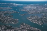
. - AustraliaAustraliaAustralia , officially the Commonwealth of Australia, is a country in the Southern Hemisphere comprising the mainland of the Australian continent, the island of Tasmania, and numerous smaller islands in the Indian and Pacific Oceans. It is the world's sixth-largest country by total area...
: The east coast of Australia features several rias around SydneySydneySydney is the most populous city in Australia and the state capital of New South Wales. Sydney is located on Australia's south-east coast of the Tasman Sea. As of June 2010, the greater metropolitan area had an approximate population of 4.6 million people...
, including Georges RiverGeorges RiverThe Georges River is a waterway in the state of New South Wales in Australia. It rises to the south-west of Sydney near the coal mining town of Appin, and then flows north past Campbelltown, roughly parallel to the Main South Railway...
, Port HackingPort HackingPort Hacking is an Australian estuary, located in Southern Sydney, New South Wales and fed by the Hacking River and several smaller creeks, including Bundeena Creek and The Basin. It is a ria, a river basin which has become submerged by the sea...
and Sydney HarbourPort JacksonPort Jackson, containing Sydney Harbour, is the natural harbour of Sydney, Australia. It is known for its beauty, and in particular, as the location of the Sydney Opera House and Sydney Harbour Bridge...
itself. - New ZealandNew ZealandNew Zealand is an island country in the south-western Pacific Ocean comprising two main landmasses and numerous smaller islands. The country is situated some east of Australia across the Tasman Sea, and roughly south of the Pacific island nations of New Caledonia, Fiji, and Tonga...
: Rias of various scales abound on the eastern shores of the upper North IslandNorth IslandThe North Island is one of the two main islands of New Zealand, separated from the much less populous South Island by Cook Strait. The island is in area, making it the world's 14th-largest island...
. On the west coast, in contrast, they are fewer but larger; Kaipara HarbourKaipara HarbourKaipara Harbour is a large enclosed harbour estuary complex on the north western side of the North Island of New Zealand. The northern part of the harbour is administered by the Kaipara District and the southern part is administered by the Rodney District...
is the country's largest, and the Hokianga Harbour, further north, is of historical significance to the native Māori people. The Marlborough SoundsMarlborough SoundsThe Marlborough Sounds are an extensive network of sea-drowned valleys created by a combination of land subsidence and rising sea levels at the north of the South Island of New Zealand...
at the northern tip of the South IslandSouth IslandThe South Island is the larger of the two major islands of New Zealand, the other being the more populous North Island. It is bordered to the north by Cook Strait, to the west by the Tasman Sea, to the south and east by the Pacific Ocean...
form a large network of rias.
North America
- United StatesUnited StatesThe United States of America is a federal constitutional republic comprising fifty states and a federal district...
: Narragansett BayNarragansett BayNarragansett Bay is a bay and estuary on the north side of Rhode Island Sound. Covering 147 mi2 , the Bay forms New England's largest estuary, which functions as an expansive natural harbor, and includes a small archipelago...
, the Chesapeake BayChesapeake BayThe Chesapeake Bay is the largest estuary in the United States. It lies off the Atlantic Ocean, surrounded by Maryland and Virginia. The Chesapeake Bay's drainage basin covers in the District of Columbia and parts of six states: New York, Pennsylvania, Delaware, Maryland, Virginia, and West...
, and Delaware BayDelaware BayDelaware Bay is a major estuary outlet of the Delaware River on the Northeast seaboard of the United States whose fresh water mixes for many miles with the waters of the Atlantic Ocean. It is in area. The bay is bordered by the State of New Jersey and the State of Delaware...
on the east coast of the United States and San Francisco BaySan Francisco BaySan Francisco Bay is a shallow, productive estuary through which water draining from approximately forty percent of California, flowing in the Sacramento and San Joaquin rivers from the Sierra Nevada mountains, enters the Pacific Ocean...
, on the Pacific coast, are rias. So is Willapa BayWillapa BayWillapa Bay is a bay located on the southwest Pacific coast of Washington state in the United States. The Long Beach Peninsula separates Willapa Bay from the greater expanse of the Pacific Ocean. With over of water surface Willapa Bay is the second largest estuary on the United States Pacific coast...
and Grays Harbor in WA.