
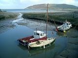
Porlock
Encyclopedia
Porlock is a coastal village and civil parish in Somerset
, England, situated in a deep hollow below Exmoor
, 5 miles (8 km) west of Minehead
. The parish, which includes Hawkcombe and Doverhay, has a population
of 1,377.
In a 2010 survey based on data from the Office of National Statistics Porlock was found to have the most elderly population in Britain with over 40% of the population being of pensionable age.
, an Iron age
hill fort
.
In the Domesday book
the village was known as "Portloc".
Porlock was part of the hundred of Carhampton
.
The area has links with several Romantic poets, and R. D. Blackmore
the author of Lorna Doone
, and is popular with visitors. The visitor centre with exhibits and displays about the local area. Also on display are the bones of an Aurochs
, discovered on Porlock beach in 1999.
groups on matters of crime, security, and traffic. The parish council's role also includes initiating projects for the maintenance and repair of parish facilities, as well as consulting with the district council on the maintenance, repair, and improvement of highways, drainage, footpaths, public transport, and street cleaning. Conservation matters (including trees and listed buildings) and environmental issues are also the responsibility of the council.
The village falls within the Non-metropolitan district
of West Somerset
, which was formed on 1 April 1974 under the Local Government Act 1972
, having previously been part of Williton Rural District
. The district council is responsible for local planning
and building control, local roads, council housing, environmental health
, market
s and fairs, refuse collection and recycling
, cemeteries and crematoria, leisure services, parks, and tourism
.
Somerset County Council
is responsible for running the largest and most expensive local services such as education
, social services, libraries
, main roads, public transport
, policing
and fire services, trading standards
, waste disposal and strategic planning.
As Porlock falls within the Exmoor National Park some functions normally administered by district or county councils have, since 1997, fallen under the Exmoor National Park Authority, which is known as a ‘single purpose’ authority, which aims to "conserve and enhance the natural beauty, wildlife and cultural heritage of the National Parks" and "promote opportunities for the understanding and enjoyment of the special qualities of the Parks by the public", including responsibility for the conservation of the historic environment.
It is also part of the Bridgwater and West Somerset county constituency represented in the House of Commons
of the Parliament of the United Kingdom
. It elects one Member of Parliament (MP)
by the first past the post system of election, and part of the South West England constituency
of the European Parliament
which elects seven MEPs using the d'Hondt method
of party-list proportional representation
.
. Copses of white dead trees remind the visitor of when this was fresh water pasture.
A wooded combe
called Hawkcombe leads about three miles (5 km) from the village up to high open moorland. The stream, (which is called "Hawkcombe Waters"), runs past a Victorian hunting lodge, called The Cleeve, then underground beneath the Overstream Hotel in the centre of the village.
The South West Coast Path
goes through Porlock, many walkers stopping rather than continuing on the gargantuan walk to Lynton
. There is also a 'Coleridge Way' walk.
Culbone
church is said to be the smallest church in England. The main structure is 12th century. Services are still held there, despite the lack of road access — it is a two-mile (3 km) walk from Porlock Weir
, and some 3-4 miles (6.4 km) from Porlock itself.
A new toll road
bypasses the 1-in-4 gradient on Porlock Hill. There is an ancient stone circle on the hill.
can be seen on Porlock Beach. The area was several miles inland until the sea level in the Bristol Channel rose about 7,000 to 8,000 years ago.
dates from the 13th century. The spire was damaged in a storm of 1703. The church has been designated by English Heritage
as a grade I listed building. Within the church is a 15th century tomb of John Harrington who fought alongside Henry V
in France
in 1417.
, who lived nearby at Nether Stowey
(between Bridgwater
and Minehead
), was interrupted during composition of his poem Kubla Khan
by "a person on business from Porlock", and found afterward he could not remember what had come to him in a dream.
Coleridge and William Wordsworth
(who lived nearby at Alfoxden) would often roam the hills and coast on long night walks, leading to local gossip that they were 'spies' for the French
. The Government sent an agent to investigate, but found they were "mere poets". Their walks are celebrated by the Coleridge Way
which ends in Porlock. Their friend Robert Southey
published a poem titled "Porlock" in 1798.
towards Lynmouth
where Glenthorne
is now situated is where Jesus
may have alighted on a trip with Joseph of Arimathea
. This is said to have inspired a passage from William Blake
's famous poem, Milton:
Somerset
The ceremonial and non-metropolitan county of Somerset in South West England borders Bristol and Gloucestershire to the north, Wiltshire to the east, Dorset to the south-east, and Devon to the south-west. It is partly bounded to the north and west by the Bristol Channel and the estuary of the...
, England, situated in a deep hollow below Exmoor
Exmoor
Exmoor is an area of hilly open moorland in west Somerset and north Devon in South West England, named after the main river that flows out of the district, the River Exe. The moor has given its name to a National Park, which includes the Brendon Hills, the East Lyn Valley, the Vale of Porlock and ...
, 5 miles (8 km) west of Minehead
Minehead
Minehead is a coastal town and civil parish in Somerset, England. It lies on the south bank of the Bristol Channel, north-west of the county town of Taunton, from the border with the county of Devon and in proximity of the Exmoor National Park...
. The parish, which includes Hawkcombe and Doverhay, has a population
Population
A population is all the organisms that both belong to the same group or species and live in the same geographical area. The area that is used to define a sexual population is such that inter-breeding is possible between any pair within the area and more probable than cross-breeding with individuals...
of 1,377.
In a 2010 survey based on data from the Office of National Statistics Porlock was found to have the most elderly population in Britain with over 40% of the population being of pensionable age.
History
East of the village is Bury CastleBury Castle, Somerset
Bury Castle is an Iron Age hill fort and 12th medieval century castle near Selworthy, Somerset, England.-Iron Age:Bury Castle was built as a promontory fort, situated over the meeting of the River Exe and River Haddeo. Hill forts developed in the Late Bronze and Early Iron Age, roughly the start of...
, an Iron age
Iron Age
The Iron Age is the archaeological period generally occurring after the Bronze Age, marked by the prevalent use of iron. The early period of the age is characterized by the widespread use of iron or steel. The adoption of such material coincided with other changes in society, including differing...
hill fort
Hill fort
A hill fort is a type of earthworks used as a fortified refuge or defended settlement, located to exploit a rise in elevation for defensive advantage. They are typically European and of the Bronze and Iron Ages. Some were used in the post-Roman period...
.
In the Domesday book
Domesday Book
Domesday Book , now held at The National Archives, Kew, Richmond upon Thames in South West London, is the record of the great survey of much of England and parts of Wales completed in 1086...
the village was known as "Portloc".
Porlock was part of the hundred of Carhampton
Carhampton (hundred)
The Hundred of Carhampton is one of the 40 historical Hundreds in the ceremonial county of Somerset, England, dating from before the Norman conquest during the Anglo-Saxon era although exact dates are unknown. Each hundred had a 'fyrd', which acted as the local defence force and a court which was...
.
The area has links with several Romantic poets, and R. D. Blackmore
R. D. Blackmore
Richard Doddridge Blackmore , referred to most commonly as R. D. Blackmore, was one of the most famous English novelists of the second half of the nineteenth century. Over the course of his career, Blackmore achieved a close following around the world...
the author of Lorna Doone
Lorna Doone
Lorna Doone: A Romance of Exmoor is a novel by Richard Doddridge Blackmore. It is a romance based on a group of historical characters and set in the late 17th century in Devon and Somerset, particularly around the East Lyn Valley area of Exmoor....
, and is popular with visitors. The visitor centre with exhibits and displays about the local area. Also on display are the bones of an Aurochs
Aurochs
The aurochs , the ancestor of domestic cattle, were a type of large wild cattle which inhabited Europe, Asia and North Africa, but is now extinct; it survived in Europe until 1627....
, discovered on Porlock beach in 1999.
Governance
The parish council has responsibility for local issues, including setting an annual precept (local rate) to cover the council’s operating costs and producing annual accounts for public scrutiny. The parish council evaluates local planning applications and works with the local police, district council officers, and neighbourhood watchNeighbourhood Watch (UK)
The Neighbourhood Watch scheme in the United Kingdom is a partnership where people come together to make their communities safer. It involves the Police, Community Safety departments of local authorities, other voluntary organisations and, above all, individuals and families who want to make their...
groups on matters of crime, security, and traffic. The parish council's role also includes initiating projects for the maintenance and repair of parish facilities, as well as consulting with the district council on the maintenance, repair, and improvement of highways, drainage, footpaths, public transport, and street cleaning. Conservation matters (including trees and listed buildings) and environmental issues are also the responsibility of the council.
The village falls within the Non-metropolitan district
Non-metropolitan district
Non-metropolitan districts, or colloquially shire districts, are a type of local government district in England. As created, they are sub-divisions of non-metropolitan counties in a so-called "two-tier" arrangement...
of West Somerset
West Somerset
West Somerset is a local government district in the English county of Somerset. The council covers a largely rural area, with a population of 35,075 in an area of ....
, which was formed on 1 April 1974 under the Local Government Act 1972
Local Government Act 1972
The Local Government Act 1972 is an Act of Parliament in the United Kingdom that reformed local government in England and Wales on 1 April 1974....
, having previously been part of Williton Rural District
Williton Rural District
Williton was a rural district in Somerset, England, from 1894 to 1974.It was created in 1894 under the Local Government Act 1894.In 1974 it was abolished under the Local Government Act 1972 when it became part of West Somerset....
. The district council is responsible for local planning
Planning permission
Planning permission or planning consent is the permission required in the United Kingdom in order to be allowed to build on land, or change the use of land or buildings. Within the UK the occupier of any land or building will need title to that land or building , but will also need "planning...
and building control, local roads, council housing, environmental health
Environmental health
Environmental health is the branch of public health that is concerned with all aspects of the natural and built environment that may affect human health...
, market
Market
A market is one of many varieties of systems, institutions, procedures, social relations and infrastructures whereby parties engage in exchange. While parties may exchange goods and services by barter, most markets rely on sellers offering their goods or services in exchange for money from buyers...
s and fairs, refuse collection and recycling
Recycling
Recycling is processing used materials into new products to prevent waste of potentially useful materials, reduce the consumption of fresh raw materials, reduce energy usage, reduce air pollution and water pollution by reducing the need for "conventional" waste disposal, and lower greenhouse...
, cemeteries and crematoria, leisure services, parks, and tourism
Tourism
Tourism is travel for recreational, leisure or business purposes. The World Tourism Organization defines tourists as people "traveling to and staying in places outside their usual environment for not more than one consecutive year for leisure, business and other purposes".Tourism has become a...
.
Somerset County Council
Somerset County Council
Somerset County Council is the county council of Somerset in the South West of England, an elected local government authority responsible for the most significant local government services in most of the county.-Area covered:...
is responsible for running the largest and most expensive local services such as education
Local Education Authority
A local education authority is a local authority in England and Wales that has responsibility for education within its jurisdiction...
, social services, libraries
Library
In a traditional sense, a library is a large collection of books, and can refer to the place in which the collection is housed. Today, the term can refer to any collection, including digital sources, resources, and services...
, main roads, public transport
Public transport
Public transport is a shared passenger transportation service which is available for use by the general public, as distinct from modes such as taxicab, car pooling or hired buses which are not shared by strangers without private arrangement.Public transport modes include buses, trolleybuses, trams...
, policing
Police
The police is a personification of the state designated to put in practice the enforced law, protect property and reduce civil disorder in civilian matters. Their powers include the legitimized use of force...
and fire services, trading standards
Trading Standards
Trading Standards is the name given to local authority departments in the UK formerly known as Weights and Measures. These departments investigate commercial organisations that carry out trade in unethical ways or outside the scope of the law.-History:...
, waste disposal and strategic planning.
As Porlock falls within the Exmoor National Park some functions normally administered by district or county councils have, since 1997, fallen under the Exmoor National Park Authority, which is known as a ‘single purpose’ authority, which aims to "conserve and enhance the natural beauty, wildlife and cultural heritage of the National Parks" and "promote opportunities for the understanding and enjoyment of the special qualities of the Parks by the public", including responsibility for the conservation of the historic environment.
It is also part of the Bridgwater and West Somerset county constituency represented in the House of Commons
British House of Commons
The House of Commons is the lower house of the Parliament of the United Kingdom, which also comprises the Sovereign and the House of Lords . Both Commons and Lords meet in the Palace of Westminster. The Commons is a democratically elected body, consisting of 650 members , who are known as Members...
of the Parliament of the United Kingdom
Parliament of the United Kingdom
The Parliament of the United Kingdom of Great Britain and Northern Ireland is the supreme legislative body in the United Kingdom, British Crown dependencies and British overseas territories, located in London...
. It elects one Member of Parliament (MP)
Member of Parliament
A Member of Parliament is a representative of the voters to a :parliament. In many countries with bicameral parliaments, the term applies specifically to members of the lower house, as upper houses often have a different title, such as senate, and thus also have different titles for its members,...
by the first past the post system of election, and part of the South West England constituency
South West England (European Parliament constituency)
South West England is a constituency of the European Parliament. For 2009 it elects 6 MEPs using the d'Hondt method of party-list proportional representation, reduced from 7 in 2004.-Boundaries:...
of the European Parliament
European Parliament
The European Parliament is the directly elected parliamentary institution of the European Union . Together with the Council of the European Union and the Commission, it exercises the legislative function of the EU and it has been described as one of the most powerful legislatures in the world...
which elects seven MEPs using the d'Hondt method
D'Hondt method
The d'Hondt method is a highest averages method for allocating seats in party-list proportional representation. The method described is named after Belgian mathematician Victor D'Hondt who described it in 1878...
of party-list proportional representation
Party-list proportional representation
Party-list proportional representation systems are a family of voting systems emphasizing proportional representation in elections in which multiple candidates are elected...
.
Geography
The village adjoins a Porlock Ridge and Saltmarsh nature reserve created when the lowland behind a high shingle embankment was breached by the sea in the 1990s, which has now been designated as a Site of Special Scientific InterestSite of Special Scientific Interest
A Site of Special Scientific Interest is a conservation designation denoting a protected area in the United Kingdom. SSSIs are the basic building block of site-based nature conservation legislation and most other legal nature/geological conservation designations in Great Britain are based upon...
. Copses of white dead trees remind the visitor of when this was fresh water pasture.
A wooded combe
Valley
In geology, a valley or dale is a depression with predominant extent in one direction. A very deep river valley may be called a canyon or gorge.The terms U-shaped and V-shaped are descriptive terms of geography to characterize the form of valleys...
called Hawkcombe leads about three miles (5 km) from the village up to high open moorland. The stream, (which is called "Hawkcombe Waters"), runs past a Victorian hunting lodge, called The Cleeve, then underground beneath the Overstream Hotel in the centre of the village.
The South West Coast Path
South West Coast Path
The South West Coast Path is Britain's longest waymarked long-distance footpath and a National Trail. It stretches for , running from Minehead in Somerset, along the coasts of Devon and Cornwall, to Poole Harbour in Dorset. Since it rises and falls with every river mouth, it is also one of the more...
goes through Porlock, many walkers stopping rather than continuing on the gargantuan walk to Lynton
Lynton
Lynton is a small town in Devon, England. It lies on the northern edge of Exmoor and is located at the top of a gorge above Lynmouth, to which it is connected by the Lynton and Lynmouth Cliff Railway...
. There is also a 'Coleridge Way' walk.
Culbone
Culbone
Culbone is a hamlet consisting of little more than the parish church and a few houses, in the parish of Oare in the Exmoor National Park, Somerset, England. As there is no road access it is a two-mile walk from Porlock Weir, and some four miles from Porlock itself.The village is situated in a...
church is said to be the smallest church in England. The main structure is 12th century. Services are still held there, despite the lack of road access — it is a two-mile (3 km) walk from Porlock Weir
Porlock Weir
Porlock Weir lies about 1.5 miles west of Porlock, Somerset, England and is a small settlement which has grown up around the harbour. It is a popular visitor attraction....
, and some 3-4 miles (6.4 km) from Porlock itself.
A new toll road
Toll road
A toll road is a privately or publicly built road for which a driver pays a toll for use. Structures for which tolls are charged include toll bridges and toll tunnels. Non-toll roads are financed using other sources of revenue, most typically fuel tax or general tax funds...
bypasses the 1-in-4 gradient on Porlock Hill. There is an ancient stone circle on the hill.
Submerged forest
At low tide the remains of a submerged forestSubmerged forest
Submerged forest is a term used to describe the remains of trees which have been submerged by marine transgression, i.e. sea level rise and petrified. Examples can be found at low tide on the fringes of the submerged landmass known as Doggerland, around the coast of England and Wales, the Channel...
can be seen on Porlock Beach. The area was several miles inland until the sea level in the Bristol Channel rose about 7,000 to 8,000 years ago.
Church
The Church of St DubriciusChurch of St Dubricius, Porlock
The Church of St Dubricius in Porlock, Somerset, England dates from the 13th century. The church has been designated by English Heritage as a grade I listed building....
dates from the 13th century. The spire was damaged in a storm of 1703. The church has been designated by English Heritage
English Heritage
English Heritage . is an executive non-departmental public body of the British Government sponsored by the Department for Culture, Media and Sport...
as a grade I listed building. Within the church is a 15th century tomb of John Harrington who fought alongside Henry V
Henry V of England
Henry V was King of England from 1413 until his death at the age of 35 in 1422. He was the second monarch belonging to the House of Lancaster....
in France
France
The French Republic , The French Republic , The French Republic , (commonly known as France , is a unitary semi-presidential republic in Western Europe with several overseas territories and islands located on other continents and in the Indian, Pacific, and Atlantic oceans. Metropolitan France...
in 1417.
"Person from Porlock"
The poet Samuel Taylor ColeridgeSamuel Taylor Coleridge
Samuel Taylor Coleridge was an English poet, Romantic, literary critic and philosopher who, with his friend William Wordsworth, was a founder of the Romantic Movement in England and a member of the Lake Poets. He is probably best known for his poems The Rime of the Ancient Mariner and Kubla...
, who lived nearby at Nether Stowey
Nether Stowey
Nether Stowey is a large village in the Sedgemoor district of Somerset, South West England. It sits in the foothills of the Quantock Hills , just below Over Stowey...
(between Bridgwater
Bridgwater
Bridgwater is a market town and civil parish in Somerset, England. It is the administrative centre of the Sedgemoor district, and a major industrial centre. Bridgwater is located on the major communication routes through South West England...
and Minehead
Minehead
Minehead is a coastal town and civil parish in Somerset, England. It lies on the south bank of the Bristol Channel, north-west of the county town of Taunton, from the border with the county of Devon and in proximity of the Exmoor National Park...
), was interrupted during composition of his poem Kubla Khan
Kubla Khan
Kubla Khan is a poem by Samuel Taylor Coleridge, completed in 1797 and published in Christabel, Kubla Khan, and the Pains of Sleep in 1816...
by "a person on business from Porlock", and found afterward he could not remember what had come to him in a dream.
Coleridge and William Wordsworth
William Wordsworth
William Wordsworth was a major English Romantic poet who, with Samuel Taylor Coleridge, helped to launch the Romantic Age in English literature with the 1798 joint publication Lyrical Ballads....
(who lived nearby at Alfoxden) would often roam the hills and coast on long night walks, leading to local gossip that they were 'spies' for the French
France
The French Republic , The French Republic , The French Republic , (commonly known as France , is a unitary semi-presidential republic in Western Europe with several overseas territories and islands located on other continents and in the Indian, Pacific, and Atlantic oceans. Metropolitan France...
. The Government sent an agent to investigate, but found they were "mere poets". Their walks are celebrated by the Coleridge Way
Coleridge Way
The Coleridge Way is a footpath in Somerset, England.It was opened in April 2005, and follows the walks taken by poet Samuel Taylor Coleridge, to Porlock, starting from Coleridge Cottage at Nether Stowey, where he once lived.The footpath is waymarked...
which ends in Porlock. Their friend Robert Southey
Robert Southey
Robert Southey was an English poet of the Romantic school, one of the so-called "Lake Poets", and Poet Laureate for 30 years from 1813 to his death in 1843...
published a poem titled "Porlock" in 1798.
William Blake
Legend has it that the area beyond CulboneCulbone
Culbone is a hamlet consisting of little more than the parish church and a few houses, in the parish of Oare in the Exmoor National Park, Somerset, England. As there is no road access it is a two-mile walk from Porlock Weir, and some four miles from Porlock itself.The village is situated in a...
towards Lynmouth
Lynmouth
Lynmouth is a village in Devon, England, on the north edge of Exmoor.The village straddles the confluence of the West Lyn and East Lyn rivers, in a gorge below Lynton, to which it is connected by the Lynton and Lynmouth Cliff Railway....
where Glenthorne
Glenthorne
Glenthorne is a 13.3 hectare geological Site of Special Scientific Interest in the parish of Oare within the Exmoor National Park, on the border of Somerset and Devon, notified in 1989....
is now situated is where Jesus
Jesus
Jesus of Nazareth , commonly referred to as Jesus Christ or simply as Jesus or Christ, is the central figure of Christianity...
may have alighted on a trip with Joseph of Arimathea
Joseph of Arimathea
Joseph of Arimathea was, according to the Gospels, the man who donated his own prepared tomb for the burial of Jesus after Jesus' Crucifixion. He is mentioned in all four Gospels.-Gospel references:...
. This is said to have inspired a passage from William Blake
William Blake
William Blake was an English poet, painter, and printmaker. Largely unrecognised during his lifetime, Blake is now considered a seminal figure in the history of both the poetry and visual arts of the Romantic Age...
's famous poem, Milton:
- "And did those feet in ancient timeAnd did those feet in ancient time"And did those feet in ancient time" is a short poem by William Blake from the preface to his epic Milton a Poem, one of a collection of writings known as the Prophetic Books. The date on the title page of 1804 for Milton is probably when the plates were begun, but the poem was printed c. 1808...
- Walk upon England’s mountains green?
- And was the Holy Lamb of God
- On England’s pleasant pastures seen?
- And did the countenance divine
- Shine forth upon our clouded hills?
- And was Jerusalem builded here
- Among these dark satanic mills?"
External links
- www.porlock.co.uk by the Porlock Tourist Association.
- www.porlock.org Porlock Vale Community Website.